Tweet from the Guru, JB:
"Severe cold for season likely last week of Feb for much of nation, centered in the plains"
Texas Winter 2011-2012...
Moderator: S2k Moderators
Forum rules
 The posts in this forum are NOT official forecast and should not be used as such. They are just the opinion of the poster and may or may not be backed by sound meteorological data. They are NOT endorsed by any professional institution or STORM2K.

The posts in this forum are NOT official forecast and should not be used as such. They are just the opinion of the poster and may or may not be backed by sound meteorological data. They are NOT endorsed by any professional institution or STORM2K.
-
aggiecutter
- Category 5

- Posts: 1755
- Joined: Thu Oct 14, 2004 9:22 pm
- Location: Texarkana
Re: Texas Winter 2011-2012...
0 likes
-
srainhoutx

- S2K Supporter

- Posts: 6919
- Age: 68
- Joined: Sun Jan 14, 2007 11:34 am
- Location: Haywood County, NC
- Contact:
Re: Texas Winter 2011-2012...
Not saying anything is going to happen, but the HPC will be tasking an additional G-IV flight as well as an additional C-130 or two for sampling the northern stream energy out over the Pacific. As of Wednesday, my hunch is we have yet to see what the sensible solution will actually be in model world regarding the weekend and beyond.
0 likes
Carla/Alicia/Jerry(In The Eye)/Michelle/Charley/Ivan/Dennis/Katrina/Rita/Wilma/Ike/Harvey
Member: National Weather Association
Wx Infinity Forums
http://wxinfinity.com/index.php
Facebook.com/WeatherInfinity
Twitter @WeatherInfinity
Member: National Weather Association
Wx Infinity Forums
http://wxinfinity.com/index.php
Facebook.com/WeatherInfinity
Twitter @WeatherInfinity
Re: Texas Winter 2011-2012...
aggiecutter wrote:Tweet from the Guru, JB:
"Severe cold for season likely last week of Feb for much of nation, centered in the plains"
Come on JB, hit the hammer on the nail on this one!
0 likes
-
Portastorm

- Storm2k Moderator

- Posts: 9955
- Age: 63
- Joined: Fri Jul 11, 2003 9:16 am
- Location: Round Rock, TX
- Contact:
Re: Texas Winter 2011-2012...
Oh, I know we're dealing with "stale, modified Canadian air" this weekend. That is why I said I was surprised by the 12z NAM run and further elaborated that I still think this weekend's "event" will be mostly (if not all) a cold rain. I'd have to see several more cycles of runs like this 12z NAM before I change the Portastorm Weather Center's weekend duty roster. 
Here ... here's how we can work this out between us ... I'll give you your 81 degrees some time next week. In fact, I'll give you two days of that. And then, you give me an Arctic outbreak for Feb. 24-29. Deal?!
Here ... here's how we can work this out between us ... I'll give you your 81 degrees some time next week. In fact, I'll give you two days of that. And then, you give me an Arctic outbreak for Feb. 24-29. Deal?!
0 likes
Any forecasts under my name are to be taken with a grain of salt. Get your best forecasts from the National Weather Service and National Hurricane Center.
-
Portastorm
- Storm2k Moderator
- Posts: 9955
- Age: 63
- Joined: Fri Jul 11, 2003 9:16 am
- Location: Round Rock, TX
- Contact:
Re: Texas Winter 2011-2012...
Portastorm wrote:Oh, I know we're dealing with "stale, modified Canadian air" this weekend. That is why I said I was surprised by the 12z NAM run and further elaborated that I still think this weekend's "event" will be mostly (if not all) a cold rain. I'd have to see several more cycles of runs like this 12z NAM before I change the Portastorm Weather Center's weekend duty roster.
Here ... here's how we can work this out between us ... I'll give you your 81 degrees some time next week. In fact, I'll give you two days of that. And then, you give me an Arctic outbreak for Feb. 24-29. Deal?!
And by the way ... I have read where starting with the 0z GFS run last night, the GFS has increased its abilities with greater resolution in longer range. Is that correct?
0 likes
Any forecasts under my name are to be taken with a grain of salt. Get your best forecasts from the National Weather Service and National Hurricane Center.

I heard that also. Here is a link about what all they are doing with it. http://www.nws.noaa.gov/os/notification/tin11-47gefs_reincrease_aab.htm
0 likes
-
MGC

- S2K Supporter
- Posts: 5940
- Joined: Sun Mar 23, 2003 9:05 pm
- Location: Pass Christian MS, or what is left.
Re: Texas Winter 2011-2012...
I see many here are still in bed with the long range GFS.....how many times will you fall for this sucker punch and get pardon the pun....torched? The models for the most part have been horrible this winter.....MGC
0 likes
-
wxman57

- Moderator-Pro Met

- Posts: 23173
- Age: 68
- Joined: Sat Jun 21, 2003 8:06 pm
- Location: Houston, TX (southwest)
Re: Texas Winter 2011-2012...
Portastorm wrote:Portastorm wrote:Oh, I know we're dealing with "stale, modified Canadian air" this weekend. That is why I said I was surprised by the 12z NAM run and further elaborated that I still think this weekend's "event" will be mostly (if not all) a cold rain. I'd have to see several more cycles of runs like this 12z NAM before I change the Portastorm Weather Center's weekend duty roster.
Here ... here's how we can work this out between us ... I'll give you your 81 degrees some time next week. In fact, I'll give you two days of that. And then, you give me an Arctic outbreak for Feb. 24-29. Deal?!
And by the way ... I have read where starting with the 0z GFS run last night, the GFS has increased its abilities with greater resolution in longer range. Is that correct?
OK, deal! As long as IAH (Bush Airport, Houston) doesn't record below 29F. New GFS is not very cold for the 24-29. Lowest temp of 40 here in Houston vs. near 30 on the 00Z run. Haven't heard about any modifications to the long-range GFS.
0 likes

Re: Texas Winter 2011-2012...
I think it's unlikely Portastorm can deliver that 80+ promise wxman57 by the end of the month. MJO is now looking to be stuck in phases 2/3 for awhile.
The storms the next week are getting bigger. Regardless of winter weather, all said and done much of Texas is in a win win situation. Plenty of pouring rain! Many areas of Texas have seen more rain the past two months than much of last year. I think we can feel safe (for now) from a scorching summer like last year as ground moisture isn't going to aid in surface ridging to enhance the heat.
The storms the next week are getting bigger. Regardless of winter weather, all said and done much of Texas is in a win win situation. Plenty of pouring rain! Many areas of Texas have seen more rain the past two months than much of last year. I think we can feel safe (for now) from a scorching summer like last year as ground moisture isn't going to aid in surface ridging to enhance the heat.
0 likes
The above post and any post by Ntxw is NOT an official forecast and should not be used as such. It is just the opinion of the poster and may or may not be backed by sound meteorological data. It is NOT endorsed by any professional institution including Storm2k. For official information, please refer to NWS products.
Help support Storm2K!
-
orangeblood
- S2K Supporter
- Posts: 3895
- Joined: Tue Dec 15, 2009 6:14 pm
- Location: Fort Worth, TX
Re: Texas Winter 2011-2012...
Today's model suites seem to have a better handle on the setup for this weekend. Most models are depicting the strong upper low across the southwest to open up and move across the southern plains bringing just cold rain to most of Texas. The NAM on the other hand keeps the strong closed upper low together and moves it across central Texas on Saturday. If the upper low stays together and is as strong as the NAM forecasts, then I would expect some portions of central into North Texas to experience wintry precip sometime on Saturday....due to dynamic cooling of the column on the backside of the ULL.
Edit: Looks like the NAM is trending towards the other models....transitioning from a closed upper level low to an open trough as it moves across the state.
The following post is NOT an official forecast and should not be used as such. It is just the opinion of the poster and may or may not be backed by sound meteorological data. It is NOT endorsed by any professional institution including storm2k.org. For official information, please refer to NWS products.
0 likes
-
Portastorm
- Storm2k Moderator
- Posts: 9955
- Age: 63
- Joined: Fri Jul 11, 2003 9:16 am
- Location: Round Rock, TX
- Contact:
Re: Texas Winter 2011-2012...
orangeblood wrote:Today's model suites seem to have a better handle on the setup for this weekend. Most models are depicting the strong upper low across the southwest to open up and move across the southern plains bringing just cold rain to most of Texas. The NAM on the other hand keeps the strong closed upper low together and moves it across central Texas on Saturday. If the upper low stays together and is as strong as the NAM forecasts, then I would expect some portions of central into North Texas to experience wintry precip sometime on Saturday....due to dynamic cooling of the column on the backside of the ULL.
Edit: Looks like the NAM is trending towards the other models....transitioning from a closed upper level low to an open trough as it moves across the state.
The following post is NOT an official forecast and should not be used as such. It is just the opinion of the poster and may or may not be backed by sound meteorological data. It is NOT endorsed by any professional institution including storm2k.org. For official information, please refer to NWS products.
Nice post, orangeblood. That does seem to be the most sensible solution for this weekend's system. We will all welcome the rain, that's for sure.
0 likes
Any forecasts under my name are to be taken with a grain of salt. Get your best forecasts from the National Weather Service and National Hurricane Center.
-
Texas Snowman

- Storm2k Moderator
- Posts: 6197
- Joined: Fri Jan 25, 2008 11:29 am
- Location: Denison, Texas
Re: Texas Winter 2011-2012...
Ntxw wrote:I think it's unlikely Portastorm can deliver that 80+ promise wxman57 by the end of the month. MJO is now looking to be stuck in phases 2/3 for awhile.
The storms the next week are getting bigger. Regardless of winter weather, all said and done much of Texas is in a win win situation. Plenty of pouring rain! Many areas of Texas have seen more rain the past two months than much of last year. I think we can feel safe (for now) from a scorching summer like last year as ground moisture isn't going to aid in surface ridging to enhance the heat.
I for one am hoping for a nasty, cool, wet spring.
Party because of the drought.
And party so all of us cold/snow lovers on this thread can continuously get on and torment our resident Heat Miser as his weekends of blissful bike riding are drowned like a soggy rat!
0 likes
The above post and any post by Texas Snowman is NOT an official forecast and should not be used as such. It is just the opinion of the poster and may or may not be backed by sound meteorological data. It is NOT endorsed by any professional institution including storm2k.org. For official information, please refer to NWS products.

Re: Texas Winter 2011-2012...
At least the long range is continuing to give us hope! 18z continues the trend.
But...we all know how that goes.
But...we all know how that goes.
0 likes
I'm not looking for super cold anymore, we're two months removed from the winter solstice. Record lows are creeping up to the upper teens. However, we don't need super cold for snow . The +PNA is heading downwards and usually when it does so look for a big storm in the southern plains (or middle of the country) followed by a duration of cold/cooler values. Though it doesn't look like the PNA is going to be negative anytime soon, just stay around neutral. Makes sense with our MJO signal.
0 likes
The above post and any post by Ntxw is NOT an official forecast and should not be used as such. It is just the opinion of the poster and may or may not be backed by sound meteorological data. It is NOT endorsed by any professional institution including Storm2k. For official information, please refer to NWS products.
Help support Storm2K!
Help support Storm2K!
-
Rgv20

- S2K Supporter
- Posts: 2466
- Age: 39
- Joined: Wed Jan 05, 2011 5:42 pm
- Location: Edinburg/McAllen Tx
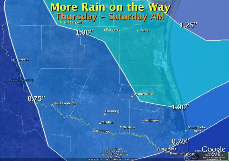
More rain for the valley on the way! 
0 likes
The following post is NOT an official forecast and should not be used as such. It is just the opinion of the poster and may or may not be backed by sound meteorological data. It is NOT endorsed by any professional institution including storm2k.org For Official Information please refer to the NHC and NWS products.
-
Rgv20
- S2K Supporter
- Posts: 2466
- Age: 39
- Joined: Wed Jan 05, 2011 5:42 pm
- Location: Edinburg/McAllen Tx
There is a chance of some severe storms for south texas come friday...main threat would be sleet...I mean hail 
SPC's discussion for Friday.
...SOUTH TEXAS INTO TEXAS COASTAL AREAS...
CONFIDENCE IS INCREASING THAT LOW-LEVEL MOISTURE ADVECTION...ABOVE
THE OFFSHORE FRONTAL INVERSION...COINCIDENT WITH STEEPENING LAPSE
RATES AND INCREASING VERTICAL SHEAR IN THE CONVECTIVE LAYER
ASSOCIATED WITH THE APPROACHING UPPER IMPULSE...COULD YIELD AN
ENVIRONMENT CONDUCIVE TO A FEW STORMS CAPABLE OF PRODUCING AT LEAST
MARGINALLY SEVERE HAIL. 5 PERCENT SEVERE PROBABILITIES HAVE BEEN
ADDED FOR NOW...BUT POTENTIAL FOR STRONGER DESTABILIZATION WILL HAVE
TO BE MONITORED IN SUBSEQUENT OUTLOOKS FOR THIS TIME PERIOD.
..KERR.. 02/16/2012
0 likes
The following post is NOT an official forecast and should not be used as such. It is just the opinion of the poster and may or may not be backed by sound meteorological data. It is NOT endorsed by any professional institution including storm2k.org For Official Information please refer to the NHC and NWS products.
-
Texas Snowman
- Storm2k Moderator
- Posts: 6197
- Joined: Fri Jan 25, 2008 11:29 am
- Location: Denison, Texas
Re:
Rgv20 wrote:There is a chance of some severe storms for south texas come friday...main threat would be sleet...I mean hail
Sorry wxman57, I just can't help myself: Rgv20, you sure the main threat isn't graupel?
0 likes
The above post and any post by Texas Snowman is NOT an official forecast and should not be used as such. It is just the opinion of the poster and may or may not be backed by sound meteorological data. It is NOT endorsed by any professional institution including storm2k.org. For official information, please refer to NWS products.
-
wxman57
- Moderator-Pro Met
- Posts: 23173
- Age: 68
- Joined: Sat Jun 21, 2003 8:06 pm
- Location: Houston, TX (southwest)
Re: Texas Winter 2011-2012...
Doesn't look like there will be any winter surprise across Texas THIS weekend, as temps at the surface and aloft are quite a bit warmer than last weekend. Surface temps in the 40s to low 50s and 850mb temps well above freezing means only a rain threat.
And I don't know what JB is talking about when he says "severe cold centered in the Plains" the last week of February. I don't see anything to indicate more than just slightly below-normal temps in the Plains. He's the biggest cold-mongerer of them all. Give it up, Joe!
And I don't know what JB is talking about when he says "severe cold centered in the Plains" the last week of February. I don't see anything to indicate more than just slightly below-normal temps in the Plains. He's the biggest cold-mongerer of them all. Give it up, Joe!
0 likes
-
weatherdude1108
- Category 5
- Posts: 4228
- Joined: Tue Dec 13, 2011 1:04 pm
- Location: Northwest Austin/Cedar Park, TX
Possible Flash Flood Watch later for Central Texas. Only ice mentioned is possible small hail. Mostly heavy rain. The hill country needs the flash flooding to boost our 38% full lake levels. But looks like most of the flood threat will be east of where it counts most unfortunately.  But, who knows?
  It was originally predicted to be dry and warm all Winter.
AREA FORECAST DISCUSSION...UPDATED
NATIONAL WEATHER SERVICE AUSTIN/SAN ANTONIO TX
713 AM CST THU FEB 16 2012
.UPDATE...
INCREASED POPS AND CLOUD COVERAGE FOR THE FIRST PERIOD
AS PACIFIC MOISTURE AND A SHORT WAVE TROUGH MOVES OVER
NORTHEASTERN MEXICO TOWARD SOUTHWEST TEXAS. CHANCES FOR
SHOWERS AND THUNDERSTORMS TO INCREASE SIGNIFICANTLY WITHIN
THE NEXT 24 HOURS AS A DEEPER UPPER DISTURBANCE MOVES ACROSS
SOUTH CENTRAL TEXAS WITH POSSIBLE HEAVY RAINS LATE FRIDAY INTO
EARLY SATURDAY. STORM RAINFALL TOTALS COULD RANGE FROM ONE QUARTER
INCH TO ONE INCH...WITH UP TWO INCHES OVER THE SOUTHEAST COUNTIES.
0 likes
The preceding post is NOT an official forecast, and should not be used as such. It is only the opinion of the poster and may or may not be backed by sound meteorological data. It is NOT endorsed by any professional institution including storm2k.org. For Official Information please refer to the NHC and NWS products.
Who is online
Users browsing this forum: No registered users and 27 guests