Global model runs discussion

Moderator: S2k Moderators

Message
Author
User avatar
CourierPR
Category 5
Category 5
Posts: 1335
Age: 71
Joined: Tue Aug 31, 2004 7:53 pm
Location: Pompano Beach, Florida

Re:

#3981 Postby CourierPR » Fri Jul 20, 2012 5:43 am

gatorcane wrote:There is alot of SAL and dry stable air across all of the MDR. It's pretty typical for July. We will need to see a few wave moves through to moisten up the MDR but we are still about 3-4 weeks (based on climatology) before things start to ramp up in the far eastern Atlantic.


Gatorcane, with a pending el nino, will we see a ramp up in activity in the far eastern Atlantic, or will the activity be closer to home?
0 likes   

Dean4Storms
S2K Supporter
S2K Supporter
Posts: 6358
Age: 62
Joined: Sun Aug 31, 2003 1:01 pm
Location: Miramar Bch. FL

#3982 Postby Dean4Storms » Fri Jul 20, 2012 11:49 am

If that large high persists driving Saharan dust out into the MDR then I think the CV season will be lacking and add an increasing El Nino you have a recipe for a down year east of 50W.

I believe much of this season will be closer to home development, western Carib, Bahamas area, Gulf and off the SE Coast.

If the JAMSTEC model forecasts are realized for Sept.-Nov. then we will likely have strong troughing in the east which will enhance SW wind shear and dry air. This would tend to create weaker systems.
0 likes   

User avatar
cycloneye
Admin
Admin
Posts: 145328
Age: 68
Joined: Thu Oct 10, 2002 10:54 am
Location: San Juan, Puerto Rico

Re: Global Model Runs Discussion

#3983 Postby cycloneye » Fri Jul 20, 2012 11:56 am

There is nothing on the long range 12z GFS going all the way to August 5th. The waiting game continues.

12z GFS loop
0 likes   
Visit the Caribbean-Central America Weather Thread where you can find at first post web cams,radars
and observations from Caribbean basin members Click Here

User avatar
cycloneye
Admin
Admin
Posts: 145328
Age: 68
Joined: Thu Oct 10, 2002 10:54 am
Location: San Juan, Puerto Rico

Re: Global Model Runs Discussion

#3984 Postby cycloneye » Fri Jul 20, 2012 2:16 pm

Well folks,at least the 12z ECMWF has a low closed with an isobar SW of CV islands at 168 hours. A little bit of progress. :)

Image
0 likes   
Visit the Caribbean-Central America Weather Thread where you can find at first post web cams,radars
and observations from Caribbean basin members Click Here

User avatar
mcheer23
Professional-Met
Professional-Met
Posts: 436
Age: 32
Joined: Sun Jun 24, 2012 8:24 pm
Location: Sugar Land, Texas

Re: Global Model Runs Discussion

#3985 Postby mcheer23 » Fri Jul 20, 2012 8:02 pm

cycloneye wrote:Well folks,at least the 12z ECMWF has a low closed with an isobar SW of CV islands at 168 hours. A little bit of progress. :)

http://oi50.tinypic.com/mmyaux.jpg
cycloneye wrote:Well folks,at least the 12z ECMWF has a low closed with an isobar SW of CV islands at 168 hours. A little bit of progress. :)

http://oi50.tinypic.com/mmyaux.jpg


Cape Verde train soon to start ? :P
0 likes   

User avatar
cycloneye
Admin
Admin
Posts: 145328
Age: 68
Joined: Thu Oct 10, 2002 10:54 am
Location: San Juan, Puerto Rico

Re: Global Model Runs Discussion

#3986 Postby cycloneye » Sat Jul 21, 2012 7:10 am

ConvergenceZone wrote:
cycloneye wrote:So far none of the models show anything of significance on the pipe. And GFS which goes already into early August still doesn't have anything. Let's wait and see when the models will start to latch on something.


The good news is that I'm not seeing any early season cancel posts which are usually quite numerous in the month of July if there's no activity..... :wink:


You would have seen already a season cancel thread with many replies if Alberto,Beryl,Chris and Debby would not have formed. :)

By the way,nothing important on the GFS long range thru August 6.
0 likes   
Visit the Caribbean-Central America Weather Thread where you can find at first post web cams,radars
and observations from Caribbean basin members Click Here

User avatar
gatorcane
S2K Supporter
S2K Supporter
Posts: 23691
Age: 47
Joined: Sun Mar 13, 2005 3:54 pm
Location: Boca Raton, FL

Re: Re:

#3987 Postby gatorcane » Sat Jul 21, 2012 11:21 am

CourierPR wrote:
gatorcane wrote:There is alot of SAL and dry stable air across all of the MDR. It's pretty typical for July. We will need to see a few wave moves through to moisten up the MDR but we are still about 3-4 weeks (based on climatology) before things start to ramp up in the far eastern Atlantic.


Gatorcane, with a pending el nino, will we see a ramp up in activity in the far eastern Atlantic, or will the activity be closer to home?


The posts in this forum are NOT official forecast and should not be used as such. They are just the opinion of the poster and may or may not be backed by sound meteorological data. They are NOT endorsed by any professional institution or storm2k.org. For official information, please refer to the NHC and NWS products.


It's difficult to say. El nino would suggest less activity closer to home though it looks to be weak during the peak of the Atlantic season this year. The latest MJO forecast suggests rising air returns to much of the Atlantic basin by mid August which perhaps not by coincidence is when we typically see the ramp up in activity from a climatological perspective:

Image

Image
0 likes   

User avatar
ConvergenceZone
Category 5
Category 5
Posts: 5194
Joined: Fri Jul 29, 2005 1:40 am
Location: Northern California

Re: Global Model Runs Discussion

#3988 Postby ConvergenceZone » Sat Jul 21, 2012 12:41 pm

cycloneye wrote:
ConvergenceZone wrote:
cycloneye wrote:So far none of the models show anything of significance on the pipe. And GFS which goes already into early August still doesn't have anything. Let's wait and see when the models will start to latch on something.


The good news is that I'm not seeing any early season cancel posts which are usually quite numerous in the month of July if there's no activity..... :wink:


You would have seen already a season cancel thread with many replies if Alberto,Beryl,Chris and Debby would not have formed. :)

By the way,nothing important on the GFS long range thru August 6.


HAHA, that's true. I think the reason the "season cancel" posts were so numerous in past years is because we had those couple of years where we had way above normal activity and thus the expectations were for it to keep continuing......

Honestly, I have absolutely no clue on what to expect this year. Will it pick up suddenly? or will it just happen to be a low output year. I remember last year we got through quite a bit of the alphabet, so hard to say if this year will be just the opposite or if it will start ramping up in August like we expect....
0 likes   

User avatar
GCANE
S2K Supporter
S2K Supporter
Posts: 11497
Joined: Mon Oct 22, 2007 8:03 am

Re: Global Model Runs Discussion

#3989 Postby GCANE » Sun Jul 22, 2012 3:58 am

GFS is latching on to something coming off Africa in about 100 hrs.

http://moe.met.fsu.edu/cgi-bin/gfstc2.c ... =Animation

Has it spinning up SE of CV thru 144 hrs.

SAL currently looking clear in that area.

http://tropic.ssec.wisc.edu/real-time/sal/splitE.jpg
0 likes   

User avatar
GCANE
S2K Supporter
S2K Supporter
Posts: 11497
Joined: Mon Oct 22, 2007 8:03 am

Re: Global Model Runs Discussion

#3990 Postby GCANE » Sun Jul 22, 2012 4:14 am

GCANE wrote:GFS is latching on to something coming off Africa in about 100 hrs.

http://moe.met.fsu.edu/cgi-bin/gfstc2.c ... =Animation

Has it spinning up SE of CV thru 144 hrs.

SAL currently looking clear in that area.

http://tropic.ssec.wisc.edu/real-time/sal/splitE.jpg


From another site, GFS is showing good TPW convergence around a 1007 to 1010mb surface low.

Pretty nice rise in the ITCZ currently underway.
0 likes   

User avatar
cycloneye
Admin
Admin
Posts: 145328
Age: 68
Joined: Thu Oct 10, 2002 10:54 am
Location: San Juan, Puerto Rico

Re: Global Model Runs Discussion

#3991 Postby cycloneye » Sun Jul 22, 2012 7:58 am

Another thing to watch is the High Pressure in North Atlantic as is not a strong one going into the first 7 days of August,which means less trade winds that transport the Sal and cause the waters to warm a bit. Here is the GFS loop
0 likes   
Visit the Caribbean-Central America Weather Thread where you can find at first post web cams,radars
and observations from Caribbean basin members Click Here

User avatar
wxman57
Moderator-Pro Met
Moderator-Pro Met
Posts: 22979
Age: 67
Joined: Sat Jun 21, 2003 8:06 pm
Location: Houston, TX (southwest)

Re: Re:

#3992 Postby wxman57 » Sun Jul 22, 2012 9:52 am

gatorcane wrote:
CourierPR wrote:
gatorcane wrote:There is alot of SAL and dry stable air across all of the MDR. It's pretty typical for July. We will need to see a few wave moves through to moisten up the MDR but we are still about 3-4 weeks (based on climatology) before things start to ramp up in the far eastern Atlantic.


Gatorcane, with a pending el nino, will we see a ramp up in activity in the far eastern Atlantic, or will the activity be closer to home?


The posts in this forum are NOT official forecast and should not be used as such. They are just the opinion of the poster and may or may not be backed by sound meteorological data. They are NOT endorsed by any professional institution or storm2k.org. For official information, please refer to the NHC and NWS products.


It's difficult to say. El nino would suggest less activity closer to home though it looks to be weak during the peak of the Atlantic season this year. The latest MJO forecast suggests rising air returns to much of the Atlantic basin by mid August which perhaps not by coincidence is when we typically see the ramp up in activity from a climatological perspective:

http://img16.imageshack.us/img16/1305/ewp.gif

http://img841.imageshack.us/img841/8407 ... season.gif


Careful with that graphic, gatorcane. It's not a model forecast. It's the Emperical Wave Propagation chart. This is the forecast graphic:

Image
0 likes   

User avatar
cycloneye
Admin
Admin
Posts: 145328
Age: 68
Joined: Thu Oct 10, 2002 10:54 am
Location: San Juan, Puerto Rico

Re: Global Model Runs Discussion

#3993 Postby cycloneye » Sun Jul 22, 2012 5:52 pm

Just for entretainment as this is long range. The 18z GFS has a weak low spinning for a few days in the Eastern Atlantic. We need more runs especially the 00z and 12z ones to see if it still shows up and other models join.

18z GFS loop
0 likes   
Visit the Caribbean-Central America Weather Thread where you can find at first post web cams,radars
and observations from Caribbean basin members Click Here

User avatar
cycloneye
Admin
Admin
Posts: 145328
Age: 68
Joined: Thu Oct 10, 2002 10:54 am
Location: San Juan, Puerto Rico

Re: Global Model Runs Discussion

#3994 Postby cycloneye » Mon Jul 23, 2012 7:30 am

If this projection of the wet MJO entering the Atlantic by Mid August is right,then the models will start to show developments in the North Atlantic on the runs after the 30th of July.Let's see what occurs with this and see if the models start to pick up something of interest sooner.

Image
0 likes   
Visit the Caribbean-Central America Weather Thread where you can find at first post web cams,radars
and observations from Caribbean basin members Click Here

User avatar
wxman57
Moderator-Pro Met
Moderator-Pro Met
Posts: 22979
Age: 67
Joined: Sat Jun 21, 2003 8:06 pm
Location: Houston, TX (southwest)

Re: Global Model Runs Discussion

#3995 Postby wxman57 » Mon Jul 23, 2012 7:50 am

cycloneye wrote:If this projection of the wet MJO entering the Atlantic by Mid August is right,then the models will start to show developments in the North Atlantic on the runs after the 30th of July.Let's see what occurs with this and see if the models start to pick up something of interest sooner.

http://oi49.tinypic.com/14uucld.jpg


Luis,

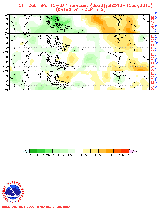
As I mentioned above, be careful about using that Emperical Wave Propagation chart. It's sort of like looking at a climo (CLP5) forecast of TC movement. Take a look at the link below and you'll see verification of all the forecasts (CFS, GFS and the EWP"). EWP doesn't verify well, as the atmosphere doesn't behave like a perfect wave system.

http://www.cpc.ncep.noaa.gov/products/p ... _chi.shtml

CFS is dry:
Image

As is the GFS:
Image
0 likes   

User avatar
cycloneye
Admin
Admin
Posts: 145328
Age: 68
Joined: Thu Oct 10, 2002 10:54 am
Location: San Juan, Puerto Rico

Re: Global Model Runs Discussion

#3996 Postby cycloneye » Mon Jul 23, 2012 7:55 am

:uarrow: Thank you 57 for the clarification about that.
0 likes   
Visit the Caribbean-Central America Weather Thread where you can find at first post web cams,radars
and observations from Caribbean basin members Click Here

User avatar
cycloneye
Admin
Admin
Posts: 145328
Age: 68
Joined: Thu Oct 10, 2002 10:54 am
Location: San Juan, Puerto Rico

Re: Global Model Runs Discussion

#3997 Postby cycloneye » Mon Jul 23, 2012 11:36 am

Maybe things start to pick up soon in Eastern Atlantic? The 12z GFS has a couple of lows in that area. After 192 hours both weaken,but is important to note the big high in place that would signal the tracks for future developments down the road if it persist during the peak of the season.

114 hours.

Image

144 hours.

Image

192 hours. Notice another strong wave with low emerging West Africa.

Image
0 likes   
Visit the Caribbean-Central America Weather Thread where you can find at first post web cams,radars
and observations from Caribbean basin members Click Here

User avatar
cycloneye
Admin
Admin
Posts: 145328
Age: 68
Joined: Thu Oct 10, 2002 10:54 am
Location: San Juan, Puerto Rico

Re: Global Model Runs Discussion

#3998 Postby cycloneye » Mon Jul 23, 2012 2:12 pm

The 12z ECMWF also shows the first wave that GFS has. Now we have to see consistency from both GFS and ECMWF in next runs to see if they continue to show this. ROCK,at least there is something on the models to look at :)

120 hours.

Image

168 hours.

Image

216 hours.

Image

240 hours.

Image
0 likes   
Visit the Caribbean-Central America Weather Thread where you can find at first post web cams,radars
and observations from Caribbean basin members Click Here

User avatar
Blown Away
S2K Supporter
S2K Supporter
Posts: 10146
Joined: Wed May 26, 2004 6:17 am

Re: Global Model Runs Discussion

#3999 Postby Blown Away » Mon Jul 23, 2012 4:53 pm

18z GFS has a low moving off Africa in 48 hours then moves across the Atlantic and is gone at 192 hours just E of the islands. A second low appears late in the run.
http://raleighwx.americanwx.com/models/ ... SLoop.html
0 likes   
Hurricane Eye Experience: David 79, Irene 99, Frances 04, Jeanne 04, Wilma 05... EYE COMING MY WAY IN 2024…
Hurricane Brush Experience: Andrew 92, Erin 95, Floyd 99, Matthew 16, Irma 17, Ian 22, Nicole 22…

User avatar
cycloneye
Admin
Admin
Posts: 145328
Age: 68
Joined: Thu Oct 10, 2002 10:54 am
Location: San Juan, Puerto Rico

Re: Global Model Runs Discussion

#4000 Postby cycloneye » Mon Jul 23, 2012 8:57 pm

The 00z package of the models will be important to see if they are going to be consistent with what they had at 12z ,18z by GFS, 12z from ECMWF and 12z,18z by NOGAPS.
0 likes   
Visit the Caribbean-Central America Weather Thread where you can find at first post web cams,radars
and observations from Caribbean basin members Click Here


Return to “2015”

Who is online

Users browsing this forum: No registered users and 10 guests