ATL: ERNESTO - Post-Tropical
Moderator: S2k Moderators

Re: ATL: FIVE - Tropical Depression
Is it just me, or does it look like TD5 is going more northwestward than westward in the last few satellite frames?
0 likes
"People might not get all they work for in this world, but they must certainly work for all they get."- Frederick Douglass
-
tolakram
- Admin

- Posts: 20179
- Age: 62
- Joined: Sun Aug 27, 2006 8:23 pm
- Location: Florence, KY (name is Mark)
Re: ATL: FIVE - Tropical Depression
Conditions appear to be rapidly improving.

0 likes
M a r k
- - - - -
Join us in chat: Storm2K Chatroom Invite. Android and IOS apps also available.
The posts in this forum are NOT official forecasts and should not be used as such. Posts are NOT endorsed by any professional institution or STORM2K.org. For official information and forecasts, please refer to NHC and NWS products.

Re: ATL: FIVE - Tropical Depression
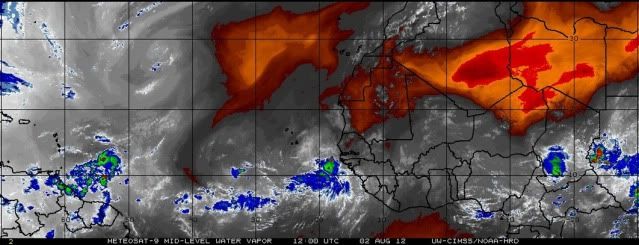
Convection getting hammered as TD5 runs into the sinking air of the ULL to its NW.
http://www.ssd.noaa.gov/PS/TROP/floater ... -long.html
http://www.ssd.noaa.gov/PS/TROP/floater ... -long.html
0 likes
-
Blown Away

- S2K Supporter

- Posts: 10253
- Joined: Wed May 26, 2004 6:17 am
Re: ATL: FIVE - Models
06z GFS, pretty significant swing to the north with landfall near TX/LA border. IMO, under 200 hours is the point where the GFS will start getting a general idea long range with regards to the strength of ridge. If the future GFS runs continue creeping right along the N Gulf coast then maybe there will be a breakdown of the ridge. Looking at the loop, TD5 does not look like it's moving 21 mph, maybe the building convection gives it the appearance of slowing down??
06z GFS at 204 hours:

06z GFS at 204 hours:
0 likes
Hurricane Eye Experience: David 79, Irene 99, Frances 04, Jeanne 04, Wilma 05… Hurricane Brush Experience: Andrew 92, Erin 95, Floyd 99, Matthew 16, Irma 17, Ian 22, Nicole 22…
-
tolakram
- Admin
- Posts: 20179
- Age: 62
- Joined: Sun Aug 27, 2006 8:23 pm
- Location: Florence, KY (name is Mark)
Re: ATL: FIVE - Tropical Depression
GCANE wrote:Convection getting hammered as TD5 runs into the sinking air of the ULL to its NW.
http://www.ssd.noaa.gov/PS/TROP/floater ... -long.html
I can't see the ULL you refer too.
0 likes
M a r k
- - - - -
Join us in chat: Storm2K Chatroom Invite. Android and IOS apps also available.
The posts in this forum are NOT official forecasts and should not be used as such. Posts are NOT endorsed by any professional institution or STORM2K.org. For official information and forecasts, please refer to NHC and NWS products.
- - - - -
Join us in chat: Storm2K Chatroom Invite. Android and IOS apps also available.
The posts in this forum are NOT official forecasts and should not be used as such. Posts are NOT endorsed by any professional institution or STORM2K.org. For official information and forecasts, please refer to NHC and NWS products.
-
Nederlander
- S2K Supporter
- Posts: 1259
- Joined: Sat Jul 19, 2008 4:28 pm
- Location: Conroe, TX
Re: ATL: FIVE - Tropical Depression
tolakram wrote:GCANE wrote:Convection getting hammered as TD5 runs into the sinking air of the ULL to its NW.
http://www.ssd.noaa.gov/PS/TROP/floater ... -long.html
I can't see the ULL you refer too.Doesn't mean it's not there, I just can't see it or don't know what to look for. What are you seeing?
I don't see it either.. I see a little dry air in the NW quadrant but that's about it.
0 likes
-
ozonepete
- Professional-Met

- Posts: 4743
- Joined: Mon Sep 07, 2009 3:23 pm
- Location: From Ozone Park, NYC / Now in Brooklyn, NY
Re: ATL: FIVE - Tropical Depression
0 likes
-
cycloneye

- Admin
- Posts: 149304
- Age: 69
- Joined: Thu Oct 10, 2002 10:54 am
- Location: San Juan, Puerto Rico
Re: ATL: FIVE - Tropical Depression
tolakram wrote:GCANE wrote:Convection getting hammered as TD5 runs into the sinking air of the ULL to its NW.
http://www.ssd.noaa.gov/PS/TROP/floater ... -long.html
I can't see the ULL you refer too.
It has to be miniscular in size as I also can't see it.
0 likes
Visit the Caribbean-Central America Weather Thread where you can find at first post web cams,radars
and observations from Caribbean basin members Click Here
and observations from Caribbean basin members Click Here
-
ozonepete
- Professional-Met
- Posts: 4743
- Joined: Mon Sep 07, 2009 3:23 pm
- Location: From Ozone Park, NYC / Now in Brooklyn, NY
Re: ATL: FIVE - Tropical Depression
tolakram wrote:GCANE wrote:Convection getting hammered as TD5 runs into the sinking air of the ULL to its NW.
http://www.ssd.noaa.gov/PS/TROP/floater ... -long.html
I can't see the ULL you refer too.
Hi GCANE. I don't see convection getting hammered at all. Still blowing up nicely over the center. Getting displaced a little to the east of center but not much...
0 likes
-
Nederlander
- S2K Supporter
- Posts: 1259
- Joined: Sat Jul 19, 2008 4:28 pm
- Location: Conroe, TX
Re: ATL: FIVE - Tropical Depression
AHS2011 wrote:Is it just me, or does it look like TD5 is going more northwestward than westward in the last few satellite frames?
Forecast track shows TD 5 should be gaining a little latitude so you could be right. Maybe a WNW heading starting to happen. Of course another possibility is your eyes playing tricks on you, which happens frequently. Wouldn't pay too much attention to wobbles frame to frame. I'm on my phone so I can't see loops.
0 likes
-
Gustywind

- Category 5

- Posts: 12334
- Joined: Mon Sep 03, 2007 7:29 am
- Location: Baie-Mahault, GUADELOUPE
Re: ATL: FIVE - Tropical Depression
Nederlander wrote:AHS2011 wrote:Is it just me, or does it look like TD5 is going more northwestward than westward in the last few satellite frames?
Forecast track shows TD 5 should be gaining a little latitude so you could be right. Maybe a WNW heading starting to happen. Of course another possibility is your eyes playing tricks on you, which happens frequently. Wouldn't pay too much attention to wobbles frame to frame. I'm on my phone so I can't see loops.
We will see as usual. Anyway, woobles or not an island from the Lesser Antilles could be threat by TD 5 if this feature continues to organize and moving towards the Eastern Carib.
0 likes
-
cycloneye
- Admin
- Posts: 149304
- Age: 69
- Joined: Thu Oct 10, 2002 10:54 am
- Location: San Juan, Puerto Rico
Re: ATL: FIVE - Tropical Depression
Here is this mornings discussion of TD Five by Dr Jeff Masters.
A disheveled Tropical Depression Five is clinging to life in the face of stiff wind shear and dry air, as the storm heads towards the Lesser Antilles Islands with a forward speed of 20 mph. The depression is very ragged looking on visible satellite loops. The depression has only a small area of heavy thunderstorms, which are on the south side of the center due to high wind shear and dry air on the northern side of the storm. Wind shear over TD 5 is at the moderate level, 15 - 20 knots. Water vapor satellite loops show that TD 5 is at the southern edge of a large area of dry air. Wind shear due to strong upper level winds from the west is driving this dry air into the core of the storm, disrupting it. The first Air Force hurricane hunter aircraft will investigate TD 5 Thursday afternoon to give us a better idea of its strength.
Forecast for TD 5
TD 5's west to west-northwest motion should bring its outer rain bands to Barbados early Friday morning, and high winds and heavy rain will spread over the rest of the Windward Islands by Friday afternoon. Since wind shear will be higher on the storm's north side, I expect the heaviest weather will be on the south side of TD 5, over the Windward Islands. Wind shear is expected to remain moderate, 10 - 20 knots, through Friday, according to the 8 am EDT run of the SHIPS model. However, the reliable ECMWF model predicts higher shear on Friday and Saturday, which could tear TD 5 apart. A number of our reliable computer models predict TD 5 will not survive its passage through the islands this weekend. However, most of the models agree that once TD 5 (or its remnants) pass enter the Central Caribbean on Monday, wind shear will fall to the low range, and strengthening (or regeneration) can occur. Once TD 5 enters the Western Caribbean between Jamaica and Mexico's Yucatan Peninsula, a trough of low pressure passing to the storm's north may be capable of turning TD 5 more to the northwest, resulting in the storm entering the Gulf of Mexico. An equally likely scenario at this point is that TD 5 will not turn, and instead will take a more westerly path over the Yucatan Peninsula. The long-term forecast for what the storm will do once it gets to the Western Caribbean depends upon whether or not TD 5 survives during the next two days.
http://www.wunderground.com/blog/JeffMa ... rynum=2168
0 likes
Visit the Caribbean-Central America Weather Thread where you can find at first post web cams,radars
and observations from Caribbean basin members Click Here
and observations from Caribbean basin members Click Here
Re: ATL: FIVE - Tropical Depression
ozonepete wrote:tolakram wrote:GCANE wrote:Convection getting hammered as TD5 runs into the sinking air of the ULL to its NW.
http://www.ssd.noaa.gov/PS/TROP/floater ... -long.html
I can't see the ULL you refer too.
Hi GCANE. I don't see convection getting hammered at all. Still blowing up nicely over the center. Getting displaced a little to the east of center but not much...
Scratch this - sorry for the mistake
Last edited by GCANE on Thu Aug 02, 2012 9:18 am, edited 1 time in total.
0 likes
Re: ATL: FIVE - Tropical Depression
GCANE wrote:ozonepete wrote:Hi GCANE. I don't see convection getting hammered at all. Still blowing up nicely over the center. Getting displaced a little to the east of center but not much...
Your right my mistake, I was looking at the wrong rotation.
I need another cup of coffee.
0 likes
Re: ATL: FIVE - Tropical Depression
Warmer tops but slightly better curved form. Wait until the next pulse to see how it rebounds.
0 likes

-
cycloneye
- Admin
- Posts: 149304
- Age: 69
- Joined: Thu Oct 10, 2002 10:54 am
- Location: San Juan, Puerto Rico
Re: ATL: FIVE - Recon Discussions - Comments - Questions
This is the TCPOD for Friday and Saturday.
WEATHER RECONNAISSANCE FLIGHTS
CARCAH, NATIONAL HURRICANE CENTER, MIAMI, FL.
1015 AM EDT THU 02 AUGUST 2012
SUBJECT: TROPICAL CYCLONE PLAN OF THE DAY (TCPOD)
VALID 03/1100Z TO 04/1100Z AUGUST 2012
TCPOD NUMBER.....12-076
I. ATLANTIC REQUIREMENTS
TD-05 FLIGHT ONE -- TEAL 72--
A. 03/1800Z-04/0000Z
B. AFXXX 0305A CYCLONE
C. 03/1630Z
D. 14.0N 61.6W
E. 03/1730Z TO 04/2030Z
F. SFC TO 10,000 FT
FLIGHT TWO -TEAL 70-
A. 04/0600, 1200Z
B. AFXXX 0405A CYCLONE
C. 04/0500Z
D. 14.6N 64.9W
E. 04/0530Z TO 04/1200Z
F. SFC TO 10,000 FT
2. OUTLOOK FOR SUCCEEDING DAY: CONTINUE 6-HRLY FIXES.
0 likes
Visit the Caribbean-Central America Weather Thread where you can find at first post web cams,radars
and observations from Caribbean basin members Click Here
and observations from Caribbean basin members Click Here

-
ozonepete
- Professional-Met
- Posts: 4743
- Joined: Mon Sep 07, 2009 3:23 pm
- Location: From Ozone Park, NYC / Now in Brooklyn, NY
Re: ATL: FIVE - Tropical Depression
GCANE wrote:GCANE wrote:ozonepete wrote:Hi GCANE. I don't see convection getting hammered at all. Still blowing up nicely over the center. Getting displaced a little to the east of center but not much...
Your right my mistake, I was looking at the wrong rotation.
I need another cup of coffee.
no harm no foul. just pretty rare to see you make a mistake so all of our antenna went up.
0 likes
-
Rgv20

- S2K Supporter
- Posts: 2466
- Age: 39
- Joined: Wed Jan 05, 2011 5:42 pm
- Location: Edinburg/McAllen Tx
0 likes
The following post is NOT an official forecast and should not be used as such. It is just the opinion of the poster and may or may not be backed by sound meteorological data. It is NOT endorsed by any professional institution including storm2k.org For Official Information please refer to the NHC and NWS products.
Who is online
Users browsing this forum: Google Adsense [Bot] and 65 guests