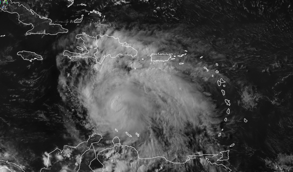
ATL: ERNESTO - Post-Tropical

Moderator: S2k Moderators

Message
Author
User avatar
Dave
Retired Staff
Retired Staff
Posts: 13442
Age: 74
Joined: Tue Aug 01, 2006 3:57 pm
Location: Milan Indiana
Contact:

Re:

#2521 Postby Dave » Sat Aug 04, 2012 4:28 pm

brunota2003 wrote:If you have a guess as to what Recon will find during their trip through Ernesto...then vote here:
viewtopic.php?f=25&t=113247

NOTE: This is the max wind speed that recon will find *at FLIGHT level* the entire mission! Not the first pass!

Post your guesses over there, so that we don't have 10 pages filled up on this thread of what you think they'll find :lol:

Mods: Can you set the poll to end at 7 pm? It only gave me a day option.


I don't see SG on so I think your stuck with 1 day. lol
0 likes   

ozonepete
Professional-Met
Professional-Met
Posts: 4743
Joined: Mon Sep 07, 2009 3:23 pm
Location: From Ozone Park, NYC / Now in Brooklyn, NY

Re: ATL: ERNESTO - Tropical Storm

#2522 Postby ozonepete » Sat Aug 04, 2012 4:29 pm

cycloneye wrote:The outflow is turning very good.

http://i300.photobucket.com/albums/nn39 ... -57-66.png


Luis, where'd you get that image? I love it.
0 likes   

User avatar
KWT
Category 5
Category 5
Posts: 31415
Joined: Tue Aug 17, 2004 11:02 am
Location: UK!!!

Re: ATL: ERNESTO - Tropical Storm

#2523 Postby KWT » Sat Aug 04, 2012 4:30 pm

RL3AO wrote:Also, I'm going to take a guess that recon finds a much weaker storm then some of you think. I bet they struggle to verify that 50kt intensity.


I think it'll have no problem being at 50kts providing the presentation keeps up where it is at the moment. That being said I also highly doubt its a hurricane at the moment. I'd go with 55kts at the moment.
0 likes   
Personal Forecast Disclaimer:
The posts in this forum are NOT official forecast and should not be used as such. They are just the opinion of the poster and may or may not be backed by sound meteorological data. They are NOT endorsed by any professional institution or storm2k.org. For official information, please refer to the NHC and NWS products

User avatar
MiamiHurricanes10
S2K Supporter
S2K Supporter
Posts: 260
Joined: Mon Jul 19, 2010 7:56 pm
Location: Miami, Florida

#2524 Postby MiamiHurricanes10 » Sat Aug 04, 2012 4:31 pm

Gorgeous cyclone.

Image

I believe Recon will find a hurricane -- but then again, my liberal bias is evident lol.
0 likes   

User avatar
Gustywind
Category 5
Category 5
Posts: 12334
Joined: Mon Sep 03, 2007 7:29 am
Location: Baie-Mahault, GUADELOUPE

Re: ATL: ERNESTO - Tropical Storm

#2525 Postby Gustywind » Sat Aug 04, 2012 4:31 pm

Annie Oakley wrote:Gusty.....thanks for that awesome graphic............

First be welcomed on this board ( :lol: you're not a newbie :cheesy: ), and second thanks to you :).
0 likes   

User avatar
cycloneye
Admin
Admin
Posts: 145864
Age: 69
Joined: Thu Oct 10, 2002 10:54 am
Location: San Juan, Puerto Rico

Re: Re:

#2526 Postby cycloneye » Sat Aug 04, 2012 4:31 pm

Dave wrote:
brunota2003 wrote:If you have a guess as to what Recon will find during their trip through Ernesto...then vote here:
viewtopic.php?f=25&t=113247

NOTE: This is the max wind speed that recon will find *at FLIGHT level* the entire mission! Not the first pass!

Post your guesses over there, so that we don't have 10 pages filled up on this thread of what you think they'll find :lol:

Mods: Can you set the poll to end at 7 pm? It only gave me a day option.


I don't see SG on so I think your stuck with 1 day. lol


There is no option for hours only :(
0 likes   
Visit the Caribbean-Central America Weather Thread where you can find at first post web cams,radars
and observations from Caribbean basin members Click Here

Weatherfreak000

Re: ATL: ERNESTO - Tropical Storm

#2527 Postby Weatherfreak000 » Sat Aug 04, 2012 4:33 pm

THAT my friends is on the cusp of hurricane status. The debate is over IMO, and STILL consistent with the GFDL.
0 likes   

User avatar
brunota2003
S2K Supporter
S2K Supporter
Posts: 9476
Age: 34
Joined: Sat Jul 30, 2005 9:56 pm
Location: Stanton, KY...formerly Havelock, NC
Contact:

#2528 Postby brunota2003 » Sat Aug 04, 2012 4:34 pm

Oh well :lol: I've never seen so much activity on the forecasting forum before though :cheesy:

Ernesto looks good at the moment, but convection was starting to wane. Will the convection be coming back over the next few hours, or is it going to nearly completely poof again?
0 likes   
Just a small town southern boy helping other humans.

User avatar
KWT
Category 5
Category 5
Posts: 31415
Joined: Tue Aug 17, 2004 11:02 am
Location: UK!!!

Re: ATL: ERNESTO - Tropical Storm

#2529 Postby KWT » Sat Aug 04, 2012 4:35 pm

AJC3 wrote:
HurricaneAndrew92 wrote:From satellite appearance, Ernie may well be a hurricane now, but you can't judge a book by its cover.


None of the satellite intensity estimates suggest this is the case. Neither does the microwave presentation.


Yep I agree. That being said the presentation of the IR imagery to my eye does kinda remind me of a 60-65kts system, but I don't think its quite as advanced as the presentation suggests.
0 likes   
Personal Forecast Disclaimer:
The posts in this forum are NOT official forecast and should not be used as such. They are just the opinion of the poster and may or may not be backed by sound meteorological data. They are NOT endorsed by any professional institution or storm2k.org. For official information, please refer to the NHC and NWS products

User avatar
Gustywind
Category 5
Category 5
Posts: 12334
Joined: Mon Sep 03, 2007 7:29 am
Location: Baie-Mahault, GUADELOUPE

#2530 Postby Gustywind » Sat Aug 04, 2012 4:35 pm

I wonder if many of us would have imagined such a situation for the beginning of August? :) What a change from June and July. This board has begun to find its his legendary enthusiasm :)
0 likes   

tolakram
Admin
Admin
Posts: 20020
Age: 62
Joined: Sun Aug 27, 2006 8:23 pm
Location: Florence, KY (name is Mark)

Re: ATL: ERNESTO - Tropical Storm

#2531 Postby tolakram » Sat Aug 04, 2012 4:38 pm

Man, my java based sat loops have been down all day, I'm lost. :)


Looking at the Atlantic wide view: http://www.ssd.noaa.gov/goes/east/tatl/flash-vis.html

Ernesto looks like a real storm now, rolling through the Caribbean, with Florence making a good show of it as well.

From earlier today

Image
0 likes   
M a r k
- - - - -
Join us in chat: Storm2K Chatroom Invite. Android and IOS apps also available.

The posts in this forum are NOT official forecasts and should not be used as such. Posts are NOT endorsed by any professional institution or STORM2K.org. For official information and forecasts, please refer to NHC and NWS products.

User avatar
AJC3
Admin
Admin
Posts: 4004
Age: 61
Joined: Tue Aug 31, 2004 7:04 pm
Location: Ballston Spa, New York
Contact:

Re: ATL: ERNESTO - Tropical Storm

#2532 Postby AJC3 » Sat Aug 04, 2012 4:38 pm

Weatherfreak000 wrote:THAT my friends is on the cusp of hurricane status. The debate is over IMO, and STILL consistent with the GFDL.


Honestly, I really don't see this as being the case. Looks like a moderate intensity tropical storm, as it's being called.
0 likes   

User avatar
Rgv20
S2K Supporter
S2K Supporter
Posts: 2466
Age: 39
Joined: Wed Jan 05, 2011 5:42 pm
Location: Edinburg/McAllen Tx

#2533 Postby Rgv20 » Sat Aug 04, 2012 4:38 pm

12zECMWF Ensemble Means are in excellent agreement with the operational ECMWF thru 96hrs (Wednesday Morning).

Image


Longer range it looks like some of the ECMWF Ensembles try to send Ernesto more North (North East Mexican Coast/South Texas) than the Operational Run

Image
0 likes   
The following post is NOT an official forecast and should not be used as such. It is just the opinion of the poster and may or may not be backed by sound meteorological data. It is NOT endorsed by any professional institution including storm2k.org For Official Information please refer to the NHC and NWS products.

User avatar
KWT
Category 5
Category 5
Posts: 31415
Joined: Tue Aug 17, 2004 11:02 am
Location: UK!!!

Re:

#2534 Postby KWT » Sat Aug 04, 2012 4:40 pm

brunota2003 wrote:Oh well :lol: I've never seen so much activity on the forecasting forum before though :cheesy:

Ernesto looks good at the moment, but convection was starting to wane. Will the convection be coming back over the next few hours, or is it going to nearly completely poof again?


That really is the big question. I'd say its highly likely that the convection will flare up again some point in the next 6-9hrs in a big way, the actual shape of the system is very good though thats for sure!
0 likes   
Personal Forecast Disclaimer:
The posts in this forum are NOT official forecast and should not be used as such. They are just the opinion of the poster and may or may not be backed by sound meteorological data. They are NOT endorsed by any professional institution or storm2k.org. For official information, please refer to the NHC and NWS products

User avatar
Gustywind
Category 5
Category 5
Posts: 12334
Joined: Mon Sep 03, 2007 7:29 am
Location: Baie-Mahault, GUADELOUPE

#2535 Postby Gustywind » Sat Aug 04, 2012 4:41 pm

How large this system is :eek: in spite of the convection who has waned a bit Ernesto could easily swim with shoulders like that... and be the leader of the Olympics swimming given its impressive size :lol:
Image
0 likes   

Shuriken

#2536 Postby Shuriken » Sat Aug 04, 2012 4:43 pm

This is just an incredible sat-shot depicting multiple layers of tops -- you see the standard cirrus overcast around most of the storm (figure 40kft that part of the subtropics), then a new convective blob overspreading that on the northern edge of the core (55kft?), and lastly the new post-diurnal core convection itself (70kft?), which is clearly going to overshoot everything else (and obscure via blow-off much of the other details in forthcoming imagery). So, a very cool pic at just the right time.

Image
Last edited by Shuriken on Sat Aug 04, 2012 4:45 pm, edited 1 time in total.
0 likes   

tolakram
Admin
Admin
Posts: 20020
Age: 62
Joined: Sun Aug 27, 2006 8:23 pm
Location: Florence, KY (name is Mark)

Re: ATL: ERNESTO - Tropical Storm

#2537 Postby tolakram » Sat Aug 04, 2012 4:44 pm

A couple of loops.

This infrared enhanced shows Ernesto still pulsing rather that maintaining deep convection.

Image

This visible loop show show much better Ernesto looked today, a giant ball rolling through the Caribbean.

http://www.esl.lsu.edu/imagery/atmosphe ... opics/VIS/
0 likes   
M a r k
- - - - -
Join us in chat: Storm2K Chatroom Invite. Android and IOS apps also available.

The posts in this forum are NOT official forecasts and should not be used as such. Posts are NOT endorsed by any professional institution or STORM2K.org. For official information and forecasts, please refer to NHC and NWS products.

Dean4Storms
S2K Supporter
S2K Supporter
Posts: 6358
Age: 62
Joined: Sun Aug 31, 2003 1:01 pm
Location: Miramar Bch. FL

#2538 Postby Dean4Storms » Sat Aug 04, 2012 4:47 pm

I have to say that I've seen much worse looking sheared Hurricanes in the past per Sat. Presentation. That said, that Dry Air is really killing it's eastern flank and I believe that to be what is slowing down the surface wind speeds. I think it might be 60mph right now, but not a hurricane with the dry air still affecting it.

I'm also wondering if the mountains of SA and the flow coming in off them is somewhat a culprit here?
0 likes   

User avatar
KWT
Category 5
Category 5
Posts: 31415
Joined: Tue Aug 17, 2004 11:02 am
Location: UK!!!

#2539 Postby KWT » Sat Aug 04, 2012 4:48 pm

The other thing to remember is that its inflow probably is being a little bit disrupted from SA, once it clears around 75W and the fetch from water becomes even larger I think that will help to reduce the plusing nature of the convection. The dry air to the west I think will stop it from really strengthening at a quick rate for the next 24-36hrs but after that I think we'll have lift-off.
0 likes   
Personal Forecast Disclaimer:
The posts in this forum are NOT official forecast and should not be used as such. They are just the opinion of the poster and may or may not be backed by sound meteorological data. They are NOT endorsed by any professional institution or storm2k.org. For official information, please refer to the NHC and NWS products

Caribwxgirl
S2K Supporter
S2K Supporter
Posts: 287
Joined: Mon Aug 15, 2011 7:25 pm
Location: Budapest, Hungary (from Kingston, Jamaica)

#2540 Postby Caribwxgirl » Sat Aug 04, 2012 4:49 pm

So what are the chances of this storm coming closer to Jamaica than the official track is predicting?
0 likes   
Personal Forecast Disclaimer:
The posts in this forum are NOT official forecast. They are just the opinion of the poster and may or may not be backed by sound meteorological data. They are NOT endorsed by any professional institutions or storm2k.org. For official information refer to the NHC and NWS products.


Return to “2012”

Who is online

Users browsing this forum: No registered users and 5 guests