ATL: ERNESTO - Post-Tropical

Moderator: S2k Moderators

Message
Author
User avatar
cycloneye
Admin
Admin
Posts: 145457
Age: 68
Joined: Thu Oct 10, 2002 10:54 am
Location: San Juan, Puerto Rico

Re: ATL: ERNESTO - Tropical Storm

#3601 Postby cycloneye » Mon Aug 06, 2012 8:39 am

RL3AO wrote:
HurricaneAndrew92 wrote:When would SA been posted?


Three options

1. Making a full forecast package takes 3.
2. They are communicating with goverments regarding new warnings.
3. They aren't going to issue a special.

3 is unlikely IMO. Probably a combo of the first two. I would assume they would have issued a TC update if they weren't in the process of creating a SA.


Also an hour before full advisory.
0 likes   
Visit the Caribbean-Central America Weather Thread where you can find at first post web cams,radars
and observations from Caribbean basin members Click Here

HurricaneAndrew92

Re: ATL: ERNESTO - Tropical Storm

#3602 Postby HurricaneAndrew92 » Mon Aug 06, 2012 8:40 am

RL3AO wrote:
HurricaneAndrew92 wrote:When would SA been posted?


Three options

1. Making a full forecast package takes 3.
2. They are communicating with goverments regarding new warnings.
3. They aren't going to issue a special.

3 is unlikely IMO. Probably a combo of the first two. I would assume they would have issued a TC update if they weren't in the process of creating a SA.

Ernesto, the storm that never dies! Somehow, watch this be an open wave tommorow.(based on past events!)
0 likes   

Sanibel
Category 5
Category 5
Posts: 10375
Joined: Mon Aug 30, 2004 11:06 pm
Location: Offshore SW Florida

Re: ATL: ERNESTO - Tropical Storm

#3603 Postby Sanibel » Mon Aug 06, 2012 8:40 am

I also see NW in the center movement reflected in the CDO. (I hope this isn't a crazy track change ala GFDL)
0 likes   

wxwatcher1999
Category 1
Category 1
Posts: 264
Joined: Sat Aug 04, 2012 10:19 am

Re: ATL: ERNESTO - Tropical Storm

#3604 Postby wxwatcher1999 » Mon Aug 06, 2012 8:41 am

Stormlover2012 wrote:nw movement could it be feeling the weakness?


If that's the case that could change everything
0 likes   
Personal Forecast Disclaimer:
The posts in this forum are NOT official forecast and should not be used as such. They are just the opinion of the poster and may or may not be backed by sound meteorological data. They are NOT endorsed by any professional institution or storm2k.org. For official information, please refer to the NHC and NWS products.

User avatar
'CaneFreak
Category 5
Category 5
Posts: 1486
Joined: Mon Jun 05, 2006 10:50 am
Location: New Bern, NC

Re:

#3605 Postby 'CaneFreak » Mon Aug 06, 2012 8:41 am

Now it looks like a mushroom cloud underneath the LLC...good grief this thing is shooting off like a rocket...

'CaneFreak wrote:http://www.ssd.noaa.gov/PS/TROP/floaters/05L/imagery/vis0-lalo.jpg

BEAUTIFUL CU tower just blew up over the center as of the 1245Z image...what I would give to be in that plane right now...
0 likes   

HurricaneAndrew92

Re: ATL: ERNESTO - Tropical Storm

#3606 Postby HurricaneAndrew92 » Mon Aug 06, 2012 8:42 am

wxwatcher1999 wrote:
Stormlover2012 wrote:nw movement could it be feeling the weakness?


If that's the case that could change everything

Well likely see a track change soon.
0 likes   

User avatar
AJC3
Admin
Admin
Posts: 3999
Age: 61
Joined: Tue Aug 31, 2004 7:04 pm
Location: Ballston Spa, New York
Contact:

Re: ATL: ERNESTO - Tropical Storm

#3607 Postby AJC3 » Mon Aug 06, 2012 8:42 am

Stormlover2012 wrote:nw movement could it be feeling the weakness?


Possibly, but could also be a function of consolidation. As it was mentioned earlier, we really need a few more center fixes to get a better feel.
0 likes   

RL3AO
Moderator-Pro Met
Moderator-Pro Met
Posts: 16308
Joined: Thu Jun 14, 2007 10:03 pm
Location: NC

#3608 Postby RL3AO » Mon Aug 06, 2012 8:43 am

Maybe they won't issue a special advisory as we are now only an hour away from 15z. However I'm surprised not to have seen a TCU yet.
0 likes   

User avatar
TexWx
Category 1
Category 1
Posts: 370
Joined: Tue Aug 22, 2006 11:00 pm
Location: Pearland, Texas
Contact:

#3609 Postby TexWx » Mon Aug 06, 2012 8:44 am

I just can't see Ernesto moving toward the weakness this far south.
0 likes   

User avatar
AJC3
Admin
Admin
Posts: 3999
Age: 61
Joined: Tue Aug 31, 2004 7:04 pm
Location: Ballston Spa, New York
Contact:

#3610 Postby AJC3 » Mon Aug 06, 2012 8:44 am

000
URNT15 KNHC 061340
AF302 0805A ERNESTO HDOB 30 20120806
133200 1623N 08050W 8432 01563 0102 +155 +149 093032 033 023 001 00
133230 1624N 08052W 8432 01564 0105 +152 +146 093032 033 023 001 00
133300 1625N 08053W 8427 01571 0106 +152 +145 091031 033 027 002 00
133330 1626N 08054W 8433 01562 0101 +159 +143 092031 032 023 002 00
133400 1628N 08056W 8432 01566 0101 +159 +143 086032 033 016 002 00
133430 1629N 08057W 8429 01567 0100 +160 +143 085032 033 018 001 00
133500 1630N 08058W 8429 01566 0099 +160 +144 084032 032 019 001 00
133530 1632N 08100W 8432 01564 0101 +158 +145 083031 032 012 002 00
133600 1633N 08101W 8432 01564 0100 +159 +146 084032 034 012 002 00
133630 1634N 08102W 8429 01569 0102 +158 +146 087031 035 010 002 00
133700 1635N 08104W 8429 01568 0100 +163 +147 094030 031 008 002 00
133730 1637N 08105W 8432 01567 0101 +161 +148 089029 030 009 000 00
133800 1638N 08106W 8428 01572 0103 +159 +149 089031 031 007 002 00
133830 1639N 08108W 8432 01566 0103 +156 +149 089032 033 001 001 00
133900 1641N 08109W 8431 01568 0105 +155 +149 090033 033 001 001 00
133930 1642N 08110W 8430 01571 0107 +155 +149 091033 034 002 001 00
134000 1643N 08112W 8429 01573 0108 +156 +149 092035 035 002 001 00
134030 1645N 08113W 8433 01569 0104 +162 +149 089033 034 001 001 00
134100 1646N 08115W 8433 01571 0107 +160 +149 089031 032 001 002 00
134130 1647N 08116W 8425 01579 0104 +167 +150 087030 031 001 001 00
$$
;
0 likes   

tolakram
Admin
Admin
Posts: 20012
Age: 62
Joined: Sun Aug 27, 2006 8:23 pm
Location: Florence, KY (name is Mark)

Re: ATL: ERNESTO - Tropical Storm

#3611 Postby tolakram » Mon Aug 06, 2012 8:45 am

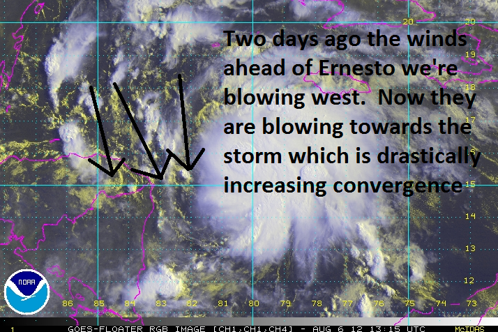
Latest

Image
0 likes   
M a r k
- - - - -
Join us in chat: Storm2K Chatroom Invite. Android and IOS apps also available.

The posts in this forum are NOT official forecasts and should not be used as such. Posts are NOT endorsed by any professional institution or STORM2K.org. For official information and forecasts, please refer to NHC and NWS products.

User avatar
AJC3
Admin
Admin
Posts: 3999
Age: 61
Joined: Tue Aug 31, 2004 7:04 pm
Location: Ballston Spa, New York
Contact:

Re: ATL: ERNESTO - Recon

#3612 Postby AJC3 » Mon Aug 06, 2012 8:46 am

Image
0 likes   

User avatar
tailgater
S2K Supporter
S2K Supporter
Posts: 3339
Joined: Sun Jul 11, 2004 9:13 pm
Location: St. Amant La.

Re: ATL: ERNESTO - Tropical Storm

#3613 Postby tailgater » Mon Aug 06, 2012 8:49 am

Might see an eye pop out soon. Looks much healthier at the surface now. check that, I see an outflow boundry shooting out to the NW on the NW edge of CDO.
Last edited by tailgater on Mon Aug 06, 2012 8:52 am, edited 1 time in total.
0 likes   
The following post is NOT an official forecast and should not be used as such. It is just the opinion of the poster and may or may not be backed by sound meteorological data. It is NOT endorsed by any professional institution including storm2k.org For Official Information please refer to the NHC and NWS products.

User avatar
artist
Category 5
Category 5
Posts: 9792
Joined: Mon Jun 06, 2005 3:26 pm
Location: West Palm

#3614 Postby artist » Mon Aug 06, 2012 8:50 am

the definition of RI from the NHC page-

Rapid Intensification:
An increase in the maximum sustained winds of a tropical cyclone of at least 30 kt in a 24-h period.

http://www.nhc.noaa.gov/aboutgloss.shtml
0 likes   

HurricaneAndrew92

Re: ATL: ERNESTO - Tropical Storm

#3615 Postby HurricaneAndrew92 » Mon Aug 06, 2012 8:51 am

hard to believe this is the same storm we were calling an open wave 12 hours ago.
0 likes   

User avatar
AJC3
Admin
Admin
Posts: 3999
Age: 61
Joined: Tue Aug 31, 2004 7:04 pm
Location: Ballston Spa, New York
Contact:

#3616 Postby AJC3 » Mon Aug 06, 2012 8:51 am

000
URNT12 KNHC 061344
VORTEX DATA MESSAGE AL052012
A. 06/13:17:00Z
B. 15 deg 43 min N
080 deg 10 min W
C. 850 mb 1381 m
D. 40 kt
E. 137 deg 3 nm
F. 235 deg 54 kt
G. 137 deg 3 nm
H. 994 mb
I. 17 C / 1538 m
J. 21 C / 1400 m
K. 15 C / NA
L. CLOSED WALL
M. C8

N. 12345 / 8
O. 0.02 / 1 nm
P. AF302 0805A ERNESTO OB 10
MAX FL WIND 55 KT E QUAD 12:05:30Z
MAX OUTBOUND FL WIND 77 KT NW QUAD 13:19:00Z
GOOD RADAR SIGNATURE
;
0 likes   

HurricaneAndrew92

Re:

#3617 Postby HurricaneAndrew92 » Mon Aug 06, 2012 8:51 am

artist wrote:the definition of RI from the NHC page-

Rapid Intensification:
An increase in the maximum sustained winds of a tropical cyclone of at least 30 kt in a 24-h period.

http://www.nhc.noaa.gov/aboutgloss.shtml

Already at least a 20kt change!
0 likes   

User avatar
AJC3
Admin
Admin
Posts: 3999
Age: 61
Joined: Tue Aug 31, 2004 7:04 pm
Location: Ballston Spa, New York
Contact:

#3618 Postby AJC3 » Mon Aug 06, 2012 8:55 am

000
URNT15 KNHC 061350
AF302 0805A ERNESTO HDOB 31 20120806
134200 1648N 08117W 8426 01578 0102 +172 +150 084032 033 001 001 00
134230 1650N 08119W 8433 01573 0103 +170 +151 085031 033 000 002 00
134300 1651N 08120W 8430 01575 0103 +170 +152 090027 030 000 002 00
134330 1652N 08121W 8431 01574 0104 +169 +153 095027 028 000 000 00
134400 1654N 08123W 8433 01572 0106 +165 +154 097029 030 001 001 00
134430 1655N 08124W 8430 01574 0108 +160 +154 097028 030 002 001 00
134500 1656N 08125W 8428 01578 0110 +160 +154 096029 029 001 001 00
134530 1657N 08127W 8432 01574 0110 +160 +153 096028 029 001 001 00
134600 1659N 08128W 8429 01577 0110 +160 +152 099027 027 006 001 00
134630 1700N 08129W 8431 01574 0109 +160 +151 098026 027 007 002 00
134700 1701N 08131W 8429 01578 0112 +160 +151 099026 028 009 001 03
134730 1702N 08133W 8422 01585 0114 +155 +151 093024 025 /// /// 03
134800 1700N 08133W 8436 01572 0114 +155 +152 093024 024 003 002 00
134830 1659N 08134W 8433 01574 0112 +158 +153 092025 025 007 001 00
134900 1657N 08134W 8426 01580 0112 +160 +152 090025 026 004 001 00
134930 1655N 08134W 8432 01575 0111 +160 +151 088025 026 001 003 00
135000 1654N 08134W 8432 01574 0110 +165 +149 088026 026 001 002 00
135030 1652N 08134W 8430 01577 0109 +164 +149 085022 025 003 001 00
135100 1650N 08135W 8430 01575 0113 +157 +148 079020 022 004 001 00
135130 1649N 08135W 8430 01575 0111 +157 +148 075019 019 007 001 00
$$
;
0 likes   

User avatar
AJC3
Admin
Admin
Posts: 3999
Age: 61
Joined: Tue Aug 31, 2004 7:04 pm
Location: Ballston Spa, New York
Contact:

Re: ATL: ERNESTO - Recon

#3619 Postby AJC3 » Mon Aug 06, 2012 8:56 am

Image
0 likes   

RL3AO
Moderator-Pro Met
Moderator-Pro Met
Posts: 16308
Joined: Thu Jun 14, 2007 10:03 pm
Location: NC

#3620 Postby RL3AO » Mon Aug 06, 2012 8:59 am

Image
0 likes   


Return to “2012”

Who is online

Users browsing this forum: No registered users and 4 guests