
ATL: HELENE - Post-Tropical
Moderator: S2k Moderators
-
tolakram
- Admin

- Posts: 20185
- Age: 62
- Joined: Sun Aug 27, 2006 8:23 pm
- Location: Florence, KY (name is Mark)
Re: ATL: SEVEN - Remnants
Saved visible loop
0 likes
M a r k
- - - - -
Join us in chat: Storm2K Chatroom Invite. Android and IOS apps also available.
The posts in this forum are NOT official forecasts and should not be used as such. Posts are NOT endorsed by any professional institution or STORM2K.org. For official information and forecasts, please refer to NHC and NWS products.
-
HouTXmetro

- Category 5

- Posts: 3949
- Joined: Sun Jun 13, 2004 6:00 pm
- Location: District of Columbia, USA
Let's say we do get a center or circulation and development, what are the chances of a stall and mainly northward motion. I'm hearing rumors of a front stalling near the Gulf coast in the coming days.
side note: convection looks discombobulated tonight.
side note: convection looks discombobulated tonight.
0 likes
[Disclaimer: My Amateur Opinion, please defer to your local authorities or the NHC for Guidance.]
-
vbhoutex

- Storm2k Executive
- Posts: 29149
- Age: 74
- Joined: Wed Oct 09, 2002 11:31 pm
- Location: Cypress, TX
- Contact:
Re: ATL: SEVEN - Remnants
According to NHC it is "remnants" of 7. So is the major vorticity just NW of the Yucatan a piece of the old wave axis? This is somewhat befuddling to me. One thing is for sure and that is that there is a HUGE amount of moisture coming NW off the Yucatan and BOC. I'll be a lot more interested in the morning if there are still banding features apparent and maybe a mid level coc. If this, whatever it becomes, combines with moisture coming in from the Pacific portions of Mexico and Texas could see some MAJOR rains in the nest several days.
0 likes
Skywarn, C.E.R.T.
Please click below to donate to STORM2K to help with the expenses of keeping the site going:

Please click below to donate to STORM2K to help with the expenses of keeping the site going:
-
Houstonia

- S2K Supporter

- Posts: 829
- Age: 61
- Joined: Fri Oct 11, 2002 9:45 am
- Location: Sharpstown, Houston, Harris County, Southeast Texas.
Re: ATL: SEVEN - Remnants
http://www.wunderground.com/modelmaps/maps.asp?model=GFS&domain=TA
Did I link that right?
If not - please help me!! I don't link many images!!
If so, am I looking at this right - the GFS shows the ... "system" meandering off the coast for days. Is that what I'm seeing?
Did I link that right?
If not - please help me!! I don't link many images!!
If so, am I looking at this right - the GFS shows the ... "system" meandering off the coast for days. Is that what I'm seeing?
0 likes
-
Portastorm

- Storm2k Moderator

- Posts: 9955
- Age: 63
- Joined: Fri Jul 11, 2003 9:16 am
- Location: Round Rock, TX
- Contact:
Re: ATL: SEVEN - Remnants
You did fine! The link works and the 18z GFS run to which you linked shows a meandering system just along the northeastern mainland Mexican coast ... just south of Brownsville. Most of the GFS runs from the last few days have been showing the same.
0 likes
Any forecasts under my name are to be taken with a grain of salt. Get your best forecasts from the National Weather Service and National Hurricane Center.
-
Rgv20

- S2K Supporter
- Posts: 2466
- Age: 39
- Joined: Wed Jan 05, 2011 5:42 pm
- Location: Edinburg/McAllen Tx
By Wednesday Morning the 0zGFS and 12zECMWF are identical in the placement of this possible Tropical Low...
12zECMWF
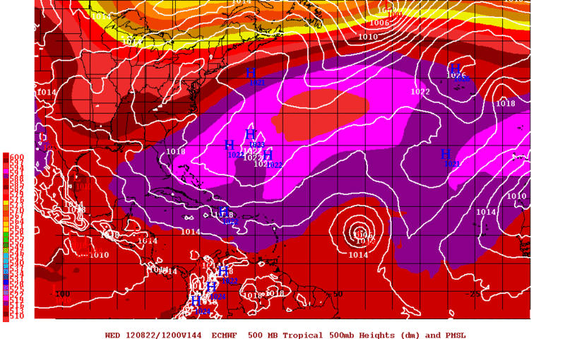
0zGFS
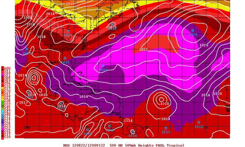
12zECMWF
0zGFS
0 likes
The following post is NOT an official forecast and should not be used as such. It is just the opinion of the poster and may or may not be backed by sound meteorological data. It is NOT endorsed by any professional institution including storm2k.org For Official Information please refer to the NHC and NWS products.

-
Rgv20
- S2K Supporter
- Posts: 2466
- Age: 39
- Joined: Wed Jan 05, 2011 5:42 pm
- Location: Edinburg/McAllen Tx
Re: ATL: SEVEN - Models
ROCK wrote:thats going to scoot up north.....look how the ridge retreats....
Actually on tonight's 0zGFS it moves WSW as the ridge builds back in to Texas and the ECMWF keeps the door open for Texas..
0 likes
The following post is NOT an official forecast and should not be used as such. It is just the opinion of the poster and may or may not be backed by sound meteorological data. It is NOT endorsed by any professional institution including storm2k.org For Official Information please refer to the NHC and NWS products.
-
Rgv20
- S2K Supporter
- Posts: 2466
- Age: 39
- Joined: Wed Jan 05, 2011 5:42 pm
- Location: Edinburg/McAllen Tx
0zGFS Ensemble Means are a tad more north with EX-TD7 and they have it making landfall just north of Brownsville by Thursday Morning.
0zGFS Ensemble Means forecast for Wednesday Morning..
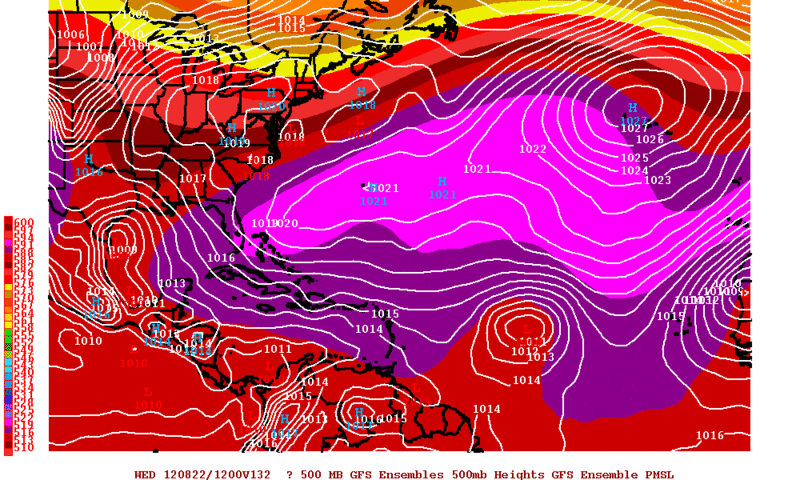
0zGFS Ensemble Means forecast for Wednesday Morning..
0 likes
The following post is NOT an official forecast and should not be used as such. It is just the opinion of the poster and may or may not be backed by sound meteorological data. It is NOT endorsed by any professional institution including storm2k.org For Official Information please refer to the NHC and NWS products.
Re: ATL: SEVEN - Models
the door is there but will it develope enough to take it....reminds me of Humberto.....
0 likes
-
Rgv20
- S2K Supporter
- Posts: 2466
- Age: 39
- Joined: Wed Jan 05, 2011 5:42 pm
- Location: Edinburg/McAllen Tx
The same time frame as the 0zGFS I posted above the 0zCMC also has a weak area of low pressure south of Brownsville...I think the HPC said it best...Regardless of development it looks like South Texas is in store for a very wet period starting late Sunday to early next week.
0zCMC forecast for Wednesday Morning..
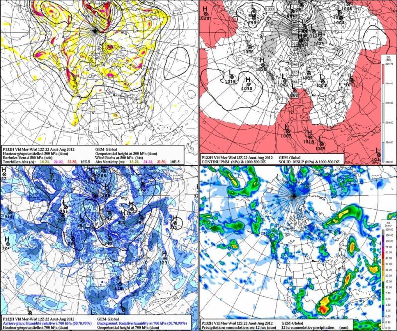
0zCMC forecast for Wednesday Morning..
0 likes
The following post is NOT an official forecast and should not be used as such. It is just the opinion of the poster and may or may not be backed by sound meteorological data. It is NOT endorsed by any professional institution including storm2k.org For Official Information please refer to the NHC and NWS products.
Re: ATL: SEVEN - Models
no doubt....STX is going to get hammered with a surge of moisture. A deeper system will trend further north...even developement further east could mean something more than just rain further up the coast....Watching things closely.
0 likes
-
cycloneye

- Admin
- Posts: 149481
- Age: 69
- Joined: Thu Oct 10, 2002 10:54 am
- Location: San Juan, Puerto Rico
Re: ATL: SEVEN - Remnants
THE REMNANTS OF TROPICAL DEPRESSION SEVEN CONTINUE TO SHOW SOME
SIGNS OF ORGANIZATION IN THE EXTREME SOUTHWESTERN GULF OF MEXICO.
ENVIRONMENTAL CONDITIONS APPEAR CONDUCIVE FOR SOME DEVELOPMENT
DURING THE NEXT DAY OR SO IF THE LOW STAYS OFFSHORE. THIS SYSTEM
HAS A MEDIUM CHANCE...40 PERCENT...OF BECOMING A TROPICAL CYCLONE
DURING THE NEXT 48 HOURS AS IT MOVES WEST-NORTHWESTWARD TO
NORTHWESTWARD AROUND 10 MPH. AN AIR FORCE RESERVE HURRICANE HUNTER
AIRCRAFT IS SCHEDULED TO INVESTIGATE THE LOW THIS AFTERNOON...IF
NECESSARY.
0 likes
Visit the Caribbean-Central America Weather Thread where you can find at first post web cams,radars
and observations from Caribbean basin members Click Here
and observations from Caribbean basin members Click Here
-
CYCLONE MIKE
- Category 5
- Posts: 2183
- Joined: Tue Aug 31, 2004 6:04 pm
- Location: Gonzales, LA
Re: ATL: SEVEN - Models
According to our latest forecast here in se la a front is supposed to make it down to the coast or even into the north gulf by Sunday into Monday. Correct me if I'm wrong but wouldn't that leave the door open for whatever may develop to move north or would hp be building back in by then?
0 likes
-
SETXWXLADY
- Tropical Storm

- Posts: 216
- Joined: Wed May 20, 2009 3:26 pm
- Location: SE TX Orange County
Re: ATL: SEVEN - Models
CYCLONE MIKE wrote:According to our latest forecast here in se la a front is supposed to make it down to the coast or even into the north gulf by Sunday into Monday. Correct me if I'm wrong but wouldn't that leave the door open for whatever may develop to move north or would hp be building back in by then?
Hope this is the right place to put this.
MODEL DIAGNOSTIC DISCUSSION
NWS HYDROMETEOROLOGICAL PREDICTION CENTER CAMP SPRINGS MD
223 AM EDT FRI AUG 17 2012
...TROPICAL WAVE OVER THE BAY OF CAMPECHE...
MODELS CLUSTER REASONABLY WELL IN ALLOWING THE REMNANTS OF TD
SEVEN TO STALL NEAR THE MEXICO COAST JUST SOUTH OF BROWNSVILLE
THIS WEEKEND WITH THE POTENTIAL TO STRENGTHEN AND POSSIBLY BECOME
ABSORBED BY AN UPPER TROUGH AFFECTING AREAS MAINLY EAST OF THE
MISSISSIPPI RIVER. REFER TO THE NHC FOR MORE INFORMATION.
0 likes
-
Pearl River

- S2K Supporter
- Posts: 825
- Age: 67
- Joined: Fri Dec 09, 2005 6:07 pm
- Location: SELa
Re: ATL: SEVEN - Remnants
From NOLA AFD:
.LONG TERM...
THE LONGWAVE TROUGH WILL CONTINUE TO DEEPEN AND MOVE EAST/
SOUTHEAST OVER EASTERN STATES AND LOWER MISSISSIPPI VALLEY SUNDAY
NIGHT INTO MONDAY BEFORE FLATTENING OUT TUESDAY INTO WEDNESDAY.
THE COLD FRONT IS EXPECTED TO SAG SOUTH...POSSIBLY REACHING NEAR
COASTAL SECTIONS...BUT THE MODEL CONSENSUS WOULD ARGUE FOR
STALLING THE FRONT JUST INLAND FROM THE COAST MONDAY NIGHT AND
TUESDAY MORNING. A GOOD CHANCE OF SHOWERS AND THUNDERSTORMS WILL
CONTINUE NEAR AND SOUTH OF THE FRONTAL BOUNDARY MONDAY WITH A
SLIGHTLY LOWER CHANCE ON TUESDAY AS SOME DRIER AIR WORKS IN FROM
THE NORTH. THE GFS HAS RETURNED TO HAVING A STRONGER TROPICAL LOW
PRESSURE SYSTEM DRIFTING NORTH ALONG THE NORTHEAST MEXICAN COAST
EARLY NEXT WEEK...BUT NEITHER THE OPERATIONAL GFS OR ECMWF BRING
THE SYSTEM AS FAR NORTH AS TEXAS. SEVERAL OF THE GFS ENSEMBLES DO
BRING THE LOW NORTH OR NORTHEAST TOWARDS TEXAS AND LOUISIANA...SO
WILL HAVE TO CONTINUE TO MONITOR THIS SYSTEM.
0 likes

Hmmm now upto 40%, looks like if it can stay offshore it has a shot at developing...even if does head inland it probably has enough time to at least redevelop back into a TD.
0 likes
Personal Forecast Disclaimer:
The posts in this forum are NOT official forecast and should not be used as such. They are just the opinion of the poster and may or may not be backed by sound meteorological data. They are NOT endorsed by any professional institution or storm2k.org. For official information, please refer to the NHC and NWS products
The posts in this forum are NOT official forecast and should not be used as such. They are just the opinion of the poster and may or may not be backed by sound meteorological data. They are NOT endorsed by any professional institution or storm2k.org. For official information, please refer to the NHC and NWS products

Re: ATL: SEVEN - Remnants
West winds to the south
http://www.ndbc.noaa.gov/station_page.php?station=sacv4
It seems to be moving WNW to NW. It may be onshore tomorrow at this rate...
http://www.ndbc.noaa.gov/station_page.php?station=sacv4
It seems to be moving WNW to NW. It may be onshore tomorrow at this rate...
0 likes

According to Mexican radar, the COC is already getting close to the Mexican coast, very well defined circulation may I add, I estimate it to be near 20.3N & 96W
It better start moving more north than west pretty soon otherwise it will be onshore later today.
http://smn.cna.gob.mx/radares/alvarado/alvarado.php
It better start moving more north than west pretty soon otherwise it will be onshore later today.
http://smn.cna.gob.mx/radares/alvarado/alvarado.php
0 likes
I do think it'll head inland, pattern should keep this heading westwards if this one continues to develop as it currently is.
Going to be a race against time again!!
Going to be a race against time again!!
0 likes
Personal Forecast Disclaimer:
The posts in this forum are NOT official forecast and should not be used as such. They are just the opinion of the poster and may or may not be backed by sound meteorological data. They are NOT endorsed by any professional institution or storm2k.org. For official information, please refer to the NHC and NWS products
The posts in this forum are NOT official forecast and should not be used as such. They are just the opinion of the poster and may or may not be backed by sound meteorological data. They are NOT endorsed by any professional institution or storm2k.org. For official information, please refer to the NHC and NWS products
Who is online
Users browsing this forum: No registered users and 59 guests