ATL: ISAAC - Models

Moderator: S2k Moderators

Message
Author
User avatar
deltadog03
Professional-Met
Professional-Met
Posts: 3580
Joined: Tue Jul 05, 2005 6:16 pm
Location: Macon, GA

Re: ATL: ISAAC - Models

#4021 Postby deltadog03 » Sat Aug 25, 2012 2:04 pm

PTrackerLA wrote:Looks like the 18z BAMs shifted west quite a bit towards Alabama and Mississippi. I don't know why the 12z GFS isn't updated on this map yet though. Does anyone think we'll see an adjustment in track at 5pm from the NHC based off the latest models? IMO they should shift the track a little closer to PNS.

http://www.sfwmd.gov/portal/page/portal/xweb%20weather/hurricane%20model%20plots


My **GUESS** is that they won't really do much with it...
0 likes   

User avatar
Evil Jeremy
S2K Supporter
S2K Supporter
Posts: 5463
Age: 32
Joined: Mon Apr 10, 2006 2:10 pm
Location: Los Angeles, CA

Re: ATL: ISAAC - Models

#4022 Postby Evil Jeremy » Sat Aug 25, 2012 2:16 pm

ROCK wrote:
Ivanhater wrote:Model roundup!

Today's 12Z runs:
Canadian - MSY
GEFS mean - MS coast
GFS - MS/AL border
GFDL and UK - Destin
ECMWF - PCB-AQQ


wheres the NOGAPS? MS/AL border.... :cheesy:


Does NOGAPS qualify as a "model" lol?
0 likes   
Frances 04 / Jeanne 04 / Katrina 05 / Wilma 05 / Fay 08 / Debby 12 / Andrea 13 / Colin 16 / Hermine 16 / Matthew 16 / Irma 17

nashrobertsx
Tropical Depression
Tropical Depression
Posts: 85
Joined: Fri Aug 15, 2008 3:55 pm

#4023 Postby nashrobertsx » Sat Aug 25, 2012 2:25 pm

Thanks Ivan (Michael).
Can you post a short list of the next model runs and what time they come out?
0 likes   

User avatar
Hurricane Andrew
S2K Supporter
S2K Supporter
Posts: 1891
Age: 26
Joined: Sun May 23, 2010 2:53 pm
Location: KS

Re:

#4024 Postby Hurricane Andrew » Sat Aug 25, 2012 2:27 pm

nashrobertsx wrote:Thanks Ivan (Michael).
Can you post a short list of the next model runs and what time they come out?

NAM: 3:30-4:30
GFS: 5:15-6:00
HWRF/GFDL: Shortly after GFS.
0 likes   

The Enthusiast
NREMT-AEMT, WX nerd

Irene '11, Sandy '12, Irma '17 (SAR)

"Hard to think we were born to live this way..." -Wage War

nashrobertsx
Tropical Depression
Tropical Depression
Posts: 85
Joined: Fri Aug 15, 2008 3:55 pm

#4025 Postby nashrobertsx » Sat Aug 25, 2012 2:32 pm

That's CDT or EDT?
Also, who has the latest spag plots map they can post from all this afternoon's models?
Thx
0 likes   

User avatar
southerngale
Retired Staff
Retired Staff
Posts: 27418
Joined: Thu Oct 10, 2002 1:27 am
Location: Southeast Texas (Beaumont area)

Re:

#4026 Postby southerngale » Sat Aug 25, 2012 2:41 pm

nashrobertsx wrote:That's CDT or EDT?
Also, who has the latest spag plots map they can post from all this afternoon's models?
Thx

EDT

This doesn't have all of the models.

Image
0 likes   
Please support Storm2k by making a donation today. It is greatly appreciated! Click here: Image

Image my Cowboys Image my RocketsImage my Astros

User avatar
Blinhart
Category 5
Category 5
Posts: 2081
Age: 48
Joined: Thu Sep 08, 2011 3:13 pm
Location: Crowley, La.

Re: ATL: ISAAC - Models

#4027 Postby Blinhart » Sat Aug 25, 2012 2:42 pm

http://icons-ak.wunderground.com/data/i ... smodel.gif

according to this the cone should shift to the West by a good 50 to 75 miles, and if this continues for the next couple days, it could end up being near Intercoastal City to Sabine Pass for final landfall.

This is starting to remind me of Rita and Ike.
0 likes   
Personal Forecast Disclaimer:
The posts in this forum are NOT official forecast and should not be used as such. They are just the opinion of the poster and may or may not be backed by sound meteorological data. They are NOT endorsed by any professional institution or storm2k.org. For official information, please refer to the NHC and NWS products.

User avatar
Ivanhater
Storm2k Moderator
Storm2k Moderator
Posts: 11162
Age: 38
Joined: Fri Jul 01, 2005 8:25 am
Location: Pensacola

Re: ATL: ISAAC - Models

#4028 Postby Ivanhater » Sat Aug 25, 2012 2:43 pm

GFS Ensembles are solidly west this afternoon in agreement with the operational GFS and last nights Euro ensembles and Euro Operational.

Euro Ensembles will be out shortly.

Image

Uploaded with ImageShack.us
0 likes   
Michael

User avatar
Hurricane Andrew
S2K Supporter
S2K Supporter
Posts: 1891
Age: 26
Joined: Sun May 23, 2010 2:53 pm
Location: KS

Re:

#4029 Postby Hurricane Andrew » Sat Aug 25, 2012 2:44 pm

nashrobertsx wrote:That's CDT or EDT?
Also, who has the latest spag plots map they can post from all this afternoon's models?
Thx

http://www.weatherbellmodels.com/weathe ... urrent.png
0 likes   

The Enthusiast
NREMT-AEMT, WX nerd

Irene '11, Sandy '12, Irma '17 (SAR)

"Hard to think we were born to live this way..." -Wage War

Senobia
Category 1
Category 1
Posts: 278
Joined: Sat Aug 05, 2006 2:59 pm
Location: Somewhere over the rainbow

Re: ATL: ISAAC - Models

#4030 Postby Senobia » Sat Aug 25, 2012 2:50 pm

Blinhart wrote:http://icons-ak.wunderground.com/data/images/at201209_ensmodel.gif

according to this the cone should shift to the West by a good 50 to 75 miles, and if this continues for the next couple days, it could end up being near Intercoastal City to Sabine Pass for final landfall.

This is starting to remind me of Rita and Ike.


:double: Hush that talk! :double:

The models will trend east....they will. They have to. :double:
0 likes   

User avatar
wxman57
Moderator-Pro Met
Moderator-Pro Met
Posts: 22981
Age: 67
Joined: Sat Jun 21, 2003 8:06 pm
Location: Houston, TX (southwest)

Re: ATL: ISAAC - Models

#4031 Postby wxman57 » Sat Aug 25, 2012 3:00 pm

Good model comparison page from Ryan Maue. Trend is a bit farther west with final landfall.

http://www.weatherbellmodels.com/weathe ... _mouse.php
0 likes   

User avatar
deltadog03
Professional-Met
Professional-Met
Posts: 3580
Joined: Tue Jul 05, 2005 6:16 pm
Location: Macon, GA

Re: ATL: ISAAC - Models

#4032 Postby deltadog03 » Sat Aug 25, 2012 3:02 pm

wxman57 wrote:Good model comparison page from Ryan Maue. Trend is a bit farther west with final landfall.

http://www.weatherbellmodels.com/weathe ... _mouse.php


How far are you thinking? I still think around PNS/PCB....What did you think of the Euro today?
0 likes   

User avatar
Ivanhater
Storm2k Moderator
Storm2k Moderator
Posts: 11162
Age: 38
Joined: Fri Jul 01, 2005 8:25 am
Location: Pensacola

Re: ATL: ISAAC - Models

#4033 Postby Ivanhater » Sat Aug 25, 2012 3:04 pm

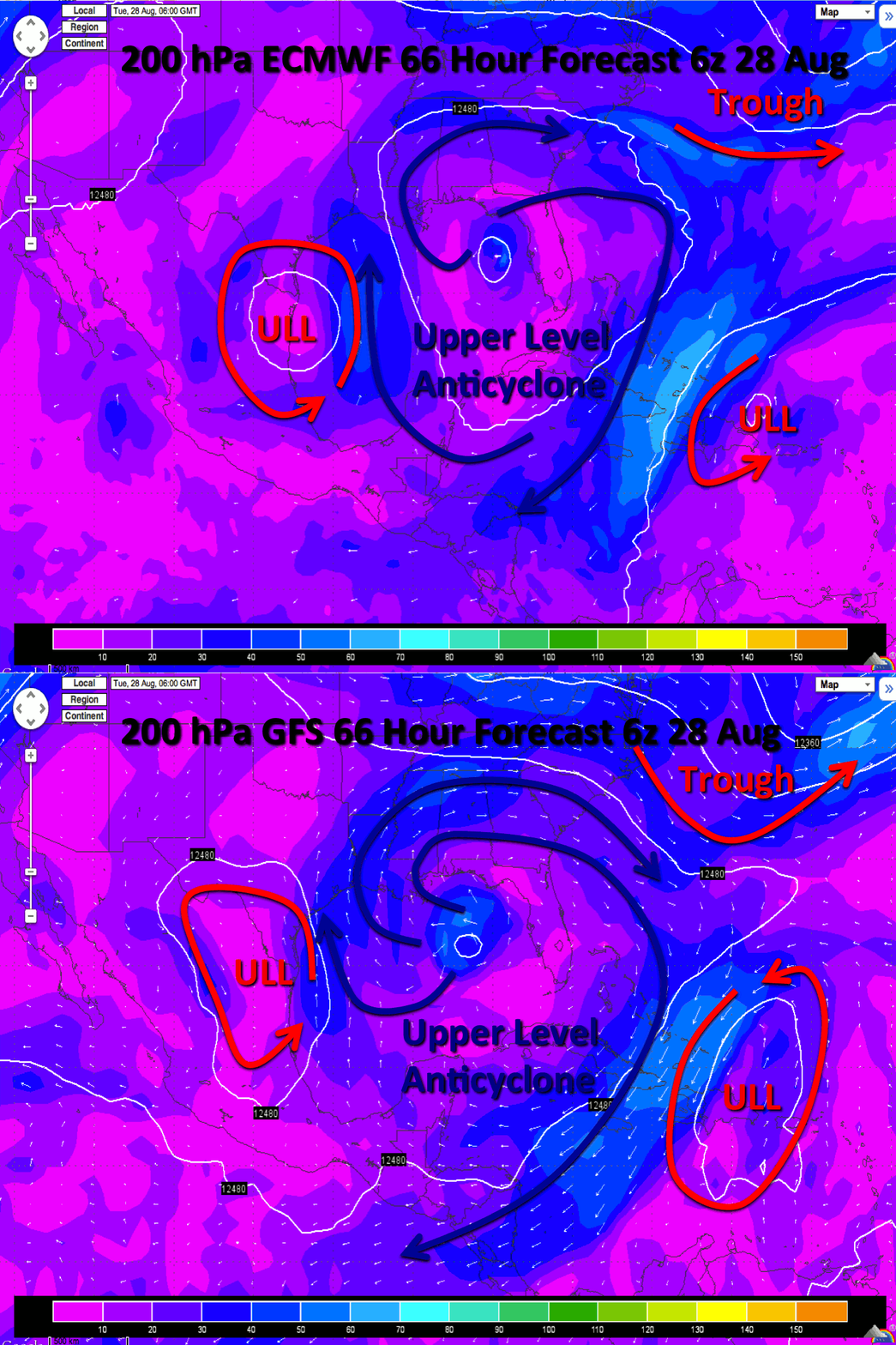
The upper level environment depicted by the GFS and Euro in the gulf look downright scary for this system. Ideal.
0 likes   
Michael

User avatar
ROCK
Category 5
Category 5
Posts: 9484
Age: 54
Joined: Tue Aug 17, 2004 7:30 am
Location: Kemah, Texas

Re: ATL: ISAAC - Models

#4034 Postby ROCK » Sat Aug 25, 2012 3:06 pm

ensembles spread out west again....like I said and I could be wrong...the EURO didnt do me any favors....Isaac is ejected NE way north by a zonal short wave in the GFS and NOGAPS, NAM etc....this is ridge driven and if the ridge builds in stronger than advertise then LA is not out of the question....so far though not much support....70% of storms miss right 30% miss left....this might be a 30 percenter...IMO


posts in this forum are NOT official forecast and should not be used as such. They are just the opinion of the poster and may or may not be backed by sound meteorological data. They are NOT endorsed by any professional institution or storm2k.org. For official information, please refer to the NHC and NWS products.
0 likes   

User avatar
Ixolib
Category 5
Category 5
Posts: 2741
Age: 68
Joined: Sun Aug 08, 2004 8:55 pm
Location: Biloxi, MS

Re: ATL: ISAAC - Models

#4035 Postby Ixolib » Sat Aug 25, 2012 3:07 pm

Ivanhater wrote:The upper level environment depicted by the GFS and Euro in the gulf look downright scary for this system. Ideal.


By "scary", do you mean RI scary, Katrina scary, or just general scary?

Apparently there's an anti-cyclone above, and hot water below. Upper and lower all look scary!!!
0 likes   
Betsy '65, Camille '69, Frederic '79, Elena '85, Georges '98, Isidore '02, Katrina '05, Isaac '12, Nate '17

WilmingtonSandbar
S2K Supporter
S2K Supporter
Posts: 505
Joined: Sun Aug 29, 2010 12:11 pm
Location: Southport, NC

Re: ATL: ISAAC - Models

#4036 Postby WilmingtonSandbar » Sat Aug 25, 2012 3:08 pm

[quote="wxman57"]Good model comparison page from Ryan Maue. Trend is a bit farther west with final landfall.

what is that that shoots up to SC?
0 likes   
Diana X2 (look it up), Bertha, Fran, Bonnie, Floyd, Dennis, Charley, Ophelia, Ernesto, Irene, Matthew, And Florence

User avatar
pgoss11
Category 2
Category 2
Posts: 702
Joined: Tue Sep 02, 2003 3:55 pm

Re: ATL: ISAAC - Models

#4037 Postby pgoss11 » Sat Aug 25, 2012 3:09 pm

WilmingtonSandbar wrote:
wxman57 wrote:Good model comparison page from Ryan Maue. Trend is a bit farther west with final landfall.

what is that that shoots up to SC?

Do you have link to this run?
0 likes   

User avatar
Ivanhater
Storm2k Moderator
Storm2k Moderator
Posts: 11162
Age: 38
Joined: Fri Jul 01, 2005 8:25 am
Location: Pensacola

Re: ATL: ISAAC - Models

#4038 Postby Ivanhater » Sat Aug 25, 2012 3:10 pm

Ixolib wrote:
Ivanhater wrote:The upper level environment depicted by the GFS and Euro in the gulf look downright scary for this system. Ideal.


By "scary", do you mean RI scary, Katrina scary, or just general scary?

Apparently there's an anti-cyclone above, and hot water below. Upper and lower all look scary!!!


Grabbed this from another site, but it shows the environment in the Gulf being ideal...

Image
0 likes   
Michael

WilmingtonSandbar
S2K Supporter
S2K Supporter
Posts: 505
Joined: Sun Aug 29, 2010 12:11 pm
Location: Southport, NC

Re: ATL: ISAAC - Models

#4039 Postby WilmingtonSandbar » Sat Aug 25, 2012 3:10 pm

pgoss11 wrote:
WilmingtonSandbar wrote:
wxman57 wrote:Good model comparison page from Ryan Maue. Trend is a bit farther west with final landfall.

what is that that shoots up to SC?

Do you have link to this run?


Sorry it was in Wxman57's original post and i deleted it for some reason.

http://www.weatherbellmodels.com/weathe ... _mouse.php
0 likes   
Diana X2 (look it up), Bertha, Fran, Bonnie, Floyd, Dennis, Charley, Ophelia, Ernesto, Irene, Matthew, And Florence

User avatar
pgoss11
Category 2
Category 2
Posts: 702
Joined: Tue Sep 02, 2003 3:55 pm

Re: ATL: ISAAC - Models

#4040 Postby pgoss11 » Sat Aug 25, 2012 3:13 pm

WilmingtonSandbar wrote:
wxman57 wrote:Good model comparison page from Ryan Maue. Trend is a bit farther west with final landfall.

what is that that shoots up to SC?

That model is the CLP5 model that goes to SC. Obviously an extreme right outlier
0 likes   


Return to “2012”

Who is online

Users browsing this forum: No registered users and 3 guests