ATL: SANDY - Remnants - Discussion

Moderator: S2k Moderators

Message
Author
User avatar
artist
Category 5
Category 5
Posts: 9792
Joined: Mon Jun 06, 2005 3:26 pm
Location: West Palm

Re:

#421 Postby artist » Wed Oct 24, 2012 7:49 am

brunota2003 wrote:You guys do realize that regardless of if Sandy makes landfall in SFL or stays offshore 100 miles, SFL is still going to get high winds and heavy rains, right? Along with potentially historic coastal waves of 25 to 30 feet (or greater), heavy beach erosion and possibly surge? A hurricane is NOT a point!

Just outside the coastal waters of Florida (this is for the Bahamas):

.THU NIGHT...HURRICANE CONDITIONS POSSIBLE. ATLC EXPOSURES...SE
WINDS 35 TO 40 KT...BECOMING S 50 TO 60 KT LATE.
ELSEWHERE...NE WINDS 60 TO 65 KT...BECOMING W TO NW 50 TO 60 KT
LATE. SEAS 21 TO 31 FT ATLC EXPOSURES...AND 16 TO
26 FT IN ELSEWHERE. SCATTERED TSTMS.
.FRI...TROPICAL STORM CONDITIONS POSSIBLE. W WINDS 55 TO 60 KT.
ATLC EXPOSURES...SEAS 26 FT...SUBSIDING TO 23 FT
LATE. ELSEWHERE...SEAS 16 TO 26 FT.

Florida coastal waters:

Thursday: Tropical storm conditions possible. Northeast winds 29 to 34 knots with gusts to around 50 knots. Along the coast... Seas 9 to 11 feet with occasional seas up to 14 feet building to 12 to 14 feet with occasional seas up to 18 feet in the afternoon. In the gulf stream...seas 11 to 13 feet with occasional seas up to 17 feet building to 13 to 15 feet with occasional seas up to 19 feet in the afternoon. Dominant period 9 seconds. North swell 3 feet increasing to 3 to 5 feet in the afternoon. Intracoastal waters rough. Chance of showers through the day. Slight chance of thunderstorms in the afternoon.

Thursday Night: Tropical storm conditions possible. North northwest winds 30 to 39 knots with gusts to around 55 knots. Seas 12 to 14 feet with occasional seas up to 18 feet along the coast and up to 16 to 20 feet with occasional up to 23 feet in the gulf stream. Dominant period 5 seconds. Intracoastal waters very rough. Showers likely and chance of thunderstorms.

Friday: Tropical storm conditions possible. Northwest winds 32 to 38 knots with gusts to around 55 knots. Seas 12 to 14 feet with occasional seas up to 18 feet along the coast and up to over 20 feet with occasional up to 27 feet in the gulf stream. Intracoastal waters very rough in exposed areas. Showers likely and chance of thunderstorms.

This was put out in the Marine Weather Discussion late last night:

VERY DANGEROUS SCENARIO IS DEVELOPING WITH SANDY AS SUFFICIENTLY SLOW MOVEMENT...PRE EXISTING HIGH SEAS...VERY LARGE WIND FIELD...AND ONSHORE FLOW DURING HIGH LUNAR TIDES COULD SPELL EXTREME COASTAL FLOODING AND EROSION FOR FLORIDA AND CERTAINLY BAHAMAS WED NIGHT THROUGH SAT. WW3 FORECASTING 12 FT SEAS TO REACH CENTRAL FLORIDA COAST BY 18Z THU WITH SEAS BUILDING 20-35 FT WITHIN THE COASTAL WATERS BY 18Z FRI. THIS COULD EVOLVE INTO A HISTORICAL EVENT AND FO'S ARE ENCOURAGED TO ADVERTISE THIS EVENT VERY HARD. NELY SWELL WILL CONTINUE TO IMPACT FLORIDA AND SE COASTS THROUGH THE WEEKEND WITH LONGER PERIOD SWELL INDUCING SUSTAINED RUNUP.

yeah, we still haven't dried out from Isaac here. I am concerned with what rains might come out of this for us.
0 likes   

User avatar
Bizzles
Category 1
Category 1
Posts: 472
Age: 39
Joined: Wed Oct 27, 2010 10:22 am
Location: Columbus, NJ

Re: ATL: SANDY - Tropical Storm - Discussion

#422 Postby Bizzles » Wed Oct 24, 2012 7:57 am

I'm flying into JAX early Saturday Morning then driving down to St. Augustine for a wedding on Sunday...

...then flying back to NJ (PHL) Monday night...i hope

Might get to see Sandy twice... :eek:
0 likes   
Andrew '92 Opal '95 Blizzard '96 Izzy '03 Irene '11 Sandy '12

The following post is NOT an official forecast and should not be used as such. It is just the opinion is not be backed by sound meteorological data. It is NOT endorsed by any professional institution including storm2k.org For Official Information please refer to the NHC and NWS products.

CrazyC83
Professional-Met
Professional-Met
Posts: 34002
Joined: Tue Mar 07, 2006 11:57 pm
Location: Deep South, for the first time!

Re: ATL: SANDY - Tropical Storm - Discussion

#423 Postby CrazyC83 » Wed Oct 24, 2012 7:57 am

Bizzles wrote:I'm flying into JAX early Saturday Morning then driving down to St. Augustine for a wedding on Sunday...

...then flying back to NJ (PHL) Monday night...i hope

Might get to see Sandy twice... :eek:


The flight will not happen if the storm is there, I can guarantee it.
0 likes   

User avatar
SouthDadeFish
Professional-Met
Professional-Met
Posts: 2835
Joined: Thu Sep 23, 2010 2:54 pm
Location: Miami, FL
Contact:

#424 Postby SouthDadeFish » Wed Oct 24, 2012 8:16 am

Sandy is poised to take off in intensity before land interaction slows her down.

Here is a recent SSMIS pass:

37 GHz Color:

Image

And here is 91 GHz Color:

Image

37 GHz shows more of the lower level structure while 91 GHz shows more of the mid-level structure, to put it roughly.
0 likes   

User avatar
gatorcane
S2K Supporter
S2K Supporter
Posts: 23691
Age: 47
Joined: Sun Mar 13, 2005 3:54 pm
Location: Boca Raton, FL

#425 Postby gatorcane » Wed Oct 24, 2012 8:17 am

The posts in this forum are NOT official forecast and should not be used as such. They are just the opinion of the poster and may or may not be backed by sound meteorological data. They are NOT endorsed by any professional institution or storm2k.org. For official information, please refer to the NHC and NWS products.


I think folks along the Florida East Coast may be underestimating the potential impact this system will have here. Normally systems that pass through the Bahamas to the east, are basically nonevents here. Maybe some nice breezes out of the NE but that is about it. This time the situation is different. Models are transitioning this system into a hybrid system that gets enhanced by some energy from a trough swinging through the Eastern United States as it moves north through the Bahamas. The windfield is going to expand bringing in potential tropical storm-forced sustained winds to the East Coast of Florida with higher gusts. The 00Z ECMWF brings very strong winds to the East Coast of Florida to near hurricane force along the coast. Plus, the system could take a track a bit more west than the model consensus is showing. Though the NOGAPs is not the best model for tracking these systems, it cannot be completely discounted and it has Sandy making landfall along the SE Florida coastline.
Last edited by gatorcane on Wed Oct 24, 2012 8:21 am, edited 1 time in total.
0 likes   

User avatar
msbee
S2K Supporter
S2K Supporter
Posts: 3027
Joined: Wed Jun 11, 2003 10:11 am
Location: St. Maarten

Re: ATL: SANDY - Tropical Storm - Discussion

#426 Postby msbee » Wed Oct 24, 2012 8:21 am

Brian Norcross Blog this morning:

http://www.wunderground.com/blog/bnorcr ... ntrynum=16

Threat of Northeast Effects from Sandy
Posted by: Bryan Norcross, 2:00 AM GMT on October 24, 2012 +8
Wow... what an extraordinarily unusual scenario. What seemed like a fluke of an idea - a hurricane-like system hitting the northeastern U.S. - is gaining credibility. Originally the European model was on its own with the spectacular but somewhat bizarre idea that Sandy would be injected with jet stream energy and curve back toward New England as a stunningly strong storm. Now one model after the other, including the ensembles, are favoring a swing back toward the East Coast after the storm goes by Cape Hatteras.

This the the afternoon run of the American GFS model ensembles - multiple lower-resolution runs with slightly different initial information, which allows for the fact that we can't measure the atmosphere precisely among other things.


The majority of the possible tracks now head into the Northeast, New England, or Atlantic Canada.

Could it really be a strong hurricane, as the European model predicts? We know that, occasionally, hurricanes do occur at these high latitudes at the end of October. Famously, the "Perfect Storm", otherwise known as the Halloween Hurricane battered New England in 1991. Also, Category 2 Hurricane Ginny hit Nova Scotia in late October 1963. But, neither were of a scale and impact like the Euro is showing.

With the influence of the jet stream, you would think any storm that comes ashore would be subtropical in nature - part tropical and part like a nor'easter - but the NHC doesn't allow for subtropical hurricanes in their naming scheme. It's considered to be such a rare and nearly impossible event.

The spectacularly unusual confluence of events is the shape and orientation of the dip in the jet stream that is forecast to develop over eastern North America over the weekend - oriented in such a way to pull Sandy inland instead of pushing it out to sea, and the presence of a strong tropical or subtropical system where it can get pulled in. That's so bizarrely unusual that I can't think of another event like it.

This kind of thing occasionally happens with nor'easters, notably the Great Appalachian Storm of November 1950 which curved in off the Atlantic and dumped 20 to 30 inches of snow over a wide area in the Mid-Atlantic and Midwest, but the odds of it happening with a system that originated in the tropics - with all of the moisture that that implies - are extremely low.

We certainly don't know that it's going to happen, and our concern at the moment is for our friends in the Caribbean and the Bahamas who will take a direct hit from a strengthening hurricane. The Florida and Carolina coasts also need to be ready to take protective action - especially boaters and people right at the coast - depending on the track Thursday to Saturday. But it's not often that credible forecast models consistently forecast a historic event, and with more models leaning that way, we need to be aware and pay attention along the entire U.S. East Coast.
0 likes   
Too many hurricanes to remember

User avatar
GCANE
S2K Supporter
S2K Supporter
Posts: 11496
Joined: Mon Oct 22, 2007 8:03 am

Re: ATL: SANDY - Tropical Storm - Discussion

#427 Postby GCANE » Wed Oct 24, 2012 8:22 am

Persistent VHT has brought the anti-cyclone over the LLC

http://tropic.ssec.wisc.edu/real-time/s ... 000&loop=0
0 likes   

wjs3
S2K Supporter
S2K Supporter
Posts: 633
Joined: Sat Aug 14, 2004 7:57 am

#428 Postby wjs3 » Wed Oct 24, 2012 8:24 am

That is one impressive SSMI pass.
0 likes   

User avatar
boca
Category 5
Category 5
Posts: 6367
Age: 60
Joined: Mon Dec 15, 2003 8:49 am
Location: Boca Raton,FL

Re: ATL: SANDY - Tropical Storm - Discussion

#429 Postby boca » Wed Oct 24, 2012 8:25 am

What would cause Sandy to possibly move NNW once its north of Cuba?
0 likes   

Frank2
Category 5
Category 5
Posts: 4061
Joined: Mon Jul 25, 2005 12:47 pm

Re: ATL: SANDY - Tropical Storm - Discussion

#430 Postby Frank2 » Wed Oct 24, 2012 8:28 am

Gatorcane,

I don't agree - TWC mentioned this morning that Sandy is a "right handed storm", so don't expect too much as it passes South Florida, especially if it continues on it's current 010 or 020 heading because it'll be somewhere between 76.0 and 75.0 once it passes our latitude - or between 400 and 500 miles east of here, and while the wind field is forecast to expand, it's currently increasing forward speed and that is a good indicator that it may move out of our area (and out to sea) before the trough interacts with it - just my opinion, but definitely it's increasing forward speed means that it's caught in a pretty strong existing trough (not the one forecast to approach it from the west)...

Frank
Last edited by Frank2 on Wed Oct 24, 2012 8:34 am, edited 2 times in total.
0 likes   

Aric Dunn
Category 5
Category 5
Posts: 21238
Age: 42
Joined: Sun Sep 19, 2004 9:58 pm
Location: Ready for the Chase.
Contact:

#431 Postby Aric Dunn » Wed Oct 24, 2012 8:30 am

Looks like on visible and eye may be starting to clear out..
0 likes   
Note: If I make a post that is brief. Please refer back to previous posts for the analysis or reasoning. I do not re-write/qoute what my initial post said each time.
If there is nothing before... then just ask :)

Space & Atmospheric Physicist, Embry-Riddle Aeronautical University,
I believe the sky is falling...

User avatar
gatorcane
S2K Supporter
S2K Supporter
Posts: 23691
Age: 47
Joined: Sun Mar 13, 2005 3:54 pm
Location: Boca Raton, FL

#432 Postby gatorcane » Wed Oct 24, 2012 8:30 am

Frank I see more of a due north movement now, will be interesting to see what the 11AM EST advisory says as far as the movement. Definitely not as NNE as yesterday.
Last edited by gatorcane on Wed Oct 24, 2012 8:30 am, edited 1 time in total.
0 likes   

User avatar
AdamFirst
S2K Supporter
S2K Supporter
Posts: 2491
Age: 36
Joined: Thu Aug 14, 2008 10:54 am
Location: Port Saint Lucie, FL

Re: ATL: SANDY - Tropical Storm - Discussion

#433 Postby AdamFirst » Wed Oct 24, 2012 8:30 am

Frank2 wrote:TWC mentioned this morning that Sandy is a "right handed storm", so don't expect too much as it passes South Florida, especially if it continues on it's current 010 or 020 heading...

Frank


TWC being the TWC again, since multiple models are calling for the storm to expand as it merges with the trough. 00z EURO has 60-knot winds along the east coast of Florida in a little over 48 hours, for example.


Personal Forecast Disclaimer:
The posts in this forum are NOT official forecast and should not be used as such. They are just the opinion of the poster and may or may not be backed by sound meteorological data. They are NOT endorsed by any professional institution or storm2k.org. For official information, please refer to the NHC and NWS products.
0 likes   
Dolphins Marlins Canes Golden Panthers HEAT
Andrew 1992 - Irene 1999 - Frances 2004 - Jeanne 2004 - Wilma 2005 - Fay 2008 - Isaac 2012 - Matthew 2016 - Irma 2017 - Dorian 2019 - Ian 2022 - Nicole 2022 - Milton 2024

User avatar
boca
Category 5
Category 5
Posts: 6367
Age: 60
Joined: Mon Dec 15, 2003 8:49 am
Location: Boca Raton,FL

Re: ATL: SANDY - Tropical Storm - Discussion

#434 Postby boca » Wed Oct 24, 2012 8:31 am

It would have to turn NNW to effect South Florida other than wind
0 likes   

User avatar
brunota2003
S2K Supporter
S2K Supporter
Posts: 9476
Age: 34
Joined: Sat Jul 30, 2005 9:56 pm
Location: Stanton, KY...formerly Havelock, NC
Contact:

Re: ATL: SANDY - Tropical Storm - Discussion

#435 Postby brunota2003 » Wed Oct 24, 2012 8:32 am

Frank2 wrote:TWC mentioned this morning that Sandy is a "right handed storm", so don't expect too much as it passes South Florida, especially if it continues on it's current 010 or 020 heading...

Frank

This morning, the majority of the heavy storms are on the west side, though?
0 likes   
Just a small town southern boy helping other humans.

Frank2
Category 5
Category 5
Posts: 4061
Joined: Mon Jul 25, 2005 12:47 pm

#436 Postby Frank2 » Wed Oct 24, 2012 8:38 am

No, just close to the center on the west side - the very large area of precip is all to the northeast through southeast and well east of the center...

P.S. Per some of these wild scenarios of Sandy making landfall near NYC - TWC also mentioned that it seems the GFS solution is more likely (out to sea)...
Last edited by Frank2 on Wed Oct 24, 2012 8:43 am, edited 1 time in total.
0 likes   

User avatar
AdamFirst
S2K Supporter
S2K Supporter
Posts: 2491
Age: 36
Joined: Thu Aug 14, 2008 10:54 am
Location: Port Saint Lucie, FL

Re: ATL: SANDY - Tropical Storm - Discussion

#437 Postby AdamFirst » Wed Oct 24, 2012 8:42 am

From this morning's AFD from Melbourne

BASED ON COORDINATION WITH THE NATIONAL HURRICANE CENTER...A
TROPICAL STORM WATCH IS INCREASINGLY LIKELY ALONG PORTIONS OF
THE SPACE AND TREASURE COASTS LATER THIS MORNING.
0 likes   
Dolphins Marlins Canes Golden Panthers HEAT
Andrew 1992 - Irene 1999 - Frances 2004 - Jeanne 2004 - Wilma 2005 - Fay 2008 - Isaac 2012 - Matthew 2016 - Irma 2017 - Dorian 2019 - Ian 2022 - Nicole 2022 - Milton 2024

User avatar
boca
Category 5
Category 5
Posts: 6367
Age: 60
Joined: Mon Dec 15, 2003 8:49 am
Location: Boca Raton,FL

Re: ATL: SANDY - Tropical Storm - Discussion

#438 Postby boca » Wed Oct 24, 2012 8:43 am

Im going to agree with Frank2 we wont get the rain from it,we will get 40 mph winds,but I think thats it out of Sandy as far as South Florida is concerned.
0 likes   

User avatar
SouthDadeFish
Professional-Met
Professional-Met
Posts: 2835
Joined: Thu Sep 23, 2010 2:54 pm
Location: Miami, FL
Contact:

#439 Postby SouthDadeFish » Wed Oct 24, 2012 8:43 am

Recon just found a 4mb pressure drop between fixes....
0 likes   

ozonepete
Professional-Met
Professional-Met
Posts: 4743
Joined: Mon Sep 07, 2009 3:23 pm
Location: From Ozone Park, NYC / Now in Brooklyn, NY

Re: ATL: SANDY - Tropical Storm - Discussion

#440 Postby ozonepete » Wed Oct 24, 2012 8:44 am

boca wrote:It would have to turn NNW to effect South Florida other than wind


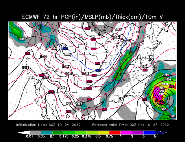
00Z Euro precipitation forecast for 72 hours out:

Image
0 likes   


Return to “2012”

Who is online

Users browsing this forum: No registered users and 1 guest