Expert forecasts for 2013 N Atlantic season

This is the general tropical discussion area. Anyone can take their shot at predicting a storms path.

Moderator: S2k Moderators

Forum rules

The posts in this forum are NOT official forecasts and should not be used as such. They are just the opinion of the poster and may or may not be backed by sound meteorological data. They are NOT endorsed by any professional institution or STORM2K. For official information, please refer to products from the National Hurricane Center and National Weather Service.

Help Support Storm2K
Message
Author
psyclone
S2K Supporter
S2K Supporter
Posts: 4762
Joined: Wed Aug 24, 2005 9:04 pm
Location: palm harbor fl

Re: Expert forecasts for 2013 N.Atlantic season (See 1st post)

#61 Postby psyclone » Mon Mar 25, 2013 9:12 pm

wxman57 wrote:
SFLcane wrote:So were are your season numbers or predictions 57 ? :0)


I'm thinking 15-18 NS, 6-8 H and 3-4 IH. Neutral ENSO. Weaker Bermuda High. Pressures closer to normal in the MDR/Caribbean/Gulf. Warmer SSTs in the MDR. Less low-level wind shear in the Tropical Atlantic and Caribbean. Less dry/sinking air (more instability). Negative NAO may turn systems northward that track north of the Caribbean vs. into the East Coast. Decreased threat of an East Coast hurricane impact (vs. normal). Significantly higher risk of a hurricane striking the eastern Caribbean this year vs. 2012. Higher risk of a major hurricane in the Gulf (than 2012).

Yikes. that is a spicy early hunch.
0 likes   

User avatar
cycloneye
Admin
Admin
Posts: 145318
Age: 68
Joined: Thu Oct 10, 2002 10:54 am
Location: San Juan, Puerto Rico

Re: Expert forecasts for 2013 N Atlantic season (See 1st post)

#62 Postby cycloneye » Tue Mar 26, 2013 5:47 am

Joe Bastardi's December outlook is posted at the first post list. (Between 13-17 named storms) Let''s see when he will release his next outlook.
0 likes   
Visit the Caribbean-Central America Weather Thread where you can find at first post web cams,radars
and observations from Caribbean basin members Click Here

User avatar
Blown Away
S2K Supporter
S2K Supporter
Posts: 10145
Joined: Wed May 26, 2004 6:17 am

Re: Expert forecasts for 2013 N Atlantic season (See 1st post)

#63 Postby Blown Away » Tue Mar 26, 2013 12:01 pm

cycloneye wrote:Joe Bastardi's December outlook is posted at the first post list. (Between 13-17 named storms) Let''s see when he will release his next outlook.


Image

Graphic for JB's December outlook.
0 likes   
Hurricane Eye Experience: David 79, Irene 99, Frances 04, Jeanne 04, Wilma 05... EYE COMING MY WAY IN 2024…
Hurricane Brush Experience: Andrew 92, Erin 95, Floyd 99, Matthew 16, Irma 17, Ian 22, Nicole 22…

User avatar
gatorcane
S2K Supporter
S2K Supporter
Posts: 23691
Age: 47
Joined: Sun Mar 13, 2005 3:54 pm
Location: Boca Raton, FL

#64 Postby gatorcane » Tue Mar 26, 2013 4:23 pm

I am no expert, but with neutral conditions expected and above normal SSTs a good possibility across the Atlantic basin and MDR, I am leaning towards an active season also with more major hurricanes due do less sinking and stable air than we saw last year.
0 likes   

User avatar
cycloneye
Admin
Admin
Posts: 145318
Age: 68
Joined: Thu Oct 10, 2002 10:54 am
Location: San Juan, Puerto Rico

Re: Expert forecasts for 2013 N Atlantic season (See 1st post)

#65 Postby cycloneye » Thu Mar 28, 2013 11:33 am

A preview of what Dr Phil Klotzbach / Dr Willam Gray will have on the April 10th forecast is posted at the first post. It looks like we may have to fasten our seatbelts. :eek:

See first post list
0 likes   
Visit the Caribbean-Central America Weather Thread where you can find at first post web cams,radars
and observations from Caribbean basin members Click Here

User avatar
Riptide
Category 2
Category 2
Posts: 753
Age: 34
Joined: Fri Jul 23, 2010 3:33 pm
Location: Cape May, New Jersey
Contact:

Re: Expert forecasts for 2013 N Atlantic season (See 1st post)

#66 Postby Riptide » Thu Mar 28, 2013 1:11 pm

Supposedly Bill Gray and Phil Klotzbach will be at the National Hurricane Conference in New Orleans and will release their forecast today, according to the website schedule.
0 likes   

User avatar
TropicalAnalystwx13
Category 5
Category 5
Posts: 2109
Age: 27
Joined: Tue Jul 19, 2011 8:20 pm
Location: Wilmington, NC
Contact:

#67 Postby TropicalAnalystwx13 » Thu Mar 28, 2013 8:13 pm

I'm not going to directly post Joe Bastardi's forecast because as far as I'm aware it's not legal if you haven't paid for the site. I'll summarize instead:

- The season is going to be bad. You can infer his opinion of that by just reading the title, "Welcome to my nightmare-the 2013 hurricane season"

- His updated forecast is for 16 named storms, 12 hurricanes, and 5 major hurricanes.

- ACE index of 165

- Many hits along the East Coast. He states the major hurricane landfall drought is LIKELY to come to end this year, and the USA may actually be hit by several majors.

- Pattern is comparable to 2005 and the 1950s.
0 likes   

User avatar
cycloneye
Admin
Admin
Posts: 145318
Age: 68
Joined: Thu Oct 10, 2002 10:54 am
Location: San Juan, Puerto Rico

Re: Expert forecasts for 2013 N Atlantic season (See 1st post)

#68 Postby cycloneye » Thu Mar 28, 2013 8:27 pm

:uarrow: I added the JB forecast to the first post list. I put the Weatherbell link if anyone wants to register there.
0 likes   
Visit the Caribbean-Central America Weather Thread where you can find at first post web cams,radars
and observations from Caribbean basin members Click Here

User avatar
cycloneye
Admin
Admin
Posts: 145318
Age: 68
Joined: Thu Oct 10, 2002 10:54 am
Location: San Juan, Puerto Rico

Re: Expert forecasts for 2013 season= JB is up (See 1st post)

#69 Postby cycloneye » Thu Mar 28, 2013 8:50 pm

Impact Weather late March forecast is up at first post list
0 likes   
Visit the Caribbean-Central America Weather Thread where you can find at first post web cams,radars
and observations from Caribbean basin members Click Here

User avatar
wxman57
Moderator-Pro Met
Moderator-Pro Met
Posts: 22978
Age: 67
Joined: Sat Jun 21, 2003 8:06 pm
Location: Houston, TX (southwest)

Re: Expert forecasts for 2013 N Atlantic season (See 1st post)

#70 Postby wxman57 » Thu Mar 28, 2013 8:52 pm

Riptide wrote:Supposedly Bill Gray and Phil Klotzbach will be at the National Hurricane Conference in New Orleans and will release their forecast today, according to the website schedule.


I'm at the NHC in New Orleans. Missed Dr. Gray's talk but I don't think there was any new forecast. Phil Klotzbach is still in Sydney, and the next forecast update is set for April. Phil wants to get all the March data before the update is released. Dr. Gray most likely discussed the global warming issue and recent activity and possibly re-hashed the December outlook.

Did anyone here hear his talk? I know Mark Sudduth is attending.

P.S. Just checked online and he said the new forecast comes out April 10th. Nothing new today in his talk.
0 likes   

User avatar
cycloneye
Admin
Admin
Posts: 145318
Age: 68
Joined: Thu Oct 10, 2002 10:54 am
Location: San Juan, Puerto Rico

Re: Expert forecasts=JB/Impact Weather/Crownweather at 1rst post

#71 Postby cycloneye » Fri Mar 29, 2013 5:49 am

The experts list at first post continues to grow as CrownWeather is up.
0 likes   
Visit the Caribbean-Central America Weather Thread where you can find at first post web cams,radars
and observations from Caribbean basin members Click Here

User avatar
SFLcane
S2K Supporter
S2K Supporter
Posts: 10163
Age: 47
Joined: Sat Jun 05, 2010 1:44 pm
Location: Lake Worth Florida

Re: Expert forecasts for 2013 N Atlantic season (See 1st post)

#72 Postby SFLcane » Sat Mar 30, 2013 11:15 am

cycloneye wrote:A preview of what Dr Phil Klotzbach / Dr Willam Gray will have on the April 10th forecast is posted at the first post. It looks like we may have to fasten our seatbelts. :eek:

See first post list


These aggressive outlooks dont always translate into many US landfalls as we saw last year with 19 tropical systems developing and only sandy and few weak tropical storms impacted the united states. Not down playing sandy's impacts in the northeast by any means but just trying to stress not to get to worked up in seasonal numbers predicted. All you can do is be prepared the same way you do every year and mother nature will take care of the rest.
0 likes   

ninel conde

Re: Expert forecasts for 2013 N Atlantic season (See 1rst post)

#73 Postby ninel conde » Sat Mar 30, 2013 1:27 pm

joe bastardi has posted his forecast for free on weatherbell. here is the link.

http://www.weatherbell.com/2013-Hurrica ... n-Forecast. a mod can move it to the first page if needed. sounds ominous as his top 5 seasons are 2004, 2005m 1969, 1964 and 2010.
0 likes   

User avatar
cycloneye
Admin
Admin
Posts: 145318
Age: 68
Joined: Thu Oct 10, 2002 10:54 am
Location: San Juan, Puerto Rico

Re: Expert forecasts for 2013 N Atlantic season (See 1rst post)

#74 Postby cycloneye » Sat Mar 30, 2013 1:34 pm

ninel conde wrote:joe bastardi has posted his forecast for free on weatherbell. here is the link.

http://www.weatherbell.com/2013-Hurrica ... n-Forecast. a mod can move it to the first page if needed. sounds ominous as his top 5 seasons are 2004, 2005m 1969, 1964 and 2010.


Thank you for posting the link. Added to the first post list
0 likes   
Visit the Caribbean-Central America Weather Thread where you can find at first post web cams,radars
and observations from Caribbean basin members Click Here

User avatar
Hurricaneman
Category 5
Category 5
Posts: 7351
Age: 45
Joined: Tue Aug 31, 2004 3:24 pm
Location: central florida

Re: Expert forecasts for 2013 N Atlantic season (See 1rst post)

#75 Postby Hurricaneman » Sat Mar 30, 2013 7:35 pm

If you go by what the experts are saying, anywhere between Beaumont to Cape Hatteras need to keep a close eye on how things progress, especially with 2005 being a main analog for most of the experts the gulf states could be in the bullseye

The posts in this forum are NOT official forecast and should not be used as such. They are just the opinion of the poster and may or may not be backed by sound meteorological data. They are NOT endorsed by any professional institution or storm2k.org. For official information, please refer to the NHC and NWS products
0 likes   

User avatar
cycloneye
Admin
Admin
Posts: 145318
Age: 68
Joined: Thu Oct 10, 2002 10:54 am
Location: San Juan, Puerto Rico

2013 Steering Pattern / Early indicators

#76 Postby cycloneye » Sat Mar 30, 2013 8:22 pm

JB has the 400 mb chart of the top ACE years at that level but at 500 mbs it looks even more omminous. Here is that 500mb chart with the analog years at the bottom.

Image
0 likes   
Visit the Caribbean-Central America Weather Thread where you can find at first post web cams,radars
and observations from Caribbean basin members Click Here

User avatar
TropicalAnalystwx13
Category 5
Category 5
Posts: 2109
Age: 27
Joined: Tue Jul 19, 2011 8:20 pm
Location: Wilmington, NC
Contact:

#77 Postby TropicalAnalystwx13 » Sat Mar 30, 2013 10:19 pm

March 2013:

Image

March 2005, which is definitely the best analogue for this season at this point:

Image

A warm mid-level focuses lift, encourages convection, [through a long process, and generally speaking] lowers wind shear, and increases vertical instability. Definitely a plus for the season.

Just to send the point home, March 2012:

Image
0 likes   

User avatar
wxman57
Moderator-Pro Met
Moderator-Pro Met
Posts: 22978
Age: 67
Joined: Sat Jun 21, 2003 8:06 pm
Location: Houston, TX (southwest)

Re: Expert forecasts for 2013 N Atlantic season (See 1rst post)

#78 Postby wxman57 » Sun Mar 31, 2013 9:19 am

Just saw JB's outlook. Twelve hurricanes and four tropical storms seems odd, as we'd typically see about half of the named storms as hurricanes and half as tropical storms. If we see 12 hurricanes then statistically we'd see over 20 named storms, not that I'd forecast 12 hurricanes at this point. He's still harping on the east coast threat, which certainly proved true back in the 1950s with a similar pattern. However, the east U.S. trof has been stuck for months. If it stays there for much of the season then it may help to steer storms northward before they reach the East Coast. Of course, all it takes is for the trof to weaken for a few days at the right (or wrong) time and the East Coast is vulnerable.

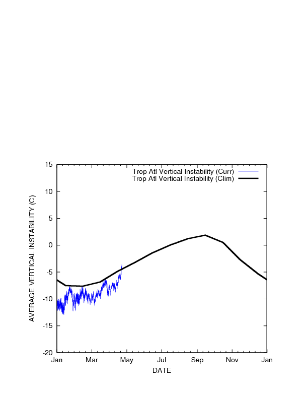
I do see that all the seasonal indicators favor development this year. The one factor that still bugs me is that instability remains below normal across the Atlantic Basin. I'd think that as we move toward summer and the Bermuda High weakens as forecast that the instability would creep upward to normal or above. If that happens, then we may be in for a wild ride this year. Caribbean islands, particularly the eastern Caribbean, would be at much higher risk of a major impact vs. 2012.

Image
0 likes   

User avatar
Hurricaneman
Category 5
Category 5
Posts: 7351
Age: 45
Joined: Tue Aug 31, 2004 3:24 pm
Location: central florida

Re: Expert forecasts for 2013 N Atlantic season (See 1rst post)

#79 Postby Hurricaneman » Sun Mar 31, 2013 11:22 am

With the 500 and 400mb pattern, expect the instability to go up really fast to above normal between May 1st to June 1st which is what many of the huge landfalling seasons have done and don't be suprised if 2013 has a similar track spray to 2005 in which if it formed in the MDR it would recurve into the open atlantic, but if a disturbance makes it to or past 65W it could spell trouble for
Florida and the GOM if the pattern holds

The posts in this forum are NOT official forecast and should not be used as such. They are just the opinion of the poster and may or may not be backed by sound meteorological data. They are NOT endorsed by any professional institution or storm2k.org. For official information, please refer to the NHC and NWS products
0 likes   

HURRICANELONNY
Category 5
Category 5
Posts: 1383
Joined: Wed May 07, 2003 6:48 am
Location: HOLLYWOOD.FL

Re: Expert forecasts for 2013 N Atlantic season (See 1rst post)

#80 Postby HURRICANELONNY » Sun Mar 31, 2013 11:34 am

I have to put my 2 cents in. As most of us know the pro's failed miserably in 2012. The factors change so fast it's hard to get a grip on what's happening in the tropics pertaining to Hurricane season. For sure and most models showed El Nino forming last year and it didn't. I don't know if El nino will form this year or if shear or SAL will have an influence. I guess any guess is good this early. :eek:
0 likes   
hurricanelonny


Return to “Talkin' Tropics”

Who is online

Users browsing this forum: HurakaYoshi and 45 guests