ENSO Updates (2007 thru 2023)
Moderator: S2k Moderators
Forum rules

The posts in this forum are NOT official forecasts and should not be used as such. They are just the opinion of the poster and may or may not be backed by sound meteorological data. They are NOT endorsed by any professional institution or STORM2K. For official information, please refer to products from the National Hurricane Center and National Weather Service.
-
dexterlabio
- Category 5

- Posts: 3507
- Joined: Sat Oct 24, 2009 11:50 pm
Re: ENSO: CPC June update=Neutral thru the Summer
LOL @ this El Nino scare. It came from the Euro and as we all know, it has encountered issues on inconsistent and not-so-accurate forecasts for the past year or two. But man, IF it were to happen, this is like 2006 all over again.
0 likes
Personal Forecast Disclaimer:
The posts in this forum are NOT official forecast and should not be used as such. They are just the opinion of the poster and may or may not be backed by sound meteorological data. They are NOT endorsed by any professional institution or storm2k.org. For official information, please refer to the NHC and NWS products.
The posts in this forum are NOT official forecast and should not be used as such. They are just the opinion of the poster and may or may not be backed by sound meteorological data. They are NOT endorsed by any professional institution or storm2k.org. For official information, please refer to the NHC and NWS products.


Re:
Kingarabian wrote:Is there anyway to check to see how consistent the ECMWF and the CFS models have been, in predicting past ENSO episodes?
CFSv2 is the main long term American model in use. Most data from it can be found here CFSv2, but I'm hard pressed to find any analysis data of previous enso stats.
Euro is a limited model for free and most forecasts used here is based on EUROSIP which is a combination of ECMWF, UK, France, and NCEP. You can review it's numbers compared to outcome through 2008 and beyond. Hope that helps!
EUROSIP
Edit: One must remember ENSO is not an easy thing for models to predict, or humans for that matter. This is simply because we do not have proper observations of underwater features and sites in the vast Pacific (and elsewhere) to input data for them, it's mostly reactionary to the data they have of the atmosphere. It's only fairly well predicted when you have a moderate or strong ENSO event that starts fast and hard that you see decent skill anything less is subject to high variability.
0 likes
The above post and any post by Ntxw is NOT an official forecast and should not be used as such. It is just the opinion of the poster and may or may not be backed by sound meteorological data. It is NOT endorsed by any professional institution including Storm2k. For official information, please refer to NWS products.
Help support Storm2K!
The May update of the PDO index was released today and for the first time since the El Nino of 2009-2010 we have a positive value indicating warm PDO, though small at +0.08 despite the ENSO cooling last month.
http://jisao.washington.edu/pdo/PDO.latest
So far June's SST's looks better than May for continued rising of the PDO with the warmest waters strengthening in the Northeast Pacific and cold waters emerging off the east coast of Australia, this should be taken into consideration for forecasts.
http://jisao.washington.edu/pdo/PDO.latest
So far June's SST's looks better than May for continued rising of the PDO with the warmest waters strengthening in the Northeast Pacific and cold waters emerging off the east coast of Australia, this should be taken into consideration for forecasts.
0 likes
The above post and any post by Ntxw is NOT an official forecast and should not be used as such. It is just the opinion of the poster and may or may not be backed by sound meteorological data. It is NOT endorsed by any professional institution including Storm2k. For official information, please refer to NWS products.
Help support Storm2K!
Help support Storm2K!
-
TropicalAnalystwx13

- Category 5
- Posts: 2109
- Age: 28
- Joined: Tue Jul 19, 2011 8:20 pm
- Location: Wilmington, NC
- Contact:
I'm not sure if we consider the signature in the Pacific a positive PDO signature. Warm anomalies are shifted more eastward for sure, but still not to the extent of a + signature. In addition, the waters from 160W to 140E are still above-average; during a positive PDO, these should be negative.
Looks like a negative PDO, just shifted farther east than usual...which is dangerous for landfalls.
Looks like a negative PDO, just shifted farther east than usual...which is dangerous for landfalls.
0 likes
Re:
TropicalAnalystwx13 wrote:I'm not sure if we consider the signature in the Pacific a positive PDO signature. Warm anomalies are shifted more eastward for sure, but still not to the extent of a + signature. In addition, the waters from 160W to 140E are still above-average; during a positive PDO, these should be negative.
Signature or not, it is a positive value regardless and ends the very long streak of several years being negative. It would likely need to rise 0.50+ or greater to start truly impacting as +PDO though. ENSO is the only thing keeping it from rising precipitously. Anomalous (warm northeast Pac) at first but has persisted for months now, something is keeping it there.
0 likes
The above post and any post by Ntxw is NOT an official forecast and should not be used as such. It is just the opinion of the poster and may or may not be backed by sound meteorological data. It is NOT endorsed by any professional institution including Storm2k. For official information, please refer to NWS products.
Help support Storm2K!
Help support Storm2K!
-
cycloneye

- Admin

- Posts: 149468
- Age: 69
- Joined: Thu Oct 10, 2002 10:54 am
- Location: San Juan, Puerto Rico
Re: Re:
Ntxw wrote:TropicalAnalystwx13 wrote:I'm not sure if we consider the signature in the Pacific a positive PDO signature. Warm anomalies are shifted more eastward for sure, but still not to the extent of a + signature. In addition, the waters from 160W to 140E are still above-average; during a positive PDO, these should be negative.
Signature or not, it is a positive value regardless and ends the very long streak of several years being negative. It would likely need to rise 0.50+ or greater to start truly impacting as +PDO though. ENSO is the only thing keeping it from rising precipitously. Anomalous (warm northeast Pac) at first but has persisted for months now, something is keeping it there.
A question trying to understand better about the PDO. What is the effect of a positive PDO on the North Atlantic Hurricane season?
0 likes
Visit the Caribbean-Central America Weather Thread where you can find at first post web cams,radars
and observations from Caribbean basin members Click Here
and observations from Caribbean basin members Click Here
Re: Re:
cycloneye wrote:A question trying to understand better about the PDO. What is the effect of a positive PDO on the North Atlantic Hurricane season?
Tropical season is not my expertise and I'm sure there are others here who can explain it much better. I do know that PDO effects greatly the weather pattern across NA. A +PDO would likely increase chances of landfalls in the SE US as troughs tend to dig into the eastern CONUS due to the high pressure (the anomalous one that has persisted) off the west coast. A ridge will center itself between the SW and southern plains forcing a trough/weakness near the gulf or east coast. It's not really a numbers game with the PDO aside from + or - enhancing ENSO which indirectly effects.
0 likes
The above post and any post by Ntxw is NOT an official forecast and should not be used as such. It is just the opinion of the poster and may or may not be backed by sound meteorological data. It is NOT endorsed by any professional institution including Storm2k. For official information, please refer to NWS products.
Help support Storm2K!
Help support Storm2K!
-
hurricanetrack

- HurricaneTrack.com
- Posts: 1781
- Joined: Tue Dec 02, 2003 10:46 pm
- Location: Wilmington, NC
- Contact:

Re: ENSO: CPC June update=Neutral thru the Summer
0 likes
-
Kingarabian

- S2K Supporter

- Posts: 16364
- Joined: Sat Aug 08, 2009 3:06 am
- Location: Honolulu, Hawaii

-
cycloneye
- Admin
- Posts: 149468
- Age: 69
- Joined: Thu Oct 10, 2002 10:54 am
- Location: San Juan, Puerto Rico
Re: ENSO: CPC June update=Neutral thru the Summer
Latest ESPI data:-1.80
Another factor that screams no El Nino.The more negative this is,the less likely El Nino will come in the next few months.
http://trmm.gsfc.nasa.gov//trmm_rain/Ev ... y_day.html
Another factor that screams no El Nino.The more negative this is,the less likely El Nino will come in the next few months.
http://trmm.gsfc.nasa.gov//trmm_rain/Ev ... y_day.html
0 likes
Visit the Caribbean-Central America Weather Thread where you can find at first post web cams,radars
and observations from Caribbean basin members Click Here
and observations from Caribbean basin members Click Here
-
hurricanetrack
- HurricaneTrack.com
- Posts: 1781
- Joined: Tue Dec 02, 2003 10:46 pm
- Location: Wilmington, NC
- Contact:
-
beoumont

- Category 1

- Posts: 473
- Joined: Sun Jul 10, 2011 4:13 pm
- Location: East Central Florida
- Contact:
Re: ENSO Updates: Latest ESPI: -1.82

0 likes
List of 79 tropical cyclones intercepted by Richard Horodner:
http://www.canebeard.com/page/page/572246.htm
http://www.canebeard.com/page/page/572246.htm
Re: ENSO Updates: Latest ESPI: -1.82
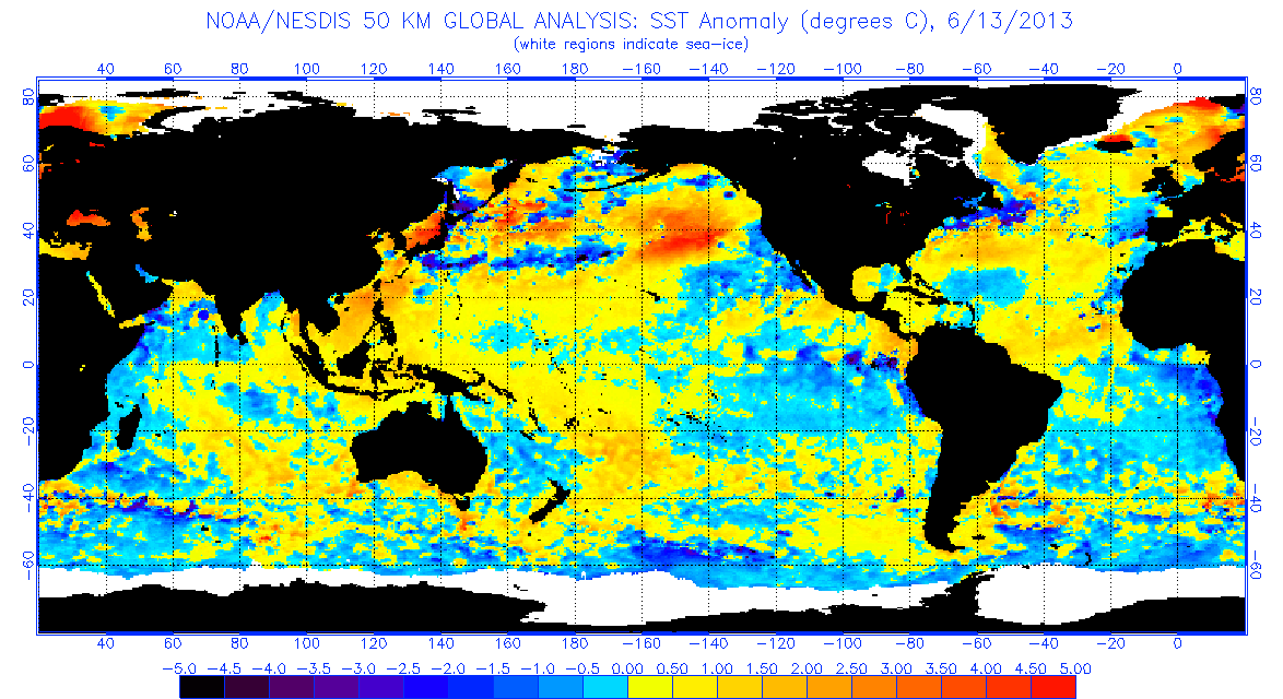
It's interesting how wound up people can get when one or two model runs that go against the trend, no matter what that trend is. If we were looking at a full-scale warm episode evolving (which we're not), any model that made a slight change to cool would be similarly pounced upon.
We're in the second 10 day period in June now...and if a warm episode were indeed evolving, Occam's Razor says there would be evidence of that happening someplace in the ocean, right?
Which of these two mid-June SST anomaly maps would have you more worried about El Nino? A or B?
A: http://www.ospo.noaa.gov/data/sst/anoma ... 3.2013.gif
B: http://www.ospo.noaa.gov/data/sst/anoma ... 1.2005.gif
MW
We're in the second 10 day period in June now...and if a warm episode were indeed evolving, Occam's Razor says there would be evidence of that happening someplace in the ocean, right?
Which of these two mid-June SST anomaly maps would have you more worried about El Nino? A or B?
A: http://www.ospo.noaa.gov/data/sst/anoma ... 3.2013.gif
B: http://www.ospo.noaa.gov/data/sst/anoma ... 1.2005.gif
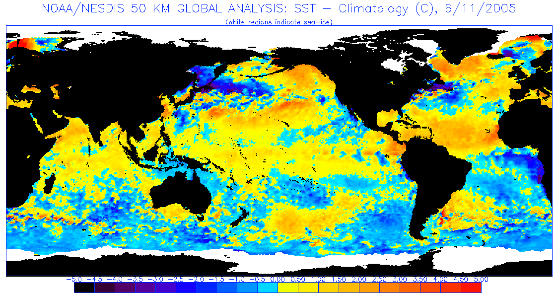
MW
0 likes
Updating on the twitter now: http://www.twitter.com/@watkinstrack
Re: ENSO Updates: Latest ESPI: -1.82
beoumont wrote:...
Isn't this image/probability outlook based on Nino 3.4 only? How will the tropical atmosphere respond to a slightly warm 3.4 with a cold eastern Pacific in ASO?
MW
0 likes
Updating on the twitter now: http://www.twitter.com/@watkinstrack
-
beoumont
- Category 1
- Posts: 473
- Joined: Sun Jul 10, 2011 4:13 pm
- Location: East Central Florida
- Contact:
Re: ENSO Updates: Latest ESPI: -1.82
MWatkins wrote:beoumont wrote:...
Isn't this image/probability outlook based on Nino 3.4 only? How will the tropical atmosphere respond to a slightly warm 3.4 with a cold eastern Pacific in ASO?
MW
I can't answer the specific question. But, the graphic indicates there is only a 12% chance of an el nino episode in August, Sept., Oct. ---- and a 57% chance of neutral conditions, and 31% chance of la nina in zones 3-4. Those numbers say the odds of a slightly warm 3.4 in ASO are quite slim. Right now the 3.4 zone is normal to slightly cooler than normal; and it is June already.

Last edited by beoumont on Thu Jun 13, 2013 12:21 pm, edited 2 times in total.
0 likes
List of 79 tropical cyclones intercepted by Richard Horodner:
http://www.canebeard.com/page/page/572246.htm
http://www.canebeard.com/page/page/572246.htm
Re: ENSO Updates: Latest ESPI: -1.82
beoumont wrote:MWatkins wrote:beoumont wrote:...
Isn't this image/probability outlook based on Nino 3.4 only? How will the tropical atmosphere respond to a slightly warm 3.4 with a cold eastern Pacific in ASO?
MW
I can't answer the specific question. But, the graphic indicates there is only a 12% chance of an el nino episode in August, Sept., Oct. ---- and a 57% chance of neutral conditions, and 31% chance of la nina in zones 3-4. Those numbers say the odds of a slightly warm 3.4 in ASO are quite slim. Right now the 3.4 zone is slightly cooler than normal; and it is mid June already.
Exactly. That's an 88% chance of a neutral or cold event in the next few months. Those are "all in before the flop" poker odds!
MW
0 likes
Updating on the twitter now: http://www.twitter.com/@watkinstrack
Ok folks lets lay this El Nino stuff to rest. There is no El Nino or La Nina, we are in neutral and will stay there likely through peak tropical season. Wxman57 only mentioned that the Euro looked warmer than before he didn't say an El Nino was coming. The only changes is that the PDO rose to positive and sub-surface waters transitioned against the cold pool underneath, that is all. CFSv2 has been going warm but it too is very borderline so even it has no confidence and waffles.
I know the term "El Nino" is devil's words in the tropical threads so to prevent panic lets avoid using it unless we are sure it's coming.
I know the term "El Nino" is devil's words in the tropical threads so to prevent panic lets avoid using it unless we are sure it's coming.
0 likes
The above post and any post by Ntxw is NOT an official forecast and should not be used as such. It is just the opinion of the poster and may or may not be backed by sound meteorological data. It is NOT endorsed by any professional institution including Storm2k. For official information, please refer to NWS products.
Help support Storm2K!
Help support Storm2K!
-
MGC

- S2K Supporter
- Posts: 5940
- Joined: Sun Mar 23, 2003 9:05 pm
- Location: Pass Christian MS, or what is left.
Re: ENSO Updates: Latest ESPI: -1.80
Betting the farm on no El Nino. Neutral to cold it appears.....MGC
0 likes
Who is online
Users browsing this forum: Google [Bot] and 180 guests