ATL: DORIAN - Post-Tropical - Discussion
Moderator: S2k Moderators

Re: ATL: INVEST 91L - Dorian Remnants - Discussion
I think so but I read that the next recon schedule is 2pm tomorrow
0 likes
-
SapphireSea
- Category 1

- Posts: 430
- Joined: Wed Aug 24, 2005 12:13 pm
- Location: Miami, FL
Re: ATL: INVEST 91L - Dorian Remnants - Discussion
Been reviewing the new images from the CIMSS and it does not look like the shear zone is moving as fast as Dorian. Dorian looks like it will be mauled by the TUTT shear some time tomorrow unless the call for it to weaken come true. My optimism with the storm is waning like it's convection.
0 likes
Forecast Disclaimer:
Don't be stupid. Make your own informed decisions.
Don't be stupid. Make your own informed decisions.


-
cycloneye

- Admin

- Posts: 149479
- Age: 69
- Joined: Thu Oct 10, 2002 10:54 am
- Location: San Juan, Puerto Rico
Re: ATL: INVEST 91L - Dorian Remnants - Discussion
blp wrote:Was the 10:30pm recon cancelled?
I think Chris_in_Tampa makes valid points about recon not going at this time. See what he posted here.
0 likes
Visit the Caribbean-Central America Weather Thread where you can find at first post web cams,radars
and observations from Caribbean basin members Click Here
and observations from Caribbean basin members Click Here

Re: ATL: INVEST 91L - Dorian Remnants - Discussion
SapphireSea wrote:Been reviewing the new images from the CIMSS and it does not look like the shear zone is moving as fast as Dorian. Dorian looks like it will be mauled by the TUTT shear some time tomorrow unless the call for it to weaken come true. My optimism with the storm is waning like it's convection.
Yea, I am not sure the TUTT will pull out quick enough either. It is going to be close.
0 likes
The following post is NOT an official forecast and should not be used as such. It is just the opinion of the poster and may or may not be backed by sound meteorological data. It is NOT endorsed by any professional institution including storm2k.org For Official Information please refer to the NHC and NWS products.
-
Hurricaneman

- Category 5

- Posts: 7404
- Age: 45
- Joined: Tue Aug 31, 2004 3:24 pm
- Location: central florida
Re:
HURAKAN wrote:
recent ASCAT pass ... sharp wave
The vortex we have been following is nowhere near where the low level wave is so there indeed has not been a relocation under the convection so this still has a long way to go in terms of redevelopment
The posts in this forum are NOT official forecast and should not be used as such. They are just the opinion of the poster and may or may not be backed by sound meteorological data. They are NOT endorsed by any professional institution or storm2k.org. For official information, please refer to the NHC and NWS products
0 likes
-
ozonepete
- Professional-Met

- Posts: 4743
- Joined: Mon Sep 07, 2009 3:23 pm
- Location: From Ozone Park, NYC / Now in Brooklyn, NY
Re: ATL: INVEST 91L - Dorian Remnants - Discussion
There was just a flurry of posts saying that convection is weak and not increasing. What am I missing?
7:45PM:

11:45PM:
7:45PM:

11:45PM:

0 likes
-
Brent
- S2K Supporter

- Posts: 38753
- Age: 37
- Joined: Sun May 16, 2004 10:30 pm
- Location: Tulsa Oklahoma
- Contact:
Re: ATL: INVEST 91L - Dorian Remnants - Discussion
blp wrote:Was the 10:30pm recon cancelled?
Recon doesn't do nighttime invests...
0 likes
#neversummer
-
beoumont

- Category 1
- Posts: 473
- Joined: Sun Jul 10, 2011 4:13 pm
- Location: East Central Florida
- Contact:
Re: ATL: INVEST 91L - Dorian Remnants - Discussion
Ditto.

Last edited by beoumont on Sun Jul 28, 2013 11:11 pm, edited 2 times in total.
0 likes
List of 79 tropical cyclones intercepted by Richard Horodner:
http://www.canebeard.com/page/page/572246.htm
http://www.canebeard.com/page/page/572246.htm
-
SFLcane

- S2K Supporter
- Posts: 10281
- Age: 48
- Joined: Sat Jun 05, 2010 1:44 pm
- Location: Lake Worth Florida
Re: ATL: INVEST 91L - Dorian Remnants - Discussion
Convection might still be increasing ozonepete but did you see the ASCAT that was posted? Nothing here to be real concerned about yet. Sharp wave
Last edited by SFLcane on Sun Jul 28, 2013 11:11 pm, edited 1 time in total.
0 likes
-
SFLcane
- S2K Supporter
- Posts: 10281
- Age: 48
- Joined: Sat Jun 05, 2010 1:44 pm
- Location: Lake Worth Florida
Re: ATL: INVEST 91L - Dorian Remnants - Discussion
beoumont wrote:Ditto. Circle the wagons:
Richard! Talk to me.. Mean looking wave :0)
0 likes
-
thundercam96

- Tropical Storm

- Posts: 129
- Joined: Thu Aug 18, 2011 3:01 pm
- Location: Boston, MA
Re:
TheStormExpert wrote:Here's a look at the Mid. Level Water Vapor Imagery:

Not to be off-topic,but are any models developing that wave in Western Africa when it exits into the Atlantic?
Last edited by thundercam96 on Sun Jul 28, 2013 11:22 pm, edited 1 time in total.
0 likes
Fay '08 / Mathew 16'
Personal Forecast Disclaimer: I am not a certified meteorologist, therefore, what is posted on this forum under my header should not be treated as an official forecast. Please refer to the NWS/NHC products for forecast information.
Personal Forecast Disclaimer: I am not a certified meteorologist, therefore, what is posted on this forum under my header should not be treated as an official forecast. Please refer to the NWS/NHC products for forecast information.
-
CYCLONE MIKE
- Category 5
- Posts: 2183
- Joined: Tue Aug 31, 2004 6:04 pm
- Location: Gonzales, LA
Re: ATL: INVEST 91L - Dorian Remnants - Discussion
Evil Jeremy wrote:Blown Away wrote:The 00z GFS doesn't even show a low through 45 hours...IMO the lack of development w/ these models can't be ignored...If the environment truly favored some development I think we would see some indication in the model runs...Nothing run after run...
Most, if not all of the models seem to be off so far this season. Even the ECMWF has barely detected any activity. And even if the models don't say anything is forming... we can see it on satellite. Models aren't always right. And they haven't been very attentive so far this year.
I am not a model apologist by any means, in fact far from it, but must give credit where credit is due.They were insistent on Chantal and Dorian falling apart And look what happened. If they aren't showing any development in the near term it must be for a reason.
0 likes
-
Evil Jeremy

- S2K Supporter
- Posts: 5463
- Age: 32
- Joined: Mon Apr 10, 2006 2:10 pm
- Location: Los Angeles, CA
Re: ATL: INVEST 91L - Dorian Remnants - Discussion
CYCLONE MIKE wrote:Evil Jeremy wrote:Blown Away wrote:The 00z GFS doesn't even show a low through 45 hours...IMO the lack of development w/ these models can't be ignored...If the environment truly favored some development I think we would see some indication in the model runs...Nothing run after run...
Most, if not all of the models seem to be off so far this season. Even the ECMWF has barely detected any activity. And even if the models don't say anything is forming... we can see it on satellite. Models aren't always right. And they haven't been very attentive so far this year.
I am not a model apologist by any means, in fact far from it, but must give credit where credit is due.They were insistent on Chantal and Dorian falling apart And look what happened. If they aren't showing any development in the near term it must be for a reason.
The models barely showed Chantal and Dorian forming in the first place.
0 likes
Frances 04 / Jeanne 04 / Katrina 05 / Wilma 05 / Fay 08 / Debby 12 / Andrea 13 / Colin 16 / Hermine 16 / Matthew 16 / Irma 17
Re: ATL: INVEST 91L - Dorian Remnants - Discussion
I agree with ozonepete the convection has really increased in that 4 hour span.
0 likes
-
Cainer

- Tropical Storm
- Posts: 188
- Age: 34
- Joined: Mon May 05, 2008 3:26 pm
- Location: Yarmouth, Nova Scotia

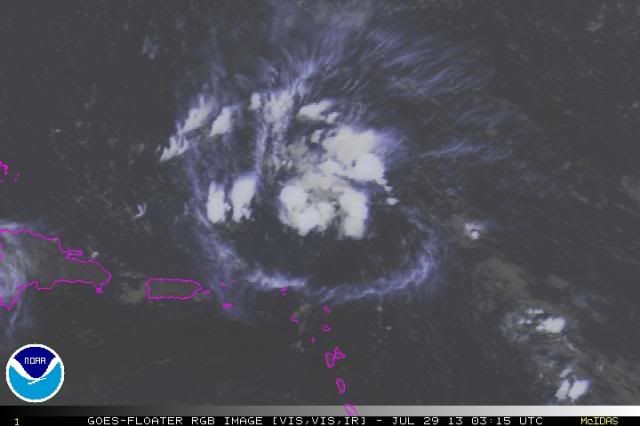
Just a quick little diagram of what I'm seeing in the last couple RGB frames. First off, you can see the upper-level outflow beginning to bunch up to the west of the system, indicating that it is approaching the axis of the TUTT. Secondly, the storms that are redeveloping to the west of the storm are being sheared, unlike the storms near the center of the MLC which remain in a light shear environment. These two factors indicates that the environment ex-Dorian will be heading into will be more hostile than it is right now, and I feel that any development will be pretty slow to occur.
The posts in this forum are NOT official forecast and should not be used as such. They are just the opinion of the poster and may or may not be backed by sound meteorological data. They are NOT endorsed by any professional institution or storm2k.org. For official information, please refer to the NHC and NWS products
0 likes
-
Aric Dunn
- Category 5
- Posts: 21238
- Age: 43
- Joined: Sun Sep 19, 2004 9:58 pm
- Location: Ready for the Chase.
- Contact:
looking good.... it will survive as long as the tutt keeps retrograting
0 likes
Note: If I make a post that is brief. Please refer back to previous posts for the analysis or reasoning. I do not re-write/qoute what my initial post said each time.
If there is nothing before... then just ask
Space & Atmospheric Physicist, Embry-Riddle Aeronautical University,
I believe the sky is falling...
If there is nothing before... then just ask
Space & Atmospheric Physicist, Embry-Riddle Aeronautical University,
I believe the sky is falling...
-
ozonepete
- Professional-Met
- Posts: 4743
- Joined: Mon Sep 07, 2009 3:23 pm
- Location: From Ozone Park, NYC / Now in Brooklyn, NY
Re: ATL: INVEST 91L - Dorian Remnants - Discussion
SFLcane wrote:Convection might still be increasing ozonepete but did you see the ASCAT that was posted? Nothing here to be real concerned about yet. Sharp wave
Hey there SFL.
And my two cents is that the models have done really poorly with this overall so far but they often do with a developing or redeveloping system when conditions are marginal.
0 likes

Re: ATL: INVEST 91L - Models
the 0Z GFS does not have anything at all.....just a wave....you cant even follow the 850mb vort because there is not one....
guess all these models showing the same solution are wrong....
guess all these models showing the same solution are wrong....
0 likes
-
Chris_in_Tampa
- Category 5
- Posts: 5101
- Age: 42
- Joined: Thu Jun 21, 2007 11:06 pm
- Location: Tampa, Florida, USA
- Contact:
Re: ATL: INVEST 91L - Dorian Remnants - Discussion
Another view of that satellite pass, with two images I merged together:

From: http://manati.star.nesdis.noaa.gov/data ... TBData.php
Image 1: http://manati.star.nesdis.noaa.gov/asca ... MBas88.png
Image 2: http://manati.star.nesdis.noaa.gov/asca ... MBas87.png
From: http://manati.star.nesdis.noaa.gov/data ... TBData.php
Image 1: http://manati.star.nesdis.noaa.gov/asca ... MBas88.png
Image 2: http://manati.star.nesdis.noaa.gov/asca ... MBas87.png
0 likes
Who is online
Users browsing this forum: No registered users and 35 guests