

The 12Z CMC dropped the Gulf system and shows nothing else through 240 hours.
The 12Z GFS dropped the W Car / BOC system and shows nothing else through 384 hours.
The 12Z NAVGEM shows nothing through 180 hours.
Global model runs discussion
Moderator: S2k Moderators
-
floridasun78
- Category 5

- Posts: 3755
- Joined: Sun May 17, 2009 10:16 pm
- Location: miami fl
-
cycloneye

- Admin

- Posts: 149473
- Age: 69
- Joined: Thu Oct 10, 2002 10:54 am
- Location: San Juan, Puerto Rico
Re: Global Model Runs Discussion
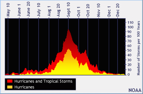
It's weird that the reliable models don't have anything so far in August as the season is starting to climb the mountain to the September 10 peak day.
0 likes
Visit the Caribbean-Central America Weather Thread where you can find at first post web cams,radars
and observations from Caribbean basin members Click Here
and observations from Caribbean basin members Click Here


The MJO for the most part is incoherent and virtually all of the models keep it that way inside the circle. GFS does show hints of it in phase 1 but I'm not buying it. For the most part the MJO is not favorable or unfavorable for development, we'll have to look at other factors for guidance.
0 likes
The above post and any post by Ntxw is NOT an official forecast and should not be used as such. It is just the opinion of the poster and may or may not be backed by sound meteorological data. It is NOT endorsed by any professional institution including Storm2k. For official information, please refer to NWS products.
Help support Storm2K!


Re: Global Model Runs Discussion
12Z is just one run...wait for the 18Z....they have already started sniffing out long range activity. It wont be long before it sticks and moves into the med range.
0 likes

Re: Global Model Runs Discussion
ROCK wrote:LaBreeze wrote:ROCK wrote::uarrow: granted its la la land but it shows that in a week or two the lid is coming off...IMO....
Please elaborate - what are some of the scenarios that you are seeing with this? Fill us in -
A. models long range sniffing out development
B. models suggesting lowering pressures
C. the MJO is making its way around in a week or 2
D. the sst's are toasty
E. CSU updated their forecast to 18/8/3...we are not even close yet
F. the current SAL surge will be gone
G. Climo suggest an uptick in August
H. model suggest strong ridging in the long range which would result in US landfalls
I. gut feeling
J. I had a vision
K. I was eating my mash potatoes and for some reason I started making a cat 5 hurricane out of them.
thats all I can think of attm....
I love it Rock - especially letter "K". Sometimes I feel like "I" and "J" as well. Thanks for answering and I hope you enjoyed your Cat 5 potatoes.
0 likes
-
Hurricane Alexis

- Category 2

- Posts: 683
- Age: 29
- Joined: Thu Jun 14, 2012 7:59 pm
- Location: Miami,Florida
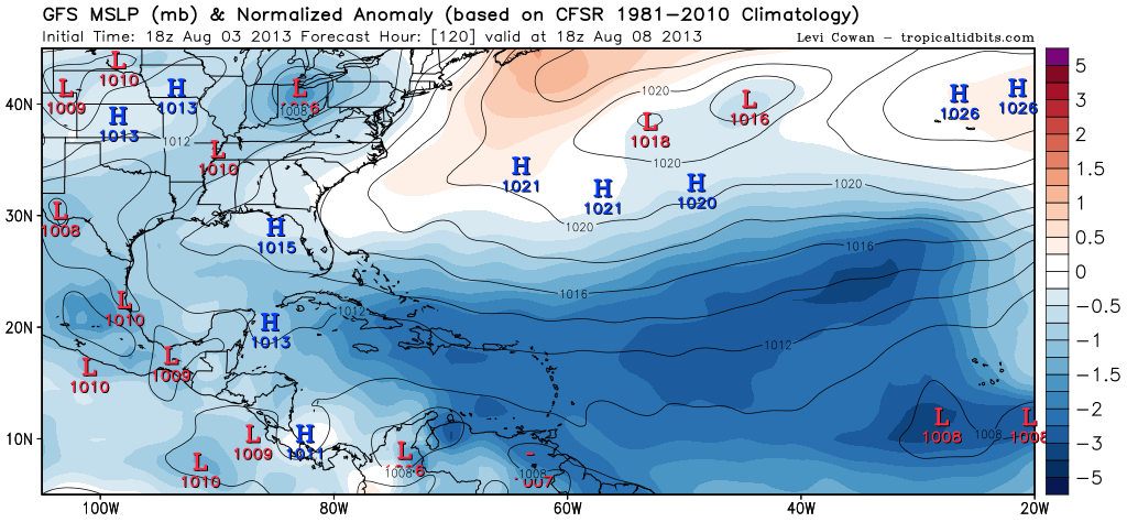
12z CMC ensembles begin to show lower pressures in the eastern Atlantic in about 5 days and on. Time range has gone down so it's been consistent with this idea the last few days.

Uploaded with ImageShack.us

Uploaded with ImageShack.us
0 likes
Personal Forecast Disclaimer:
The posts in this forum are NOT official forecast and should not be used as such. They are just the opinion of the poster and may or may not be backed by sound meteorological data. They are NOT endorsed by any professional institution or storm2k.org. For official information, please refer to the NHC and NWS products.
The posts in this forum are NOT official forecast and should not be used as such. They are just the opinion of the poster and may or may not be backed by sound meteorological data. They are NOT endorsed by any professional institution or storm2k.org. For official information, please refer to the NHC and NWS products.
-
cycloneye
- Admin
- Posts: 149473
- Age: 69
- Joined: Thu Oct 10, 2002 10:54 am
- Location: San Juan, Puerto Rico
Re: Global Model Runs Discussion
0 likes
Visit the Caribbean-Central America Weather Thread where you can find at first post web cams,radars
and observations from Caribbean basin members Click Here
and observations from Caribbean basin members Click Here
-
TheStormExpert
Re: Global Model Runs Discussion
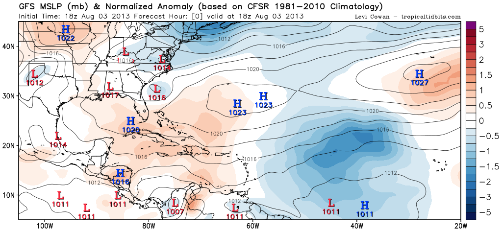
cycloneye wrote::uarrow: Look where is the Azores High located,well NE which causes less trade winds in the lower latitudes of MDR.
Which means whatever storms develop off of Africa will recurve right?
0 likes

-
TheStormExpert
Re:
Hurricane Alexis wrote:12z CMC ensembles begin to show lower pressures in the eastern Atlantic in about 5 days and on. Time range has gone down so it's been consistent with this idea the last few days.
Uploaded with ImageShack.us
Those lower pressures in the Eastern Atlantic just west of the Cape Verde islands have been shown on a few different models over the past 5-7 days.
0 likes
Re: Global Model Runs Discussion
TheStormExpert wrote:cycloneye wrote::uarrow: Look where is the Azores High located,well NE which causes less trade winds in the lower latitudes of MDR.
Which means whatever storms develop off of Africa will recurve right?
Look @ 1016 pressure line all the way to FL long tracker AZ high upper R/S all the blue High pressure numbers while the low pressure(red)are further S.Atleast that is my take
0 likes
-
CYCLONE MIKE
- Category 5
- Posts: 2183
- Joined: Tue Aug 31, 2004 6:04 pm
- Location: Gonzales, LA
Re: Global Model Runs Discussion
Since it looks like there wont be anything going on in the next few weeks at the very least, let's talk about some long range football. LSU #13 will be making a run this year. Am feeling a lot more confident about that than the lid coming off in 2-3 more weeks.  sorry just had to get that out. Pumped up its almost time.
0 likes
-
cycloneye
- Admin
- Posts: 149473
- Age: 69
- Joined: Thu Oct 10, 2002 10:54 am
- Location: San Juan, Puerto Rico
Re: Global Model Runs Discussion
CYCLONE MIKE wrote:Since it looks like there wont be anything going on in the next few weeks at the very least, let's talk about some long range football. LSU #13 will be making a run this year. Am feeling a lot more confident about that than the lid coming off in 2-3 more weeks.
We have a sports forum where you can talk all about sports.
viewforum.php?f=17
0 likes
Visit the Caribbean-Central America Weather Thread where you can find at first post web cams,radars
and observations from Caribbean basin members Click Here
and observations from Caribbean basin members Click Here
-
ninel conde
Re: Global Model Runs Discussion
CYCLONE MIKE wrote:Since it looks like there wont be anything going on in the next few weeks at the very least, let's talk about some long range football. LSU #13 will be making a run this year. Am feeling a lot more confident about that than the lid coming off in 2-3 more weeks.
models are giving hints for late in the month.
0 likes
-
CYCLONE MIKE
- Category 5
- Posts: 2183
- Joined: Tue Aug 31, 2004 6:04 pm
- Location: Gonzales, LA
Re: Global Model Runs Discussion
cycloneye wrote:CYCLONE MIKE wrote:Since it looks like there wont be anything going on in the next few weeks at the very least, let's talk about some long range football. LSU #13 will be making a run this year. Am feeling a lot more confident about that than the lid coming off in 2-3 more weeks.
We have a sports forum where you can talk all about sports.
viewforum.php?f=17
Thanks cycloneye did not know this, appreciate it.
Ninel, might be showing hints but have done it many times before and where did that leave us. Just going in wait and see mode til things actually do come alive.
0 likes
-
Hurricaneman

- Category 5
- Posts: 7404
- Age: 45
- Joined: Tue Aug 31, 2004 3:24 pm
- Location: central florida
The 0zGFS is now picking up on something coming off of africa at day 7 as a 1002 mb low at about 18N and moves it west to north of due west until about 13 days when it get picked up by the trough but as we all know the steering currents could be alot different in more than 5 days than what is modeled
as a side note another system starts a formation at 300hrs and at hr 384 is at 13N 50W as a 1008 mb low so the GFS shows the lid coming off around mid August and possibly being relentless at least starting next week which would follow very well with climatology
P.S. it joins the Euro with a low at 18N
The posts in this forum are NOT official forecast and should not be used as such. They are just the opinion of the poster and may or may not be backed by sound meteorological data. They are NOT endorsed by any professional institution or storm2k.org. For official information, please refer to the NHC and NWS products
0 likes
Who is online
Users browsing this forum: No registered users and 68 guests