ATL: GABRIELLE - Remnants - Discussion
Moderator: S2k Moderators
-
HurricaneDREW92
- Category 1

- Posts: 320
- Age: 27
- Joined: Sun Jul 28, 2013 11:56 am
- Location: Boston, MA
Re: ATL: INVEST 97L - Discussion
Id give it 30/50% at the 8pm TWO.
0 likes
This post is NOT AN OFFICIAL FORECAST and should not be used as such. It is just the opinion of the poster and may or may not be backed by sound meteorological data. It is NOT endorsed by any professional institution including storm2k.org. For Official Information please refer to the NHC and NWS products.
-THE ABOVE IS THE OPINION OF DREW ONLY
-THE ABOVE IS THE OPINION OF DREW ONLY
-
USTropics
- Professional-Met

- Posts: 2738
- Joined: Sun Aug 12, 2007 3:45 am
- Location: Florida State University
Re: ATL: INVEST 97L - Discussion
Unlike the past few disturbances we've been tracking where there's been a vigorous mid level circulation, but nothing able to really get going at the surface, 97L is the opposite. We have good low level vorticity, but mid-level vorticity is lacking to say the least. This is mostly likely the cause of shear associated with the ULL currently. There is A LOT of air being piled up in the western Caribbean, so if 97L makes it's way to that area with the current structure, things will get interesting.
low-level vorticity:

mid-level vorticity:

low-level vorticity:
mid-level vorticity:
0 likes
-
wxman57

- Moderator-Pro Met

- Posts: 23175
- Age: 68
- Joined: Sat Jun 21, 2003 8:06 pm
- Location: Houston, TX (southwest)
Re: ATL: INVEST 97L - Discussion
Quite a strong circulation evident on the MIMIC-TPW loop. Climatologically, such a strong wave might have a 30-40% chance of development in the Caribbean in 3-4 days. But I think development chances are higher than that. Probably after it passes west of the DR and is in the vicinity of PR. Could be a storm threatening the Gulf in 5 days.
0 likes
-
ConvergenceZone
.gif)
- Category 5

- Posts: 5241
- Joined: Fri Jul 29, 2005 1:40 am
- Location: Northern California
Re: ATL: INVEST 97L - Discussion
wxman57 wrote:Quite a strong circulation evident on the MIMIC-TPW loop. Climatologically, such a strong wave might have a 30-40% chance of development in the Caribbean in 3-4 days. But I think development chances are higher than that. Probably after it passes west of the DR and is in the vicinity of PR. Could be a storm threatening the Gulf in 5 days.
Good to get your input on this Wxman. Perhaps this is finally the signal that the tropics are coming alive, but until it happens, I'm still in a believe it when I see it mode
0 likes
This has the look of something that wants to give it a go. And it's the time of the year that everything needs to be watched. How anyone, blue tag or otherwise, can confidently declare something isn't going to develop is frankly a bit baffling to me. Stuff changes quick, especially at this time of the year. This is why model runs devoid of canes over a two week timeframe at this time of year are laughable IMO. maybe but maybe not. would they have picked up on the '35 labor day cane or the myriad of other rapid developers in the history books around this time? I doubt it. No matter what happens, at least we have SOMETHING to look at that is slightly interesting. I'll take it.
0 likes
-
HurricaneDREW92
- Category 1
- Posts: 320
- Age: 27
- Joined: Sun Jul 28, 2013 11:56 am
- Location: Boston, MA
Re: ATL: INVEST 97L - Discussion
wxman57 wrote:Quite a strong circulation evident on the MIMIC-TPW loop. Climatologically, such a strong wave might have a 30-40% chance of development in the Caribbean in 3-4 days. But I think development chances are higher than that. Probably after it passes west of the DR and is in the vicinity of PR. Could be a storm threatening the Gulf in 5 days.
Obviously its very early, any indications this makes landfall in the Carolinas, wxman57?
0 likes
This post is NOT AN OFFICIAL FORECAST and should not be used as such. It is just the opinion of the poster and may or may not be backed by sound meteorological data. It is NOT endorsed by any professional institution including storm2k.org. For Official Information please refer to the NHC and NWS products.
-THE ABOVE IS THE OPINION OF DREW ONLY
-THE ABOVE IS THE OPINION OF DREW ONLY


Re: ATL: INVEST 97L - Discussion
wxman57 wrote:Quite a strong circulation evident on the MIMIC-TPW loop. Climatologically, such a strong wave might have a 30-40% chance of development in the Caribbean in 3-4 days. But I think development chances are higher than that. Probably after it passes west of the DR and is in the vicinity of PR. Could be a storm threatening the Gulf in 5 days.
wxman57 as a GOM resident,your last sentence peaked my interest.Would you care to elaborate on why you think this system will enter the GOM.
0 likes
-
Hybridstorm_November2001

- S2K Supporter

- Posts: 2817
- Joined: Sat Aug 21, 2004 2:50 pm
- Location: SW New Brunswick, Canada
- Contact:
Re: ATL: INVEST 97L - Discussion
Metro-France Radar from the Lesser Antilles, if anyone wants to watch this thing as it gets into coverage range:
http://www.meteo.fr/temps/domtom/antilles/pack-public/animation/animMOSAIC2.html
http://www.meteo.fr/temps/domtom/antilles/pack-public/animation/animMOSAIC2.html
0 likes
-
Gustywind

- Category 5
- Posts: 12334
- Joined: Mon Sep 03, 2007 7:29 am
- Location: Baie-Mahault, GUADELOUPE
Re: ATL: INVEST 97L - Discussion
Hybridstorm_November2001 wrote:Metro-France Radar from the Lesser Antilles, if anyone wants to watch this thing as it gets into coverage range:
http://www.meteo.fr/temps/domtom/antilles/pack-public/animation/animMOSAIC2.html
By the way, Guadeloupe is since 5PM under an yellow alert for a risk of strong showers and tstorms. Given our Pro Mets and the latest weather forecast: " The evening and the night of Saturday to Sunday should see numerous stormy passages of showers and tstorms who will affect Guadeloupe. They shoud bring rainfall locally strong. This deterioration is the start of an important rainy and stormy episode expected to stall several days".
Yellow alert for Guadeloupe : http://www.meteo.gp/donnees/bulletin/vi ... ilance.php
0 likes

Re: ATL: INVEST 97L - Discussion
wxman57 wrote:Quite a strong circulation evident on the MIMIC-TPW loop. Climatologically, such a strong wave might have a 30-40% chance of development in the Caribbean in 3-4 days. But I think development chances are higher than that. Probably after it passes west of the DR and is in the vicinity of PR. Could be a storm threatening the Gulf in 5 days.
I think 97L could be our first hurricane of the season, especially when it goes over Caribbean.
Personal Forecast Disclaimer:
The posts in this forum are NOT official forecast and should not be used as such. They are just the opinion of the poster and may or may not be backed by sound meteorological data. They are NOT endorsed by any professional institution or storm2k.org. For official information, please refer to the NHC and NWS products.
0 likes
-
USTropics
- Professional-Met
- Posts: 2738
- Joined: Sun Aug 12, 2007 3:45 am
- Location: Florida State University
Re: ATL: INVEST 97L - Discussion
perk wrote:wxman57 wrote:Quite a strong circulation evident on the MIMIC-TPW loop. Climatologically, such a strong wave might have a 30-40% chance of development in the Caribbean in 3-4 days. But I think development chances are higher than that. Probably after it passes west of the DR and is in the vicinity of PR. Could be a storm threatening the Gulf in 5 days.
wxman57 as a GOM resident,your last sentence peaked my interest.Would you care to elaborate on why you think this system will enter the GOM.
The general wave axis will continue west. For instance, the 12z ECWMF, which doesn't show development, continues the wave axis through the Yucatan peninsula and into the BOC. Some energy behind 97L appears to be the vorticity that lifts north of PR. Even the most aggressive model with 97L, the CMC, shows this moving pretty far south in the Caribbean before lifting it north (and also develops some energy behind this system).
CMC 12z 850mb vort out to 66 hrs:

0 likes
-
CYCLONE MIKE
- Category 5
- Posts: 2183
- Joined: Tue Aug 31, 2004 6:04 pm
- Location: Gonzales, LA
Re: ATL: INVEST 97L - Discussion
What is the cmc seeing to cause this to turn north then ne? Let me guess, another monster east coast trough.
Last edited by CYCLONE MIKE on Sat Aug 31, 2013 6:16 pm, edited 1 time in total.
0 likes
-
UpTheCreek

- Category 1
- Posts: 397
- Age: 62
- Joined: Tue Aug 31, 2004 5:28 pm
- Location: Vassalboro, Maine
Re: ATL: INVEST 97L - Discussion
USTropics wrote:Unlike the past few disturbances we've been tracking where there's been a vigorous mid level circulation, but nothing able to really get going at the surface, 97L is the opposite.
When you say "we", what does that mean? Are you a pro-met? I see no disclaimers in your posts, just wondering....thanks!
0 likes
-
Riptide

- Category 2

- Posts: 753
- Age: 34
- Joined: Fri Jul 23, 2010 3:33 pm
- Location: Cape May, New Jersey
- Contact:
Re: ATL: INVEST 97L - Discussion
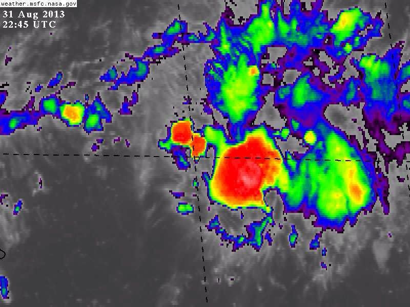
Deep convection now showing up, mabye the beginning of a big red Central Dense Overcast; center is still displaced west.
0 likes
-
USTropics
- Professional-Met
- Posts: 2738
- Joined: Sun Aug 12, 2007 3:45 am
- Location: Florida State University
Re: ATL: INVEST 97L - Discussion
UpTheCreek wrote:USTropics wrote:Unlike the past few disturbances we've been tracking where there's been a vigorous mid level circulation, but nothing able to really get going at the surface, 97L is the opposite.
When you say "we", what does that mean? Are you a pro-met? I see no disclaimers in your posts, just wondering....thanks!
We as in everyone that frequents the storm2k board that has been following the disturbances this year.
0 likes

-
CYCLONE MIKE
- Category 5
- Posts: 2183
- Joined: Tue Aug 31, 2004 6:04 pm
- Location: Gonzales, LA
Re: ATL: INVEST 97L - Discussion
UpTheCreek wrote:USTropics wrote:Unlike the past few disturbances we've been tracking where there's been a vigorous mid level circulation, but nothing able to really get going at the surface, 97L is the opposite.
When you say "we", what does that mean? Are you a pro-met? I see no disclaimers in your posts, just wondering....thanks!
What he said is not opinion it is a fact. The last view invests had nothing going on at the surface no matter how many people argued against it. That is why they looked good on satellite but nothing was at surface. And not speaking for UStropic but I'm sure he meant "we" as in everyone who frequents this forum.
Sorry US didn't see your response
0 likes
-
USTropics
- Professional-Met
- Posts: 2738
- Joined: Sun Aug 12, 2007 3:45 am
- Location: Florida State University
This is one of my favorite enhanced loops, and really gives you a good idea of the overall picture. You can see the ULL turning north of PR/DR which is creating that hostile UL environment right now.
http://www.atmos.washington.edu/~ovens/loops/wxloop.cgi?wv_east_enhanced+12
http://www.atmos.washington.edu/~ovens/loops/wxloop.cgi?wv_east_enhanced+12
0 likes
-
USTropics
- Professional-Met
- Posts: 2738
- Joined: Sun Aug 12, 2007 3:45 am
- Location: Florida State University
Re: ATL: INVEST 97L - Discussion
CYCLONE MIKE wrote:UpTheCreek wrote:USTropics wrote:Unlike the past few disturbances we've been tracking where there's been a vigorous mid level circulation, but nothing able to really get going at the surface, 97L is the opposite.
When you say "we", what does that mean? Are you a pro-met? I see no disclaimers in your posts, just wondering....thanks!
What he said is not opinion it is a fact. The last view invests had nothing going on at the surface no matter how many people argued against it. That is why they looked good on satellite but nothing was at surface. And not speaking for UStropic but I'm sure he meant "we" as in everyone who frequents this forum.
Sorry US didn't see your response
NP and to clarify my meteorology background, I have an AA degree in Meteorology from Daytona State and am currently pursuing my BA at FSU.
0 likes
Who is online
Users browsing this forum: No registered users and 55 guests