ATL: GABRIELLE - Remnants - Discussion

Moderator: S2k Moderators

Message
Author
HurricaneDREW92
Category 1
Category 1
Posts: 320
Age: 26
Joined: Sun Jul 28, 2013 11:56 am
Location: Boston, MA

Re:

#901 Postby HurricaneDREW92 » Wed Sep 04, 2013 2:53 pm

alienstorm wrote:A flight level wind of over 60 mph just reported

Time: 19:30:00Z
Coordinates: 17.0N 65.5167W
Acft. Static Air Press: 971.1 mb (~ 28.68 inHg)
Acft. Geopotential Hgt: 348 meters (~ 1,142 feet)
Extrap. Sfc. Press: 1010.4 mb (~ 29.84 inHg)
D-value: -
Flt. Lvl. Wind (30s): From 97° at 35 knots (From the E at ~ 40.2 mph)
Air Temp: 21.8°C (~ 71.2°F)
Dew Pt: 21.8°C (~ 71.2°F)
Peak (10s) Flt. Lvl. Wind: 36 knots (~ 41.4 mph)
SFMR Peak (10s) Sfc. Wind: 58 knots (~ 66.7 mph)
SFMR Rain Rate: 44 mm/hr (~ 1.73 in/hr)
(*) Denotes suspect data


Surface translation?
0 likes   
This post is NOT AN OFFICIAL FORECAST and should not be used as such. It is just the opinion of the poster and may or may not be backed by sound meteorological data. It is NOT endorsed by any professional institution including storm2k.org. For Official Information please refer to the NHC and NWS products.

-THE ABOVE IS THE OPINION OF DREW ONLY

Aric Dunn
Category 5
Category 5
Posts: 21238
Age: 42
Joined: Sun Sep 19, 2004 9:58 pm
Location: Ready for the Chase.
Contact:

#902 Postby Aric Dunn » Wed Sep 04, 2013 2:53 pm

circ still a little elongated but this pass has better definition.
0 likes   
Note: If I make a post that is brief. Please refer back to previous posts for the analysis or reasoning. I do not re-write/qoute what my initial post said each time.
If there is nothing before... then just ask :)

Space & Atmospheric Physicist, Embry-Riddle Aeronautical University,
I believe the sky is falling...

User avatar
lester
S2K Supporter
S2K Supporter
Posts: 1305
Age: 36
Joined: Sat Aug 27, 2005 5:21 pm
Location: Washington, DC
Contact:

Re:

#903 Postby lester » Wed Sep 04, 2013 2:53 pm

alienstorm wrote:A flight level wind of over 60 mph just reported

Time: 19:30:00Z
Coordinates: 17.0N 65.5167W
Acft. Static Air Press: 971.1 mb (~ 28.68 inHg)
Acft. Geopotential Hgt: 348 meters (~ 1,142 feet)
Extrap. Sfc. Press: 1010.4 mb (~ 29.84 inHg)
D-value: -
Flt. Lvl. Wind (30s): From 97° at 35 knots (From the E at ~ 40.2 mph)
Air Temp: 21.8°C (~ 71.2°F)
Dew Pt: 21.8°C (~ 71.2°F)
Peak (10s) Flt. Lvl. Wind: 36 knots (~ 41.4 mph)
SFMR Peak (10s) Sfc. Wind: 58 knots (~ 66.7 mph)
SFMR Rain Rate: 44 mm/hr (~ 1.73 in/hr)
(*) Denotes suspect data


that sfmr data is rain-contaminated
0 likes   

User avatar
alienstorm
Category 1
Category 1
Posts: 496
Joined: Tue Jul 31, 2007 1:29 pm
Location: Miami Fla western suburb

Re: Re:

#904 Postby alienstorm » Wed Sep 04, 2013 2:54 pm

HurricaneDREW92 wrote:
alienstorm wrote:A flight level wind of over 60 mph just reported

Time: 19:30:00Z
Coordinates: 17.0N 65.5167W
Acft. Static Air Press: 971.1 mb (~ 28.68 inHg)
Acft. Geopotential Hgt: 348 meters (~ 1,142 feet)
Extrap. Sfc. Press: 1010.4 mb (~ 29.84 inHg)
D-value: -
Flt. Lvl. Wind (30s): From 97° at 35 knots (From the E at ~ 40.2 mph)
Air Temp: 21.8°C (~ 71.2°F)
Dew Pt: 21.8°C (~ 71.2°F)
Peak (10s) Flt. Lvl. Wind: 36 knots (~ 41.4 mph)
SFMR Peak (10s) Sfc. Wind: 58 knots (~ 66.7 mph)
SFMR Rain Rate: 44 mm/hr (~ 1.73 in/hr)
(*) Denotes suspect data


Surface translation?


SFMR Peak (10s) Sfc. Wind: 58 knots (~ 66.7 mph)
0 likes   
Personal Forecast Disclaimer:The posts in this forum are NOT official forecast and should not be used as such. They are just the opinion of the poster and may or may not be backed by sound meteorological data. They are NOT endorsed by any professional institution or storm2k.org. For official information, please refer to the NHC and NWS products.

User avatar
'CaneFreak
Category 5
Category 5
Posts: 1486
Joined: Mon Jun 05, 2006 10:50 am
Location: New Bern, NC

#905 Postby 'CaneFreak » Wed Sep 04, 2013 2:54 pm

Aric, convection is popping this afternoon over that low level circulation well to the northeast of 97L as well. HMMMMMMM...

http://www.ssd.noaa.gov/PS/TROP/floaters/97L/imagery/rgb_lalo-animated.gif
0 likes   

RL3AO
Moderator-Pro Met
Moderator-Pro Met
Posts: 16308
Joined: Thu Jun 14, 2007 10:03 pm
Location: NC

Re: Re:

#906 Postby RL3AO » Wed Sep 04, 2013 2:54 pm

alienstorm wrote:SFMR Peak (10s) Sfc. Wind: 58 knots (~ 66.7 mph)


The flight level winds in the one above it (36 knots)
0 likes   

adam0983

Re: Re:

#907 Postby adam0983 » Wed Sep 04, 2013 2:55 pm

What are the odds that the trough will send Invest 97L out to sea? Just an opinion not a forecast.
0 likes   

hurricanes1234
Category 5
Category 5
Posts: 2905
Joined: Sat Jul 28, 2012 6:19 pm
Location: Trinidad and Tobago

Re: ATL: INVEST 97L - Discussion

#908 Postby hurricanes1234 » Wed Sep 04, 2013 2:55 pm

Is the area east of the Bahamas favourable? What is the shear like? :oops:
Last edited by hurricanes1234 on Wed Sep 04, 2013 2:56 pm, edited 1 time in total.
0 likes   
PLEASE NOTE: With the exception of information from weather agencies that I may copy and paste here, my posts will NEVER be official, since I am NOT a meteorologist. They are solely my amateur opinion, and may or may not be accurate. Therefore, please DO NOT use them as official details, particularly when making important decisions. Thank you.

Aric Dunn
Category 5
Category 5
Posts: 21238
Age: 42
Joined: Sun Sep 19, 2004 9:58 pm
Location: Ready for the Chase.
Contact:

Re:

#909 Postby Aric Dunn » Wed Sep 04, 2013 2:56 pm

'CaneFreak wrote:Aric, convection is popping this afternoon over that low level circulation well to the northeast of 97L as well. HMMMMMMM...

http://www.ssd.noaa.gov/PS/TROP/floaters/97L/imagery/rgb_lalo-animated.gif


yeppers... lets see it can become a little more defined ..
0 likes   
Note: If I make a post that is brief. Please refer back to previous posts for the analysis or reasoning. I do not re-write/qoute what my initial post said each time.
If there is nothing before... then just ask :)

Space & Atmospheric Physicist, Embry-Riddle Aeronautical University,
I believe the sky is falling...

Alyono
Professional-Met
Professional-Met
Posts: 6961
Joined: Fri Apr 26, 2013 3:52 pm
Location: Texas Coast

#910 Postby Alyono » Wed Sep 04, 2013 2:57 pm

looks like a super-cell type feature over the center

could lead to short term RI
0 likes   

User avatar
gatorcane
S2K Supporter
S2K Supporter
Posts: 23689
Age: 47
Joined: Sun Mar 13, 2005 3:54 pm
Location: Boca Raton, FL

Re:

#911 Postby gatorcane » Wed Sep 04, 2013 2:59 pm

Alyono wrote:looks like a super-cell type feature over the center

could lead to short term RI

Well I guess the question is not whether is a depression but whether it is a storm or not by the 5pm EST advisory?

You got to think they are going to name this by 5pm EST.
Last edited by gatorcane on Wed Sep 04, 2013 2:59 pm, edited 2 times in total.
0 likes   

User avatar
NDG
S2K Supporter
S2K Supporter
Posts: 15446
Joined: Sun Jul 09, 2006 10:14 pm
Location: Orlando, FL

Re:

#912 Postby NDG » Wed Sep 04, 2013 2:59 pm

Aric Dunn wrote:circ still a little elongated but this pass has better definition.


Also notice that the pressure dropped to 1009mb from 1011mb on the earlier fixed center or windshift
0 likes   

Aric Dunn
Category 5
Category 5
Posts: 21238
Age: 42
Joined: Sun Sep 19, 2004 9:58 pm
Location: Ready for the Chase.
Contact:

Re:

#913 Postby Aric Dunn » Wed Sep 04, 2013 2:59 pm

Alyono wrote:looks like a super-cell type feature over the center

could lead to short term RI


yeah, a hot tower. should also help tighten up the circ.
0 likes   
Note: If I make a post that is brief. Please refer back to previous posts for the analysis or reasoning. I do not re-write/qoute what my initial post said each time.
If there is nothing before... then just ask :)

Space & Atmospheric Physicist, Embry-Riddle Aeronautical University,
I believe the sky is falling...

Aric Dunn
Category 5
Category 5
Posts: 21238
Age: 42
Joined: Sun Sep 19, 2004 9:58 pm
Location: Ready for the Chase.
Contact:

#914 Postby Aric Dunn » Wed Sep 04, 2013 3:01 pm

Doppler velocity showing a better wind profile with the recon location on the line between towards away unlike the earlier wind shift.. also showing 50kt winds at 9000k feet in that tower..
0 likes   
Note: If I make a post that is brief. Please refer back to previous posts for the analysis or reasoning. I do not re-write/qoute what my initial post said each time.
If there is nothing before... then just ask :)

Space & Atmospheric Physicist, Embry-Riddle Aeronautical University,
I believe the sky is falling...

HurriGuy
S2K Supporter
S2K Supporter
Posts: 734
Joined: Thu Aug 15, 2013 8:43 pm
Location: Prairieville, LA

#915 Postby HurriGuy » Wed Sep 04, 2013 3:06 pm

Latest models show that not as many of the models ae recurving.
0 likes   
The posts in this forum are NOT official forecast and should not be used as such. They are just the opinion of the poster and may or may not be backed by sound meteorological data. They are NOT endorsed by any professional institution or storm2k.org. For official information, please refer to the NHC and NWS products.

User avatar
TropicalAnalystwx13
Category 5
Category 5
Posts: 2109
Age: 27
Joined: Tue Jul 19, 2011 8:20 pm
Location: Wilmington, NC
Contact:

#916 Postby TropicalAnalystwx13 » Wed Sep 04, 2013 3:08 pm

97L is beginning to absorb the disturbance to its northeast. This should lead to an increase in size, further exaggerating the flooding event expected over Puerto Rico and perhaps eastern Hispaniola. Both should be preparing for a tropical storm.
0 likes   

SeGaBob

#917 Postby SeGaBob » Wed Sep 04, 2013 3:10 pm

I wonder which computer model the NHC is going to lean towards on their track if they initiate advisories... :)
0 likes   

User avatar
cycloneye
Admin
Admin
Posts: 143899
Age: 68
Joined: Thu Oct 10, 2002 10:54 am
Location: San Juan, Puerto Rico

Re: ATL: INVEST 97L - Discussion

#918 Postby cycloneye » Wed Sep 04, 2013 3:11 pm

BEGIN
NHC_ATCF
invest_RENUMBER_al972013_al072013.ren
FSTDA
R
U
040
010
0000
201309042009
NONE
NOTIFY
0 likes   
Visit the Caribbean-Central America Weather Thread where you can find at first post web cams,radars
and observations from Caribbean basin members Click Here

User avatar
NDG
S2K Supporter
S2K Supporter
Posts: 15446
Joined: Sun Jul 09, 2006 10:14 pm
Location: Orlando, FL

Re: ATL: INVEST 97L - Discussion

#919 Postby NDG » Wed Sep 04, 2013 3:12 pm

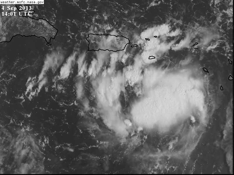
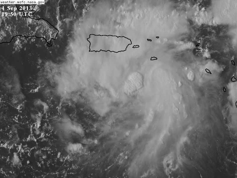
In just 6 hours 97L is organized better fairly fast.

Image
Image
0 likes   

torrea40

Re: ATL: INVEST 97L - Discussion

#920 Postby torrea40 » Wed Sep 04, 2013 3:13 pm

cycloneye wrote:BEGIN
NHC_ATCF
invest_RENUMBER_al972013_al072013.ren
FSTDA
R
U
040
010
0000
201309042009
NONE
NOTIFY


It's a Depression.??????
0 likes   


Return to “2013”

Who is online

Users browsing this forum: No registered users and 40 guests