http://tropic.ssec.wisc.edu/real-time/salmain.php?&prod=wvmid&time=
that tells alot. humberto faces huge obstacles even if it briefly becomes a cane. you can see the persistent trof along nw africa that has turned it nw. also, the dry air is just north of it, and to its nw is a strong upper low that appears stationary.
ATL: HUMBERTO - Remnants - Discussion
Moderator: S2k Moderators
-
ninel conde
Re: ATL: HUMBERTO - Tropical Storm - Discussion
Last edited by tolakram on Tue Sep 10, 2013 9:17 pm, edited 1 time in total.
Reason: added URL tags
Reason: added URL tags
0 likes
-
ozonepete
- Professional-Met

- Posts: 4743
- Joined: Mon Sep 07, 2009 3:23 pm
- Location: From Ozone Park, NYC / Now in Brooklyn, NY
Re: Re:
hurricanes1234 wrote:bahamaswx wrote:Beautiful outflow and banding in some of those shots from earlier.
This may be a silly question, but why, then, did the pressure rise to 995 mbar? I can't tell if it's weakening or strengthening.
You are talking about estimates. A 2mb difference in estimates is not significant. 993mb = 29.32 inches. 995mb = 29.38 inches.
0 likes

Re: ATL: HUMBERTO - Tropical Storm - Discussion
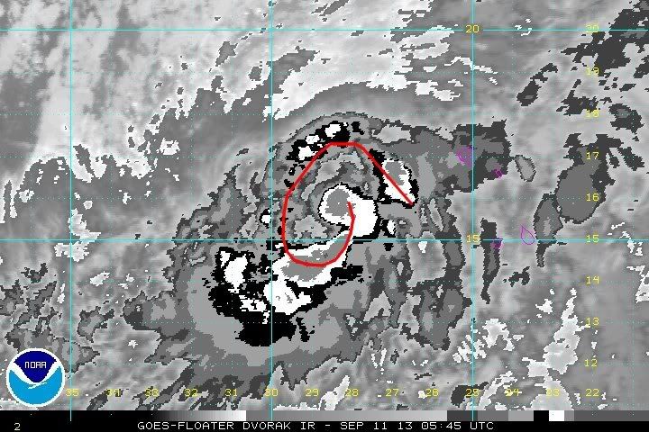
It appears that the weakening earlier was DMIN in addition to the dry air, as it looks like the outer bands are reforming and there has been a -80C blowup right near the circulation center, so it may be trying to reform a southern eyewall.
http://rammb.cira.colostate.edu/products/tc_realtime/loop.asp?product=4kmirimg&storm_identifier=AL092013&starting_image=2013AL09_4KMIRIMG_201309102015.GIF
And is it possible that the trough to the northwest, if no more dry air mixes in, could provide a strong outflow channel?
http://rammb.cira.colostate.edu/products/tc_realtime/loop.asp?product=4kmirimg&storm_identifier=AL092013&starting_image=2013AL09_4KMIRIMG_201309102015.GIF
And is it possible that the trough to the northwest, if no more dry air mixes in, could provide a strong outflow channel?
0 likes
The above post is not official and should not be used as such. It is the opinion of the poster and may or may not be backed by sound meteorological data. It is not endorsed by any professional institution or storm2k.org. For official information, please refer to the NHC and NWS products.
-
ozonepete
- Professional-Met
- Posts: 4743
- Joined: Mon Sep 07, 2009 3:23 pm
- Location: From Ozone Park, NYC / Now in Brooklyn, NY
Re: ATL: HUMBERTO - Tropical Storm - Discussion
Hammy wrote:It appears that the weakening earlier was DMIN in addition to the dry air, as it looks like the outer bands are reforming and there has been a -80C blowup right near the circulation center, so it may be trying to reform a southern eyewall.
http://rammb.cira.colostate.edu/products/tc_realtime/loop.asp?product=4kmirimg&storm_identifier=AL092013&starting_image=2013AL09_4KMIRIMG_201309102015.GIF
And is it possible that the trough to the northwest, if no more dry air mixes in, could provide a strong outflow channel?
Nice observation.
0 likes
-
cycloneye

- Admin

- Posts: 149696
- Age: 69
- Joined: Thu Oct 10, 2002 10:54 am
- Location: San Juan, Puerto Rico
Re: ATL: HUMBERTO - Tropical Storm - Discussion
BULLETIN
TROPICAL STORM HUMBERTO ADVISORY NUMBER 10
NWS NATIONAL HURRICANE CENTER MIAMI FL AL092013
1100 PM AST TUE SEP 10 2013
...HUMBERTO REMAINS A TROPICAL STORM OVER THE EASTERN ATLANTIC
OCEAN...
SUMMARY OF 1100 PM AST...0300 UTC...INFORMATION
-----------------------------------------------
LOCATION...15.4N 28.4W
ABOUT 270 MI...435 KM W OF THE SOUTHERNMOST CAPE VERDE ISLANDS
MAXIMUM SUSTAINED WINDS...70 MPH...110 KM/H
PRESENT MOVEMENT...NW OR 315 DEGREES AT 7 MPH...11 KM/H
MINIMUM CENTRAL PRESSURE...995 MB...29.38 INCHES
Read 11 PM Discussion here.
0 likes
Visit the Caribbean-Central America Weather Thread where you can find at first post web cams,radars
and observations from Caribbean basin members Click Here
and observations from Caribbean basin members Click Here
-
hurricanes1234
- Category 5

- Posts: 2908
- Joined: Sat Jul 28, 2012 6:19 pm
- Location: Trinidad and Tobago
Re: ATL: HUMBERTO - Tropical Storm - Discussion
This storm should at least become 75 mph. I can't see why it wouldn't intensify, it's had the best conditions so far for any storm this year. This year has been a real mystery.
The posts in this forum are NOT official forecast and should not be used as such. They are just the opinion of the poster and may or may not be backed by sound meteorological data. They are NOT endorsed by any professional institution or storm2k.org. For official information, please refer to the NHC and NWS products.
The posts in this forum are NOT official forecast and should not be used as such. They are just the opinion of the poster and may or may not be backed by sound meteorological data. They are NOT endorsed by any professional institution or storm2k.org. For official information, please refer to the NHC and NWS products.
0 likes
PLEASE NOTE: With the exception of information from weather agencies that I may copy and paste here, my posts will NEVER be official, since I am NOT a meteorologist. They are solely my amateur opinion, and may or may not be accurate. Therefore, please DO NOT use them as official details, particularly when making important decisions. Thank you.
-
TheStormExpert
Re: ATL: HUMBERTO - Tropical Storm - Discussion
hurricanes1234 wrote:This storm should at least become 75 mph. I can't see why it wouldn't intensify, it's had the best conditions so far for any storm this year. This year has been a real mystery.
The posts in this forum are NOT official forecast and should not be used as such. They are just the opinion of the poster and may or may not be backed by sound meteorological data. They are NOT endorsed by any professional institution or storm2k.org. For official information, please refer to the NHC and NWS products.
I'm starting to have the feeling that this will be our longest lived and strongest storm of the season.
0 likes
Re: ATL: HUMBERTO - Tropical Storm - Discussion
The record might be broken. Humberto is showing signs of having gulped dry and slightly stumbling.
0 likes

Re: ATL: HUMBERTO - Tropical Storm - Discussion
Sanibel wrote:The record might be broken. Humberto is showing signs of having gulped dry and slightly stumbling.
Can you link to something showing this?
0 likes
Personal Forecast Disclaimer:
The posts in this forum are NOT official forecast and should not be used as such. They are just the opinion of the poster and may or may not be backed by sound meteorological data. They are NOT endorsed by any professional institution or storm2k.org. For official information, please refer to the NHC and NWS products.
The posts in this forum are NOT official forecast and should not be used as such. They are just the opinion of the poster and may or may not be backed by sound meteorological data. They are NOT endorsed by any professional institution or storm2k.org. For official information, please refer to the NHC and NWS products.
-
Andrew92

- S2K Supporter

- Posts: 3247
- Age: 42
- Joined: Mon Jun 16, 2003 12:35 am
- Location: Phoenix, Arizona
AL, 09, 2013091106, , BEST, 0, 156N, 287W, 60, 995, TS, 34, NEQ, 100, 80, 50, 80, 1012, 400, 20, 0, 0, L, 0, , 0, 0, HUMBERTO, D,
AL, 09, 2013091106, , BEST, 0, 156N, 287W, 60, 995, TS, 50, NEQ, 50, 40, 30, 40, 1012, 400, 20, 0, 0, L, 0, , 0, 0, HUMBERTO, D,
Still a tropical storm. New record coming?
-Andrew92
AL, 09, 2013091106, , BEST, 0, 156N, 287W, 60, 995, TS, 50, NEQ, 50, 40, 30, 40, 1012, 400, 20, 0, 0, L, 0, , 0, 0, HUMBERTO, D,
Still a tropical storm. New record coming?
-Andrew92
0 likes

-
WeatherGuesser
- Category 5
- Posts: 2672
- Joined: Tue Jun 29, 2010 6:46 am
-
Extratropical94

- Professional-Met
- Posts: 3545
- Age: 31
- Joined: Wed Oct 20, 2010 6:36 am
- Location: Hamburg, Germany
- Contact:
Sorry guys...
The only hope now is that they might not adjust the 06z Best Track data and leave it like it is in post-season analysis.
...HUMBERTO BECOMES THE FIRST HURRICANE OF THE SEASON OVER THE FAR
EASTERN ATLANTIC...
SUMMARY OF 500 AM AST...0900 UTC...INFORMATION
----------------------------------------------
LOCATION...16.0N 28.9W
ABOUT 310 MI...500 KM WNW OF THE SOUTHERNMOST CAPE VERDE ISLANDS
MAXIMUM SUSTAINED WINDS...75 MPH...120 KM/H
PRESENT MOVEMENT...NNW OR 330 DEGREES AT 8 MPH...13 KM/H
MINIMUM CENTRAL PRESSURE...992 MB...29.29 INCHES
0 likes
54° 11' 59'' N, 9° 9' 20'' E
Boomer Sooner!
Go Broncos! Go Cards!
Clinching counties, one at a time: https://mob-rule.com/user-gifs/USA/xtrp94.gif
- Daniel
Boomer Sooner!
Go Broncos! Go Cards!
Clinching counties, one at a time: https://mob-rule.com/user-gifs/USA/xtrp94.gif
- Daniel


-
hurricanes1234
- Category 5
- Posts: 2908
- Joined: Sat Jul 28, 2012 6:19 pm
- Location: Trinidad and Tobago
Re: ATL: HUMBERTO - Hurricane - Discussion
Well, congratulations, Humberto! 
0 likes
PLEASE NOTE: With the exception of information from weather agencies that I may copy and paste here, my posts will NEVER be official, since I am NOT a meteorologist. They are solely my amateur opinion, and may or may not be accurate. Therefore, please DO NOT use them as official details, particularly when making important decisions. Thank you.


-
Stephanie

- S2K Supporter
- Posts: 23843
- Age: 63
- Joined: Thu Feb 06, 2003 9:53 am
- Location: Glassboro, NJ
Re: ATL: HUMBERTO - Hurricane - Discussion
Welcome Humberto! Just stay a fish.
I'm surprised that he made a left turn. Still looks too high on the longitude to be an issue for this side of the pond.
I'm surprised that he made a left turn. Still looks too high on the longitude to be an issue for this side of the pond.
0 likes
Who is online
Users browsing this forum: No registered users and 79 guests