Global model runs discussion

Moderator: S2k Moderators

Message
Author
ninel conde

Re: Re:

#6421 Postby ninel conde » Fri Sep 13, 2013 2:13 pm

LarryWx wrote:
ninel conde wrote:06GFS has a low off the coast at 240 but it just scoots offshore. if a high were locked in and the low hung around it might amount to something. my prediction of no cane landfalls this season looks sweet.


Every run will be different especially if you're talking 10+ days out. I am just looking for trends and all signs point to much stronger ridging then we've been seeing so far this month. We shall see if it is able to lock in more, timing is always crucial when it comes to land falling systems as well.


Ninel is making a good point here. Early month GFS runs were suggesting NE US ridging locking in and dominating 9/15-22. Since then, there has been plenty of delay and now they're hedging on NE ridging taking over even during late month. As a result, the 0z-12Z GFS runs of today dropped the late Sep. SE US cyclone threat. Let's see if the modeled threat returns.[/quote]

true, and im far from impressed about how the euro says oct will be favorable for east gom. east coast landfalls. winter like pattern is setting up and the ridge just keeps getting delayed. pattern persistence says not going to happen.
0 likes   

tolakram
Admin
Admin
Posts: 20009
Age: 62
Joined: Sun Aug 27, 2006 8:23 pm
Location: Florence, KY (name is Mark)

Re: Global Model Runs Discussion

#6422 Postby tolakram » Fri Sep 13, 2013 2:51 pm

Was any data used to make any those predictions? I agree with the results, but I could have said the same thing 2 months ago and then claimed I was right because it came true.

That does not make me correct, it means I guessed correctly. I get no satisfaction from making correct guesses.

So why are you unimpressed? Are you simply taking a persistent pattern and figuring it will probably continue? If so, why? And if you know why, then what would it take to break the pattern?

If any of those answers are 'I don't know' then hey, that's ok, but you have to come right out and admit it's a guess.
0 likes   
M a r k
- - - - -
Join us in chat: Storm2K Chatroom Invite. Android and IOS apps also available.

The posts in this forum are NOT official forecasts and should not be used as such. Posts are NOT endorsed by any professional institution or STORM2K.org. For official information and forecasts, please refer to NHC and NWS products.

User avatar
PTrackerLA
Category 5
Category 5
Posts: 5277
Age: 41
Joined: Thu Oct 10, 2002 8:40 pm
Location: Lafayette, LA

Re: Global Model Runs Discussion

#6423 Postby PTrackerLA » Fri Sep 13, 2013 3:10 pm

I can't post the link from Alan's site but the 12z Euro shows another low pressue developing in the BOC and starting to move eastward by 240 hrs. Shows up much better on the vorticity image than here if someone has a free image to share. Could be something to watch...

Image
0 likes   

User avatar
crownweather
S2K Supporter
S2K Supporter
Posts: 595
Age: 50
Joined: Sat Aug 12, 2006 9:21 am
Location: Sturbridge, Massachusetts
Contact:

Re: Global Model Runs Discussion

#6424 Postby crownweather » Fri Sep 13, 2013 3:17 pm

PTrackerLA wrote:I can't post the link from Alan's site but the 12z Euro shows another low pressue developing in the BOC and starting to move eastward by 240 hrs. Shows up much better on the vorticity image than here if someone has a free image to share. Could be something to watch...

Image


It actually looks like some of the energy from Ingrid is left behind (which the GFS ensemble has been hinting at for last few days). This leftover energy looks to lead to additional mischief. The Gulf looks to be the place to watch for the next couple of weeks.

Image

Uploaded with ImageShack.us
0 likes   
Rob Lightbown
Crown Weather Services
https://crownweather.com

User avatar
ROCK
Category 5
Category 5
Posts: 9484
Age: 54
Joined: Tue Aug 17, 2004 7:30 am
Location: Kemah, Texas

Re: Global Model Runs Discussion

#6425 Postby ROCK » Fri Sep 13, 2013 4:10 pm

12Z CMC is showing the same thing :uarrow: as the EURO in long run.....GFS also to some extent thats 2 big boys and 1 teenager model sniffing something out in the long range.

oh is there room in here? I am about done with watching Ingrid!!
0 likes   

User avatar
PTrackerLA
Category 5
Category 5
Posts: 5277
Age: 41
Joined: Thu Oct 10, 2002 8:40 pm
Location: Lafayette, LA

Re: Global Model Runs Discussion

#6426 Postby PTrackerLA » Fri Sep 13, 2013 4:28 pm

ROCK good catch didn't even think to look at CMC:

12z CMC 9/13/13

240hrs
Image
0 likes   

User avatar
ROCK
Category 5
Category 5
Posts: 9484
Age: 54
Joined: Tue Aug 17, 2004 7:30 am
Location: Kemah, Texas

Re: Global Model Runs Discussion

#6427 Postby ROCK » Fri Sep 13, 2013 4:57 pm

lol...I have too much time on my hands....
0 likes   

User avatar
gatorcane
S2K Supporter
S2K Supporter
Posts: 23691
Age: 47
Joined: Sun Mar 13, 2005 3:54 pm
Location: Boca Raton, FL

#6428 Postby gatorcane » Fri Sep 13, 2013 7:30 pm

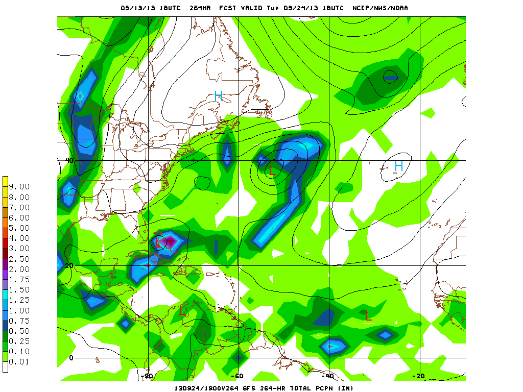
The 18Z GFS is showing something forming in the NW Caribbean and moving NE at 240 hours:

Image

24 Hours later (264 hours):

Image
0 likes   

TheStormExpert

Re:

#6429 Postby TheStormExpert » Fri Sep 13, 2013 8:20 pm

gatorcane wrote:The 18Z GFS is showing something forming in the NW Caribbean and moving NE at 240 hours:

http://img23.imageshack.us/img23/2977/oaw.gif

24 Hours later (264 hours):

http://i1276.photobucket.com/albums/y47 ... ca760c.gif

The GFS has been showing systems forming in the NW Caribbean and tracking NE out into the open Atlantic or up the East Coast off and on for about the past week.
0 likes   

User avatar
Hurricaneman
Category 5
Category 5
Posts: 7351
Age: 45
Joined: Tue Aug 31, 2004 3:24 pm
Location: central florida

#6430 Postby Hurricaneman » Sat Sep 14, 2013 12:34 am

the 0zGFS shows at hr 204 a low forming north of Houndoras and slides it up to the Florida straits at 240 as a strung out wave so this is an area that needs to be watched the next week to 10 days

The posts in this forum are NOT official forecast and should not be used as such. They are just the opinion of the poster and may or may not be backed by sound meteorological data. They are NOT endorsed by any professional institution or storm2k.org. For official information, please refer to the NHC and NWS products
0 likes   

User avatar
CourierPR
Category 5
Category 5
Posts: 1335
Age: 71
Joined: Tue Aug 31, 2004 7:53 pm
Location: Pompano Beach, Florida

Re: Global Model Runs Discussion

#6431 Postby CourierPR » Sat Sep 14, 2013 5:18 am

Hurricaneman, that would seem to jive with Joe Bastardi's tweet yesterday about the Brazilian meteogram showing low pressure near Miami around that time.
0 likes   

User avatar
gatorcane
S2K Supporter
S2K Supporter
Posts: 23691
Age: 47
Joined: Sun Mar 13, 2005 3:54 pm
Location: Boca Raton, FL

#6432 Postby gatorcane » Sat Sep 14, 2013 7:49 am

06Z GFS continues to show this NW Caribbean system developing and heading NE. The timeframe is coming in a little each run:

192 Hours:
Image

252 Hours:
Image
Last edited by gatorcane on Sat Sep 14, 2013 8:03 am, edited 3 times in total.
0 likes   

User avatar
gatorcane
S2K Supporter
S2K Supporter
Posts: 23691
Age: 47
Joined: Sun Mar 13, 2005 3:54 pm
Location: Boca Raton, FL

#6433 Postby gatorcane » Sat Sep 14, 2013 7:52 am

The 00Z ECMWF develops another BOC low moves it NE then ENE across the GOM:

120 Hours:
Image

240 Hours:
Image
0 likes   

HURRICANELONNY
Category 5
Category 5
Posts: 1383
Joined: Wed May 07, 2003 6:48 am
Location: HOLLYWOOD.FL

Re: Global Model Runs Discussion

#6434 Postby HURRICANELONNY » Sat Sep 14, 2013 1:14 pm

The models were showing pressure anomolies dropping from carribean to gulf in long range. So thats probably why there popping storms everywhere. Have to see if anything forms in about a week :eek:
0 likes   
hurricanelonny

supercane4867
Category 5
Category 5
Posts: 4966
Joined: Wed Nov 14, 2012 10:43 am

Re: Global Model Runs Discussion

#6435 Postby supercane4867 » Sat Sep 14, 2013 2:22 pm

12Z ECMWF

Huge storm developing from the Gulf

Image
Image
0 likes   

User avatar
gatorcane
S2K Supporter
S2K Supporter
Posts: 23691
Age: 47
Joined: Sun Mar 13, 2005 3:54 pm
Location: Boca Raton, FL

#6436 Postby gatorcane » Sat Sep 14, 2013 2:32 pm

Another look at the 12Z ECMWF:

A rather strange track with this one. The GFS has been showing the area getting going further south in the NW Caribbean and tracking NE:

216 hours:
Image

240 hours:
Image

12Z GFS 240 hours take it through the FL Straits and into the Bahamas:

Image
0 likes   

User avatar
LaBreeze
Category 5
Category 5
Posts: 1497
Joined: Thu Sep 04, 2003 1:57 pm
Location: SW Louisiana

Re: Global Model Runs Discussion

#6437 Postby LaBreeze » Sat Sep 14, 2013 4:21 pm

Once again the ridge would be what would send this NE then ENE?
0 likes   
Audrey (1957), Carla (1961), Hilda (1964), Betsy (1965), Edith (1971), Carmen (1974), Danny (1985), Juan (1985), Andrew (1992), Lili (2002), Rita (2005), Gustav (2008), Ike (2008), and stuck in the eye of Iniki (1992) while vacationing in Kauai.

Not an official forecast by any means.

ninel conde

#6438 Postby ninel conde » Sat Sep 14, 2013 4:31 pm

ridge almost in a blocking position as the overall pattern is going to change.
0 likes   

User avatar
LaBreeze
Category 5
Category 5
Posts: 1497
Joined: Thu Sep 04, 2003 1:57 pm
Location: SW Louisiana

Re:

#6439 Postby LaBreeze » Sat Sep 14, 2013 6:52 pm

ninel conde wrote:ridge almost in a blocking position as the overall pattern is going to change.

Overall pattern is going to change how? Is the ridge going to hold firm?
0 likes   
Audrey (1957), Carla (1961), Hilda (1964), Betsy (1965), Edith (1971), Carmen (1974), Danny (1985), Juan (1985), Andrew (1992), Lili (2002), Rita (2005), Gustav (2008), Ike (2008), and stuck in the eye of Iniki (1992) while vacationing in Kauai.

Not an official forecast by any means.

Steve H.
Category 5
Category 5
Posts: 2146
Joined: Sat Oct 19, 2002 9:06 am
Location: Palm Bay, Florida

Re: Global Model Runs Discussion

#6440 Postby Steve H. » Sat Sep 14, 2013 6:59 pm

No not really. It looks like it takes it across SW Florida and off shore the East Central Florida coast.
0 likes   


Return to “2015”

Who is online

Users browsing this forum: No registered users and 3 guests