Texas Fall 2013
Moderator: S2k Moderators
Forum rules

The posts in this forum are NOT official forecast and should not be used as such. They are just the opinion of the poster and may or may not be backed by sound meteorological data. They are NOT endorsed by any professional institution or STORM2K.
-
joshskeety
- Tropical Storm

- Posts: 225
- Joined: Tue Jan 13, 2004 5:58 pm
- Location: Springtown, Texas
-
downsouthman1
- Category 2

- Posts: 706
- Age: 46
- Joined: Fri Jan 07, 2011 8:14 pm
- Location: Rowlett, TX
Re:
joshskeety wrote:at 36h.. So far spitting image of 12z run..
It's been too long since I've looked at this stuff. How are temps derived? I thought it had something to do with the 540 thickness line indicating approximately 100% humidity but I could be way off. Like that's where atmospheric temps @ 500MB are freezing?
Last edited by downsouthman1 on Thu Nov 21, 2013 3:23 pm, edited 2 times in total.
0 likes
Not a professional MET! My posts are merely speculation.
-
joshskeety
- Tropical Storm
- Posts: 225
- Joined: Tue Jan 13, 2004 5:58 pm
- Location: Springtown, Texas
Re: Re:
downsouthman1 wrote:joshskeety wrote:at 36h.. So far spitting image of 12z run..
It's been too long since I've looked at this stuff. How are temps derived? I thought it had something to do with the 540 thickness line indicating approximately 100% humidity but I could be way off.
Well I always just use the 850mb 0 line for quick viewing of the previous hours.. So if I am looking at 36h on a 3 hour run, I look at the 850mb line on the 33h run and use that determination.. Then if that shows rain/snow, Ill check the skew-t model on that run to double check all layers of the atmosphere..
As far as Temps, the NWS only gives us a small amount of data the NAM runs, but other sites can calculate temp at the surface much better than you will get from the NWS site.. But sometimes you have to wait for that data to port over to someone else's map systems and it can be longer.. But using the formula above, its a good poor man's way of determining what the precip will be.. The Skew-T maps are your biggest friend..
0 likes
-
downsouthman1
- Category 2
- Posts: 706
- Age: 46
- Joined: Fri Jan 07, 2011 8:14 pm
- Location: Rowlett, TX
Re: Re:
Never learned to read those lol.joshskeety wrote:downsouthman1 wrote:joshskeety wrote:at 36h.. So far spitting image of 12z run..
It's been too long since I've looked at this stuff. How are temps derived? I thought it had something to do with the 540 thickness line indicating approximately 100% humidity but I could be way off.
Well I always just use the 850mb 0 line for quick viewing of the previous hours.. So if I am looking at 36h on a 3 hour run, I look at the 850mb line on the 33h run and use that determination.. Then if that shows rain/snow, Ill check the skew-t model on that run to double check all layers of the atmosphere..
As far as Temps, the NWS only gives us a small amount of data the NAM runs, but other sites can calculate temp at the surface much better than you will get from the NWS site.. But sometimes you have to wait for that data to port over to someone else's map systems and it can be longer.. But using the formula above, its a good poor man's way of determining what the precip will be.. The Skew-T maps are your biggest friend..
0 likes
Not a professional MET! My posts are merely speculation.
-
joshskeety
- Tropical Storm
- Posts: 225
- Joined: Tue Jan 13, 2004 5:58 pm
- Location: Springtown, Texas
-
wxman57

- Moderator-Pro Met

- Posts: 23170
- Age: 68
- Joined: Sat Jun 21, 2003 8:06 pm
- Location: Houston, TX (southwest)
Re: Re:
Portastorm wrote::uarrow:
I think that you have to ask yourself why is the NAM forecasting such a snow event? Well, because the NAM is thinking this cold core upper low will stay intact and be a strong one. That will create an atmospheric profile, vertically, which would support snow for those underneath the low as it moves across the state. These upper lows are hard to forecast, joshskeety, and I don't think NWSFO Dallas/Fort Worth wants to go "all in" just yet until they see more model support. I actually would do what they're doing.
OK, I see that wxman57 is here now. He'll set us all straight!
I'm pretty confident the front will stall way to our north and the temperature will reach the mid 80s in Houston this weekend.
One difference I do see here (vs. 1993) is that back in 1993, the GFS forecast a similar pattern but forecast the cold front to stall near Dallas then retreat to the north to Kansas by the 25th. Actually, the front was in the Gulf on Nov. 25th of 1993. This time, at least, the GFS is doing much better and forecasting the front to blast on through to the Gulf. Looking at the forecast soundings for Austin, the GFS indicates temps way above freezing just above the surface Sunday/Monday (upper 40s). Can't rule out a little sleet as the precip ends, though.
0 likes
-
Tireman4

- S2K Supporter

- Posts: 5903
- Age: 60
- Joined: Fri Jun 30, 2006 1:08 pm
- Location: Humble, Texas
- Contact:
Re: Re:
wxman57 wrote:Portastorm wrote::uarrow:
I think that you have to ask yourself why is the NAM forecasting such a snow event? Well, because the NAM is thinking this cold core upper low will stay intact and be a strong one. That will create an atmospheric profile, vertically, which would support snow for those underneath the low as it moves across the state. These upper lows are hard to forecast, joshskeety, and I don't think NWSFO Dallas/Fort Worth wants to go "all in" just yet until they see more model support. I actually would do what they're doing.
OK, I see that wxman57 is here now. He'll set us all straight!
wxman57 wrote:I'm pretty confident the front will stall way to our north and the temperature will reach the mid 80s in Houston this weekend.
Ha ha ha. No.
0 likes
-
Longhornmaniac8

- Category 1

- Posts: 261
- Joined: Thu Nov 18, 2010 2:30 am
- Location: Austin, TX
Re:
joshskeety wrote:Btw.. 48h out still spitting images.. If anything I would say they are about an hour difference or so slower (low placement) than the 12z run..
You're right. It looks like it's just a touch slower, and looks like it digs south by about the same amount that it's slower, which is to say, virtually nothing.
Cheers,
Cameron
0 likes
-
joshskeety
- Tropical Storm
- Posts: 225
- Joined: Tue Jan 13, 2004 5:58 pm
- Location: Springtown, Texas
Now we are getting the meat and potatoes.. NAM is definitely warmer and less moist so far to 60h out, but this is when the low began to backfill on the 12z run.. 0 line at 60h is sitting just northwest of the DFW metroplex say around Jacksboro, Texas where it is at 57h as well.. Still in line, but definitely not as cold and not as moist on this run so far.. GFS just may pull this one out or as I first figured they will converge...
0 likes
-
Rgv20

- S2K Supporter
- Posts: 2466
- Age: 39
- Joined: Wed Jan 05, 2011 5:42 pm
- Location: Edinburg/McAllen Tx
From an expected high of 91 this afternoon to a forecast high of 44 on Sunday, Gotta love Texas weather huh? lol

Uploaded with ImageShack.us

Uploaded with ImageShack.us
0 likes
The following post is NOT an official forecast and should not be used as such. It is just the opinion of the poster and may or may not be backed by sound meteorological data. It is NOT endorsed by any professional institution including storm2k.org For Official Information please refer to the NHC and NWS products.
-
joshskeety
- Tropical Storm
- Posts: 225
- Joined: Tue Jan 13, 2004 5:58 pm
- Location: Springtown, Texas
Btw, if the Front continues its path it should hit Wichita Falls in the next half hour or so. Clearing is happening now here in Downtown Ft. Worth and the instability is going off the chart. I would expect Thunderstorms to begin to develop somewhere between Wichita Falls and Jacksboro within the next 1 to 2 hours.. FYI..
0 likes
-
downsouthman1
- Category 2
- Posts: 706
- Age: 46
- Joined: Fri Jan 07, 2011 8:14 pm
- Location: Rowlett, TX
Re: Texas Fall 2013
NAM 18Z run Hours 66+ are wetter than the 12Z run along the I35 corridor. It has also slowed down the precip onset & duration times.
Last edited by downsouthman1 on Thu Nov 21, 2013 3:54 pm, edited 2 times in total.
0 likes
Not a professional MET! My posts are merely speculation.
-
Portastorm

- Storm2k Moderator

- Posts: 9954
- Age: 63
- Joined: Fri Jul 11, 2003 9:16 am
- Location: Round Rock, TX
- Contact:
Re: Texas Fall 2013
As of 2:45 pm, front is through Lubbock. Temperature drop of close to 10 degrees in 20 minutes. North winds gusting to near 40 now with blowing dust.
0 likes
Any forecasts under my name are to be taken with a grain of salt. Get your best forecasts from the National Weather Service and National Hurricane Center.
-
joshskeety
- Tropical Storm
- Posts: 225
- Joined: Tue Jan 13, 2004 5:58 pm
- Location: Springtown, Texas
Wow, just like last run.. Major ice storm in San Antonio/Austin.. If you take a line from Ft. Worth to Fredericksburg west from a line of Abilene to Big Lake it shows ALL SNOW and heavy snow at that..
No way that can ignore this any longer.. This potentially could be a very dangerous situation in central Texas.. When I see below freezing precip from .75 to 1.5 inches as the NAM is indicating in the form of freezing rain or sleet on the east side and 6-10 inch snows on the west side you can't ignore it any longer.. This is the 3rd run in a row..
No way that can ignore this any longer.. This potentially could be a very dangerous situation in central Texas.. When I see below freezing precip from .75 to 1.5 inches as the NAM is indicating in the form of freezing rain or sleet on the east side and 6-10 inch snows on the west side you can't ignore it any longer.. This is the 3rd run in a row..
0 likes

Re: Re:
Tireman4 wrote:wxman57 wrote:Portastorm wrote::uarrow:
I think that you have to ask yourself why is the NAM forecasting such a snow event? Well, because the NAM is thinking this cold core upper low will stay intact and be a strong one. That will create an atmospheric profile, vertically, which would support snow for those underneath the low as it moves across the state. These upper lows are hard to forecast, joshskeety, and I don't think NWSFO Dallas/Fort Worth wants to go "all in" just yet until they see more model support. I actually would do what they're doing.
OK, I see that wxman57 is here now. He'll set us all straight!
I'm pretty confident the front will stall way to our north and the temperature will reach the mid 80s in Houston this weekend.
Ha ha ha. No.
Pffffffffffffft!!!!!!!! I almost spewed beer onto my keyboard!!!! Sorry but that was funny!
0 likes
Personal Forecast Disclaimer:
The posts in this forum are NOT official forecast and should not be used as such. They are just the opinion of the poster and may or may not be backed by sound meteorological data. They are NOT endorsed by any professional institution or storm2k.org. For official information, please refer to the NHC and NWS products.
The posts in this forum are NOT official forecast and should not be used as such. They are just the opinion of the poster and may or may not be backed by sound meteorological data. They are NOT endorsed by any professional institution or storm2k.org. For official information, please refer to the NHC and NWS products.


Re: Texas Fall 2013
Portastorm wrote:Kelarie wrote:Can you give me input on what the weather situation looks like for Texarkana? Thanks!
Time frame, please?
Saturday through Monday. Sorry for missing that.
0 likes
-
joshskeety
- Tropical Storm
- Posts: 225
- Joined: Tue Jan 13, 2004 5:58 pm
- Location: Springtown, Texas
-
Rgv20
- S2K Supporter
- Posts: 2466
- Age: 39
- Joined: Wed Jan 05, 2011 5:42 pm
- Location: Edinburg/McAllen Tx
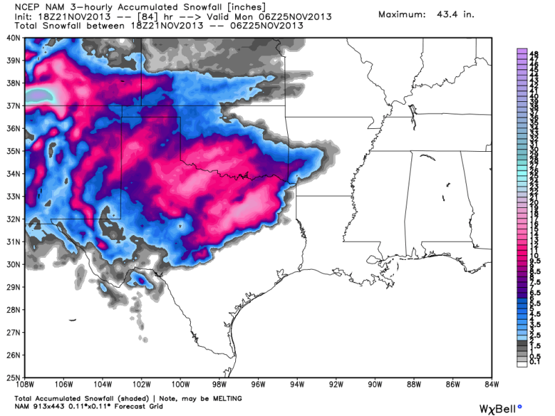
18zNAM brought to you by Snow Apocalypse November 2013.... 

0 likes
The following post is NOT an official forecast and should not be used as such. It is just the opinion of the poster and may or may not be backed by sound meteorological data. It is NOT endorsed by any professional institution including storm2k.org For Official Information please refer to the NHC and NWS products.
-
Portastorm
- Storm2k Moderator
- Posts: 9954
- Age: 63
- Joined: Fri Jul 11, 2003 9:16 am
- Location: Round Rock, TX
- Contact:
Re:
joshskeety wrote:Holy cow and add another 6-10 inches on the backside of this if you life in northwest Texas if this model is right.. No way I believe 2 feet of pure snow in North Texas in mid november.. No friggen way..
Just a friendly reminder that the NAM has been, and continues to be, the outlier of the model solutions. If you go over to NOAA's Weather Prediction Center page and look over the discussions, you'll see that. The expect forecasters believe it ejects the upper low way too fast. Among other things.
0 likes
Any forecasts under my name are to be taken with a grain of salt. Get your best forecasts from the National Weather Service and National Hurricane Center.
Return to “USA & Caribbean Weather”
Who is online
Users browsing this forum: No registered users and 18 guests