
ENSO Updates (2007 thru 2023)
Moderator: S2k Moderators
Forum rules

The posts in this forum are NOT official forecasts and should not be used as such. They are just the opinion of the poster and may or may not be backed by sound meteorological data. They are NOT endorsed by any professional institution or STORM2K. For official information, please refer to products from the National Hurricane Center and National Weather Service.
-
cycloneye

- Admin

- Posts: 149464
- Age: 69
- Joined: Thu Oct 10, 2002 10:54 am
- Location: San Juan, Puerto Rico
Re: ENSO: CPC 3/6/14 March update=El Nino watch issued
Here is a good graphic of how it has been the evolution of the large warm pool in the subsurface and how the cold blue waters have been shrinking as time goes by.
0 likes
Visit the Caribbean-Central America Weather Thread where you can find at first post web cams,radars
and observations from Caribbean basin members Click Here
and observations from Caribbean basin members Click Here
-
cycloneye
- Admin
- Posts: 149464
- Age: 69
- Joined: Thu Oct 10, 2002 10:54 am
- Location: San Juan, Puerto Rico
Re: ENSO: CPC 3/6/14 March update=El Nino watch issued
Look how the blue cold waters are shrinking west of South America as the warm waters expand.

0 likes
Visit the Caribbean-Central America Weather Thread where you can find at first post web cams,radars
and observations from Caribbean basin members Click Here
and observations from Caribbean basin members Click Here
-
hurricanetrack

- HurricaneTrack.com

- Posts: 1781
- Joined: Tue Dec 02, 2003 10:46 pm
- Location: Wilmington, NC
- Contact:
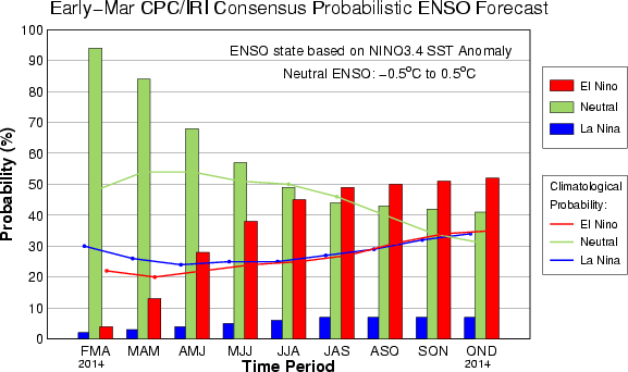
Looks like only a 50/50 shot of El Nino conditions by August/Sept/Oct:
http://iri.columbia.edu/wp-content/uplo ... igure1.gif
http://iri.columbia.edu/wp-content/uplo ... igure1.gif
0 likes
-
Kingarabian

- S2K Supporter

- Posts: 16364
- Joined: Sat Aug 08, 2009 3:06 am
- Location: Honolulu, Hawaii
Re:
hurricanetrack wrote:Looks like only a 50/50 shot of El Nino conditions by August/Sept/Oct:
http://iri.columbia.edu/wp-content/uplo ... igure1.gif
Don't worry about the models right now.
Look at the SOI, PDO, SST, and ESPI. Those tell a lot more than what the models say.
0 likes
RIP Kobe Bryant


Re: Re:
Kingarabian wrote:hurricanetrack wrote:Looks like only a 50/50 shot of El Nino conditions by August/Sept/Oct:
http://iri.columbia.edu/wp-content/uplo ... igure1.gif
Don't worry about the models right now.
Look at the SOI, PDO, SST, and ESPI. Those tell a lot more than what the models say.
You also have to look at it in a probability point of view and not direct numbers. 50% but there are 3 states to Enso, thus they are saying of the 3 the highest probably for that period is Nino. Odds have been slowly rising on them for the past few months.
0 likes
The above post and any post by Ntxw is NOT an official forecast and should not be used as such. It is just the opinion of the poster and may or may not be backed by sound meteorological data. It is NOT endorsed by any professional institution including Storm2k. For official information, please refer to NWS products.
Help support Storm2K!
-
cycloneye
- Admin
- Posts: 149464
- Age: 69
- Joined: Thu Oct 10, 2002 10:54 am
- Location: San Juan, Puerto Rico
Re: ENSO: CPC 3/6/14 March update=El Nino watch issued
The 30 day SOI continues to crash. The latest data is down to -5.6.
20140205,20140306,-5.6
http://www.bom.gov.au/climate/enso/soi.txt
20140205,20140306,-5.6
http://www.bom.gov.au/climate/enso/soi.txt
0 likes
Visit the Caribbean-Central America Weather Thread where you can find at first post web cams,radars
and observations from Caribbean basin members Click Here
and observations from Caribbean basin members Click Here
Re: ENSO: CPC 3/6/14 March update=El Nino watch issued
cycloneye wrote:Look how the blue cold waters are shrinking west of South America as the warm waters expand.
http://oi60.tinypic.com/2a0icrr.jpg
The PDO (reading is off the north Pacific) definitely has leaned to more +PDO look. Don't know how much but odds are the February reading will likely continue from the January reading, maybe not very positive but there nonetheless. It is very reminiscent as the warmth has spread more than just the NE Pacific but right down the west coast of North America to the tropics. From What I read does not include the southern hemisphere, but even here the cooling off Australia is spreading.

Typical +PDO configuration

0 likes
The above post and any post by Ntxw is NOT an official forecast and should not be used as such. It is just the opinion of the poster and may or may not be backed by sound meteorological data. It is NOT endorsed by any professional institution including Storm2k. For official information, please refer to NWS products.
Help support Storm2K!
Help support Storm2K!

Re: ENSO: CPC 3/6/14 March update=El Nino watch issued
Ntxw wrote:cycloneye wrote:Look how the blue cold waters are shrinking west of South America as the warm waters expand.
http://oi60.tinypic.com/2a0icrr.jpg
The PDO (reading is off the north Pacific) definitely has leaned to more +PDO look. Don't know how much but odds are the February reading will likely continue from the January reading, maybe not very positive but there nonetheless. It is very reminiscent as the warmth has spread more than just the NE Pacific but right down the west coast of North America to the tropics. From What I read does not include the southern hemisphere, but even here the cooling off Australia is spreading.
http://i60.tinypic.com/2rr9amw.gif
Typical +PDO configuration
http://i60.tinypic.com/14nixoi.png
Positive PDO is more favorable for El Nino. There can be strong Eastern Equatorial El Nino in negative PDO, like in 1972-1973.
http://www.cpc.ncep.noaa.gov/products/a ... ears.shtml
0 likes
Re: ENSO: CPC 3/6/14 March update=El Nino watch issued
Ptarmigan wrote:Positive PDO is more favorable for El Nino. There can be strong Eastern Equatorial El Nino in negative PDO, like in 1972-1973.
http://www.cpc.ncep.noaa.gov/products/a ... ears.shtml
1972 Nino was such an interesting case. It was a powerful El Nino sandwiched in between intense La Nina's. The whole early 70s was -PDO driven. 1972 didn't actually feature a strong +PDO, it was weak to modest at best because of the Nino. Amazing that we got such a strong Nino in a severe -PDO time.
0 likes
The above post and any post by Ntxw is NOT an official forecast and should not be used as such. It is just the opinion of the poster and may or may not be backed by sound meteorological data. It is NOT endorsed by any professional institution including Storm2k. For official information, please refer to NWS products.
Help support Storm2K!
Help support Storm2K!
-
dexterlabio
- Category 5
- Posts: 3507
- Joined: Sat Oct 24, 2009 11:50 pm
Re: ENSO: CPC 3/6/14 March update=El Nino watch issued
For those who have knowledge about ENSO, do you think there's a high chance of a stronger El Nino this year compared to that of 2009? I don't remember that year showing the same features of a budding Nino at this early, particularly the large subsurface warm pool that we're seeing.
0 likes
Personal Forecast Disclaimer:
The posts in this forum are NOT official forecast and should not be used as such. They are just the opinion of the poster and may or may not be backed by sound meteorological data. They are NOT endorsed by any professional institution or storm2k.org. For official information, please refer to the NHC and NWS products.
The posts in this forum are NOT official forecast and should not be used as such. They are just the opinion of the poster and may or may not be backed by sound meteorological data. They are NOT endorsed by any professional institution or storm2k.org. For official information, please refer to the NHC and NWS products.
Re: ENSO: CPC 3/6/14 March update=El Nino watch issued
dexterlabio wrote:For those who have knowledge about ENSO, do you think there's a high chance of a stronger El Nino this year compared to that of 2009? I don't remember that year showing the same features of a budding Nino at this early, particularly the large subsurface warm pool that we're seeing.
We will find out soon. The big Nino's (72, 82, 97, 57) all had very early starts. AMJ most of them began their first >0.5C+. Moderate El Nino's like 2009 and 1963 begins mid to late summer. Weaker El Nino's tends to start much later in the year into the fall. Once the current warm pool up wells at the end of this month and early next month we will get a good idea what it may have in store. For right now it has not up-welled so we do not know how it will effect the eastern basin. If we see ENSO regions start spiking 0.5-1C then it's a good sign a big one is coming in April and May. 97 started to rise in mid April after lots of (-)s in March and never looked back.
0 likes
The above post and any post by Ntxw is NOT an official forecast and should not be used as such. It is just the opinion of the poster and may or may not be backed by sound meteorological data. It is NOT endorsed by any professional institution including Storm2k. For official information, please refer to NWS products.
Help support Storm2K!
Help support Storm2K!
-
CaliforniaResident
- Tropical Storm

- Posts: 215
- Joined: Fri Feb 21, 2014 1:47 pm
-
cycloneye
- Admin
- Posts: 149464
- Age: 69
- Joined: Thu Oct 10, 2002 10:54 am
- Location: San Juan, Puerto Rico
Re:
CaliforniaResident wrote:When will we begin to see the direct affects?
It takes some time for the effects from El Nino to be seen. We are on the very early stage for one to form and is not known how strong nor what kind of event it may be (Modoki or Traditional) so until El Nino is officially declared is a waiting game.
0 likes
Visit the Caribbean-Central America Weather Thread where you can find at first post web cams,radars
and observations from Caribbean basin members Click Here
and observations from Caribbean basin members Click Here
-
cycloneye
- Admin
- Posts: 149464
- Age: 69
- Joined: Thu Oct 10, 2002 10:54 am
- Location: San Juan, Puerto Rico
Re: ENSO Updates
The latest updated loop until March 4 speaks for itself.

0 likes
Visit the Caribbean-Central America Weather Thread where you can find at first post web cams,radars
and observations from Caribbean basin members Click Here
and observations from Caribbean basin members Click Here
Still slowly morphing that horseshoe of warmth in the Eastern North Pacific, cooler western Pacific (weak +PDO) look. Recent warming of the eastern tropical Pacific and the remaining surface cold waters about to be pushed out. Is it getting the red carpet out for the sub-surface to come? Lots of questions wanting answers!

Compare it to the 2012 non Nino with a raging -PDO. Horseshoe of cold off NA.

Compare it to the 2012 non Nino with a raging -PDO. Horseshoe of cold off NA.
0 likes
The above post and any post by Ntxw is NOT an official forecast and should not be used as such. It is just the opinion of the poster and may or may not be backed by sound meteorological data. It is NOT endorsed by any professional institution including Storm2k. For official information, please refer to NWS products.
Help support Storm2K!
Help support Storm2K!
-
cycloneye
- Admin
- Posts: 149464
- Age: 69
- Joined: Thu Oct 10, 2002 10:54 am
- Location: San Juan, Puerto Rico
Re: ENSO: Large warm pool at sub-surface rising to surface
Ntxw,you were right as 30 day SOI reached -6.0.
20140206,20140307,-6.0
20140206,20140307,-6.0
0 likes
Visit the Caribbean-Central America Weather Thread where you can find at first post web cams,radars
and observations from Caribbean basin members Click Here
and observations from Caribbean basin members Click Here
-
cycloneye
- Admin
- Posts: 149464
- Age: 69
- Joined: Thu Oct 10, 2002 10:54 am
- Location: San Juan, Puerto Rico
Re: ENSO: Large warm pool at sub-surface expanding east / rising
This graphic of the sub-surface waters is good because it has the numbers of warm and cold waters. This will be a slow process as those warm waters rise to the surface.Let's see how warm it gets on the Nino areas in the next few weeks.

0 likes
Visit the Caribbean-Central America Weather Thread where you can find at first post web cams,radars
and observations from Caribbean basin members Click Here
and observations from Caribbean basin members Click Here
-
gatorcane

- S2K Supporter
- Posts: 23708
- Age: 48
- Joined: Sun Mar 13, 2005 3:54 pm
- Location: Boca Raton, FL
"El Nino" watch Article released a few days ago by NWS Miami:
http://www.cpc.ncep.noaa.gov/products/a ... sodisc.pdf
As Wxman57 pointed out a few pages back, El nino certainly does not mean a diminished threat of hurricane hits to the Caribbean and U.S...
http://www.cpc.ncep.noaa.gov/products/a ... sodisc.pdf
As Wxman57 pointed out a few pages back, El nino certainly does not mean a diminished threat of hurricane hits to the Caribbean and U.S...
0 likes
It's getting ready to up-well. This is classic signature El Nino imprint below the surface. Cold waters emerging deep in the far far west. Deep, large warm pool that continues to expand. The buoy data above shows mass of warmth getting ready to be shoved south (0.5C or greater). The greens and blues SST's have all but disappeared near and at the surface. Anything below 0C is about to become history as most of the tropical Pacific is at or greater than 0C except little pockets in the far east. Once it up-wells this thing is going to sustain itself for months. Thru at least June if not July.


Nino 4 is there, Nino 3 is rising. These two set trends for 3.4 as the name suggests. You could even argue 2006 and 2009 weren't as large a warm pool as this one in their peaks.
Nino 4 is there, Nino 3 is rising. These two set trends for 3.4 as the name suggests. You could even argue 2006 and 2009 weren't as large a warm pool as this one in their peaks.
Last edited by Ntxw on Sun Mar 09, 2014 4:47 pm, edited 1 time in total.
0 likes
The above post and any post by Ntxw is NOT an official forecast and should not be used as such. It is just the opinion of the poster and may or may not be backed by sound meteorological data. It is NOT endorsed by any professional institution including Storm2k. For official information, please refer to NWS products.
Help support Storm2K!
Help support Storm2K!
-
cycloneye
- Admin
- Posts: 149464
- Age: 69
- Joined: Thu Oct 10, 2002 10:54 am
- Location: San Juan, Puerto Rico
Re:
Ntxw wrote:It's getting ready to up-well. This is classic signature El Nino imprint below the surface. Cold waters emerging deep in the far far west. Deep, large warm pool that continues to expand. The buoy data above shows mass of warmth getting ready to be shoved south (0.5C or greater). The greens and blues SST's have all but disappeared near and at the surface. Anything below 0C is about to become history as most of the tropical Pacific is at or greater than 0C except little pockets in the far east. Once it up-wells this thing is going to sustain itself for months. Thru at least June if not July.
http://i60.tinypic.com/14smcg9.gif
http://i60.tinypic.com/16jljix.gif
Nino 4 is there, Nino 3 is rising. These two set trends for 3.4 as the name suggests.
And after that period,new wind bursts will seal the deal to reinforce.
0 likes
Visit the Caribbean-Central America Weather Thread where you can find at first post web cams,radars
and observations from Caribbean basin members Click Here
and observations from Caribbean basin members Click Here
Who is online
Users browsing this forum: No registered users and 130 guests