
Texas Spring-2014
Moderator: S2k Moderators
Forum rules

The posts in this forum are NOT official forecast and should not be used as such. They are just the opinion of the poster and may or may not be backed by sound meteorological data. They are NOT endorsed by any professional institution or STORM2K.
-
aggiecutter
- Category 5

- Posts: 1755
- Joined: Thu Oct 14, 2004 9:22 pm
- Location: Texarkana
-
weatherdude1108
- Category 5
- Posts: 4228
- Joined: Tue Dec 13, 2011 1:04 pm
- Location: Northwest Austin/Cedar Park, TX
This just in. Keep an eye out today. Rain is nice.
Severe Thunderstorm Watch
SEVERE THUNDERSTORM WATCH OUTLINE UPDATE FOR WS 134
NWS STORM PREDICTION CENTER NORMAN OK
1040 AM CDT FRI MAY 9 2014
SEVERE THUNDERSTORM WATCH 134 IS IN EFFECT UNTIL 700 PM CDT
FOR THE FOLLOWING LOCATIONS
TXC013-019-021-029-031-053-055-091-123-127-137-149-163-171-177-
187-209-255-259-265-271-285-287-299-323-325-385-453-463-491-493-
507-100000-
/O.NEW.KWNS.SV.A.0134.140509T1540Z-140510T0000Z/
TX
. TEXAS COUNTIES INCLUDED ARE
ATASCOSA BANDERA BASTROP
BEXAR BLANCO BURNET
CALDWELL COMAL DEWITT
DIMMIT EDWARDS FAYETTE
FRIO GILLESPIE GONZALES
GUADALUPE HAYS KARNES
KENDALL KERR KINNEY
LAVACA LEE LLANO
MAVERICK MEDINA REAL
TRAVIS UVALDE WILLIAMSON
WILSON ZAVALA
0 likes
The preceding post is NOT an official forecast, and should not be used as such. It is only the opinion of the poster and may or may not be backed by sound meteorological data. It is NOT endorsed by any professional institution including storm2k.org. For Official Information please refer to the NHC and NWS products.
-
gboudx

- S2K Supporter

- Posts: 4090
- Joined: Thu Sep 04, 2003 1:39 pm
- Location: Rockwall, Tx but from Harvey, La
From jeff:
Radar starting to light up as short wave lift and clearing skies erode mid level capping inversion.
SPC has just issued a new Severe Thunderstorm Watch for SC and C TX effective until 700pm (see watch outline below).
Radar shows a couple of well defined supercells, one WNW of San Antonio, and the other about to cross the Rio Grande south of Del Rio. Air mass over SC and SE TX is becoming increasingly unstable with surface heating with instability values pushing 2500-3000 J/kg. Recent radar trends north of Houston show scattered showers attempting to develop along some sort of possible boundary from overnight convection to the north. Storm motions have been really slow in in this region and flash flooding is ongoing around the Lufkin area currently due to high rainfall rates. Will need to keep a close eye on development along this boundary and potential for slow storm motions this afternoon.
Further southward shortwave induced convection over SW TX should continue to grow upscale into cluster/MCS as downstream air mass destabilizes. Not sure any of the models are handling this well especially given the amount of sun the area is seeing. Will need to watch things closely over the next few hours for possible inclusion of severe weather risks across all of SE TX this afternoon and evening. I am very tempted to go with higher rain chances this afternoon based on radar trends, but we have been burned so many times recently…
0 likes
-
horselattitudesfarm

- Category 1

- Posts: 315
- Joined: Thu Jul 16, 2009 5:55 pm
- Location: Asheville, NC (formerly from Dallas, TX)
Re: Re:
ravyrn wrote:Texas Snowman wrote:5.52 inches today in Greenville. Wow!
We had about 1-inch here in Denison.
Did any of that heavy rainfall fall into Lavon's basin? I'm unfamiliar with the drainage basins, but if that much rain fell, I sure hope some of it makes its way to Lavon. If anyone more savvy with the hydrological data than myself would share a link you have on hand for water-level changes in Lavon or other lakes from today's rainfall it'd be much appreciated.
The one I use is:
http://www.lakelevels.info/?StateID=TX
0 likes
-
TeamPlayersBlue

- Category 5
- Posts: 3531
- Joined: Tue Feb 02, 2010 1:44 am
- Location: Denver/Applewood, CO
Those storms that just popped up SE of SA are going to bring some serious rainfall amounts. Barely moving.
0 likes
Personal Forecast Disclaimer:
The posts in this forum are NOT official forecast and should not be used as such. They are just the opinion of the poster and may or may not be backed by sound meteorological data. They are NOT endorsed by any professional institution or storm2k.org. For official information, please refer to the NHC and NWS products.
The posts in this forum are NOT official forecast and should not be used as such. They are just the opinion of the poster and may or may not be backed by sound meteorological data. They are NOT endorsed by any professional institution or storm2k.org. For official information, please refer to the NHC and NWS products.
-
Portastorm

- Storm2k Moderator

- Posts: 9955
- Age: 63
- Joined: Fri Jul 11, 2003 9:16 am
- Location: Round Rock, TX
- Contact:
Re: Texas Spring-2014
This is just comical now. Radar lit up at 2 p.m. Storms to our southwest moving south of the metro area. Heavy convection developing in a line stretching northeast to southwest to our EAST. And there's convection to our south moving EAST.
Another day, another watch, another big fat frickin' zero in the rain gauge.
For those of you thinking "geez will this guy stop whining?" I'm done. Don't worry. If it ever rains again of consequence in Austin, I'll post.
Another day, another watch, another big fat frickin' zero in the rain gauge.
For those of you thinking "geez will this guy stop whining?" I'm done. Don't worry. If it ever rains again of consequence in Austin, I'll post.
0 likes
Any forecasts under my name are to be taken with a grain of salt. Get your best forecasts from the National Weather Service and National Hurricane Center.
-
Texas Snowman

- Storm2k Moderator
- Posts: 6197
- Joined: Fri Jan 25, 2008 11:29 am
- Location: Denison, Texas
I feel your pain Porta.
But I think I can tell you with some certainty when it will rain in Austin.
And that would be tomorrow.
Why? Because we're moving my daughter out of her dorm for the summer at UT.
Pretty sure that will bring a gully washer to the Capitol City.

But I think I can tell you with some certainty when it will rain in Austin.
And that would be tomorrow.
Why? Because we're moving my daughter out of her dorm for the summer at UT.
Pretty sure that will bring a gully washer to the Capitol City.
0 likes
The above post and any post by Texas Snowman is NOT an official forecast and should not be used as such. It is just the opinion of the poster and may or may not be backed by sound meteorological data. It is NOT endorsed by any professional institution including storm2k.org. For official information, please refer to NWS products.
-
vbhoutex

- Storm2k Executive

- Posts: 29149
- Age: 74
- Joined: Wed Oct 09, 2002 11:31 pm
- Location: Cypress, TX
- Contact:
Re: Texas Spring-2014
Portastorm wrote:This is just comical now. Radar lit up at 2 p.m. Storms to our southwest moving south of the metro area. Heavy convection developing in a line stretching northeast to southwest to our EAST. And there's convection to our south moving EAST.
Another day, another watch, another big fat frickin' zero in the rain gauge.
For those of you thinking "geez will this guy stop whining?" I'm done. Don't worry. If it ever rains again of consequence in Austin, I'll post.
I feel your pain to Porta. We have had .04" of rain so far this month. That is also the amount we have had in the last 30 days. We are almost 7" below normal so far this year.
0 likes
Skywarn, C.E.R.T.
Please click below to donate to STORM2K to help with the expenses of keeping the site going:

Please click below to donate to STORM2K to help with the expenses of keeping the site going:
-
wxman57

- Moderator-Pro Met

- Posts: 23175
- Age: 68
- Joined: Sat Jun 21, 2003 8:06 pm
- Location: Houston, TX (southwest)
Re: Texas Spring-2014
Nah, it's looking dry for this weekend. 12z GFS indicates some near record cold weather in Houston next week, along with a few inches of rain.
By the way, Portastorm, the National Hurricane Conference will be in Austin next spring. We'll have to get together for lunch or something. That's assuming I'll be attending. Good chance of that since I can drive there.

Even colder there in Austin next week. Some significant rain as well. Interesting that the GFS has Austin getting a lot more rain than Houston with the current weather system.

By the way, Portastorm, the National Hurricane Conference will be in Austin next spring. We'll have to get together for lunch or something. That's assuming I'll be attending. Good chance of that since I can drive there.
Even colder there in Austin next week. Some significant rain as well. Interesting that the GFS has Austin getting a lot more rain than Houston with the current weather system.
0 likes
-
vbhoutex
- Storm2k Executive
- Posts: 29149
- Age: 74
- Joined: Wed Oct 09, 2002 11:31 pm
- Location: Cypress, TX
- Contact:
Re: Texas Spring-2014

0 likes
Skywarn, C.E.R.T.
Please click below to donate to STORM2K to help with the expenses of keeping the site going:
Please click below to donate to STORM2K to help with the expenses of keeping the site going:
-
TeamPlayersBlue
- Category 5
- Posts: 3531
- Joined: Tue Feb 02, 2010 1:44 am
- Location: Denver/Applewood, CO
Saw JB tweet last night, looks big. (Cold)
0 likes
Personal Forecast Disclaimer:
The posts in this forum are NOT official forecast and should not be used as such. They are just the opinion of the poster and may or may not be backed by sound meteorological data. They are NOT endorsed by any professional institution or storm2k.org. For official information, please refer to the NHC and NWS products.
The posts in this forum are NOT official forecast and should not be used as such. They are just the opinion of the poster and may or may not be backed by sound meteorological data. They are NOT endorsed by any professional institution or storm2k.org. For official information, please refer to the NHC and NWS products.


-
aggiecutter
- Category 5
- Posts: 1755
- Joined: Thu Oct 14, 2004 9:22 pm
- Location: Texarkana


Re: Texas Spring-2014
Portastorm wrote:This is just comical now. Radar lit up at 2 p.m. Storms to our southwest moving south of the metro area. Heavy convection developing in a line stretching northeast to southwest to our EAST. And there's convection to our south moving EAST.
Another day, another watch, another big fat frickin' zero in the rain gauge.
For those of you thinking "geez will this guy stop whining?" I'm done. Don't worry. If it ever rains again of consequence in Austin, I'll post.
Man, I hate it for you. I know exactly how you feel, it happens to me at least 70% of the time. I'm still in disbelief we got all the rain we did yesterday. I've seen water standing in places I haven't seen it do in a loooooooong time.
0 likes
The above post and any post by dhweather is NOT an official forecast and should not be used as such. It is just the opinion of the poster and may or may not be backed by sound meteorological data. It is NOT endorsed by any professional institution including storm2k.org. For official information, please refer to NWS products.
-
aggiecutter
- Category 5
- Posts: 1755
- Joined: Thu Oct 14, 2004 9:22 pm
- Location: Texarkana

Re: Texas Spring-2014
*MAYBE* this will happen so that the PWC gets some appreciable rain. Run Total Precip from the 12Z Euro:


0 likes
The above post and any post by dhweather is NOT an official forecast and should not be used as such. It is just the opinion of the poster and may or may not be backed by sound meteorological data. It is NOT endorsed by any professional institution including storm2k.org. For official information, please refer to NWS products.
-
Rgv20

- S2K Supporter
- Posts: 2466
- Age: 39
- Joined: Wed Jan 05, 2011 5:42 pm
- Location: Edinburg/McAllen Tx
Severe Thunderstorm Watch for Deep South Texas!
Severe Thunderstorm Watch
SEVERE THUNDERSTORM WATCH OUTLINE UPDATE FOR WS 136
NWS STORM PREDICTION CENTER NORMAN OK
500 PM CDT FRI MAY 9 2014
SEVERE THUNDERSTORM WATCH 136 IS IN EFFECT UNTIL 1100 PM CDT
FOR THE FOLLOWING LOCATIONS
TXC047-061-131-215-247-249-261-273-355-427-479-489-505-100400-
/O.NEW.KWNS.SV.A.0136.140509T2200Z-140510T0400Z/
TX
. TEXAS COUNTIES INCLUDED ARE
BROOKS CAMERON DUVAL
HIDALGO JIM HOGG JIM WELLS
KENEDY KLEBERG NUECES
STARR WEBB WILLACY
ZAPATA
$$
0 likes
The following post is NOT an official forecast and should not be used as such. It is just the opinion of the poster and may or may not be backed by sound meteorological data. It is NOT endorsed by any professional institution including storm2k.org For Official Information please refer to the NHC and NWS products.
-
Rgv20
- S2K Supporter
- Posts: 2466
- Age: 39
- Joined: Wed Jan 05, 2011 5:42 pm
- Location: Edinburg/McAllen Tx
AREA FORECAST DISCUSSION...UPDATED
NATIONAL WEATHER SERVICE BROWNSVILLE TX
558 PM CDT FRI MAY 9 2014
.DISCUSSION...SURFACE PRESSURE FALLS OVER MEXICO IN RESPONSE TO
THE ADVANCING UPPER LEVEL WAVE CONTINUE TO PRODUCE A MORE EASTERLY
COMPONENT TO THE SURFACE WINDS OVER THE NORTHERN TIER OF COUNTIES.
RESIDUAL OUTFLOW BOUNDARIES MAY WORK WITH EFFECTIVE HELICITY
VALUES AROUND 100 M2/S2 TO PRODUCE A BRIEF ISOLATED TORNADO THREAT
THROUGH THE NEXT 3 HOURS OR SO MAINLY IN BROOKS/JIM HOGG/KENEDY
AND ZAPATA COUNTIES. LOCAL INCREASES IN HELICITY IN ZAPATA COUNTY
AT THE BEND OF A CONVECTIVE STRUCTURE TAKING AN INCREASINGLY LINE
ECHO WAVE PATTERN SHAPE MAY ALSO BRIEFLY LOCALLY INCREASE SEVERE
THREAT. EFFECTIVE DEEP LAYER SHEAR VALUES OF 50 TO 60 KNOTS AND
MIXED LAYER CAPES AT 2000 TO 2500 J/KG CONTINUES TO PRODUCE SEVERE
WEATHER THREAT ACROSS THE ENTIRE CWA MOVING FROM WEST TO EAST AS THE
EVENING PROGRESSESE. RADAR Z/V DATA AND RECENT TRENDS WILL REQUIRE
THE ISSUANCE OF SEVERE THUNDERSTORM WARNINGS STARTING VERY SHORTLY
OVER OUR NORTHWESTERN ZONES PRIMARILY FOR DAMAGING WIND WITH THE
ATTENDANT THREAT OF LARGE HAIL IN THE STRONGEST CORES.
WITH PRECIPITABLE WATER VALUES AT 1.8 TO 2.0 INCHES...AMONGST
HISTORICAL HIGH VALUES FOR THIS TIME OF YEAR WILL ALSO BE CLOSELY
MONTIORING THE HYDROLOGICAL RESPONSE AND FLASH FLOOD WARNINGS MAY
BE REQUIRED AS THE EVENING PROGRESSES GIVEN THE LARGE AREAL
COVERAGE AND SLOW MOVEMENT OF STORMS.
0 likes
The following post is NOT an official forecast and should not be used as such. It is just the opinion of the poster and may or may not be backed by sound meteorological data. It is NOT endorsed by any professional institution including storm2k.org For Official Information please refer to the NHC and NWS products.
-
Rgv20
- S2K Supporter
- Posts: 2466
- Age: 39
- Joined: Wed Jan 05, 2011 5:42 pm
- Location: Edinburg/McAllen Tx
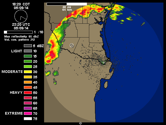
Line of Storm look nasty! I can already hear the thunder outside..

0 likes
The following post is NOT an official forecast and should not be used as such. It is just the opinion of the poster and may or may not be backed by sound meteorological data. It is NOT endorsed by any professional institution including storm2k.org For Official Information please refer to the NHC and NWS products.

Things are boding well for the long term. After the chill next week (for May) overall it looks like another trough will again park to our west. Moist flow incoming from the Pacific, maybe even far west Texas will be into play. As long as these troughs continue to plow west of us we're in good standings. Our old enemy the Pacific Ocean in the summer is now becoming an asset. Monsoonal trough around the gulf of Tehuantepec right below us is quite active as Nino 3, 1+2, and 3.4 are warm aiding rich moisture from this region..
http://www.ssd.noaa.gov/goes/east/epac/flash-wv.html
http://www.ssd.noaa.gov/goes/east/epac/flash-wv.html
0 likes
The above post and any post by Ntxw is NOT an official forecast and should not be used as such. It is just the opinion of the poster and may or may not be backed by sound meteorological data. It is NOT endorsed by any professional institution including Storm2k. For official information, please refer to NWS products.
Help support Storm2K!
Return to “USA & Caribbean Weather”
Who is online
Users browsing this forum: txtwister78 and 167 guests