ENSO Updates (2007 thru 2023)
Moderator: S2k Moderators
Forum rules

The posts in this forum are NOT official forecasts and should not be used as such. They are just the opinion of the poster and may or may not be backed by sound meteorological data. They are NOT endorsed by any professional institution or STORM2K. For official information, please refer to products from the National Hurricane Center and National Weather Service.
-
dexterlabio
- Category 5

- Posts: 3506
- Joined: Sat Oct 24, 2009 11:50 pm
The safest bet of when El Nino will be declared is in June, IMO. We need another strong round of MJO/Kelvin wave to kick start 3.4 warming.
0 likes
Personal Forecast Disclaimer:
The posts in this forum are NOT official forecast and should not be used as such. They are just the opinion of the poster and may or may not be backed by sound meteorological data. They are NOT endorsed by any professional institution or storm2k.org. For official information, please refer to the NHC and NWS products.
The posts in this forum are NOT official forecast and should not be used as such. They are just the opinion of the poster and may or may not be backed by sound meteorological data. They are NOT endorsed by any professional institution or storm2k.org. For official information, please refer to the NHC and NWS products.
-
euro6208
Re: IRI % for ASO at 67% / CPC 5/19/14=Nino 3.4 down to +0.4C
There goes the required +0.5C that needs to be maintained for the declaration of an el nino and comparison to 1997. More like this will just delay the arrival and possibly strong status for this el nino... 
0 likes
-
xtyphooncyclonex

- Category 5
- Posts: 3891
- Age: 24
- Joined: Sat Dec 08, 2012 9:07 am
- Location: Cebu City
- Contact:
Re: IRI % for ASO at 67% / CPC 5/19/14=Nino 3.4 down to +0.4C
euro6208 wrote:There goes the required +0.5C that needs to be maintained for the declaration of an el nino and comparison to 1997. More like this will just delay the arrival and possibly strong status for this el nino...
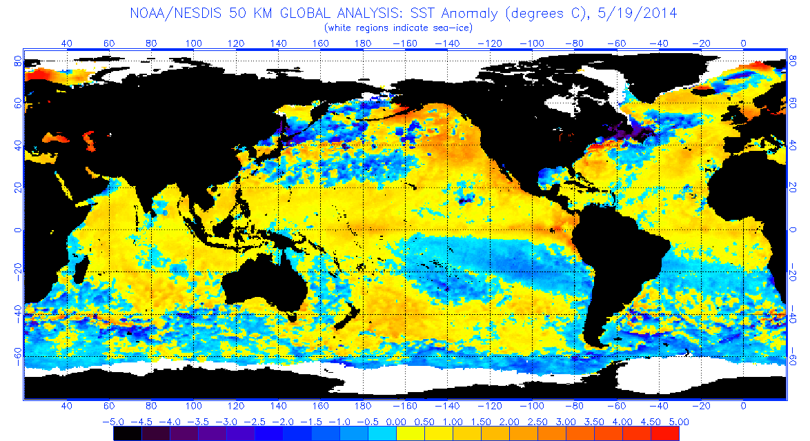
This just doesn't make sense. The buoys show a wide swath of +1ºC anomalies over the region. This could likely be a miscalculation. Looking at the NOAA/NESDIS 50KM SST Anomalies, overall equatorial Pacific warming was observed. They handled the situation wrongly, as instead of noticing the warmth and the surfacing of some +1ºC anomalies as they are supposed to obviously increase the reading to like +0.6ºC.
What else does not make sense is that the IRI lowered the probability of an El Niño to barely 70% by its peak. Instead of 55-60% el niño to 41% neutral to just 50-50% for MJJ. Warming is at a faster rate than expected.
Last edited by xtyphooncyclonex on Mon May 19, 2014 10:38 am, edited 2 times in total.
0 likes
REMINDER: My opinions that I, or any other NON Pro-Met in this forum, are unofficial. Please do not take my opinions as an official forecast and warning. I am NOT a meteorologist. Following my forecasts blindly may lead to false alarm, danger and risk if official forecasts from agencies are ignored.
-
Yellow Evan

- Professional-Met

- Posts: 16240
- Age: 27
- Joined: Fri Jul 15, 2011 12:48 pm
- Location: Henderson, Nevada/Honolulu, HI
- Contact:
-
xtyphooncyclonex
- Category 5
- Posts: 3891
- Age: 24
- Joined: Sat Dec 08, 2012 9:07 am
- Location: Cebu City
- Contact:
Re:
Yellow Evan wrote:Any incite to why they lowered it to .4C? It makes no sense to me.
Their downgrade of the index this update deserves some sentiments. I have absolutely no idea why. The negative anomalies are moving south and are shrinking. The overall surface there HAS WARMED. Let us just wait for the BOM and hope they will not do the same by tomorrow (later in your time).
0 likes
REMINDER: My opinions that I, or any other NON Pro-Met in this forum, are unofficial. Please do not take my opinions as an official forecast and warning. I am NOT a meteorologist. Following my forecasts blindly may lead to false alarm, danger and risk if official forecasts from agencies are ignored.
-
euro6208
Re:
Yellow Evan wrote:Any incite to why they lowered it to .4C? It makes no sense to me.
Maybe just a blip as warming is faster than what data can allow. Think of a rapidly intensifying cyclone and dvorak just plain catching up. Just wait for the cyclone to slow it's intensification phrase then data will catch up.
0 likes
-
xtyphooncyclonex
- Category 5
- Posts: 3891
- Age: 24
- Joined: Sat Dec 08, 2012 9:07 am
- Location: Cebu City
- Contact:
Re: Re:
euro6208 wrote:Yellow Evan wrote:Any incite to why they lowered it to .4C? It makes no sense to me.
Maybe just a blip as warming is faster than what data can allow. Think of a rapidly intensifying cyclone and dvorak just plain catching up. Just wait for the cyclone to slow it's intensification phrase then data will catch up.
Somewhat unrelated, but like what happened during typhoon Haiyan? Dvorak was just barely catching up then went up rapidly. Like a typical super el Niño, rapidly intensifying then CPC takes time to issue the right reading for the SST anomaly.
1997:
May 7: +0.8ºC
May 14: +0.6ºC
Now:
May 7: +0.5ºC
May 14: +0.4ºC
0 likes
REMINDER: My opinions that I, or any other NON Pro-Met in this forum, are unofficial. Please do not take my opinions as an official forecast and warning. I am NOT a meteorologist. Following my forecasts blindly may lead to false alarm, danger and risk if official forecasts from agencies are ignored.
Re: IRI % for ASO at 67% / CPC 5/19/14=Nino 3.4 down to +0.4C
xtyphooncyclonex wrote:euro6208 wrote:There goes the required +0.5C that needs to be maintained for the declaration of an el nino and comparison to 1997. More like this will just delay the arrival and possibly strong status for this el nino...
This just doesn't make sense. The buoys show a wide swath of +1ºC anomalies over the region. This could likely be a miscalculation. Looking at the NOAA/NESDIS 50KM SST Anomalies, overall equatorial Pacific warming was observed. They handled the situation wrongly, as instead of noticing the warmth and the surfacing of some +1ºC anomalies as they are supposed to obviously increase the reading to like +0.6ºC.
What else does not make sense is that the IRI lowered the probability of an El Niño to barely 70% by its peak. Instead of 55-60% el niño to 41% neutral to just 50-50% for MJJ. Warming is at a faster rate than expected.
the warm waters are no there yet. Be patient
0 likes
-
HURRICANELONNY
- Category 5
- Posts: 1392
- Joined: Wed May 07, 2003 6:48 am
- Location: HOLLYWOOD.FL
Re: IRI % for ASO at 67% / CPC 5/19/14=Nino 3.4 down to +0.4C
Either I'mn color blind or these sst stats are wrong but it looks like .5 and above to me for the whole equator.
http://www.ospo.noaa.gov/data/sst/anoma ... 9.2014.gif
http://www.ospo.noaa.gov/data/sst/anoma ... 9.2014.gif
0 likes
hurricanelonny
-
JonathanBelles
- Professional-Met
- Posts: 11430
- Age: 35
- Joined: Sat Dec 24, 2005 9:00 pm
- Location: School: Florida State University (Tallahassee, FL) Home: St. Petersburg, Florida
- Contact:
Please read the package put together by the CPC before beating them up!
http://www.cpc.ncep.noaa.gov/products/a ... ts-web.pdf
Remember, SST's are not the only factor...
http://www.cpc.ncep.noaa.gov/products/a ... ts-web.pdf
Remember, SST's are not the only factor...
0 likes

Re: ENSO Updates
xtyphooncyclonex wrote:NDG wrote:xtyphooncyclonex wrote:SOI and SST anomalies have no correlation at all. We had a higher SOI during the 2009 el Niño.
You can't say that, 2009 El nino remained weak during the late summer until the SOI really started tanking into negative values in fall of 2009, so IMO there is a correlation.
2004 was the weakest on record and had nearly the same 30 day SOI as 1997 at below -25.
I don't see the 30 day SOI any where close to below -25 in any month during 2004 as it did in 1997, do you have a link to show me otherwise?
http://www.bom.gov.au/climate/current/soihtm1.shtml
My point is, that not unless we start seeing those kind of numbers with the SOI you can forget about a moderate to strong El Nino developing any time soon as it did in 1997, and that is where the correlation comes in.
0 likes

Lol
Cyclenall wrote: Well I for one is disappointed, just another disappointment in a long list of them so far in 2014.
*Cut*
That was unique and riveting on some level, now even that is back-pedaling a bit
I stand by this post a week ago after today's CPC update showing Nino 3.4 down by 0.1ºC.
euro6208 wrote:Maybe just a blip as warming is faster than what data can allow. Think of a rapidly intensifying cyclone and dvorak just plain catching up. Just wait for the cyclone to slow it's intensification phrase then data will catch up.
That makes no sense, if that was the case then 3.4 region would stay the same at worst. For all the tropical cyclones that I observed rapidly intensifying, I have never seen the numbers go down at all but slowly up and then catches up to the real strength like logic would dictate.
0 likes
-
xtyphooncyclonex
- Category 5
- Posts: 3891
- Age: 24
- Joined: Sat Dec 08, 2012 9:07 am
- Location: Cebu City
- Contact:
Now let's wait for the BOM's update.
0 likes
REMINDER: My opinions that I, or any other NON Pro-Met in this forum, are unofficial. Please do not take my opinions as an official forecast and warning. I am NOT a meteorologist. Following my forecasts blindly may lead to false alarm, danger and risk if official forecasts from agencies are ignored.
-
Kingarabian

- S2K Supporter

- Posts: 16364
- Joined: Sat Aug 08, 2009 3:06 am
- Location: Honolulu, Hawaii
SOI is UP because we've had no shift in winds. Been a while since we had any sort of WWB.
Last edited by Kingarabian on Mon May 19, 2014 6:14 pm, edited 1 time in total.
0 likes
RIP Kobe Bryant
-
cycloneye

- Admin

- Posts: 149455
- Age: 69
- Joined: Thu Oct 10, 2002 10:54 am
- Location: San Juan, Puerto Rico
Re:
Kingarabian wrote:SOI is down because we've had no shift in winds. Been a while since we had any sort of WWB.
You meant SOI is up in positive for more than 2 weeks?
0 likes
Visit the Caribbean-Central America Weather Thread where you can find at first post web cams,radars
and observations from Caribbean basin members Click Here
and observations from Caribbean basin members Click Here


-
Yellow Evan
- Professional-Met
- Posts: 16240
- Age: 27
- Joined: Fri Jul 15, 2011 12:48 pm
- Location: Henderson, Nevada/Honolulu, HI
- Contact:
Re:
NDG wrote:If you ask me if the latest CFSv2 is correct and its trends continuous, similarities to a weak Modoki El Nino is not out of the question during the heart of the Atlantic Hurricane season, IMO.
That doesn't look like a Modoki to me. Notice how the 3.4 forecast is higher than the 4 forecast. That looks like a moderate El Nino.
0 likes


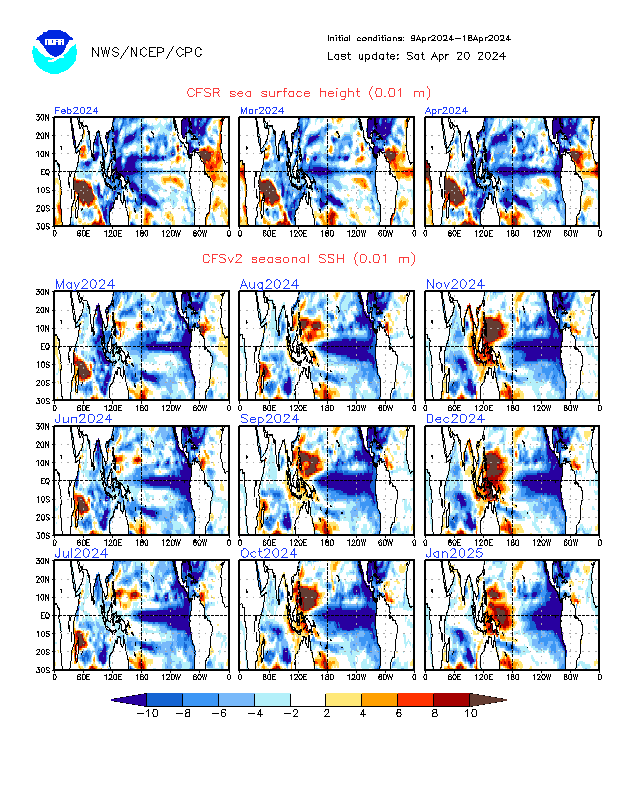
Sea surface heights do not resemble at all a modoki. There is a very distinct look when one occurs that the far WPAC and the western regions sees significant sea rises but never to the east, even in 2009 (it was actually a basin-wide Nino just strongest at 3.4) when it was pretty strong for a modoki there was lower SSH near SA.


SSH is not SSTA but there is a very strong correlation where there is rises in SSH is where the most warming occurs down the road.
SSH is not SSTA but there is a very strong correlation where there is rises in SSH is where the most warming occurs down the road.
0 likes
The above post and any post by Ntxw is NOT an official forecast and should not be used as such. It is just the opinion of the poster and may or may not be backed by sound meteorological data. It is NOT endorsed by any professional institution including Storm2k. For official information, please refer to NWS products.
Help support Storm2K!
Re: IRI % for ASO at 67% / CPC 5/19/14=Nino 3.4 down to +0.4C
One more image to add, CFSv2 SSH forecast:
0 likes
Re: IRI % for ASO at 67% / CPC 5/19/14=Nino 3.4 down to +0.4C
NDG wrote::uarrow: The forecast may be that close to a Modoki but it surely does not look like the typical eastern based El Nino like in '97.
It's got a long way to go if it's going to duplicate this, a cold pool would need to develop underneath in the east. 2004 never saw SSH rises much above near SA in a true modoki at any point in it's life. It remained at or below from January through Sept.

Last edited by Ntxw on Mon May 19, 2014 7:10 pm, edited 1 time in total.
0 likes
The above post and any post by Ntxw is NOT an official forecast and should not be used as such. It is just the opinion of the poster and may or may not be backed by sound meteorological data. It is NOT endorsed by any professional institution including Storm2k. For official information, please refer to NWS products.
Help support Storm2K!
Help support Storm2K!
Who is online
Users browsing this forum: Google [Bot], pepecool20 and 186 guests