Texas Spring-2014
Moderator: S2k Moderators
Forum rules

The posts in this forum are NOT official forecast and should not be used as such. They are just the opinion of the poster and may or may not be backed by sound meteorological data. They are NOT endorsed by any professional institution or STORM2K.
-
TeamPlayersBlue

- Category 5

- Posts: 3530
- Joined: Tue Feb 02, 2010 1:44 am
- Location: Denver/Applewood, CO
5.92 inches for my storm total in Sugar Land. Last night was some of the hardest rain ive seen in a while for such a long period of time. 3.33 inches in last nights deluge alone. I'll take it.
0 likes
Personal Forecast Disclaimer:
The posts in this forum are NOT official forecast and should not be used as such. They are just the opinion of the poster and may or may not be backed by sound meteorological data. They are NOT endorsed by any professional institution or storm2k.org. For official information, please refer to the NHC and NWS products.
The posts in this forum are NOT official forecast and should not be used as such. They are just the opinion of the poster and may or may not be backed by sound meteorological data. They are NOT endorsed by any professional institution or storm2k.org. For official information, please refer to the NHC and NWS products.
-
Lagreeneyes03
- Category 2

- Posts: 610
- Joined: Mon Dec 09, 2013 10:53 am
- Location: Luxurious Lake Grapevine
Re: Texas Spring-2014
What are the realistic chances for measurable rainfall for the DFW area for the rest of the week? Warming nicely right now, will that cause some strong storms later today?
0 likes
I'm a Princess, not a forecaster.

Re: Re:
weatherdude1108 wrote:dhweather wrote:ndale wrote:We got another 2 inches of rain since last night, makes the 2 day total to over 4.25 inches.
Woohoo! Good for you guys!
We got dry slotted. Storm total at my house 0.15

I feel for you dhweather. That has been our luck the past several events, with the exception of this last one, and maybe the one a couple weeks ago. Sorry about that.Maybe the low pressure will retrograde back towards the west to even out the distribution(?). Here's hoping!
Eastplexers got drenched earlier in the month while everyone else got the short end of the stick. Powers that be evened things out letting the western areas benefit this time. For the whole month Texas is doing quite well, I will post rainfall maps later this evening.
0 likes
The above post and any post by Ntxw is NOT an official forecast and should not be used as such. It is just the opinion of the poster and may or may not be backed by sound meteorological data. It is NOT endorsed by any professional institution including Storm2k. For official information, please refer to NWS products.
Help support Storm2K!
Here is the 30 day rainfall (most of May) totals

0 likes
The above post and any post by Ntxw is NOT an official forecast and should not be used as such. It is just the opinion of the poster and may or may not be backed by sound meteorological data. It is NOT endorsed by any professional institution including Storm2k. For official information, please refer to NWS products.
Help support Storm2K!
Help support Storm2K!
-
CYCLONE MIKE
- Category 5
- Posts: 2183
- Joined: Tue Aug 31, 2004 6:04 pm
- Location: Gonzales, LA
Re: Texas Spring-2014
That light purple blob in se LA is right over where I live. Almost all of that occurred from midnight last night to noon today. The usgs gauge in Gonzales received just under 13 inches so radar estimates are pretty close.
0 likes

Re: Texas Spring-2014
Porta, I was able to dismantle the Omega Block about a month earlier than expected per my sig. You're welcome, ATX!
0 likes
-
weatherdude1108
- Category 5
- Posts: 4228
- Joined: Tue Dec 13, 2011 1:04 pm
- Location: Northwest Austin/Cedar Park, TX
Encouraging video blog by Bob Rose on the El Niño. Just trying to think of the prize to get through this Summer. 
Bob Rose
http://www.lcra.org/water/river-and-wea ... ather.aspx
EWX discussion
"000
FXUS64 KEWX 290850
AFDEWX
AREA FORECAST DISCUSSION
NATIONAL WEATHER SERVICE AUSTIN/SAN ANTONIO TX
350 AM CDT THU MAY 29 2014
.SHORT TERM (TODAY THROUGH FRIDAY)...
THE UPPER LOW THAT HAS BROUGHT BENEFICIAL RAINS TO THE AREA OVER
MEMORIAL DAY WEEKEND HAS BUCKED THE SOUTHWARD MOTION TRENDS
DEPICTED IN YESTERDAYS MODEL RUNS AND SHIFTED NORTHEAST INTO SRN
ARKANSAS. DESPITE THE SIGNIFICANT DIFFERENCE IN THE CENTER
POSITION OVER A 24-HR FORECAST PERIOD...THE IMPACTS ARE EXPECTED
TO BE SUBTLE AS WHEN MODELS DEPICT A WWD SHIFT BACK TOWARD CENTRAL
TX AS THE LOW WEAKENS INTO A SHEAR AXIS. THE SHIFT BACK THE W/SW
IS EXPECTED FROM A BUILDING SHORTWAVE RIDGE OVER THE NORTHERN
PLAINS...SO WILL CONTINUE TO BUY INTO THE MODEL CONSENSUS ON SOME
ISOLATED RAIN CHANCES SPREADING BACK WWD INTO EASTERN COUNTIES
TODAY THROUGH FRIDAY. AS FOR THE SUBTLE CHANGES FROM YESTERDAYS
FORECAST...POP TRENDS ARE DOWN FOR FRIDAY AND TEMPERATURE TRENDS
ARE UP SLIGHTLY.
&&
.LONG TERM (FRIDAY NIGHT THROUGH WEDNESDAY)...
THE SLIGHTLY WARMER AND DRIER TREND IS CONTINUED INTO SATURDAY AS
MODEL CONSENSUS SHOULD A SHARP UPPER RIDGE DEVELOPING OVER W
TX...ADDING SUBSIDENCE TO OFFSET PRECIPITABLE WATER VALUES STILL
EXPECTED TO PEAK IN THE 1.8 TO 1.95 RANGE OVER EASTERN COUNTIES.
IN GOING WITH THE TRENDS...QPF VALUES FOR FRIDAY INTO SATURDAY
ARE NOT MUCH TO GET EXCITED ABOUT...WITH ONLY A FEW AREAS EXPECTED
TO SEE RAINFALL AMOUNTS OVER 1/4 INCH. THE UPPER RIDGE CONTINUES
TO NOSE EASTWARD INTO TX SUNDAY THROUGH MUCH OF NEXT WEEK WITH A
FLAT ZONAL FLOW NOT FAR TO THE NORTH. THIS VACATES MUCH OF THE
MOISTURE SENT NORTHWARD INTO THE WRN US FROM FORMER HURRICANE
AMANDA. HOT AND HUMID CONDITIONS ARE EXPECTED TO DEVELOP BY MONDAY
AND CONTINUE TO DEPLETE THE RECENTLY ACQUIRED SOIL MOISTURE
THROUGH MUCH OF NEXT WEEK. AS FOR THE NEXT EXPECTED PATTERN
CHANGE...THE GFS AND ECMWF HAVE BEEN ADVERTISING A LOW AMPLITUDE
TROUGH TO MODERATE TEMPERATURES AND POSSIBLY GENERATE RAIN CHANCES
OVER TX NEXT WEEKEND."
0 likes
The preceding post is NOT an official forecast, and should not be used as such. It is only the opinion of the poster and may or may not be backed by sound meteorological data. It is NOT endorsed by any professional institution including storm2k.org. For Official Information please refer to the NHC and NWS products.
Re: Texas Spring-2014
The models right now are struggling down on the coasts of MX. Amanda is no longer a named system. GFS has been showing Carib/BOC activity while the Euro favors more development over in the EPAC albeit GFS has been going west and weakening each run. Regardless higher moisture flow may eventually make it back again especially if the EPAC scenario wins out from the monsoonal gyre. June may come in with more fireworks.
Models have been struggling with the tropics and especially Pacific, constantly trying to show heat ridges that don't materialize or is of weaker/transient status in the long range.
Models have been struggling with the tropics and especially Pacific, constantly trying to show heat ridges that don't materialize or is of weaker/transient status in the long range.
0 likes
The above post and any post by Ntxw is NOT an official forecast and should not be used as such. It is just the opinion of the poster and may or may not be backed by sound meteorological data. It is NOT endorsed by any professional institution including Storm2k. For official information, please refer to NWS products.
Help support Storm2K!
Help support Storm2K!


-
TeamPlayersBlue
- Category 5
- Posts: 3530
- Joined: Tue Feb 02, 2010 1:44 am
- Location: Denver/Applewood, CO
Re: Texas Spring-2014
wxman57 wrote:Closing in on 10" for May's precip.
Now all i can think of is mosquitos :|
0 likes
Personal Forecast Disclaimer:
The posts in this forum are NOT official forecast and should not be used as such. They are just the opinion of the poster and may or may not be backed by sound meteorological data. They are NOT endorsed by any professional institution or storm2k.org. For official information, please refer to the NHC and NWS products.
The posts in this forum are NOT official forecast and should not be used as such. They are just the opinion of the poster and may or may not be backed by sound meteorological data. They are NOT endorsed by any professional institution or storm2k.org. For official information, please refer to the NHC and NWS products.
-
TheProfessor

- Professional-Met

- Posts: 3506
- Age: 29
- Joined: Tue Dec 03, 2013 10:56 am
- Location: Wichita, Kansas
-
srainhoutx

- S2K Supporter

- Posts: 6919
- Age: 68
- Joined: Sun Jan 14, 2007 11:34 am
- Location: Haywood County, NC
- Contact:
Re: Texas Spring-2014
So far I have measured 8.58 inches of rain since 4:00 PM Monday afternoon. All the community retention ponds are very full.
Morning Update from Jeff:
First morning in 48 hours that has not exhibited heavy rainfall across the region…but break appears short lived.
Well defined upper level low over northern Louisiana with a trough axis extending SSW into the Gulf of Mexico has helped to focus the heavy and excessive rainfall east of the area in the last 12-18 hours. This upper level system has nearly stalled and is forecast to begin to move WSW over the next 24 hours toward eastern TX which allows the trough axis offshore to move northwest toward the coast. A current drier air mass in place will be replaced by a surge of moisture off the Gulf of Mexico and as increasing lift approaches from the NE expect additional showers and thunderstorms to develop.
Today looks the driest with the main dynamics to our east and moisture profiles down from the previous days. SE TX will lie in the SW flank of the upper level system with the focal point for storm development over E and NE TX with storm motions to the SSW…expect any activity this afternoon to remain isolated to scattered.
As the core of the system moves closer on Friday the air mass will heat in the morning becoming unstable. Models are not in great agreement on when and where any southwestward moving vort lobe will initiate another thunderstorm complex, but best guess at the moment is somewhere over NE/E TX and then track slowly toward the SSW or SW in the afternoon and evening hours. Looks like storm motions will be slowing also and favorable upstream moisture inflow from the SSW/SW of an untapped humid air mass looks to drive potential cell training into the evening hours over portions of the area.
Area falls into even more favorable position of the low by early Saturday with the core located either near or NW of SE TX suggesting favorable low level moisture convergence on the SE flank of the system near the coast or just inland. Could see some “core” rainfall near the center of the feature early Saturday morning but not confident in the placement of that this far out. Depending on how much development there is Friday afternoon, Saturday morning could end up being the greatest potential for additional excessive rainfall mainly across the east and southeast parts of the region.
Upper system begins to break down and shear apart leaving a height weakness between a building mid level ridge out of MX and sub-tropical ridging building from the east allowing for a final day of scattered thunderstorms on Sunday before ridging takes hold ending rain chances.
Additional rainfall amounts Friday-Sunday could average 1-2 inches with isolated amounts upwards of 4-6 inches possible.
Hydro:
San Bernard River: minor to moderate flooding is in progress along the entire river from southern Austin County to the Gulf of Mexico. River should crest and begin to fall over the next 24 hour.
West Fork San Jacinto River: River has crested overnight and falling within banks currently
Cypress Creek: creek has crested and is falling on the middle and lower portion of the channel, but upper portion of the channel is still rising due to run-off from Waller County.
Additional rainfall over the next 48 hours could alter recessions and result in additional rises.
0 likes
Carla/Alicia/Jerry(In The Eye)/Michelle/Charley/Ivan/Dennis/Katrina/Rita/Wilma/Ike/Harvey
Member: National Weather Association
Wx Infinity Forums
http://wxinfinity.com/index.php
Facebook.com/WeatherInfinity
Twitter @WeatherInfinity
Member: National Weather Association
Wx Infinity Forums
http://wxinfinity.com/index.php
Facebook.com/WeatherInfinity
Twitter @WeatherInfinity
-
aggiecutter
- Category 5
- Posts: 1755
- Joined: Thu Oct 14, 2004 9:22 pm
- Location: Texarkana

-
Portastorm

- Storm2k Moderator

- Posts: 9955
- Age: 63
- Joined: Fri Jul 11, 2003 9:16 am
- Location: Round Rock, TX
- Contact:
Re: Texas Spring-2014
For this weekend, EWX had been poo-poo'ing the models showing that upper low retrograding west-southwest out of Arkansas. Initially their take was legit because the low was not behaving as the models progged. But the satellite imagery this morning does indeed show the low retrograding into Texas. Looks like a very wet weekend for portions of east and southeast Texas and possibly stretching into portions of central and south central Texas.
Here is what Jeff Lindner had to say this morning about the weekend:
Upper level storm system responsible for the wet weather this week return this afternoon-Sunday.
System is currently spinning over southern Arkansas and will move WSW over the next 24 hours returning deep moisture and favorable dynamics to SE TX resulting in additional rounds of heavy rainfall.
Think best chance for thunderstorms today will be along and NE of a line from Columbus to Sugar Land to Freeport and then across much of the area on Saturday. Storm motions are forecast to slow down compared to Tuesday and Wednesday and given the moist air mass in place heavy to excessive rainfall will be possible both this afternoon and Saturday. Best chances for slow moving heavy rainfall appears to be on Saturday, but meso scale driving of these events is nearly impossible to determine where, when and how much will fall at any given time.
Additional rainfall amounts of 1-2 inches appears likely with isolated amounts up to 4 inches especially under slow moving storms or cell training.
0 likes
Any forecasts under my name are to be taken with a grain of salt. Get your best forecasts from the National Weather Service and National Hurricane Center.
-
weatherdude1108
- Category 5
- Posts: 4228
- Joined: Tue Dec 13, 2011 1:04 pm
- Location: Northwest Austin/Cedar Park, TX
Re: Texas Spring-2014
Portastorm wrote:For this weekend, EWX had been poo-poo'ing the models showing that upper low retrograding west-southwest out of Arkansas. Initially their take was legit because the low was not behaving as the models progged. But the satellite imagery this morning does indeed show the low retrograding into Texas. Looks like a very wet weekend for portions of east and southeast Texas and possibly stretching into portions of central and south central Texas.
Here is what Jeff Lindner had to say this morning about the weekend:
Upper level storm system responsible for the wet weather this week return this afternoon-Sunday.
System is currently spinning over southern Arkansas and will move WSW over the next 24 hours returning deep moisture and favorable dynamics to SE TX resulting in additional rounds of heavy rainfall.
Think best chance for thunderstorms today will be along and NE of a line from Columbus to Sugar Land to Freeport and then across much of the area on Saturday. Storm motions are forecast to slow down compared to Tuesday and Wednesday and given the moist air mass in place heavy to excessive rainfall will be possible both this afternoon and Saturday. Best chances for slow moving heavy rainfall appears to be on Saturday, but meso scale driving of these events is nearly impossible to determine where, when and how much will fall at any given time.
Additional rainfall amounts of 1-2 inches appears likely with isolated amounts up to 4 inches especially under slow moving storms or cell training.
EWX has a more optimistic forecast for rain in today's discussion than yesterday's. I prefer to emphasize the positives (mild/rain) rather than the negatives (hot/dry). We all know "hot/dry" is a given eventually as we approach Summer.
000
FXUS64 KEWX 302003
AFDEWX
AREA FORECAST DISCUSSION
NATIONAL WEATHER SERVICE AUSTIN/SAN ANTONIO TX
303 PM CDT FRI MAY 30 2014
.SHORT TERM (TONIGHT THROUGH SATURDAY NIGHT)...
ISOLATED TO SCATTERED SHOWERS AND THUNDERSTORMS WILL CONTINUE TO
DEVELOP ALONG THE WESTERN PERIPHERY OF THE UPPER LEVEL LOW
CENTERED ACROSS THE ARK-LA-TEX REGION. THIS ACTIVITY WILL MOVE
SOUTHWARD OUT OF CENTRAL TEXAS AND INTO THE ERN/NERN PORTION OF
THE CWA THIS AFTERNOON AND EVENING. CONVECTION WILL WANE WITH THE
LOSS OF DIURNAL HEATING. THE UPPER LOW WILL WOBBLE SOUTHWARD ON
SATURDAY AND DRIFT INTO THE NRN GULF. SCATTERED SHOWERS AND
THUNDERSTORMS ARE EXPECTED SATURDAY MAINLY ACROSS THE EASTERN HALF
OF THE REGION...WITH COVERAGE DECREASING DURING THE EVENING WITH
THE LOSS OF HEATING. TEMPERATURES WILL BE A FEW DEGREES ABOVE
AVERAGE FOR LATE MAY.
&&
.LONG TERM (SUNDAY THROUGH FRIDAY)...
THE UPPER LOW WILL DISSIPATE ON SUNDAY...BUT REMNANT INSTABILITY
SHOULD BE ENOUGH TO SUPPORT THE DEVELOPMENT OF A FEW
SHOWERS/THUNDERSTORMS ACROSS EASTERN PORTIONS OF THE REGION ON
SUNDAY. AFTER THAT...A SUBTROPICAL RIDGE WILL BUILD ACROSS NRN
MEXICO AND EXPAND INTO TEXAS...KEEPING THE REST OF THE FORECAST
PERIOD DRY. ONSHORE FLOW THROUGH THE BOUNDARY WILL KEEP LOW LEVELS
MOIST...RESULTING IN A DAILY PATTERN OF CLOUDY NIGHTS/MORNINGS AND
MOSTLY SUNNY AFTERNOONS. LOWS WILL GENERALLY BE IN THE LOW 70S.
HIGHS WILL RANGE FROM THE LOW TO MID 90S ACROSS THE ERN HALF OF
THE CWA TO THE UPPER 90S/NEAR 100 OUT WEST. MID/LONG RANGE MODELS
ARE SUGGESTING THE UPPER RIDGE WILL SHIFT WESTWARD BY NEXT
WEEKEND...WHICH COULD POTENTIALLY LEAD TO OUR NEXT BEST CHANCE FOR
RAIN.

0 likes
The preceding post is NOT an official forecast, and should not be used as such. It is only the opinion of the poster and may or may not be backed by sound meteorological data. It is NOT endorsed by any professional institution including storm2k.org. For Official Information please refer to the NHC and NWS products.
0 likes
The above post and any post by Ntxw is NOT an official forecast and should not be used as such. It is just the opinion of the poster and may or may not be backed by sound meteorological data. It is NOT endorsed by any professional institution including Storm2k. For official information, please refer to NWS products.
Help support Storm2K!
Help support Storm2K!
Re: Texas Spring-2014
A lovely 72 degrees right now in Jacksonville. This has been my most favorite May, ever!
0 likes
-
aggiecutter
- Category 5
- Posts: 1755
- Joined: Thu Oct 14, 2004 9:22 pm
- Location: Texarkana
Re: Texas Spring-2014
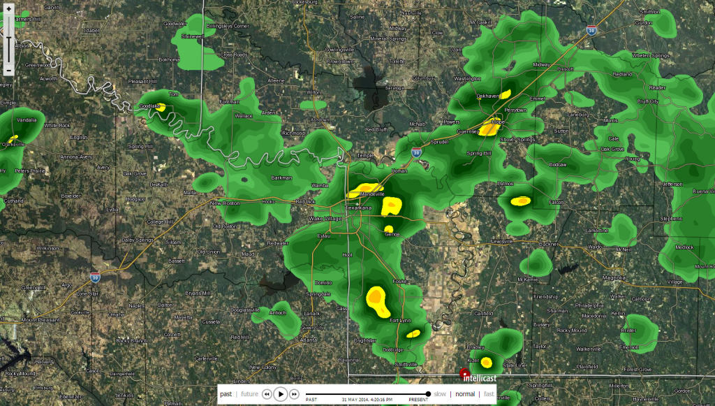
4th day in a row that the Texarkana area has received rain from the Upper Level Low:

0 likes
-
aggiecutter
- Category 5
- Posts: 1755
- Joined: Thu Oct 14, 2004 9:22 pm
- Location: Texarkana
Return to “USA & Caribbean Weather”
Who is online
Users browsing this forum: Stratton23 and 67 guests