
MDR looks active on the 12z run.
http://www.tropicaltidbits.com/analysis/models/gfs/2014072612/gfs_mslp_pcpn_atltropics_26.png
Global model runs discussion
Moderator: S2k Moderators
Re: Global Model Runs Discussion
0 likes
The following post is NOT an official forecast and should not be used as such. It is just the opinion of the poster and may or may not be backed by sound meteorological data. It is NOT endorsed by any professional institution including storm2k.org For Official Information please refer to the NHC and NWS products.
-
gatorcane

- S2K Supporter

- Posts: 23708
- Age: 48
- Joined: Sun Mar 13, 2005 3:54 pm
- Location: Boca Raton, FL
We'll need to see if this is a trend or not, but could be seeing some hints conditions could be more favorable across the MDR this year.
Last edited by gatorcane on Sat Jul 26, 2014 11:34 am, edited 1 time in total.
0 likes
-
stormlover2013
Re: Global Model Runs Discussion
If you get 3-4 storms in August and 3-4 in sept that's pretty active in a 2 month span it's about to start getting active!!!! Just my opinion
0 likes

Re: Global Model Runs Discussion
I'm noticing a steady line of vorticity from the Caribbean to Africa in the Euro, could this be an indication of lowering pressures and a general trend towards slightly more favorable conditions?
0 likes
The above post is not official and should not be used as such. It is the opinion of the poster and may or may not be backed by sound meteorological data. It is not endorsed by any professional institution or storm2k.org. For official information, please refer to the NHC and NWS products.
-
ninel conde
Re: Global Model Runs Discussion
There back... The two areas are back on the 00z run. Look a little stronger too.
http://www.tropicaltidbits.com/analysis/models/gfs/2014072700/gfs_mslp_pcpn_atltropics_21.png
http://www.tropicaltidbits.com/analysis/models/gfs/2014072700/gfs_mslp_pcpn_atltropics_21.png
0 likes
The following post is NOT an official forecast and should not be used as such. It is just the opinion of the poster and may or may not be backed by sound meteorological data. It is NOT endorsed by any professional institution including storm2k.org For Official Information please refer to the NHC and NWS products.
-
Hurricaneman

- Category 5

- Posts: 7404
- Age: 45
- Joined: Tue Aug 31, 2004 3:24 pm
- Location: central florida
Re: Global Model Runs Discussion
blp wrote:There back... The two areas are back on the 00z run. Look a little stronger too.
http://www.tropicaltidbits.com/analysis/models/gfs/2014072700/gfs_mslp_pcpn_atltropics_21.png
this has to be taken with a grain of salt because of the recent history of the GFS but the fact that a lot of other models have it too makes it alot more plausible
The posts in this forum are NOT official forecast and should not be used as such. They are just the opinion of the poster and may or may not be backed by sound meteorological data. They are NOT endorsed by any professional institution or storm2k.org. For official information, please refer to the NHC and NWS products
0 likes
The GFS had a horrible track record last year and tended to develop 2-3 as may storms that actually formed, but after the issues in June they seem to have tweaked it and then it failed miserably on Arthur's intensity (badly underdoing it) and failed to develop TD2. There is a definate trend emerging with the models though.
0 likes
The above post is not official and should not be used as such. It is the opinion of the poster and may or may not be backed by sound meteorological data. It is not endorsed by any professional institution or storm2k.org. For official information, please refer to the NHC and NWS products.
-
WPBWeather

- S2K Supporter
- Posts: 535
- Age: 67
- Joined: Thu Jul 18, 2013 12:33 pm
Re:
ninel conde wrote:no mention from JB and he likes to be first on everything.
Can you give it a rest, please!
0 likes
-
HURRICANELONNY
- Category 5
- Posts: 1390
- Joined: Wed May 07, 2003 6:48 am
- Location: HOLLYWOOD.FL
Re: Global Model Runs Discussion
I've been meandering through the posts last couple of weeks. Yea a couple negative nellys that try to debunk the tropics every year . Like were suppose to have 10 names storms by now. Ya have to look back at climo to realize were not in the busy season yet. I know all the pro mets are saying normal to below normal with the common denominator being El Nino. Righrt now were still neutral and even though the SST"s are not 2005 in the MDR. Does not mean no names. As aug-oct come. I think as usual things will ramp up. Already the NHC gives the wave off Africa a 0%-40%. Everyone should be prepared for the worst and hope for the best. 
PS
Sorry for posting on subject other the models. Had to get that out.
PS
Sorry for posting on subject other the models. Had to get that out.
0 likes
hurricanelonny
-
tolakram
- Admin

- Posts: 20170
- Age: 62
- Joined: Sun Aug 27, 2006 8:23 pm
- Location: Florence, KY (name is Mark)
Re:
Hammy wrote:The GFS had a horrible track record last year and tended to develop 2-3 as may storms that actually formed, but after the issues in June they seem to have tweaked it and then it failed miserably on Arthur's intensity (badly underdoing it) and failed to develop TD2. There is a definate trend emerging with the models though.
You have to look at how a model fails to better predict how well it's doing, in my opinion. The GFS failed with Arthur due to a track error that kept it over land, and therefor no development. With these storms out in the Atlantic that is usually not the case, but the current Euro takes this wave and moves it almost due West into the southern Caribbean or into SA. That's pretty typical for the Euro in the eastern Atlantic.
Unfortunately, every year, we have to tolerate those who believe the current conditions will persist but have no reasoning as to why, and over reliance on a single model to predict development. Last year the bad conditions persisted throughout the season and the euro did quite well at predicting no development.
So how bout those models?
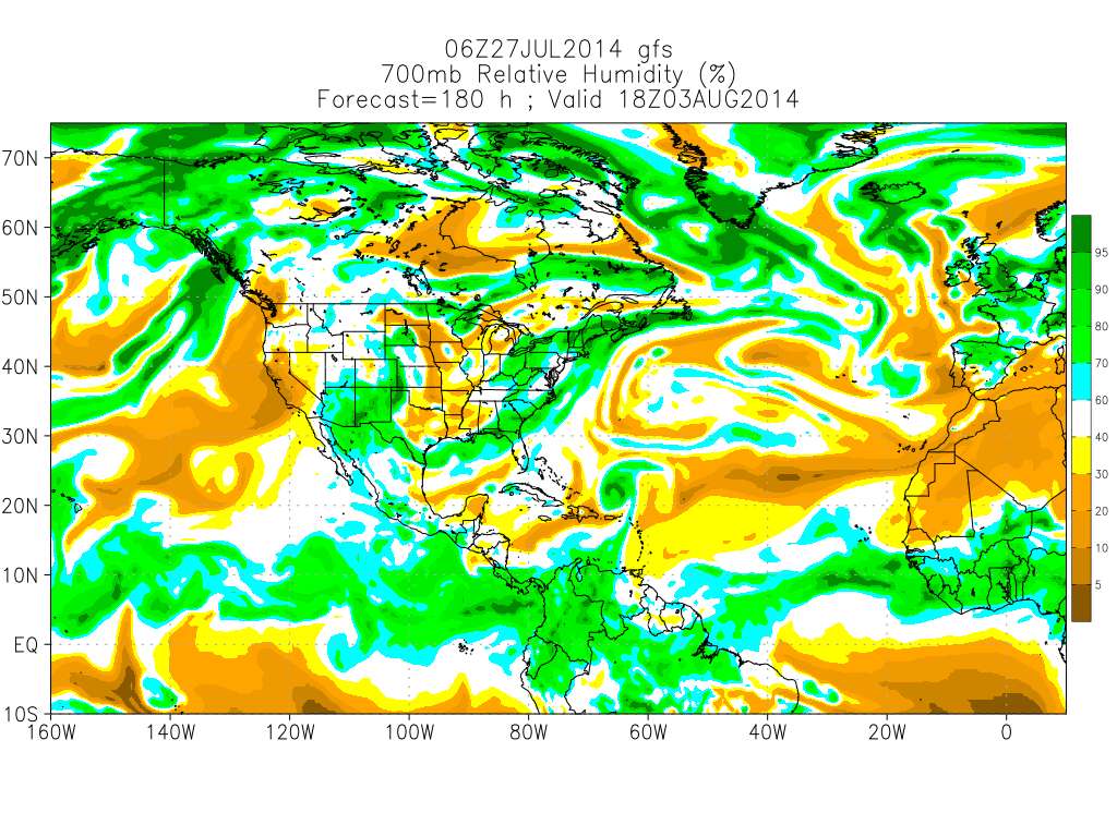
I'm fixated on watching the relative humidity plots this year, though I'm not sure if the humidity will increase development chances, or development increases humidity. Is this, like instability, a leading or trailing indicator?
700MB RH from the GFS


0 likes
M a r k
- - - - -
Join us in chat: Storm2K Chatroom Invite. Android and IOS apps also available.
The posts in this forum are NOT official forecasts and should not be used as such. Posts are NOT endorsed by any professional institution or STORM2K.org. For official information and forecasts, please refer to NHC and NWS products.
-
hurricanehunter69
- Category 1

- Posts: 344
- Joined: Sun May 16, 2010 5:21 pm
- Location: New Orleans
Re: Global Model Runs Discussion
GFS starting to hint at a possible second invest...? http://mag.ncep.noaa.gov/Image.php?fhr= ... =&ps=model
0 likes
-
HURRICANELONNY
- Category 5
- Posts: 1390
- Joined: Wed May 07, 2003 6:48 am
- Location: HOLLYWOOD.FL
-
HURRICANELONNY
- Category 5
- Posts: 1390
- Joined: Wed May 07, 2003 6:48 am
- Location: HOLLYWOOD.FL
Re: Re:
TheStormExpert wrote:HURRICANELONNY wrote:Like I said earlier. I think 93l is the locomotive of more moisture in the Atlantic.
I'll believe it when I see it!
Looks a little better behind 93L:
http://www.goes.noaa.gov/HURRLOOPS/atwv.html
0 likes
hurricanelonny
-
TheStormExpert
Re: Re:
HURRICANELONNY wrote:TheStormExpert wrote:HURRICANELONNY wrote:Like I said earlier. I think 93l is the locomotive of more moisture in the Atlantic.
I'll believe it when I see it!
Looks a little better behind 93L:
http://www.goes.noaa.gov/HURRLOOPS/atwv.html
Were gonna need a BIG! plume of moisture to somehow come off the west coast of Africa for anything to even try and really get it's act together this season.
0 likes

-
TheStormExpert
Re:
gatorcane wrote:The 00Z ECMWF shows a large wave emerging off of Africa in 10 days...just in time for the start of the Cape Verde season which generally starts in mid August.
http://i59.tinypic.com/ev77ec.jpg
I guess it's one thing if the good 'ol Euro shows it since it's been gold so far this season, and the GFS has literally snooped down to the Crazy CMC's level.
But IT WILL LIKELY CHANGE and probably towards a much weaker solution similar to the fate of 93L.
0 likes
Who is online
Users browsing this forum: No registered users and 17 guests