ATL: GONZALO - Post-Tropical - Discussion
Moderator: S2k Moderators
-
ozonepete
- Professional-Met

- Posts: 4743
- Joined: Mon Sep 07, 2009 3:23 pm
- Location: From Ozone Park, NYC / Now in Brooklyn, NY
Re: ATL: GONZALO - Hurricane - Discussion
spiral wrote:I think its got about another 5 knots to its peak of 115 you mention continued strengthening what peak are you thinking at nailing this at.
Well if I could nail hurricane strengths I would be a star in hurricane forecasting.
0 likes

Re: ATL: GONZALO - Hurricane - Discussion
Plane headed west, looks like the mission is over.
0 likes
The above post is not official and should not be used as such. It is the opinion of the poster and may or may not be backed by sound meteorological data. It is not endorsed by any professional institution or storm2k.org. For official information, please refer to the NHC and NWS products.
Is there still some shear from the east? It looks like the eyewall may have taken in a very tiny amount of dry air, but just enough to halt intensification in the immediate few hours.
0 likes
The above post is not official and should not be used as such. It is the opinion of the poster and may or may not be backed by sound meteorological data. It is not endorsed by any professional institution or storm2k.org. For official information, please refer to the NHC and NWS products.
-
ozonepete
- Professional-Met
- Posts: 4743
- Joined: Mon Sep 07, 2009 3:23 pm
- Location: From Ozone Park, NYC / Now in Brooklyn, NY
Re:
Hammy wrote:Is there still some shear from the east? It looks like the eyewall may have taken in a very tiny amount of dry air, but just enough to halt intensification in the immediate few hours.
? Don't see that at all. The eyewall is solidly built now and has never looked better. Also, remember that TCs, especially the stronger ones, often pulse up and down or pause during the strengthening process. You have to look at 3 hour or better yet 6 hour intervals to see the general pattern, just as we do with track to account for wobbles.
0 likes
-
EquusStorm
- Category 5

- Posts: 1649
- Age: 35
- Joined: Thu Nov 07, 2013 1:04 pm
- Location: Jasper, AL
- Contact:
It looks to me that the rapid intensification has slowed a little for the moment, though the eyewall looks a little more impressive than it did. I think it'll resume later, but with slightly less time to intensify overall. That said, I've certainly seen less organized category four storms.
0 likes
Colors of lost purpose on the canvas of irrelevance
Not a meteorologist, in fact more of an idiot than anything. You should probably check with the NHC or a local NWS office for official information.
Not a meteorologist, in fact more of an idiot than anything. You should probably check with the NHC or a local NWS office for official information.


-
ozonepete
- Professional-Met
- Posts: 4743
- Joined: Mon Sep 07, 2009 3:23 pm
- Location: From Ozone Park, NYC / Now in Brooklyn, NY
Re: Re:
spiral wrote:Hammy wrote:Is there still some shear from the east? It looks like the eyewall may have taken in a very tiny amount of dry air, but just enough to halt intensification in the immediate few hours.
If you look at ozonepete's image would have agree with shear hammy cause it clearly is very tilted.
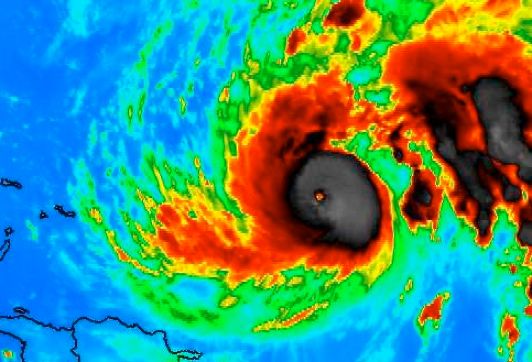
No that's not tilting at all. On my last image what you see is that the core ring of thunderstorms was thick on the east side of the storm and much less so on the western side. But that has nothing to do with tilting of the circulation from the surface up to the higher levels. That just means the convection is spiraling and wrapping around the center and it is normally wider in coverage on one side as compared to the other. It's only in really well developed powerful storms where the convective ring is the same width on all sides of the eye. It doesn't have to be that way to get a category 4 but pretty much has to be to get a cat 5 though. And now watch the loops - the western side of the eye has thicker convection now. That tells you that it's still strengthening.
0 likes
-
EquusStorm
- Category 5
- Posts: 1649
- Age: 35
- Joined: Thu Nov 07, 2013 1:04 pm
- Location: Jasper, AL
- Contact:
-
cycloneye

- Admin

- Posts: 149508
- Age: 69
- Joined: Thu Oct 10, 2002 10:54 am
- Location: San Juan, Puerto Rico
Re: ATL: GONZALO - Hurricane - Discussion

0 likes
Visit the Caribbean-Central America Weather Thread where you can find at first post web cams,radars
and observations from Caribbean basin members Click Here
and observations from Caribbean basin members Click Here
-
hurricanes1234
- Category 5
- Posts: 2908
- Joined: Sat Jul 28, 2012 6:19 pm
- Location: Trinidad and Tobago
Highest wind speed in an Atlantic hurricane since Ophelia from 2011.
0 likes
PLEASE NOTE: With the exception of information from weather agencies that I may copy and paste here, my posts will NEVER be official, since I am NOT a meteorologist. They are solely my amateur opinion, and may or may not be accurate. Therefore, please DO NOT use them as official details, particularly when making important decisions. Thank you.
-
HurricaneRyan
- Category 3

- Posts: 846
- Age: 32
- Joined: Sun Dec 05, 2010 3:05 pm
-
weatherfanatic
- Tropical Depression

- Posts: 58
- Age: 44
- Joined: Sun Jun 29, 2014 7:52 am
- Location: Yonkers, NY
This is one insane storm, 970mb to 954mb in 6 hrs wow. If this keeps intensifying who knows the track, I heard that once they get this strong you cannot always predict as well what it will do. ULL will more than likely keep it far away from the US, but I noted one ensemble member bringing iit over northern maine.
0 likes
This post is NOT AN OFFICIAL FORECAST and should not be used as such. It is just the opinion of the poster and may or may not be backed by sound meteorological data. It is NOT endorsed by any professional institution including storm2k.org. For Official Information please refer to the NHC and NWS products.
-
CrazyC83
- Professional-Met
- Posts: 34315
- Joined: Tue Mar 07, 2006 11:57 pm
- Location: Deep South, for the first time!
Re:
weatherfanatic wrote:This is one insane storm, 970mb to 954mb in 6 hrs wow. If this keeps intensifying who knows the track, I heard that once they get this strong you cannot always predict as well what it will do. ULL will more than likely keep it far away from the US, but I noted one ensemble member bringing iit over northern maine.
The negative tilt of the trough might try to turn it?
0 likes
-
beoumont

- Category 1

- Posts: 473
- Joined: Sun Jul 10, 2011 4:13 pm
- Location: East Central Florida
- Contact:
Re: ATL: GONZALO - Hurricane - Discussion
NASTY!
0 likes
List of 79 tropical cyclones intercepted by Richard Horodner:
http://www.canebeard.com/page/page/572246.htm
http://www.canebeard.com/page/page/572246.htm
-
TheStormExpert
-
TheStormExpert
Re: ATL: GONZALO - Hurricane - Discussion
beoumont wrote:NASTY!
Looks nasty, but I've seen better looking major hurricanes, but looks aren't always everything!
0 likes
-
weatherfanatic
- Tropical Depression
- Posts: 58
- Age: 44
- Joined: Sun Jun 29, 2014 7:52 am
- Location: Yonkers, NY
CrazyC83, that wouldnt be a good thing to have a sudden unforseen turn toward the US. Doubtful, the trough will keep it well offshore. Then again nothing is impossible in the world of the tropics, we all thought the season was dead as a doornail, and now we have near a cat 4!
0 likes
This post is NOT AN OFFICIAL FORECAST and should not be used as such. It is just the opinion of the poster and may or may not be backed by sound meteorological data. It is NOT endorsed by any professional institution including storm2k.org. For Official Information please refer to the NHC and NWS products.
Definitely some internal structure problems going on now, it looks like the eyewall is probably open to the SW now, and the convective area is weakening slightly and strengthening. Despite what appeared earlier to be the start of RI, I dare say this may have peaked already, at least for the next 12-24 hours.
0 likes
The above post is not official and should not be used as such. It is the opinion of the poster and may or may not be backed by sound meteorological data. It is not endorsed by any professional institution or storm2k.org. For official information, please refer to the NHC and NWS products.
Who is online
Users browsing this forum: No registered users and 28 guests