ATL: Ex NINE
Moderator: S2k Moderators
-
gatorcane

- S2K Supporter

- Posts: 23703
- Age: 47
- Joined: Sun Mar 13, 2005 3:54 pm
- Location: Boca Raton, FL
Re: ATL: INVEST 94L - Discussion
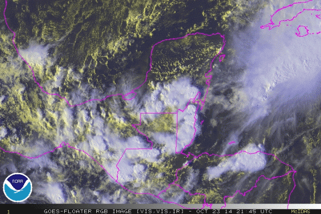
Not as much vorticity as it had early but I still see some broad cyclonic turning heading ESE in the South Central area of the Yucatan, convection building now on the E side of this broad low.
Last edited by gatorcane on Thu Oct 23, 2014 3:34 pm, edited 3 times in total.
0 likes
-
Miami Storm Tracker

- Category 4

- Posts: 916
- Age: 68
- Joined: Sun Jun 13, 2010 10:12 pm
- Location: Key Largo, Fla.
- Contact:
Re: ATL: INVEST 94L - Discussion
Good Afternoon,
There may not be a low level circulation in the Yucatan. But looking at the rain and clouds here in Miami something is causing them to move in opposite directions as if a low was forming in this area.
There may not be a low level circulation in the Yucatan. But looking at the rain and clouds here in Miami something is causing them to move in opposite directions as if a low was forming in this area.
0 likes
-
SeGaBob
-
wxman57

- Moderator-Pro Met

- Posts: 23120
- Age: 68
- Joined: Sat Jun 21, 2003 8:06 pm
- Location: Houston, TX (southwest)
Re:
SeGaBob wrote:I hope this reforms just to prove people wrong (not too strong though.) I'm tired of people being negative all the time.
This was a very good year to be "negative", particularly in the Caribbean or the MDR. I'll be positive, though. I'm positive this system has very little chance of developing.
0 likes
-
TheStormExpert

-
Dean4Storms
- S2K Supporter
- Posts: 6358
- Age: 62
- Joined: Sun Aug 31, 2003 1:01 pm
- Location: Miramar Bch. FL
I think this ship has sailed. At some point, one must wake up to reality. Also, never bet against Mr. "57". He's not nearly always right but his % is pretty darn good. Bones may be trotted out within the next day or so.
Last edited by LarryWx on Thu Oct 23, 2014 3:50 pm, edited 1 time in total.
0 likes
Personal Forecast Disclaimer:
The posts in this forum are NOT official forecasts and should not be used as such. They are just the opinion of the poster and may or may not be backed by sound meteorological data. They are NOT endorsed by any professional institution or storm2k.org. For official information, please refer to the NHC and NWS products.
The posts in this forum are NOT official forecasts and should not be used as such. They are just the opinion of the poster and may or may not be backed by sound meteorological data. They are NOT endorsed by any professional institution or storm2k.org. For official information, please refer to the NHC and NWS products.
-
TheStormExpert
Re:
Dean4Storms wrote:I see a weak circulation, don't know about anyone else. Hard to say though if it regenerates over the water once it gets there tomorrow.
The only chance it has at regenerating is if overall conditions (shear, dry air, etc.) do a 180° flip, which seems highly unlikely due to the passage of that strong front that has been well advertised to bring Cool/Dry Air advection into the NW Caribbean.
0 likes
-
TheStormExpert
Re:
LarryWx wrote:I think this ship has sailed. At some point, one must wake up to reality. Also, never bet against Mr. "57". He's not nearly always right but his % is pretty darn good. Bones may be trotted out within the next day or so.
Bones will be here very shortly by the looks of it.
0 likes
-
TropicalAnalystwx13

- Category 5

- Posts: 2109
- Age: 28
- Joined: Tue Jul 19, 2011 8:20 pm
- Location: Wilmington, NC
- Contact:
Too many times have meteorologists turned a blind eye to a dead system just to have it turn around and bite them later (Katrina is a great example). While the GFS has backed off from the solution it was showing over the past few days, consider that wind shear across the West Caribbean will lessen as the troughing over the East United States lifts out (below 10kts in the days 4-5 period according to the SHIPS) and consider how warm the waters are and how deep the warm waters span in the West Caribbean. It's something to watch carefully, even if regeneration chances currently seem low.
0 likes
-
HURRICANELONNY
- Category 5
- Posts: 1390
- Joined: Wed May 07, 2003 6:48 am
- Location: HOLLYWOOD.FL
Discussion by Dr. Jeff Masters:
By Saturday, some of the spin associated with TD 9 may emerge over the Western Caribbean, and we should carefully watch this area on Sunday and Monday for tropical cyclone development--though none of our reliable models were predicting development in their Thursday morning runs. A trough of low pressure connected to the large Nor'easter affecting the Northeast U.S. will inject a large amount of dry air into the Western Caribbean this weekend, discouraging development, and wind shear is expected to be a rather high 15 - 25 knots, which should keep any development slow. If development does occur, Honduras, Belize, and Mexico's Yucatan Peninsula would be most at risk of receiving impacts from the storm.
By Saturday, some of the spin associated with TD 9 may emerge over the Western Caribbean, and we should carefully watch this area on Sunday and Monday for tropical cyclone development--though none of our reliable models were predicting development in their Thursday morning runs. A trough of low pressure connected to the large Nor'easter affecting the Northeast U.S. will inject a large amount of dry air into the Western Caribbean this weekend, discouraging development, and wind shear is expected to be a rather high 15 - 25 knots, which should keep any development slow. If development does occur, Honduras, Belize, and Mexico's Yucatan Peninsula would be most at risk of receiving impacts from the storm.
0 likes
hurricanelonny
-
northjaxpro

- S2K Supporter
- Posts: 8900
- Joined: Mon Sep 27, 2010 11:21 am
- Location: Jacksonville, FL
Re:
TropicalAnalystwx13 wrote:Too many times have meteorologists turned a blind eye to a dead system just to have it turn around and bite them later (Katrina is a great example). While the GFS has backed off from the solution it was showing over the past few days, consider that wind shear across the West Caribbean will lessen as the troughing over the East United States lifts out (below 10kts in the days 4-5 period according to the SHIPS) and consider how warm the waters are and how deep the warm waters span in the West Caribbean. It's something to watch carefully, even if regeneration chances currently seem low.
Excellent discertation TA13. I agree with you with this post.
Last edited by northjaxpro on Thu Oct 23, 2014 5:05 pm, edited 1 time in total.
0 likes
NEVER, EVER SAY NEVER in the tropics and weather in general, and most importantly, with life itself!!
________________________________________________________________________________________
Fay 2008 Beryl 2012 Debby 2012 Colin 2016 Hermine 2016 Julia 2016 Matthew 2016 Irma 2017 Dorian 2019
________________________________________________________________________________________
Fay 2008 Beryl 2012 Debby 2012 Colin 2016 Hermine 2016 Julia 2016 Matthew 2016 Irma 2017 Dorian 2019
-
CYCLONE MIKE
- Category 5
- Posts: 2183
- Joined: Tue Aug 31, 2004 6:04 pm
- Location: Gonzales, LA
Re:
SeGaBob wrote:I hope this reforms just to prove people wrong (not too strong though.) I'm tired of people being negative all the time.
For most its not being negative, its called being a realist. This was supposed to be the year of homebrews and have had absolutely nothing to even threaten besides Arthur.
0 likes
-
floridasun78
- Category 5
- Posts: 3755
- Joined: Sun May 17, 2009 10:16 pm
- Location: miami fl
-
ozonepete
- Professional-Met

- Posts: 4743
- Joined: Mon Sep 07, 2009 3:23 pm
- Location: From Ozone Park, NYC / Now in Brooklyn, NY
Re: ATL: INVEST 94L - Discussion
Nice convective blow-up starting in the right places around the low. I would put it at 20 or 30%. Note that the 12Z euro and GFS, although they don't develop it early next week, they do indeed show a closed low again east of the Yucatan on Saturday night/Sunday morning. I have a feeling this is going to play cat and mouse with us again lol.

0 likes


Who is online
Users browsing this forum: No registered users and 15 guests