Texas Fall-2014
Moderator: S2k Moderators
Forum rules

The posts in this forum are NOT official forecast and should not be used as such. They are just the opinion of the poster and may or may not be backed by sound meteorological data. They are NOT endorsed by any professional institution or STORM2K.
-
TeamPlayersBlue

- Category 5

- Posts: 3530
- Joined: Tue Feb 02, 2010 1:44 am
- Location: Denver/Applewood, CO
Officially 32 in Sugar Land. First freeze of the season. One of the earliest that i can remember as well
0 likes
Personal Forecast Disclaimer:
The posts in this forum are NOT official forecast and should not be used as such. They are just the opinion of the poster and may or may not be backed by sound meteorological data. They are NOT endorsed by any professional institution or storm2k.org. For official information, please refer to the NHC and NWS products.
The posts in this forum are NOT official forecast and should not be used as such. They are just the opinion of the poster and may or may not be backed by sound meteorological data. They are NOT endorsed by any professional institution or storm2k.org. For official information, please refer to the NHC and NWS products.
-
Texas Snowman

- Storm2k Moderator

- Posts: 6197
- Joined: Fri Jan 25, 2008 11:29 am
- Location: Denison, Texas
Re: Texas Fall-2014
GRAYSONCO.WX wrote:It looks like the guidance is hinting at some light precipitation being generated next Monday night/Tuesday morning for southern Oklahoma, and possibly northern Texas, as a piece of energy moves across the area. We may have to keep a close eye on this system as well as temperatures. Anyone else seeing this?
From OKC NWS forecast discussion this afternoon:
"MODELS SHOW AN UPPER TROUGH ALSO DIGGING AND MOVING ACROSS THE SW
U.S. LATER THIS WEEK AND MOVING ACROSS THE SOUTHERN PLAINS THIS
WEEKEND. THIS SYSTEM WILL BRING A BETTER CHANCE FOR RAIN AND SOME
THUNDERSTORMS... ESPECIALLY IN SE PORTIONS OF THE FA... FRIDAY NIGHT
INTO SATURDAY. MODELS THEN BEGIN TO DIFFER AS ANOTHER UPPER WAVE
APPROACHES AND MOVES ACROSS THE REGION CAUSING A COLD FRONT TO MOVE
ACROSS THE AREA. THE ECMWF IS FASTER WITH THIS FRONT WHICH WOULD
HAVE AN AFFECT ON THE TEMPERATURE FORECAST. MODELS ALSO SHOW SOME
LIGHT PRECIP MAY BE POSSIBLE IN NE PARTS OF THE FA WITH THIS WAVE
ALTHOUGH RIGHT NOW IT LOOKS LIKE MUCH OF THE PRECIP WILL REMAIN
NORTH AND EAST OF THE AREA. HOW FAST THE COLDER AIR MOVES INTO THE
FA COULD HAVE AN IMPACT ON PRECIP TYPE. RIGHT NOW HAVE A MENTION OF
A BRIEF PERIOD WHERE RAIN MAY CHANGE OVER TO SNOW SUNDAY NIGHT
BEFORE PRECIP MOVES EAST OF THE FA."
0 likes
The above post and any post by Texas Snowman is NOT an official forecast and should not be used as such. It is just the opinion of the poster and may or may not be backed by sound meteorological data. It is NOT endorsed by any professional institution including storm2k.org. For official information, please refer to NWS products.
-
TexasBreeze
- Tropical Depression

- Posts: 81
- Joined: Mon Jul 07, 2014 12:50 pm
This has nothing to do with Texas, but is an interesting tidbit. Some places just off the great lakes Erie and Ontario could see 70+ inches of snowfall with the lake-effect machine cranked up this week. I have family up there in Cleveland, OH! I could not imagine having that much snow!!!
http://forecast.weather.gov/showsigwx.p ... GvVrcnnbqA
http://forecast.weather.gov/showsigwx.p ... GvVrcnnbqA
0 likes

Re:
TexasBreeze wrote:This has nothing to do with Texas, but is an interesting tidbit. Some places just off the great lakes Erie and Ontario could see 70+ inches of snowfall with the lake-effect machine cranked up this week. I have family up there in Cleveland, OH! I could not imagine having that much snow!!!
http://forecast.weather.gov/showsigwx.p ... GvVrcnnbqA
Godly snow amounts. I think the latest report per TWC was 51" in Cheektowaga, NY. I wouldn't be suprised if someone from the Buffalo southern suburbs end up with over 100". Just crazy Lake effect event.
Can we petition to expand Lake Texoma N/S? Maybe stream some lake enhanced snows from northers
0 likes
The above post and any post by Ntxw is NOT an official forecast and should not be used as such. It is just the opinion of the poster and may or may not be backed by sound meteorological data. It is NOT endorsed by any professional institution including Storm2k. For official information, please refer to NWS products.
Help support Storm2K!

-
northjaxpro

- S2K Supporter

- Posts: 8900
- Joined: Mon Sep 27, 2010 11:21 am
- Location: Jacksonville, FL
Quite a discrepency with the GFS Parallel run at 240 hours and the 216 hr GFS . GFS Parallel dives the Arctic air down the spine of the Rockies and across the Great and Southern Plains. The 18Z 216 hr GFS has the trough digging over the Eastern CONUS all the way into the NE Gulf of Mexico on Thanksgiving Day.

0 likes
NEVER, EVER SAY NEVER in the tropics and weather in general, and most importantly, with life itself!!
________________________________________________________________________________________
Fay 2008 Beryl 2012 Debby 2012 Colin 2016 Hermine 2016 Julia 2016 Matthew 2016 Irma 2017 Dorian 2019
________________________________________________________________________________________
Fay 2008 Beryl 2012 Debby 2012 Colin 2016 Hermine 2016 Julia 2016 Matthew 2016 Irma 2017 Dorian 2019
-
wxman57

- Moderator-Pro Met

- Posts: 23172
- Age: 68
- Joined: Sat Jun 21, 2003 8:06 pm
- Location: Houston, TX (southwest)
Re: Texas Fall-2014
Good news (for me) today! Even though the high clouds nearly prevented it, the low for IAH managed to briefly reach 32F this morning. That means I won the first freeze contest, something I've been trying to do for about 15 years. I had the earliest date (Nov. 21st) of any entry, as I had feared the best analogs for 2014 were the extremely cold winter of 1976-77 and the early season cold of 1993-1994.
Now, the bad news (for you cold-lovers). I no longer wish for cold air. I'm back in full HEAT mode!
Time to get to work in driving this cold air back to the Arctic where it belongs!
CLIMATE REPORT
NATIONAL WEATHER SERVICE HOUSTON/GALVESTON TX
431 PM CST TUE NOV 18 2014
...THE HOUSTON INTERCONTINENTAL CLIMATE SUMMARY FOR NOVEMBER 18 2014...
VALID TODAY AS OF 400 PM LOCAL TIME.
TEMPERATURE (F)
TODAY
MAXIMUM 55 310 PM
[b] MINIMUM 32 550 AM[/b]
0 likes
-
wxman57
- Moderator-Pro Met
- Posts: 23172
- Age: 68
- Joined: Sat Jun 21, 2003 8:06 pm
- Location: Houston, TX (southwest)
Re:
gboudx wrote:What did you win? A wicker basket for your bike?
The prize is a $100 bill and the satisfaction of finally winning one of these contests after so many years. I missed out on the first cold front contest by 90 minutes, and Hanna knocked me out of the hurricane contest. Thought I had those two won last month.
0 likes

Re: Texas Fall-2014
wxman57 wrote:Now, the bad news (for you cold-lovers). I no longer wish for cold air. I'm back in full HEAT mode!
Time to get to work in driving this cold air back to the Arctic where it belongs!
Not if my anti-Wxman57 avatar has anything to say about it!
0 likes
-
Texas Snowman
- Storm2k Moderator
- Posts: 6197
- Joined: Fri Jan 25, 2008 11:29 am
- Location: Denison, Texas
Re:
gatorcane wrote:18Z PGFS dives the Arctic blast south at the end of the run in the long-range. 240 hours below with all of Texas colder than normal:
http://i57.tinypic.com/3588ar7.png
Now that is PERFECT bike riding weather, don't you think?
0 likes
The above post and any post by Texas Snowman is NOT an official forecast and should not be used as such. It is just the opinion of the poster and may or may not be backed by sound meteorological data. It is NOT endorsed by any professional institution including storm2k.org. For official information, please refer to NWS products.
-
BigB0882
- S2K Supporter
- Posts: 2292
- Joined: Thu Jul 03, 2003 12:08 am
- Location: Baton Rouge, LA
- Contact:
I have a friend who lives in the Buffalo area and he posted a picture of his backyard, the snow is up to the fence. Not sure how tall the fence is but I'd say they have a good 5-6 feet of snow!!!! The place is just completely buried. They can't even leave their house, no one can. Is it sick and twisted that I am a little jealous? lol
0 likes
Re:
BigB0882 wrote:I have a friend who lives in the Buffalo area and he posted a picture of his backyard, the snow is up to the fence. Not sure how tall the fence is but I'd say they have a good 5-6 feet of snow!!!! The place is just completely buried. They can't even leave their house, no one can. Is it sick and twisted that I am a little jealous? lol
Not at all! From a distance it's envious but from up close I'm sure it's a nightmare. Once you're forced to be stuck at home and can't even go out in it, that makes it obsolete on the fun part. I think it's too much at once
 .
.ravyrn wrote:Not if my anti-Wxman57 avatar has anything to say about it!
Kudos on the avatar, love it!
0 likes
The above post and any post by Ntxw is NOT an official forecast and should not be used as such. It is just the opinion of the poster and may or may not be backed by sound meteorological data. It is NOT endorsed by any professional institution including Storm2k. For official information, please refer to NWS products.
Help support Storm2K!
Help support Storm2K!
-
Nairobi

One more chilly morning across SE TX with temps ranging from the mid 30s to low 50s along the coast. The pattern change begins today as the winds veer SW and then SE over the upcoming days pumping in GOM moisture and warming temps into the 70s beginning tomorrow into the weekend. Energy around the Gulf Alaska low will dive across CA and develop into a sharp trough which will eventually setup over N MX and then lift NE across TX Saturday. The potential continues to increase for a severe weather event across TX beginning across W Central TX Friday and spreading across Central and SE TX Saturday. More details the next several days as the event approaches.
0 likes
The following post is NOT an official forecast and should not be used as such. It is just the opinion of the poster and may or may not be backed by sound meteorological data. It is NOT endorsed by any professional institution including storm2k.org For Official Information please refer to the NHC and NWS products.
-
Portastorm

- Storm2k Moderator
- Posts: 9955
- Age: 63
- Joined: Fri Jul 11, 2003 9:16 am
- Location: Round Rock, TX
- Contact:
Re: Texas Fall-2014
ravyrn wrote:wxman57 wrote:Now, the bad news (for you cold-lovers). I no longer wish for cold air. I'm back in full HEAT mode!
Time to get to work in driving this cold air back to the Arctic where it belongs!
Not if my anti-Wxman57 avatar has anything to say about it!
ravyrn, that avatar is an absolute Storm 2K Classic!
0 likes
Any forecasts under my name are to be taken with a grain of salt. Get your best forecasts from the National Weather Service and National Hurricane Center.
Re: Texas Fall-2014
Something is definitely funky when it gets 26deg here in Houma La in November. Hell it's been 80 degrees for Thanksgiving before around here. This winter might be one you remember for a while.
0 likes
The following post is NOT an official forecast and should not be used as such. It is just the opinion of the poster and may or may not be backed by sound meteorological data. It is NOT endorsed by any professional institution including storm2k.org For Official Information please refer to the NHC and NWS products.
-
wxman57
- Moderator-Pro Met
- Posts: 23172
- Age: 68
- Joined: Sat Jun 21, 2003 8:06 pm
- Location: Houston, TX (southwest)
Re: Texas Fall-2014
I think that this winter is not going to be a pleasant one for me. I remember the 1976-77 winter well. The Mississippi froze down to St. Louis. New Orleans reported ice floating down the river at times. There was measurable snow in Miami. Meanwhile, U.S. troops on Arctic maneuvers in Alaska suffered from heat exhaustion. Perhaps I should move to Alaska this winter?
A picture from East Lancaster (near Buffalo) below. The good news for them is that the lake-effect snow will stop early this year when the lakes freeze over.
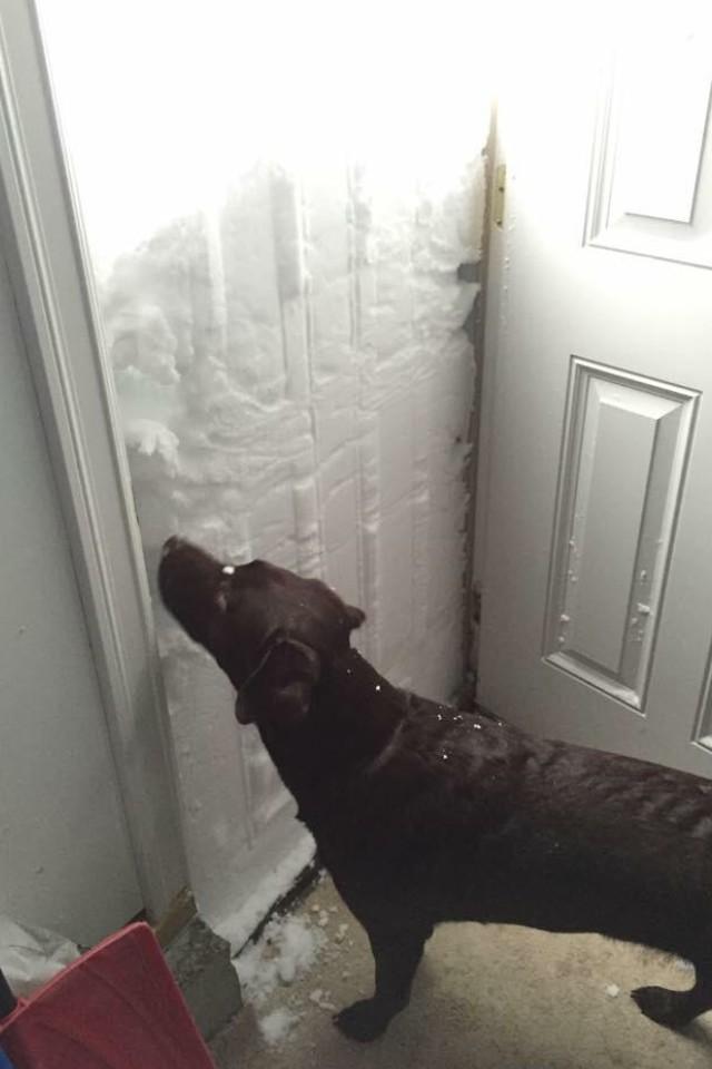
A picture from East Lancaster (near Buffalo) below. The good news for them is that the lake-effect snow will stop early this year when the lakes freeze over.
0 likes
-
gatorcane

- S2K Supporter
- Posts: 23708
- Age: 48
- Joined: Sun Mar 13, 2005 3:54 pm
- Location: Boca Raton, FL
Wow amazing picture Wxman. That is cold!  The Parallel GFS and ECMWF runs continues to show another arctic intrusion into the lower 48 again east of the rockies in the long-range. Day 10 below. Timing and details need to be worked out.
00Z GFS 10 Day:

06Z GFS 10 Day:

00Z ECMWF 10 Day:

00Z GFS 10 Day:
06Z GFS 10 Day:
00Z ECMWF 10 Day:
Last edited by gatorcane on Wed Nov 19, 2014 9:40 am, edited 6 times in total.
0 likes
Return to “USA & Caribbean Weather”
Who is online
Users browsing this forum: No registered users and 72 guests