Texas Winter 2014-2015

Winter Weather Discussion

Moderator: S2k Moderators

Forum rules

The posts in this forum are NOT official forecast and should not be used as such. They are just the opinion of the poster and may or may not be backed by sound meteorological data. They are NOT endorsed by any professional institution or STORM2K.

Help Support Storm2K
Message
Author
User avatar
Tireman4
S2K Supporter
S2K Supporter
Posts: 5853
Age: 59
Joined: Fri Jun 30, 2006 1:08 pm
Location: Humble, Texas
Contact:

Re:

#781 Postby Tireman4 » Tue Dec 16, 2014 6:09 pm

Texas Snowman wrote::uarrow: I'm counting on you using that snow machine next week.

While I sit here and listen to Bing Crosby croon about dreaming of another white Christmas with every Christmas card he writes.

Which reminds me, I need to send a special card to someone - with a snowball in it. :froze:

Anyone have the address for Wxman 57?!? :D :D

Seriously, Merry Christmas Heat Miser. May you get plenty of 80 and 90 degree days...next summer!


Yep...

400 Degrees Fahrenheit Road
Boiling Point, Texas, 78220


:)
0 likes   

User avatar
TeamPlayersBlue
Category 5
Category 5
Posts: 3445
Joined: Tue Feb 02, 2010 1:44 am
Location: Denver/Applewood, CO

#782 Postby TeamPlayersBlue » Tue Dec 16, 2014 6:14 pm

Seeing all those mid-Dec 1989 analogs..... If only that were a precursor to something else happening just after that time frame.....
0 likes   
Personal Forecast Disclaimer:
The posts in this forum are NOT official forecast and should not be used as such. They are just the opinion of the poster and may or may not be backed by sound meteorological data. They are NOT endorsed by any professional institution or storm2k.org. For official information, please refer to the NHC and NWS products.

User avatar
gatorcane
S2K Supporter
S2K Supporter
Posts: 23691
Age: 47
Joined: Sun Mar 13, 2005 3:54 pm
Location: Boca Raton, FL

#783 Postby gatorcane » Tue Dec 16, 2014 6:46 pm

18Z GFS scrapes Texas on this run with this Arctic blast, 276 and 300 hours below. Look at all that cold air building up in Canada :cold:

Image

Image
0 likes   

User avatar
Ntxw
Storm2k Moderator
Storm2k Moderator
Posts: 22786
Joined: Wed Oct 21, 2009 6:34 pm
Location: DFW, Texas

#784 Postby Ntxw » Tue Dec 16, 2014 9:26 pm

Raw day tomorrow for DFW. Highs should top around 45 and cold rain kicks in the afternoon. Dress accordingly.
0 likes   
The above post and any post by Ntxw is NOT an official forecast and should not be used as such. It is just the opinion of the poster and may or may not be backed by sound meteorological data. It is NOT endorsed by any professional institution including Storm2k. For official information, please refer to NWS products.

  Help support Storm2K!
Help Support Storm2K

User avatar
Rgv20
S2K Supporter
S2K Supporter
Posts: 2466
Age: 38
Joined: Wed Jan 05, 2011 5:42 pm
Location: Edinburg/McAllen Tx

#785 Postby Rgv20 » Wed Dec 17, 2014 12:08 am

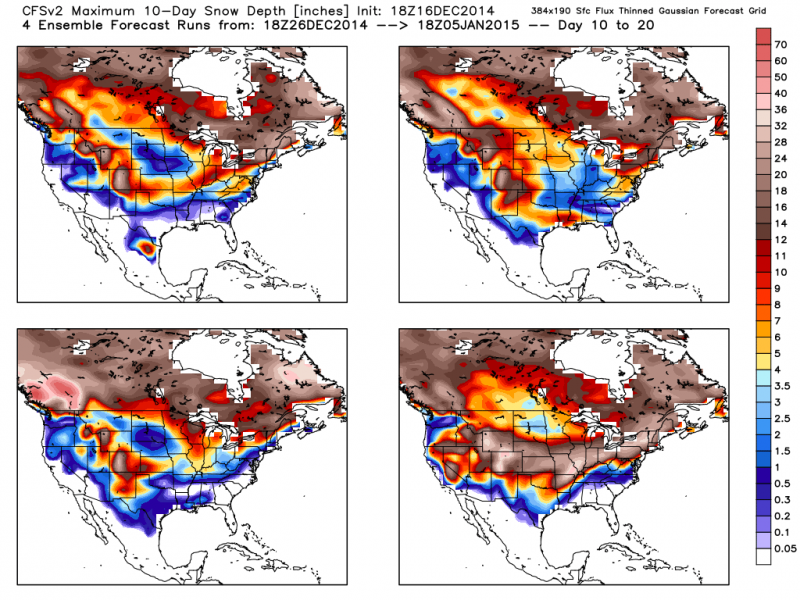
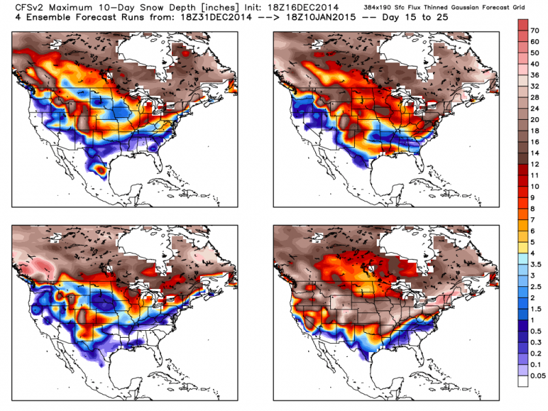
CFSv2 has some winter fun for most of Texas from the 26 to the end of the month and then the first 10 days of January.. :D

Late December
Image

Early January
Image
0 likes   
The following post is NOT an official forecast and should not be used as such. It is just the opinion of the poster and may or may not be backed by sound meteorological data. It is NOT endorsed by any professional institution including storm2k.org For Official Information please refer to the NHC and NWS products.

orangeblood
S2K Supporter
S2K Supporter
Posts: 3714
Joined: Tue Dec 15, 2009 6:14 pm
Location: Fort Worth, TX

Re: Texas Winter 2014-2015

#786 Postby orangeblood » Wed Dec 17, 2014 12:17 am

:uarrow: Yeah, CFSv2 is following suit with the other models....directly in line with the Euro and Canadian Control Runs, showing a 10-15 day period total average of 10-15 Deg F below normal starting just before New Years. For such a sustained period of time that is brutal Cold, if it came close to verifying.

GFS is in lala land once again, has no clue how to handle a complex pattern change. Unfortunately, I've been hearing rumors that the physics of the model hasn't changed much, just the scale. Hopefully there isn't much truth to that, that model is way over due for some drastic changes!
0 likes   

User avatar
Rgv20
S2K Supporter
S2K Supporter
Posts: 2466
Age: 38
Joined: Wed Jan 05, 2011 5:42 pm
Location: Edinburg/McAllen Tx

#787 Postby Rgv20 » Wed Dec 17, 2014 12:26 am

:uarrow: The 12zECMWF Ensemble Mean 500mb Anomalies in the 10-15 day period is just amazing if you like cold weather, it has a lot of blocking in Alaska and a wide open road for Siberian/Arctic air to plunge directly to the US.
0 likes   
The following post is NOT an official forecast and should not be used as such. It is just the opinion of the poster and may or may not be backed by sound meteorological data. It is NOT endorsed by any professional institution including storm2k.org For Official Information please refer to the NHC and NWS products.

BigB0882
S2K Supporter
S2K Supporter
Posts: 2284
Joined: Thu Jul 03, 2003 12:08 am
Location: Baton Rouge, LA
Contact:

#788 Postby BigB0882 » Wed Dec 17, 2014 12:56 am

3 of the 4 maps show snow all the way to the Gulf Coast, one of them showing 7+ inches for almost all of Louisiana. That would be unreal. I have no idea how dependable those maps are. They seem to often show us having snow and it rarely, if ever, pans out. Maybe this time it is right? One can dream.
0 likes   

User avatar
Texas Snowman
Storm2k Moderator
Storm2k Moderator
Posts: 6179
Joined: Fri Jan 25, 2008 11:29 am
Location: Denison, Texas

Re:

#789 Postby Texas Snowman » Wed Dec 17, 2014 1:19 am

BigB0882 wrote:3 of the 4 maps show snow all the way to the Gulf Coast, one of them showing 7+ inches for almost all of Louisiana. That would be unreal. I have no idea how dependable those maps are. They seem to often show us having snow and it rarely, if ever, pans out. Maybe this time it is right? One can dream.


I'm sure Wxman 57 will tell us all how undependable and unreliable they are in the morning. :lol:
0 likes   
The above post and any post by Texas Snowman is NOT an official forecast and should not be used as such. It is just the opinion of the poster and may or may not be backed by sound meteorological data. It is NOT endorsed by any professional institution including storm2k.org. For official information, please refer to NWS products.

User avatar
South Texas Storms
Professional-Met
Professional-Met
Posts: 4226
Joined: Thu Jun 24, 2010 12:28 am
Location: Houston, TX

Re: Texas Winter 2014-2015

#790 Postby South Texas Storms » Wed Dec 17, 2014 2:01 am

0z Euro is indicating a very cold airmass will move south into Texas in about 10 days. It's showing snow in Oklahoma and the Texas Panhandle as the run ends.

Image
0 likes   

Kennethb
Category 2
Category 2
Posts: 506
Joined: Thu Aug 14, 2003 7:15 am
Location: Baton Rouge

Re:

#791 Postby Kennethb » Wed Dec 17, 2014 5:12 am

BigB0882 wrote:3 of the 4 maps show snow all the way to the Gulf Coast, one of them showing 7+ inches for almost all of Louisiana. That would be unreal. I have no idea how dependable those maps are. They seem to often show us having snow and it rarely, if ever, pans out. Maybe this time it is right? One can dream.


BigB. I have lived in Baton Rouge for many decades. Those maps are very unreliable, especially for the deep south. That shows about 30 years total of snow fall in Baton Rouge on one map/at one time. But you never know. Last winter we just missed a snow like that twice in a week. If we could have gotten rid of that warm nose just a few thousand feet above us last January it would have been a dream like these maps.
Last edited by Kennethb on Wed Dec 17, 2014 6:39 am, edited 1 time in total.
0 likes   

User avatar
somethingfunny
ChatStaff
ChatStaff
Posts: 3926
Age: 37
Joined: Thu May 31, 2007 10:30 pm
Location: McKinney, Texas

#792 Postby somethingfunny » Wed Dec 17, 2014 5:27 am

My eye is around New Years for a snow threat. Until then, it's a few rounds of drought relief, a few rounds of cooling temps, a few rounds of growing snowpack to our north........

We can't expect any instant gratification and the first snow threat will likely fail, but patience will pay off.
0 likes   
I am not a meteorologist, and any posts made by me are not official forecasts or to be interpreted as being intelligent. These posts are just my opinions and are probably silly opinions.

User avatar
Portastorm
Storm2k Moderator
Storm2k Moderator
Posts: 9914
Age: 63
Joined: Fri Jul 11, 2003 9:16 am
Location: Round Rock, TX
Contact:

Re: Texas Winter 2014-2015

#793 Postby Portastorm » Wed Dec 17, 2014 7:49 am

For those of you who are Twitter, there were some interesting tweets this AM from @wsi_energy, including:

@WSI_Energy: This Eurasia stratospheric warming event will likely result in a displacement of the Polar Vortex off the North Pole.

@WSI_Energy: The Return of Winter: Upcoming pattern change looks imminent across the lower 48 during late December.

They were quick to point out that this is not a sudden stratospheric warming event but could lead to one. Better get that ski hat, winter coat, and gloves ready wxman57!
0 likes   
Any forecasts under my name are to be taken with a grain of salt. Get your best forecasts from the National Weather Service and National Hurricane Center.

User avatar
wxman57
Moderator-Pro Met
Moderator-Pro Met
Posts: 22979
Age: 67
Joined: Sat Jun 21, 2003 8:06 pm
Location: Houston, TX (southwest)

Re: Texas Winter 2014-2015

#794 Postby wxman57 » Wed Dec 17, 2014 8:13 am

You guys are really stretching, believing the CFS 25-day forecast of snow. That's the same group that forecast the warm winter east of the Rockies last year and the warm November across the Plains/Midwest last month. Whatever they're forecasting, the opposite happens. Unfortunately (for me), the GFS & Euro are indicating a significant cold outbreak by the end of this month. Not snow, but cold. I'm tired of winter already. Ready for a nice warm spring!

Hey Portastorm - I'll be in Austin for the National Hurricane Conference next March. Maybe we can meet for lunch one day?
0 likes   

User avatar
Portastorm
Storm2k Moderator
Storm2k Moderator
Posts: 9914
Age: 63
Joined: Fri Jul 11, 2003 9:16 am
Location: Round Rock, TX
Contact:

#795 Postby Portastorm » Wed Dec 17, 2014 8:14 am

More immediate though is the rainfall event for tomorrow into Friday. Looks like much of the eastern half of Texas will see 1-2" of liquid gold per WPC's latest QPF maps.
0 likes   
Any forecasts under my name are to be taken with a grain of salt. Get your best forecasts from the National Weather Service and National Hurricane Center.

User avatar
Portastorm
Storm2k Moderator
Storm2k Moderator
Posts: 9914
Age: 63
Joined: Fri Jul 11, 2003 9:16 am
Location: Round Rock, TX
Contact:

Re: Texas Winter 2014-2015

#796 Postby Portastorm » Wed Dec 17, 2014 8:16 am

wxman57 wrote:You guys are really stretching, believing the CFS 25-day forecast of snow. That's the same group that forecast the warm winter east of the Rockies last year and the warm November across the Plains/Midwest last month. Whatever they're forecasting, the opposite happens. Unfortunately (for me), the GFS & Euro are indicating a significant cold outbreak by the end of this month. Not snow, but cold. I'm tired of winter already. Ready for a nice warm spring!

Hey Portastorm - I'll be in Austin for the National Hurricane Conference next March. Maybe we can meet for lunch one day?


It would be my honor sir. Let's plan on it. By then (hopefully) you can grouse to me about what a miserable winter it was for you. :wink:
0 likes   
Any forecasts under my name are to be taken with a grain of salt. Get your best forecasts from the National Weather Service and National Hurricane Center.

User avatar
wxman57
Moderator-Pro Met
Moderator-Pro Met
Posts: 22979
Age: 67
Joined: Sat Jun 21, 2003 8:06 pm
Location: Houston, TX (southwest)

Re: Texas Winter 2014-2015

#797 Postby wxman57 » Wed Dec 17, 2014 8:26 am

Portastorm wrote:
It would be my honor sir. Let's plan on it. By then (hopefully) you can grouse to me about what a miserable winter it was for you. :wink:


Or I may rave about the record highs in the 90s in February...
0 likes   

User avatar
gboudx
S2K Supporter
S2K Supporter
Posts: 4080
Joined: Thu Sep 04, 2003 1:39 pm
Location: Rockwall, Tx but from Harvey, La

#798 Postby gboudx » Wed Dec 17, 2014 8:33 am

Uh Porta, we remember what happened last time you two met for lunch. He almost turned you to the dark side. Be strong Sir Jedi.
0 likes   

orangeblood
S2K Supporter
S2K Supporter
Posts: 3714
Joined: Tue Dec 15, 2009 6:14 pm
Location: Fort Worth, TX

Re: Texas Winter 2014-2015

#799 Postby orangeblood » Wed Dec 17, 2014 8:51 am

Portastorm wrote:For those of you who are Twitter, there were some interesting tweets this AM from @wsi_energy, including:

@WSI_Energy: This Eurasia stratospheric warming event will likely result in a displacement of the Polar Vortex off the North Pole.

@WSI_Energy: The Return of Winter: Upcoming pattern change looks imminent across the lower 48 during late December.

They were quick to point out that this is not a sudden stratospheric warming event but could lead to one. Better get that ski hat, winter coat, and gloves ready wxman57!


Unfortunately, it appears as if wxman57 got into the models overnight and removed our Greenland Block, making this outbreak much more progressive in nature....it probably won't be a lock and hold type setup if we can't get the blocking in the Davis Strait/Greenland region
0 likes   

User avatar
srainhoutx
S2K Supporter
S2K Supporter
Posts: 6919
Age: 67
Joined: Sun Jan 14, 2007 11:34 am
Location: Haywood County, NC
Contact:

Re: Texas Winter 2014-2015

#800 Postby srainhoutx » Wed Dec 17, 2014 8:52 am

Morning briefing from Jeff:

Dynamically strong storm system will move across TX on Friday with heavy rainfall and some severe weather possible.

Mid level deck has overspread the region from the southwest this morning ushering in the start of changes in the weather. Surface cold front over the NW Gulf will begin to move northward today while moisture and lift start to increase above the surface cold dome resulting in a weak overrunning pattern mainly across central TX into our western counties today. Light rain, drizzle, and fog will become more widespread tonight as the warm front lifts toward the coast and lift continues to increase as SW flow aloft helps to bring impulses across the area. Still going with a slower warm frontal passage on Thursday as these types of patterns usually like to anchor the front near the coast longer than the models suggest keeping the inland areas in the “soup” for a longer period of time. Air mass will slowly modify with time as temperature slowly warm today-Thursday as the warm front approaches with period of drizzle and light rain Thursday.

Thursday night- Friday night:
Powerful storm system currently over the Pacific west of N CA will move into the SW US and then across TX late Friday. Strong lift will force surface low pressure development over S TX early Friday which will help push the warm front inland over SE TX Friday morning. Strong lift comes to bear across the region with both good upper level divergence (spreading apart of the high level winds) and low level convergence along the stalling warm front and then approaching cold front. 120kt jet stream carves into the region Friday morning. Surface low looks to track near/over SE TX Friday morning into the early afternoon hours and this will be a very active weather period for the region.

Heavy Rainfall:
Models prog PWS values to increase to 1.6 inches by Friday morning which is +2 SD above normal for mid December. These high moisture levels combined with impressive lift and a strong warm front surface boundary all point to a heavy rainfall threat along and just north of the warm front position Friday morning. While storm motions will be rapid to the NE and E the potential for cell training for a period of time Friday morning into the early afternoon appears elevated. Global models are suggesting widespread 1-2 inches of rainfall is likely with isolated totals of up to 3 inches possible. Will need to watch the warm front position closely Thursday night into Friday for the best axis setup for heavy rainfall.

Severe Threat:
Not overly concerned with the severe threat at the moment. Warm front should make it to at least US 59 with a moist and unstable warm sector extending southward into the Gulf of Mexico. Not sure the warm sector air mass will be that “juicy” given the cool shelf waters and time of day (morning) which usually helps to mitigate the severe threat. Wind shear however will be impressive as the surface low approaches from the SW and with backed low level winds near the warm frontal boundary low level shear will be maximized. Think the overall instability will limit the severe threat as we have seen previously this fall with system. With that said, it does not take as much instability this time of year with strong dynamics to produce severe weather. Will redefine this threat tomorrow.


FYI: The KHOU Board will be down for a while as the IT folks work an some technical problems. Thanks for your understanding.
0 likes   
Carla/Alicia/Jerry(In The Eye)/Michelle/Charley/Ivan/Dennis/Katrina/Rita/Wilma/Ike/Harvey

Member: National Weather Association
Wx Infinity Forums
http://wxinfinity.com/index.php

Facebook.com/WeatherInfinity
Twitter @WeatherInfinity


Return to “Winter Weather”

Who is online

Users browsing this forum: No registered users and 7 guests