Texas Winter 2014-2015
Moderator: S2k Moderators
Forum rules
 The posts in this forum are NOT official forecast and should not be used as such. They are just the opinion of the poster and may or may not be backed by sound meteorological data. They are NOT endorsed by any professional institution or STORM2K.

The posts in this forum are NOT official forecast and should not be used as such. They are just the opinion of the poster and may or may not be backed by sound meteorological data. They are NOT endorsed by any professional institution or STORM2K.
-
Brent
- S2K Supporter

- Posts: 38706
- Age: 37
- Joined: Sun May 16, 2004 10:30 pm
- Location: Tulsa Oklahoma
- Contact:
Re: Texas Winter 2014-2015
Tuesday keeps on trending down.. This is gonna be good lol
0 likes
#neversummer
-
BrokenGlassRepublicn
- Category 1

- Posts: 483
- Joined: Sun Nov 20, 2011 8:07 pm
- Location: Richardson, Texas
-
Yukon Cornelius
- S2K Supporter
- Posts: 1834
- Age: 42
- Joined: Thu Dec 20, 2012 9:23 pm
- Location: Dean, TX/Westcliffe, CO
Re: Texas Winter 2014-2015
Portastorm wrote:I'll give credit to FWD ... at least they're willing to make a call and pull the trigger on something. My local NWS office never makes the call until it's too late and they couch their AFDs with plenty of "check back often as the forecast might change" caveats.
That's about what mine seems to be doing. Waiting until the last minute...
0 likes
#neversummer

Re: Texas Winter 2014-2015
Portastorm wrote:I'll give credit to FWD ... at least they're willing to make a call and pull the trigger on something. My local NWS office never makes the call until it's too late and they couch their AFDs with plenty of "check back often as the forecast might change" caveats.
Porta, just saw those guys at our skywarn? They are holding things close to the vest for dadgum sure! They admitted that temperatures are trending colder!

0 likes
-
Tireman4

- S2K Supporter
- Posts: 5903
- Age: 60
- Joined: Fri Jun 30, 2006 1:08 pm
- Location: Humble, Texas
- Contact:
Re: Texas Winter 2014-2015
Snowman67 wrote:Per the latest NWS forecast, Tomball (just northwest of Houston) is now forecasted to hit 32F Monday night/early Tuesday morning. It appears that parts of SE may see some form of frozen precip with this system.
And I am really close at 33 degrees..this will be interesting. The models are notorious for not forecasting the cold air right...
0 likes


Out of curiosity here is the GFS soundings for Friday's potential snow event. This is a fluffy high ratio snow sounding meaning even .10 or less could yield several inches, a little dry at the mid levels but dendrites are being formed even closer down below and well above.

Last edited by Ntxw on Sat Feb 21, 2015 7:42 pm, edited 1 time in total.
0 likes
The above post and any post by Ntxw is NOT an official forecast and should not be used as such. It is just the opinion of the poster and may or may not be backed by sound meteorological data. It is NOT endorsed by any professional institution including Storm2k. For official information, please refer to NWS products.
Help support Storm2K!
-
Lagreeneyes03
- Category 2

- Posts: 607
- Joined: Mon Dec 09, 2013 10:53 am
- Location: Luxurious Lake Grapevine
-
gboudx

- S2K Supporter
- Posts: 4090
- Joined: Thu Sep 04, 2003 1:39 pm
- Location: Rockwall, Tx but from Harvey, La
Re:
gpsnowman wrote:Here I am on a Saturday afternoon smoking chickens, drinking beer in the sun, and watching the Weather Channel. Looking at all the pretty pinks and purples and blues in Denver and the east. Their winter weather guy gave a Week Ahead update showing all those colors across Texas for Monday. Very exciting!! Have a strong feeling school cancellations are a sure bet that day. If the ice and snow is thick enough, Tuesday would be in jeopardy as well because temps will have a hard time climbing with a frozen sheet across the Metroplex.
Sunday will be good gumbo weather so I'll be cooking up a pot.
0 likes
-
gboudx
- S2K Supporter
- Posts: 4090
- Joined: Thu Sep 04, 2003 1:39 pm
- Location: Rockwall, Tx but from Harvey, La
Re:
Lagreeneyes03 wrote:Delkus, who's the voice of McCauley only saying "light sleet" for the Metroplex with mainly impacts on bridges and overpasses. What are they smoking?
From McCauleys latest update, he's not suggesting only light sleet.
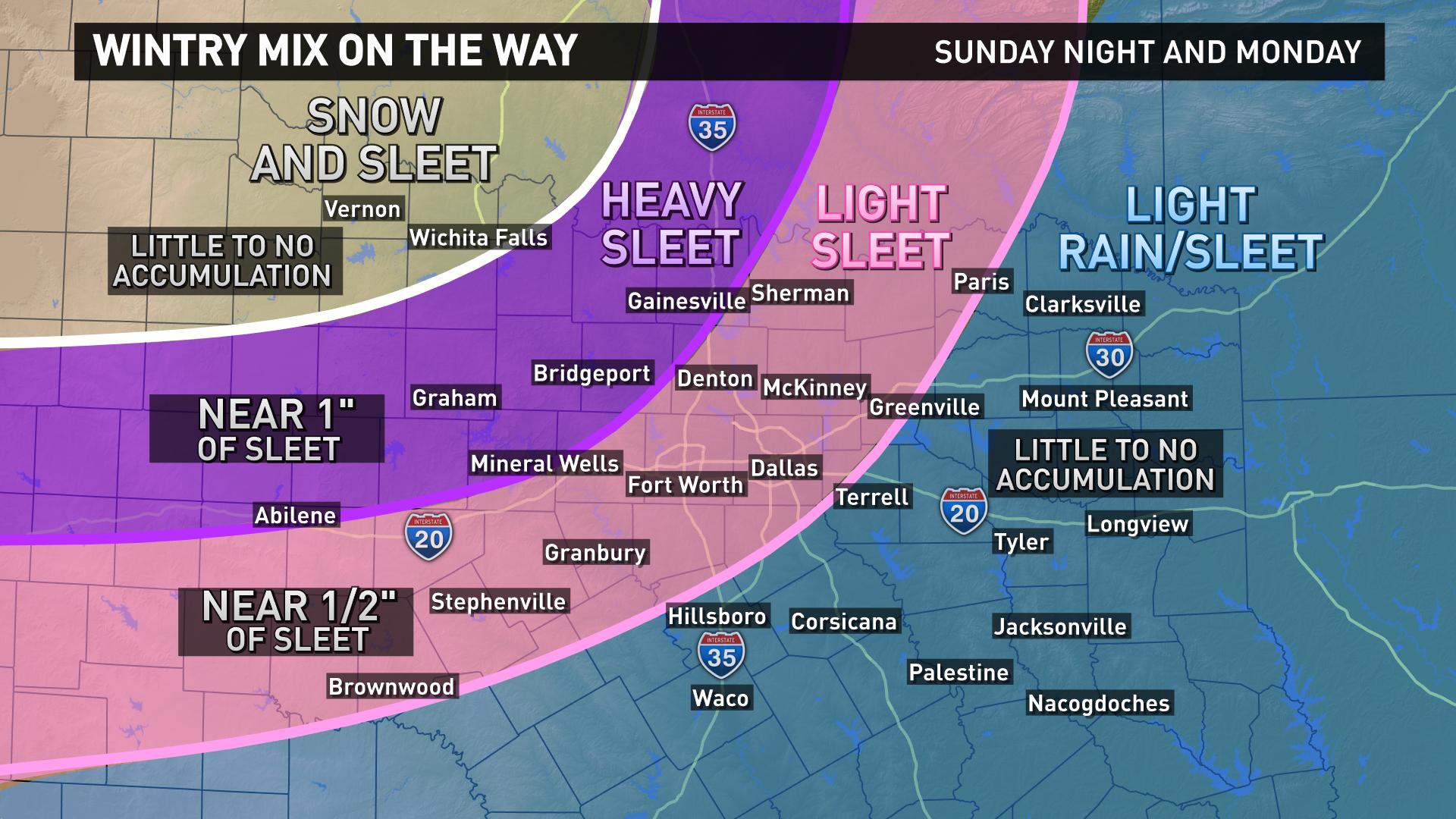
Although it has been a pleasant Saturday afternoon across north Texas, the verdict is in, and all seem to agree: The Ice Storm Cometh!
A COLD RAIN should begin moving into the Metroplex after 9 AM Sunday with temperatures near 40 degrees, becoming widespread (100% coverage) during the day as temperatures fall into the mid 30s by sunset. Sleet and snow will begin to fall well NW of the Metroplex by late in the day, but should evolve into all sleet for the remainder of this event. Significant snow accumulations will be mainly in Oklahoma but with some light accumulations possible along Red River Counties, but even there, it should be mostly sleet.
Precipitation intensity will DECREASE RAPIDLY Sunday evening as temperatures continue to fall, and most of the Metroplex should be below freezing by 9 PM.
A wave of sleet and embedded areas of THUNDERSLEET (i.e., thunderstorms with moderate to heavy sleet) will push in from the west during the predawn hours of Monday and will overspread ALL of the area during the day Monday. Sleet accumulations will range from 0.25" to 1.25" across the Metroplex with heavier amounts possible where the embedded thundersleet actually occurs. The sleet may mix with freezing rain at times with up to a tenth of an inch of ice on top of the sleet.
Temperatures will NOT get above freezing on Monday. In fact they will likely remain below freezing until Tuesday afternoon. This will be a hard freeze for the area so the ice will become encrusted into the streets making for a very bumpy - not to mention slick - ride by Monday afternoon and continuing into Tuesday midday.
Make your preparations during the next 24 hours or so....it will not be very pleasant come Monday!
EDIT: For our friends in Oklahoma and the Wichita Falls area ... The NWS in Oklahoma City has not yet issued anything for southern Oklahoma and parts of NW Texas, but it is likely they will soon. So just because you do not see anything in these areas on this map, that does not mean this area will be missed!
0 likes
Re: Re:
gboudx wrote:
From McCauleys latest update, he's not suggesting only light sleet.
He used a phrased earlier this winter I'd like to bring back! Entomb the metroplex in ice, no one goes anywhere.
0 likes
The above post and any post by Ntxw is NOT an official forecast and should not be used as such. It is just the opinion of the poster and may or may not be backed by sound meteorological data. It is NOT endorsed by any professional institution including Storm2k. For official information, please refer to NWS products.
Help support Storm2K!
Help support Storm2K!
-
Ralph's Weather
- S2K Supporter
- Posts: 3371
- Age: 38
- Joined: Fri Dec 13, 2013 11:55 am
- Location: Lindale, TX
- Contact:
Re: Texas Winter 2014-2015
ludosc wrote:here's the graphic Delkus/WFAA tweeted out about 45 minutes ago
http://pbs.twimg.com/media/B-aKJcUCYAAwO3R.jpg:large
Wow that map id's terrible for NE TX considering we will likely see similar our worse conditions than the Metroplex.
0 likes
Follow on Facebook at Ralph's Weather.
-
Yukon Cornelius
- S2K Supporter
- Posts: 1834
- Age: 42
- Joined: Thu Dec 20, 2012 9:23 pm
- Location: Dean, TX/Westcliffe, CO
Re: Texas Winter 2014-2015
So after looking at that map, Wichita county is forecasted to get little to no accumulation after hearing for the last two days about numerous inches? North and South of us is suppose to get accumulations but not here? I don't understand, we have forecasted 60-70% chance of mostly snow and some sleet mix for two days and one night but no accumulations?
0 likes
#neversummer
-
weatherguy425
- Tropical Storm

- Posts: 180
- Joined: Sun Aug 16, 2009 1:06 pm
- Location: Houston, TX > Lubbock, TX > Savannah, GA
- Contact:
Re: Texas Winter 2014-2015
When viewing these maps from network affiliates, take specifics with a grain of salt. They are likely made by a weather producer, forecaster, or meteorologist simply drawing polygons onto a map. Also, the forecast is going to revolve around their viewing area. Outlying areas may be left out, or it may 'appear' that they are not forecasting anything for that area.
0 likes


Re: Texas Winter 2014-2015
Yukon Cornelius wrote:So after looking at that map, Wichita county is forecasted to get little to no accumulation after hearing for the last two days about numerous inches? North and South of us is suppose to get accumulations but not here? I don't understand
I haven't been following your weather up there, but I have and will comment again about those silly maps you see on the news. It's just to make it simple for the average viewer. People don't like to read or listen to words. They need to see some bright and colorful photo, so that's why they create these useless maps.
The maps you hear your coworkers complaining about all the time, "Yeah, man. I was watching that ol' Pete on channel 8 the other night. Had us just below the cutoff line on the map, but when I woke up this morning, there was three inches of snow on the ground! They can never get anything right. They just guessing...that's all they doing. I could do their job."
0 likes
-
Yukon Cornelius
- S2K Supporter
- Posts: 1834
- Age: 42
- Joined: Thu Dec 20, 2012 9:23 pm
- Location: Dean, TX/Westcliffe, CO
Re: Texas Winter 2014-2015
weatherguy425 wrote:When viewing these maps from network affiliates, take specifics with a grain of salt. They are likely made by a weather producer, forecaster, or meteorologist simply drawing polygons onto a map. Also, the forecast is going to revolve around their viewing area. Outlying areas may be left out, or it may 'appear' that they are not forecasting anything for that area.
Thanks. I was curious as I have family traveling into the area Monday...hopefully.
0 likes
#neversummer
Re: Texas Winter 2014-2015
Yukon Cornelius wrote:So after looking at that map, Wichita county is forecasted to get little to no accumulation after hearing for the last two days about numerous inches? North and South of us is suppose to get accumulations but not here? I don't understand, we have forecasted 60-70% chance of mostly snow and some sleet mix for two days and one night but no accumulations?
Don't worry too much about maps. As far as I know every model has snow and sleet falling in Wichita Falls from tomorrow night through Tuesday some several inches predominantly snow. Probably another big snowstorm up your way later this week as well.
0 likes
The above post and any post by Ntxw is NOT an official forecast and should not be used as such. It is just the opinion of the poster and may or may not be backed by sound meteorological data. It is NOT endorsed by any professional institution including Storm2k. For official information, please refer to NWS products.
Help support Storm2K!
Help support Storm2K!
-
Yukon Cornelius
- S2K Supporter
- Posts: 1834
- Age: 42
- Joined: Thu Dec 20, 2012 9:23 pm
- Location: Dean, TX/Westcliffe, CO
Re: Texas Winter 2014-2015
iorange55 wrote:Yukon Cornelius wrote:So after looking at that map, Wichita county is forecasted to get little to no accumulation after hearing for the last two days about numerous inches? North and South of us is suppose to get accumulations but not here? I don't understand
I haven't been following your weather up there, but I have and will comment again about those silly maps you see on the news. It's just to make it simple for the average viewer. People don't like to read or listen to words. They need to see some bright and colorful photo, so that's why they create these useless maps.
The maps you hear your coworkers complaining about all the time, "Yeah, man. I was watching that ol' Pete on channel 8 the other night. Had us just below the cutoff line on the map, but when I woke up this morning, there was three inches of snow on the ground! They can never get anything right. They just guessing...that's all they doing. I could do their job."
Yeah, you are exactly right about that and that sounds exactly like my coworkers! I try to talk about actual weather statistics and the things I read about on here and get shot down because I'm not a meteorologist on the news...
0 likes
#neversummer
-
Yukon Cornelius
- S2K Supporter
- Posts: 1834
- Age: 42
- Joined: Thu Dec 20, 2012 9:23 pm
- Location: Dean, TX/Westcliffe, CO
Re: Texas Winter 2014-2015
Ntxw wrote:Yukon Cornelius wrote:So after looking at that map, Wichita county is forecasted to get little to no accumulation after hearing for the last two days about numerous inches? North and South of us is suppose to get accumulations but not here? I don't understand, we have forecasted 60-70% chance of mostly snow and some sleet mix for two days and one night but no accumulations?
Don't worry too much about maps. As far as I know every model has snow and sleet falling in Wichita Falls from tomorrow night through Tuesday some several inches predominantly snow. Probably another big snowstorm up your way later this week as well.
Thanks! I usually don't pay any attention to them but with the lack of any advisory, watch, or warning being issued I was wondering if I had totally missed something.
0 likes
#neversummer
Who is online
Users browsing this forum: No registered users and 83 guests