Texas Winter 2014-2015
Moderator: S2k Moderators
Forum rules
 The posts in this forum are NOT official forecast and should not be used as such. They are just the opinion of the poster and may or may not be backed by sound meteorological data. They are NOT endorsed by any professional institution or STORM2K.

The posts in this forum are NOT official forecast and should not be used as such. They are just the opinion of the poster and may or may not be backed by sound meteorological data. They are NOT endorsed by any professional institution or STORM2K.
-
Brent
- S2K Supporter

- Posts: 38708
- Age: 37
- Joined: Sun May 16, 2004 10:30 pm
- Location: Tulsa Oklahoma
- Contact:
Re: Texas Winter 2014-2015
It's 32 here... if this starts as rain it will be freezing rain!
0 likes
#neversummer
-
Ralph's Weather
- S2K Supporter
- Posts: 3371
- Age: 38
- Joined: Fri Dec 13, 2013 11:55 am
- Location: Lindale, TX
- Contact:
Here is my forecast map for tomorrow. Yes, it is about double the NWS forecast and I have outlined in previous posts why I am thinking what is shown in my forecast.
Edit to better represent that the high end totals are going to be isolated.
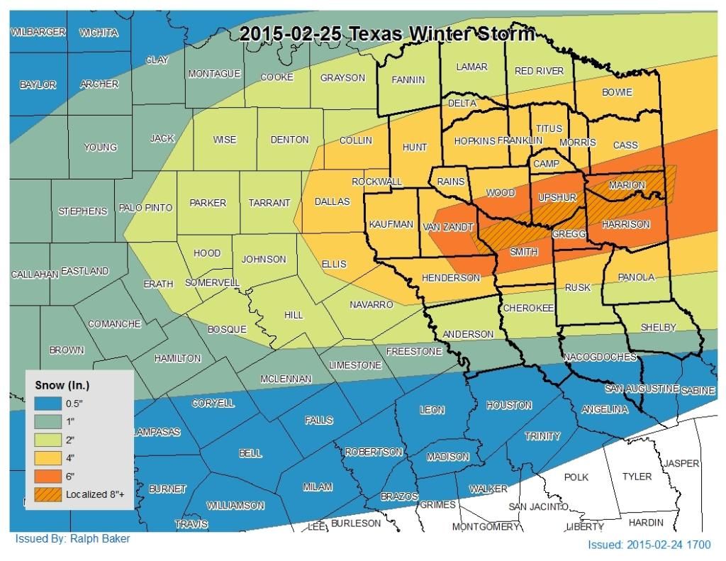
Edit to better represent that the high end totals are going to be isolated.

Last edited by Ralph's Weather on Tue Feb 24, 2015 5:59 pm, edited 1 time in total.
0 likes
Follow on Facebook at Ralph's Weather.
-
Brandon8181
- S2K Supporter
- Posts: 431
- Age: 42
- Joined: Tue Jan 04, 2011 4:52 pm
- Location: Tyler, TX
- Contact:
Re:
Ralph's Weather wrote:Here is my forecast map for tomorrow. Yes, it is about double the NWS forecast and I have outlined in previous posts why I am thinking what is shown in my forecast.

I think Ralph is being slightly...biased to his own preferences... considering HE LIVES IN THE RED AREA.....
Just saying
Can you provide a little more information on what your thoughts are that helped you put that snowfall output together?
0 likes
I am not a meteorologist. Any post from me should be taken as hobby or fun educational information, but not an accurate source for weather information. Please, refer to your local weather station or National Weather Service for the most up to date information. 
-
Lagreeneyes03
- Category 2

- Posts: 607
- Joined: Mon Dec 09, 2013 10:53 am
- Location: Luxurious Lake Grapevine
Re:
TheProfessor wrote:SREF continues to get wetter and snowier for DFW, it also has Friday's high at 28 degrees.
It's funny the difference between the TV folks and the short range models. Channel 8 went from 2-4 to 1-3 for the metro. Have a feeling that alot of no school decisions will be made in the AM.
0 likes
I'm a Princess, not a forecaster.
-
gboudx

- S2K Supporter
- Posts: 4090
- Joined: Thu Sep 04, 2003 1:39 pm
- Location: Rockwall, Tx but from Harvey, La
Update from jeff:
Winter Weather Advisory in effect from 300am to 900am Wednesday for snow/sleet for Trinity, Houston and Madison Counties.
Upper level trough will move across the region tonight and early Wednesday with warm layer aloft gradually cooling to below freezing. Strong lift will come to bear across the region late tonight generating light rain and drizzle over much of the area. High resolution forecast models show a band of slightly heavier banded precipitation over our northern counties Wednesday morning. Temperatures in the “snow growth” level will be near or falling to below freezing near/at the time of maximum lift which supports a change of light rain to light sleet/light snow.
Most favored area for a mix of winter precipitation of rain/sleet/snow or change to sleet and snow will be from Madisonville to Crockett to Trinity. Surface temperatures are expected to range from 32-34 across this region Wednesday morning suggesting much of what falls will melt on contact with the ground. However any higher sleet/snow rates in the banded precipitation may result in a quick ½ to 1 inch of accumulation on rooftops, grassy areas, and elevated objects.
Further south from College Station to Huntsville to Livingston rain may mix with sleet and snow, but do not expect a full changeover given a less favorable freezing profile aloft.
Metro Houston area should remain all rain, but cannot rule out a sleet pellet or snow grain mixing with the rain. Temperatures will be in the middle to upper 30’s resulting in any frozen precipitation melting on contact with the ground.
Thursday looks by far the best day of the week…and it will be far from great with partly cloudy skies and continued cold temperatures. Another arctic front blasts through the area Thursday night with cold air advection in place on Friday resulting in another cold day with increasing clouds and highs likely in the 40’s. Models have been trending colder behind this front and yet again another storm system will approach from the SW US. Will keep all precipitation liquid for now in the Friday night/Saturday time period and watch temperatures trends very closely over the next 48 hours. Could see freezing/frozen precipitation over parts of C TX/N TX yet again Friday into Saturday and freezing temperatures over portions of SE TX Friday night and Saturday morning. Precipitation chances at the moment during the critical temperature period look to only be in the 20-30% range.
0 likes
-
Brent
- S2K Supporter
- Posts: 38708
- Age: 37
- Joined: Sun May 16, 2004 10:30 pm
- Location: Tulsa Oklahoma
- Contact:
Re: Re:
Lagreeneyes03 wrote:TheProfessor wrote:SREF continues to get wetter and snowier for DFW, it also has Friday's high at 28 degrees.
It's funny the difference between the TV folks and the short range models. Channel 8 went from 2-4 to 1-3 for the metro. Have a feeling that alot of no school decisions will be made in the AM.
I got a feeling there's gonna be a lot of surprises... I mean temps are plenty cold already.
0 likes
#neversummer
Re: Re:
Lagreeneyes03 wrote:TheProfessor wrote:SREF continues to get wetter and snowier for DFW, it also has Friday's high at 28 degrees.
It's funny the difference between the TV folks and the short range models. Channel 8 went from 2-4 to 1-3 for the metro. Have a feeling that alot of no school decisions will be made in the AM.
Yep. CBS11 just did the same thing. 1-2 inches for our area. I remember this, and I am not saying this will happen, but the Feb 2010 snowstorm started out as 1-2 inches. That total was surpassed by 7 in the morning on the way to a foot.
0 likes
-
Wthrlvrmom
- Tropical Low

- Posts: 35
- Age: 40
- Joined: Tue Jan 28, 2014 1:50 pm
- Location: Near Azle, TX


-
Brandon8181
- S2K Supporter
- Posts: 431
- Age: 42
- Joined: Tue Jan 04, 2011 4:52 pm
- Location: Tyler, TX
- Contact:
Re: Re:
gpsnowman wrote:Lagreeneyes03 wrote:TheProfessor wrote:SREF continues to get wetter and snowier for DFW, it also has Friday's high at 28 degrees.
It's funny the difference between the TV folks and the short range models. Channel 8 went from 2-4 to 1-3 for the metro. Have a feeling that alot of no school decisions will be made in the AM.
Yep. CBS11 just did the same thing. 1-2 inches for our area. I remember this, and I am not saying this will happen, but the Feb 2010 snowstorm started out as 1-2 inches. That total was surpassed by 7 in the morning on the way to a foot.
gpsnowman.. I remember the exact same thing... I lived in Sherman at the time..it was prior to my family moving to Tyler. They were only forecasted 3 inches or so if I remember right and I think we got close to a foot of snow. I believe we were snowed in for about a week or so, and all of the schools were out. It was pretty bad.
The interesting thing..is it was the exact same situation as we are dealing with here.
0 likes
I am not a meteorologist. Any post from me should be taken as hobby or fun educational information, but not an accurate source for weather information. Please, refer to your local weather station or National Weather Service for the most up to date information.
-
Brandon8181
- S2K Supporter
- Posts: 431
- Age: 42
- Joined: Tue Jan 04, 2011 4:52 pm
- Location: Tyler, TX
- Contact:
Re: Texas Winter 2014-2015
iorange55 wrote:Quick snowfall prediction map I just made...
Love it...
0 likes
I am not a meteorologist. Any post from me should be taken as hobby or fun educational information, but not an accurate source for weather information. Please, refer to your local weather station or National Weather Service for the most up to date information.
Re: Texas Winter 2014-2015
iorange55 wrote:Quick snowfall prediction map I just made...
Best map I've seen all day. I am in the red dot!!!
0 likes
-
South Texas Storms

- Professional-Met

- Posts: 4255
- Joined: Thu Jun 24, 2010 12:28 am
- Location: Houston, TX
Re: Texas Winter 2014-2015
The latest HRRR and RAP models are showing several inches of snow in DFW with a 6 inch bulls-eye just northwest of there with snow still falling when the run ends tomorrow morning. The model simulated radar reflectivity shows some heavy snowfall bands moving east across north Texas with this system.
Porta and us in central Texas will unfortunately miss out again. Enjoy it you lucky folks in north Texas!
Porta and us in central Texas will unfortunately miss out again. Enjoy it you lucky folks in north Texas!
0 likes
-
Ralph's Weather
- S2K Supporter
- Posts: 3371
- Age: 38
- Joined: Fri Dec 13, 2013 11:55 am
- Location: Lindale, TX
- Contact:
Re: Re:
Brandon8181 wrote:Ralph's Weather wrote:Here is my forecast map for tomorrow. Yes, it is about double the NWS forecast and I have outlined in previous posts why I am thinking what is shown in my forecast.
I think Ralph is being slightly...biased to his own preferences... considering HE LIVES IN THE RED AREA.....
Just sayinglol
Can you provide a little more information on what your thoughts are that helped you put that snowfall output together?
I guess I should have included my note that the Red area is to cover the isolated top end totals. On my FB post I put a note in to emphasize that I have updated my map to show that. So I will edit my post to show my updated map.
I expect temps to be in the 30-32 range so ratios should be 8-10:1 and QPF totals to be 0.5" with up to an inch under the heavy bands over NE TX. Whoever gets the heavy band will get hammered.
0 likes
Follow on Facebook at Ralph's Weather.
-
TheProfessor

- Professional-Met
- Posts: 3506
- Age: 29
- Joined: Tue Dec 03, 2013 10:56 am
- Location: Wichita, Kansas
Re: Texas Winter 2014-2015
My snow fall map! 


0 likes
An alumnus of The Ohio State University.
Your local National Weather Service office is your best source for weather information.
Your local National Weather Service office is your best source for weather information.
-
Ralph's Weather
- S2K Supporter
- Posts: 3371
- Age: 38
- Joined: Fri Dec 13, 2013 11:55 am
- Location: Lindale, TX
- Contact:
Re: Texas Winter 2014-2015
TheProfessor wrote:My snow fall map!
Great use of Fill lol. Hope not too many people are disappointed by this storm, but some will be ecstatic.
0 likes
Follow on Facebook at Ralph's Weather.
-
Tcu101

- Tropical Storm

- Posts: 174
- Age: 53
- Joined: Wed Jan 29, 2014 6:57 pm
- Location: W Fort Worth/ Benbrook
- Contact:
Re: Texas Winter 2014-2015
TheProfessor wrote:My snow fall map!
For meaness you could have put a donut hole around Austin
0 likes
Personal Forecast Disclaimer:
The posts in this forum are NOT official forecast and should not be used as such. They are just the opinion of the poster and may or may not be backed by sound meteorological data. They are NOT endorsed by any professional institution or storm2k.org. For official information, please refer to the NHC and NWS products.
The posts in this forum are NOT official forecast and should not be used as such. They are just the opinion of the poster and may or may not be backed by sound meteorological data. They are NOT endorsed by any professional institution or storm2k.org. For official information, please refer to the NHC and NWS products.
Re: Texas Winter 2014-2015
TheProfessor wrote:My snow fall map!
Professor, you have learned a lot since you stared here on the forum, a lot more than I have. But your handwriting is awful.
Last edited by gpsnowman on Tue Feb 24, 2015 6:07 pm, edited 1 time in total.
0 likes
Who is online
Users browsing this forum: Stratton23 and 45 guests