Texas Spring-2015

U.S. & Caribbean Weather Discussions and Severe Weather Events

Moderator: S2k Moderators

Forum rules

The posts in this forum are NOT official forecast and should not be used as such. They are just the opinion of the poster and may or may not be backed by sound meteorological data. They are NOT endorsed by any professional institution or STORM2K.

Help Support Storm2K
Message
Author
weatherdude1108
Category 5
Category 5
Posts: 4228
Joined: Tue Dec 13, 2011 1:04 pm
Location: Northwest Austin/Cedar Park, TX

Re:

#341 Postby weatherdude1108 » Fri Apr 17, 2015 5:37 pm

gboudx wrote:weatherdude, the radar trend sure looks like your friend for ATX area. Huge shield riding up 35, and it looks like good storms west of Austin which is where I think most of the watershed is for your lakes.


Looks like the Austin bubble shield has burst!

It is raining moderately now! The Highland Lakes getting a nice watering. Woohoo! :)

The radar trend is my friend. :cheesy:
0 likes   

User avatar
Ntxw
Storm2k Moderator
Storm2k Moderator
Posts: 22784
Joined: Wed Oct 21, 2009 6:34 pm
Location: DFW, Texas

#342 Postby Ntxw » Fri Apr 17, 2015 6:36 pm

Finally, daytime storms that congeal into MCS...about time

Image
0 likes   
The above post and any post by Ntxw is NOT an official forecast and should not be used as such. It is just the opinion of the poster and may or may not be backed by sound meteorological data. It is NOT endorsed by any professional institution including Storm2k. For official information, please refer to NWS products.

  Help support Storm2K!
Help Support Storm2K

Brent
S2K Supporter
S2K Supporter
Posts: 38088
Age: 36
Joined: Sun May 16, 2004 10:30 pm
Location: Tulsa Oklahoma
Contact:

Re: Texas Spring-2015

#343 Postby Brent » Fri Apr 17, 2015 6:59 pm

000
NWUS54 KFWD 172347
LSRFWD
PRELIMINARY LOCAL STORM REPORT
NATIONAL WEATHER SERVICE FORT WORTH TX
646 PM CDT FRI APR 17 2015
..TIME... ...EVENT... ...CITY LOCATION... ...LAT.LON...
..DATE... ....MAG.... ..COUNTY LOCATION..ST.. ...SOURCE....
..REMARKS..
0640 PM TSTM WND GST 8 W CROWLEY 32.58N 97.46W
04/17/2015 M67 MPH TARRANT TX TRAINED SPOTTER
SPOTTER MEASURED A 67 MPH WIND GUST 8 MILES WEST
OF CROWLEY.
0 likes   
#neversummer

User avatar
Rgv20
S2K Supporter
S2K Supporter
Posts: 2466
Age: 38
Joined: Wed Jan 05, 2011 5:42 pm
Location: Edinburg/McAllen Tx

#344 Postby Rgv20 » Fri Apr 17, 2015 7:24 pm

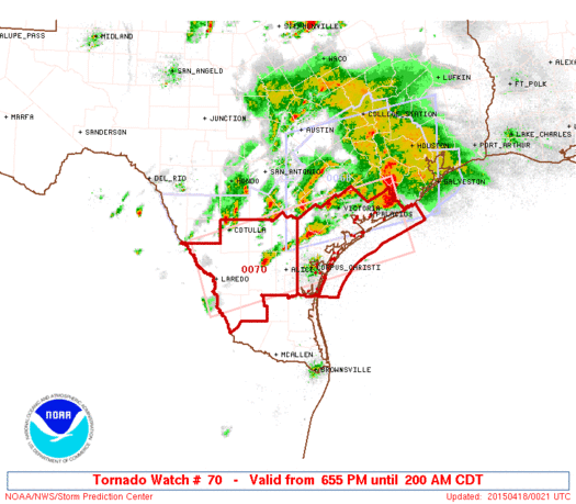
A rare Tornado Watch issued for South Texas :eek:

Image


URGENT - IMMEDIATE BROADCAST REQUESTED
TORNADO WATCH NUMBER 70
NWS STORM PREDICTION CENTER NORMAN OK
655 PM CDT FRI APR 17 2015

THE NWS STORM PREDICTION CENTER HAS ISSUED A

* TORNADO WATCH FOR PORTIONS OF
SOUTH TEXAS AND THE MIDDLE TEXAS COASTAL PLAIN
COASTAL WATERS

* EFFECTIVE THIS FRIDAY NIGHT AND SATURDAY MORNING FROM 655 PM
UNTIL 200 AM CDT.

* PRIMARY THREATS INCLUDE...
A COUPLE TORNADOES POSSIBLE
SCATTERED DAMAGING WINDS AND ISOLATED SIGNIFICANT GUSTS TO 75
MPH POSSIBLE
ISOLATED VERY LARGE HAIL EVENTS TO 2 INCHES IN DIAMETER POSSIBLE

SUMMARY...SCATTERED SEVERE THUNDERSTORMS EXPECTED TO PERSIST THROUGH
LATE TONIGHT ALONG A ROUGHLY WEST-EAST AXIS ACROSS PARTS OF SOUTH
TEXAS...POSING PERIODIC THREATS FOR LARGE HAIL...HIGH WIND...AND A
COUPLE TORNADOES.

THE TORNADO WATCH AREA IS APPROXIMATELY ALONG AND 50 STATUTE
MILES EITHER SIDE OF A LINE FROM 20 MILES WEST OF LAREDO TEXAS TO
40 MILES EAST OF PALACIOS TEXAS. FOR A COMPLETE DEPICTION OF THE
WATCH SEE THE ASSOCIATED WATCH OUTLINE UPDATE (WOUS64 KWNS WOU0).

PRECAUTIONARY/PREPAREDNESS ACTIONS...

REMEMBER...A TORNADO WATCH MEANS CONDITIONS ARE FAVORABLE FOR
TORNADOES AND SEVERE THUNDERSTORMS IN AND CLOSE TO THE WATCH
AREA. PERSONS IN THESE AREAS SHOULD BE ON THE LOOKOUT FOR
THREATENING WEATHER CONDITIONS AND LISTEN FOR LATER STATEMENTS
AND POSSIBLE WARNINGS.

&&

OTHER WATCH INFORMATION...CONTINUE...WW 67...WW 68...WW 69...

AVIATION...TORNADOES AND A FEW SEVERE THUNDERSTORMS WITH HAIL
SURFACE AND ALOFT TO 2 INCHES. EXTREME TURBULENCE AND SURFACE
WIND GUSTS TO 65 KNOTS. A FEW CUMULONIMBI WITH MAXIMUM TOPS TO
550. MEAN STORM MOTION VECTOR 26025.


...CORFIDI
0 likes   
The following post is NOT an official forecast and should not be used as such. It is just the opinion of the poster and may or may not be backed by sound meteorological data. It is NOT endorsed by any professional institution including storm2k.org For Official Information please refer to the NHC and NWS products.

User avatar
Rgv20
S2K Supporter
S2K Supporter
Posts: 2466
Age: 38
Joined: Wed Jan 05, 2011 5:42 pm
Location: Edinburg/McAllen Tx

#345 Postby Rgv20 » Fri Apr 17, 2015 7:29 pm

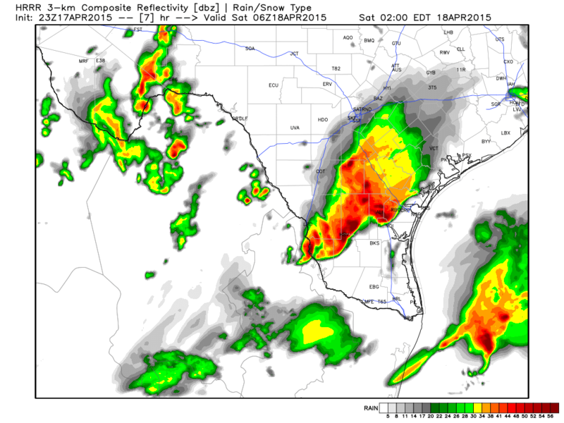
Lets see how well the latest HRRR Forecast verifies....the image below is a simulated radar forecast for just after midnight.

Map Courtesy of Weatherbell..
Image
0 likes   
The following post is NOT an official forecast and should not be used as such. It is just the opinion of the poster and may or may not be backed by sound meteorological data. It is NOT endorsed by any professional institution including storm2k.org For Official Information please refer to the NHC and NWS products.

User avatar
TeamPlayersBlue
Category 5
Category 5
Posts: 3445
Joined: Tue Feb 02, 2010 1:44 am
Location: Denver/Applewood, CO

#346 Postby TeamPlayersBlue » Fri Apr 17, 2015 8:43 pm

That storm that just passed thrugh SW Houston was a NASTY one. Unreal lightening and thunder. Absolutely dumping.
0 likes   
Personal Forecast Disclaimer:
The posts in this forum are NOT official forecast and should not be used as such. They are just the opinion of the poster and may or may not be backed by sound meteorological data. They are NOT endorsed by any professional institution or storm2k.org. For official information, please refer to the NHC and NWS products.

User avatar
vbhoutex
Storm2k Executive
Storm2k Executive
Posts: 29112
Age: 73
Joined: Wed Oct 09, 2002 11:31 pm
Location: Cypress, TX
Contact:

Re: Texas Spring-2015

#347 Postby vbhoutex » Fri Apr 17, 2015 9:30 pm

We have had another round of severe weather in Houston. Hail to 2", winds to 75 mph with numerous trees down and ongoing flash flooding. I have friends in the Angleton area(S) who lost windows, gutters and fence to the winds and hail. I have been lucky where I live on the West side with just a lot of rain and lightning and thunder. Some areas have had rainfall rates up to 2.5-3" per half hour. Many areas also reporting power outages especially between Houston and Galveston.
To top it off there are 3 more lines of "storms" between Houston and San Antonio. Hopefully they will at least be weaker than what we just had/are having.
0 likes   
Skywarn, C.E.R.T.
Please click below to donate to STORM2K to help with the expenses of keeping the site going:
Image

Brent
S2K Supporter
S2K Supporter
Posts: 38088
Age: 36
Joined: Sun May 16, 2004 10:30 pm
Location: Tulsa Oklahoma
Contact:

Re: Texas Spring-2015

#348 Postby Brent » Fri Apr 17, 2015 9:35 pm

It's finally storming in DFW. It's a miracle!
0 likes   
#neversummer

weatherdude1108
Category 5
Category 5
Posts: 4228
Joined: Tue Dec 13, 2011 1:04 pm
Location: Northwest Austin/Cedar Park, TX

#349 Postby weatherdude1108 » Fri Apr 17, 2015 10:22 pm

0.9 of an inch at the Weatherdude casa today. Most rain I have had in about a month. :)
0 likes   

Shoshana
Category 5
Category 5
Posts: 1414
Joined: Thu Sep 09, 2004 7:50 pm
Location: NE Austin

Re:

#350 Postby Shoshana » Sat Apr 18, 2015 12:02 am

weatherdude1108 wrote:0.9 of an inch at the Weatherdude casa today. Most rain I have had in about a month. :)


I don't think that we got that much here, will check in the morning...
0 likes   

ronyan
S2K Supporter
S2K Supporter
Posts: 791
Age: 39
Joined: Tue Sep 09, 2008 5:46 pm
Location: Lake Jackson, TX

Re: Texas Spring-2015

#351 Postby ronyan » Sat Apr 18, 2015 7:51 am

Significant tree damage and downed power lines still have some in the dark here in Lake Jackson. Winds gusted to 72 mph and 2 inches of rain fell in 30 minutes (maximum rainfall rate 5.88 in/hr), along with some hail 1"+ just to the North of us in Angleton. About to go survey the damage further but this is one of the worst non-tropical events we've had here.
0 likes   

User avatar
dhweather
S2K Supporter
S2K Supporter
Posts: 6199
Joined: Sat Aug 14, 2004 9:29 pm
Location: Heath, TX
Contact:

#352 Postby dhweather » Sat Apr 18, 2015 9:09 am

1.22" of liquid gold in Heath - that was nice! Can't wait to see if all that got into the lakes.
0 likes   
The above post and any post by dhweather is NOT an official forecast and should not be used as such. It is just the opinion of the poster and may or may not be backed by sound meteorological data. It is NOT endorsed by any professional institution including storm2k.org. For official information, please refer to NWS products.

User avatar
CentralTxAggie
Tropical Depression
Tropical Depression
Posts: 63
Joined: Fri Feb 07, 2014 11:03 am
Location: TX

Re:

#353 Postby CentralTxAggie » Sat Apr 18, 2015 9:56 am

weatherdude1108 wrote:0.9 of an inch at the Weatherdude casa today. Most rain I have had in about a month. :)


.6 down here in South Austin.
0 likes   
No forecasts from this lurker, but I will tell you what is going on outside my window. :)

User avatar
TheAustinMan
Category 5
Category 5
Posts: 1047
Age: 25
Joined: Mon Jul 08, 2013 4:26 pm
Location: United States
Contact:

Re: Texas Spring-2015

#354 Postby TheAustinMan » Sat Apr 18, 2015 10:11 am

Rainfall totals in Central Texas from Thursday and Friday. Edwards Aquifer outlined in black.

Image
Source: NWS Austin/San Antonio
0 likes   
ImageImageImage
Treat my opinions with a grain of salt. For official information see your local weather service.

User avatar
Ntxw
Storm2k Moderator
Storm2k Moderator
Posts: 22784
Joined: Wed Oct 21, 2009 6:34 pm
Location: DFW, Texas

#355 Postby Ntxw » Sat Apr 18, 2015 11:30 am

As of this post all 4 of the major Texas metropolitan areas are still above normal rainfall for the year including amounts from yesterday. Far East Texas and the areas from Houston-Tyler-Texarkana are much above average some places 5-8 inches above normal.

Lake Lavon continues to see some of the more dramatic increases in the span of 2-3 months from less than 50% now to 85% rising almost 10FT in a relatively short amount of time considering.
0 likes   
The above post and any post by Ntxw is NOT an official forecast and should not be used as such. It is just the opinion of the poster and may or may not be backed by sound meteorological data. It is NOT endorsed by any professional institution including Storm2k. For official information, please refer to NWS products.


  Help support Storm2K!

Help Support Storm2K


User avatar
vbhoutex
Storm2k Executive
Storm2k Executive
Posts: 29112
Age: 73
Joined: Wed Oct 09, 2002 11:31 pm
Location: Cypress, TX
Contact:

Re: Texas Spring-2015

#356 Postby vbhoutex » Sat Apr 18, 2015 3:42 pm

Jeff's storm report from last night:
A rough day across SE TX on Friday with a large long lived destructive bow echo moving from south of San Antonio to Galveston Island in about 6 hours and then all the way to SC Louisiana. Widespread wind damage and power outages especially across southern Fort Bend, southern Harris, and Brazoria Counties. Intense meso low formed over SW Fort Bend County helping to bow out the leading edge line into Brazoria County. Radar reflectivity was nearly 65dbz over western and central Brazoria County indicating very large hail. Hobby Airport tower radar was recording inbound radial velocities above the surface or 90-100mph. Town of Angleton, TX was especially hard hit with tennis ball size hail driven by sustained winds near 75mph…resulting in extensive damage. Meso low intensified over southern Harris County resulting in incredible rainfall rates and rapid flash flooding. This was one of the most intense bow echoes I have ever worked in SE TX with radar velocities frequently pegging 100mph along its 6 hour track….such events are more common over the central plains, Midwest and northern plains in the summer months. However the last 48 hours have produced a large long track tornadic supercell on Thursday afternoon and then the bow echo yesterday afternoon.

As of 1000am this morning there are still over 40,000 residents without power over Brazoria, southern Harris, Fort Bend, and Galveston Counties…the areas hard hit with the bow echo. Power has been out at some locations for over 14 hours.

Note: At one point last evening the National Lightning Detection Network was recording over 6500 strikes in 10 minutes over SE TX.


Morales, Jackson: trees down…est winds 50-60mph

10W Bay City, Matagorda: tornado touchdown along leading edge gust front

Stafford, Fort Bend: wind damage (possible tornado) near Stafford Center

Angleton, Brazoria: bow echo (winds 75-80mph) for 10-15 minutes. Egg to tennis ball size hail. Extensive damage to homes…many westward facing windows shattered, roofs damaged, trees and power lines down. Damage widespread across much of the city. Circus tent collapsed due to wind.

Danbury, Brazoria: 2.0 in diameter hail with 70mph winds. Numerous trees down and hail damage to vehicles on SH 288.

Iowa Colony, Brazoria: 72mph wind with bow echo

Katy, Harris: 2 homes struck by lightning.

Jamaica Beach, Galveston: Est 80mph with bow echo. Extensive damage to homes. Entire roof blow off one home.

Hobby Airport, Harris: HOU tower recorded 53kts (61mph) with bow echo.

Nassau Bay, Harris: EST 60-65mph winds with bow echo. Numerous large trees down blocking streets. Some trees fell onto homes.

Friendswood, Galveston: Sustained 40-55mph winds with gust to 60mph with bow echo. Tree limbs down…power outages

Pasadena, Harris: Flash Flood: many city streets covered with water…water almost into homes

Bellaire, Harris: Flash Flood: numerous cars stalled in high water…up to and over hoods of cars

Stafford, Fort Bend: Flash Flood: several high water rescues along US 59 feeder roads near Beltway 8

La Porte, Harris: Major house flooding, 65 homes flooded

La Porte, Harris: 30-min rainfall rate of 3.62 inches 500-yr rainfall frequency

Houston, Harris: house flooding reported near 610 and Brays Bayou

Houston, Harris: water 6 ft deep on W Bellfort N of US 59. Keegans Bayou overflowing

Houston, Harris: all mainlanes US 59 closed by flooding at Spur 527

Friendswood, Galveston: Flash Flood: numerous streets flooded and impassable

South Houston, Harris: I-45 feeder roads impassable near 610 Loop. All roadways into Hobby Airport flooded and impassable. HFD conducted several water rescues

Webster, Harris: Subdivision streets 3-5 feet deep with water

Houston, Harris: HFD responding to over 40 request to high water rescue…emergency responders have hard time getting through flood waters.

Morgans Point, Harris: 41mph marine wind gust recorded

Buoy 30 miles E of Galveston: 59mph wind gust form bow echo


Friday Rainfall:

Richmond: 4.64

NRG Stadium: 5.20

Sugar Land: 4.20

Pecan Grove: 3.08

Needville: 4.0

Pearland: 4.35

Westbury: 4.14

Wharton: 4.19

Ganado: 4.06

Pasadena: 4.92

Friendswood: 4.04

Deer Park: 4.84

Baytown: 3.90

West University Place: 4.20
0 likes   
Skywarn, C.E.R.T.
Please click below to donate to STORM2K to help with the expenses of keeping the site going:
Image

User avatar
TheAustinMan
Category 5
Category 5
Posts: 1047
Age: 25
Joined: Mon Jul 08, 2013 4:26 pm
Location: United States
Contact:

Re: Texas Spring-2015

#357 Postby TheAustinMan » Sat Apr 18, 2015 4:31 pm

Storms continue to fire up along a linear extent in west-central Texas. Impressive satellite imagery.
Image
What you are looking at: Visible satellite image of storms developing in Texas and the Great Plains.
Source: NASA Earth Science Office
0 likes   
ImageImageImage
Treat my opinions with a grain of salt. For official information see your local weather service.

User avatar
Ntxw
Storm2k Moderator
Storm2k Moderator
Posts: 22784
Joined: Wed Oct 21, 2009 6:34 pm
Location: DFW, Texas

#358 Postby Ntxw » Sat Apr 18, 2015 5:50 pm

Another congealing MCS?

Image
0 likes   
The above post and any post by Ntxw is NOT an official forecast and should not be used as such. It is just the opinion of the poster and may or may not be backed by sound meteorological data. It is NOT endorsed by any professional institution including Storm2k. For official information, please refer to NWS products.


  Help support Storm2K!

Help Support Storm2K


User avatar
TheAustinMan
Category 5
Category 5
Posts: 1047
Age: 25
Joined: Mon Jul 08, 2013 4:26 pm
Location: United States
Contact:

#359 Postby TheAustinMan » Sat Apr 18, 2015 5:59 pm

That storm cell near Mineral Wells, Texas is quite powerful, and looks like there may be a circulation going on in there. Of the cells approaching DFW I think that one needs the most attention, though overall with the number of severe activity going on all nearby cells should be watched.
0 likes   
ImageImageImage
Treat my opinions with a grain of salt. For official information see your local weather service.

User avatar
TheProfessor
Professional-Met
Professional-Met
Posts: 3506
Age: 28
Joined: Tue Dec 03, 2013 10:56 am
Location: Wichita, Kansas

#360 Postby TheProfessor » Sat Apr 18, 2015 7:03 pm

Tornado Warning

TORNADO WARNING
TXC221-367-190015-
/O.NEW.KFWD.TO.W.0001.150418T2344Z-150419T0015Z/

BULLETIN - EAS ACTIVATION REQUESTED
TORNADO WARNING
NATIONAL WEATHER SERVICE FORT WORTH TX
644 PM CDT SAT APR 18 2015

THE NATIONAL WEATHER SERVICE IN FORT WORTH HAS ISSUED A

* TORNADO WARNING FOR...
NORTHERN HOOD COUNTY IN NORTH CENTRAL TEXAS...
SOUTHERN PARKER COUNTY IN NORTH CENTRAL TEXAS...

* UNTIL 715 PM CDT

* AT 643 PM CDT...A SEVERE THUNDERSTORM CAPABLE OF PRODUCING A
TORNADO WAS LOCATED OVER OAK TRAIL SHORES...OR NEAR GRANBURY...
MOVING EAST AT 55 MPH.

HAZARD...TORNADO.

SOURCE...RADAR INDICATED ROTATION.

IMPACT...FLYING DEBRIS WILL BE DANGEROUS TO THOSE CAUGHT WITHOUT
SHELTER. MOBILE HOMES WILL BE DAMAGED OR DESTROYED.
DAMAGE TO ROOFS...WINDOWS AND VEHICLES WILL OCCUR. TREE
DAMAGE IS LIKELY.

* THIS TORNADIC THUNDERSTORM WILL REMAIN OVER MAINLY RURAL AREAS OF
NORTHEASTERN HOOD AND SOUTHEASTERN PARKER COUNTIES.

PRECAUTIONARY/PREPAREDNESS ACTIONS...

TAKE COVER NOW! MOVE TO A BASEMENT OR AN INTERIOR ROOM ON THE LOWEST
FLOOR OF A STURDY BUILDING. AVOID WINDOWS. IF YOU ARE OUTDOORS...IN A
MOBILE HOME...OR IN A VEHICLE...MOVE TO THE CLOSEST SUBSTANTIAL
SHELTER AND PROTECT YOURSELF FROM FLYING DEBRIS.

&&

LAT...LON 3267 9755 3255 9755 3255 9762 3242 9762
3240 9792 3259 9795
TIME...MOT...LOC 2343Z 248DEG 48KT 3253 9783

TORNADO...RADAR INDICATED
HAIL...<.75IN

$$

92
0 likes   
An alumnus of The Ohio State University.

Your local National Weather Service office is your best source for weather information.


Return to “USA & Caribbean Weather”

Who is online

Users browsing this forum: utpmg and 13 guests