ENSO Updates (2007 thru 2023)
Moderator: S2k Moderators
Forum rules

The posts in this forum are NOT official forecasts and should not be used as such. They are just the opinion of the poster and may or may not be backed by sound meteorological data. They are NOT endorsed by any professional institution or STORM2K. For official information, please refer to products from the National Hurricane Center and National Weather Service.
-
cycloneye

- Admin

- Posts: 149514
- Age: 69
- Joined: Thu Oct 10, 2002 10:54 am
- Location: San Juan, Puerto Rico
Re: ENSO Updates
Ntxw,I saw on another forum that a big WWB like the one in March is forecast for mid-may. Is that right?
0 likes
Visit the Caribbean-Central America Weather Thread where you can find at first post web cams,radars
and observations from Caribbean basin members Click Here
and observations from Caribbean basin members Click Here
-
Kingarabian

- S2K Supporter

- Posts: 16367
- Joined: Sat Aug 08, 2009 3:06 am
- Location: Honolulu, Hawaii
Re:
LarryWx wrote:Per this evening's free weekly newsletter, LC still doesn't think we'll have El Niño this summer and even thinks we'll have neutral negative! I don't agree at all as I'm expecting El Nino. However, if he somehow gets this correct, it would be one of the greatest seasonal calls in a number of years:
"Part of the issue here is whether we will have an El Nino that builds through the summer into the fall and winter of 2015. I say no, on the idea that the general mean of forecasts are skewed due to the crazy depiction shown by the PC/CFS outlook (+2.8 deviation at peak). There are a number of outlooks that predict a neutral ENSO anomaly signal. Since the tropics are booming with thunderstorms, and drought appears to be at a minimum in the 'usual suspect' places like Africa, Indonesia, Australia, and South America, the scenario shaping up is to favor a gradual cooling of the equatorial Pacific Ocean to a slightly negative phase this coming summer."
So with his logic, if we have Nino regions all at near moderate La-Nina levels, a cold sub-surface pool, a very cold PDO, and Easterlies dominating the Pacific, BUT places like Africa, Indonesia, Australia, and South America begin to have severe droughts coincidentally, then that means La-Nina is NOT coming and we should expect a moderate El-Nino.
Basically he thinks isolated convection in the tropics and the countries of Africa, Indonesia, Australia, and South America as the only barometers in forecasting ENSO episodes.
His logic may have been sound last year when there were a lot of question marks. Right now the field seems set for El-Nino.
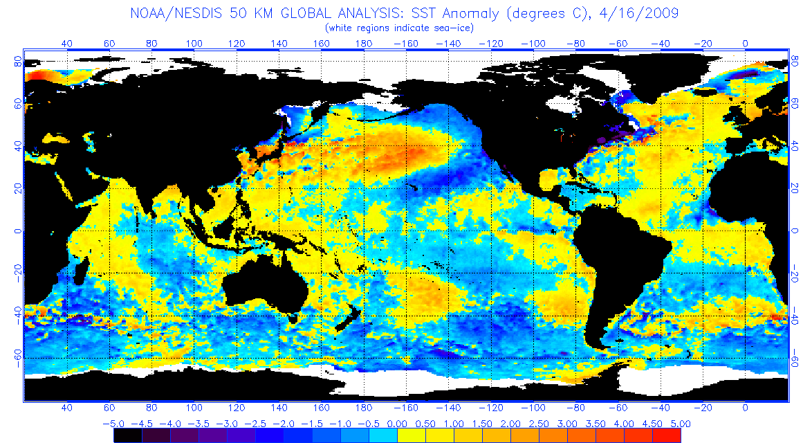
April 2009:
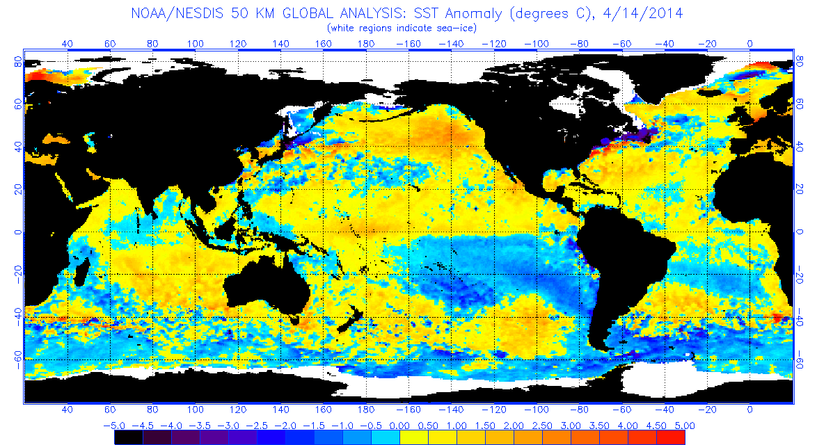
April 2014:
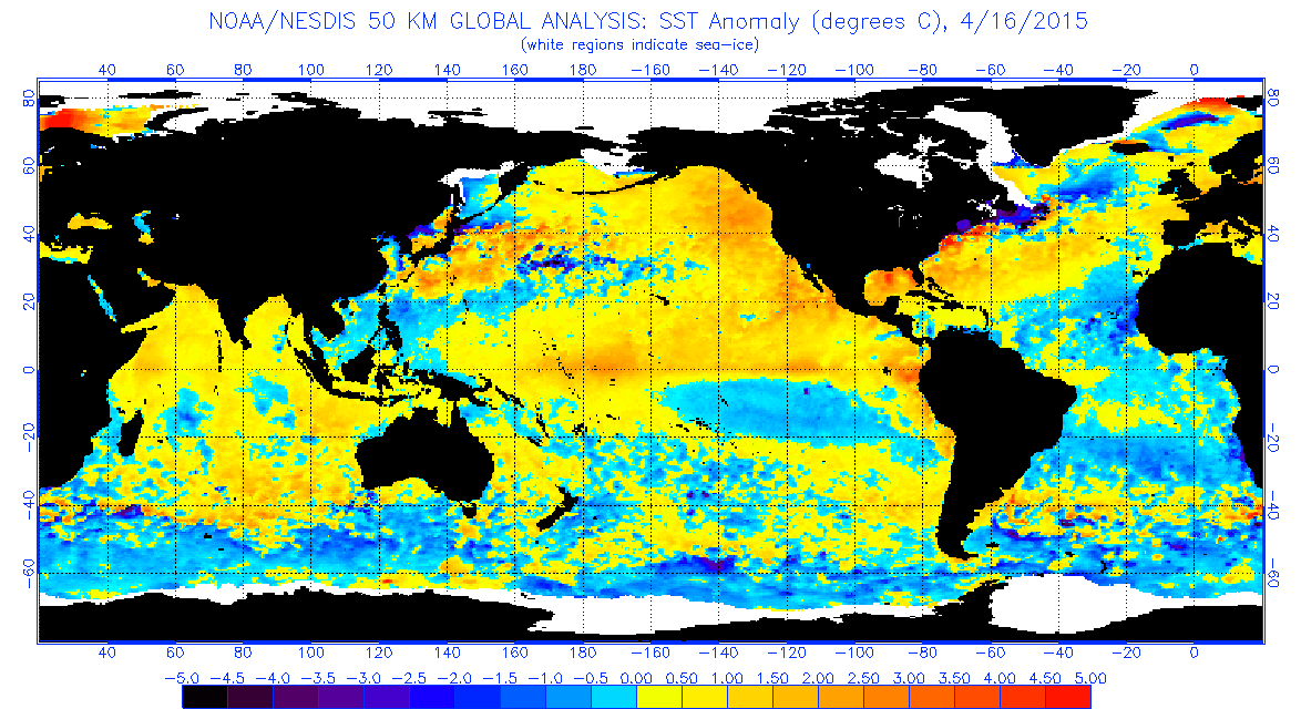
April 2015:
0 likes
RIP Kobe Bryant


Re:
LarryWx wrote:Per this evening's free weekly newsletter, LC still doesn't think we'll have El Niño this summer and even thinks we'll have neutral negative! I don't agree at all as I'm expecting El Nino. However, if he somehow gets this correct, it would be one of the greatest seasonal calls in a number of years:
"Part of the issue here is whether we will have an El Nino that builds through the summer into the fall and winter of 2015. I say no, on the idea that the general mean of forecasts are skewed due to the crazy depiction shown by the PC/CFS outlook (+2.8 deviation at peak). There are a number of outlooks that predict a neutral ENSO anomaly signal. Since the tropics are booming with thunderstorms, and drought appears to be at a minimum in the 'usual suspect' places like Africa, Indonesia, Australia, and South America, the scenario shaping up is to favor a gradual cooling of the equatorial Pacific Ocean to a slightly negative phase this coming summer."
Thanks for sharing, we'll see how he does against the grain. I think he is being a little cautious perhaps spooked by last year? His reasoning has some merit however it's not entirely the picture. There is also heavy rainfall in other parts of North America, South America (where it is usually dry). OLR anomalies clearly indicate rainfall has been favored in the Pacific and dry over the Maritime Continent. Indonesia is experiencing below normal rainfall. Convection in the tropics during max solar insolation of spring in the tropics doesn't mean much come later in the year when ENSO has stronger influences. Look at last year the winds became very unfavorable but yet we still managed a Nino. The winds would need a complete reversal this year to undo the El Nino already in place at the very least we'll keep this Nino going, though I think it will get stronger. I don't see signs of any anomalous strong easterlies to shift us into neutral-Nina territory it's just very difficult to do this late in the game. The warm waters of the Pacific is already deeper east of he dateline than it is west.
Last edited by Ntxw on Sun Apr 19, 2015 8:38 am, edited 3 times in total.
0 likes
The above post and any post by Ntxw is NOT an official forecast and should not be used as such. It is just the opinion of the poster and may or may not be backed by sound meteorological data. It is NOT endorsed by any professional institution including Storm2k. For official information, please refer to NWS products.
Help support Storm2K!
-
xtyphooncyclonex

- Category 5

- Posts: 3891
- Age: 24
- Joined: Sat Dec 08, 2012 9:07 am
- Location: Cebu City
- Contact:
BTW I know this may sound weird but JB is favoring a stronger Niño in the cards this year
0 likes
REMINDER: My opinions that I, or any other NON Pro-Met in this forum, are unofficial. Please do not take my opinions as an official forecast and warning. I am NOT a meteorologist. Following my forecasts blindly may lead to false alarm, danger and risk if official forecasts from agencies are ignored.
-
wxman57

- Moderator-Pro Met

- Posts: 23175
- Age: 68
- Joined: Sat Jun 21, 2003 8:06 pm
- Location: Houston, TX (southwest)
Re: ENSO Updates
I see no signs of the PDO switching to cool or the tropical Pacific cooling. Nothing on which to base a forecast of neutral to La Nina. Everything points to at least a weak to moderate El Nino (perhaps .8C to 1.2C above normal). ECMWF is forecasting even higher pressure and drier air across the tropical Atlantic this summer/fall than last season. Water temperatures from the Caribbean to Africa are a good bit cooler, too.
0 likes
Re: ENSO Updates
cycloneye wrote:Ntxw,I saw on another forum that a big WWB like the one in March is forecast for mid-may. Is that right?
It must be an ECMWF long term forecast? I don't have access to those but there is a WWB coming not as strong as March as mentioned in a previous post. Not sure about May.
0 likes
The above post and any post by Ntxw is NOT an official forecast and should not be used as such. It is just the opinion of the poster and may or may not be backed by sound meteorological data. It is NOT endorsed by any professional institution including Storm2k. For official information, please refer to NWS products.
Help support Storm2K!
Help support Storm2K!
-
xtyphooncyclonex
- Category 5
- Posts: 3891
- Age: 24
- Joined: Sat Dec 08, 2012 9:07 am
- Location: Cebu City
- Contact:
Re: ENSO Updates
wxman57 wrote:I see no signs of the PDO switching to cool or the tropical Pacific cooling. Nothing on which to base a forecast of neutral to La Nina. Everything points to at least a weak to moderate El Nino (perhaps .8C to 1.2C above normal). ECMWF is forecasting even higher pressure and drier air across the tropical Atlantic this summer/fall than last season. Water temperatures from the Caribbean to Africa are a good bit cooler, too.
Yes now it is likely that within the next 3 weeks, we would see a moderate El Niño. I do not know what is LC's basis on his forecast, which is nearly totally and completely impossible.
0 likes
REMINDER: My opinions that I, or any other NON Pro-Met in this forum, are unofficial. Please do not take my opinions as an official forecast and warning. I am NOT a meteorologist. Following my forecasts blindly may lead to false alarm, danger and risk if official forecasts from agencies are ignored.
Looking at buoys (they are warming rapidly as well) along with Satellite I'm thinking 0.9C tomorrow and we get to 1C possibly first update of May.
0 likes
The above post and any post by Ntxw is NOT an official forecast and should not be used as such. It is just the opinion of the poster and may or may not be backed by sound meteorological data. It is NOT endorsed by any professional institution including Storm2k. For official information, please refer to NWS products.
Help support Storm2K!
Help support Storm2K!
-
Yellow Evan

- Professional-Met

- Posts: 16241
- Age: 27
- Joined: Fri Jul 15, 2011 12:48 pm
- Location: Henderson, Nevada/Honolulu, HI
- Contact:
Re: ENSO Updates
Ntxw wrote:cycloneye wrote:Ntxw,I saw on another forum that a big WWB like the one in March is forecast for mid-may. Is that right?
It must be an ECMWF long term forecast? I don't have access to those but there is a WWB coming not as strong as March as mentioned in a previous post. Not sure about May.
I've read on WU it's the CFS.
0 likes
-
Yellow Evan
- Professional-Met
- Posts: 16241
- Age: 27
- Joined: Fri Jul 15, 2011 12:48 pm
- Location: Henderson, Nevada/Honolulu, HI
- Contact:
-
cycloneye
- Admin
- Posts: 149514
- Age: 69
- Joined: Thu Oct 10, 2002 10:54 am
- Location: San Juan, Puerto Rico
Re:
Ntxw wrote:Looking at buoys (they are warming rapidly as well) along with Satellite I'm thinking 0.9C tomorrow and we get to 1C possibly first update of May.
Is at +1.1C as of 18z on April 19 but they will be at +0.9C as they collect the data two days before every weekly Monday update.
0 likes
Visit the Caribbean-Central America Weather Thread where you can find at first post web cams,radars
and observations from Caribbean basin members Click Here
and observations from Caribbean basin members Click Here
-
xtyphooncyclonex
- Category 5
- Posts: 3891
- Age: 24
- Joined: Sat Dec 08, 2012 9:07 am
- Location: Cebu City
- Contact:
Looks like +0.9°C this week

0 likes
REMINDER: My opinions that I, or any other NON Pro-Met in this forum, are unofficial. Please do not take my opinions as an official forecast and warning. I am NOT a meteorologist. Following my forecasts blindly may lead to false alarm, danger and risk if official forecasts from agencies are ignored.
-
xtyphooncyclonex
- Category 5
- Posts: 3891
- Age: 24
- Joined: Sat Dec 08, 2012 9:07 am
- Location: Cebu City
- Contact:
Looks like
Niño 4 = +1.3°C
Niño 3.4 = +0.9°C
Niño 3 = +0.8°C
Niño 1+2 = +1.3°C
Niño 4 = +1.3°C
Niño 3.4 = +0.9°C
Niño 3 = +0.8°C
Niño 1+2 = +1.3°C
0 likes
REMINDER: My opinions that I, or any other NON Pro-Met in this forum, are unofficial. Please do not take my opinions as an official forecast and warning. I am NOT a meteorologist. Following my forecasts blindly may lead to false alarm, danger and risk if official forecasts from agencies are ignored.
-
cycloneye
- Admin
- Posts: 149514
- Age: 69
- Joined: Thu Oct 10, 2002 10:54 am
- Location: San Juan, Puerto Rico
Re:
xtyphooncyclonex wrote:Looks like
Niño 4 = +1.3°C
Niño 3.4 = +0.9°C
Niño 3 = +0.8°C
Niño 1+2 = +1.3°C
Yes,The CPC weekly update text comes later.

0 likes
Visit the Caribbean-Central America Weather Thread where you can find at first post web cams,radars
and observations from Caribbean basin members Click Here
and observations from Caribbean basin members Click Here
-
cycloneye
- Admin
- Posts: 149514
- Age: 69
- Joined: Thu Oct 10, 2002 10:54 am
- Location: San Juan, Puerto Rico
Re: ENSO: CPC weekly update of 4/20/15:El Nino up to +0.9C
Here is the CPC weekly update text with El Nino at +0.9C. The ONI is at +0.5C.
http://www.cpc.noaa.gov/products/analys ... ts-web.pdf
http://www.cpc.noaa.gov/products/analys ... ts-web.pdf
0 likes
Visit the Caribbean-Central America Weather Thread where you can find at first post web cams,radars
and observations from Caribbean basin members Click Here
and observations from Caribbean basin members Click Here
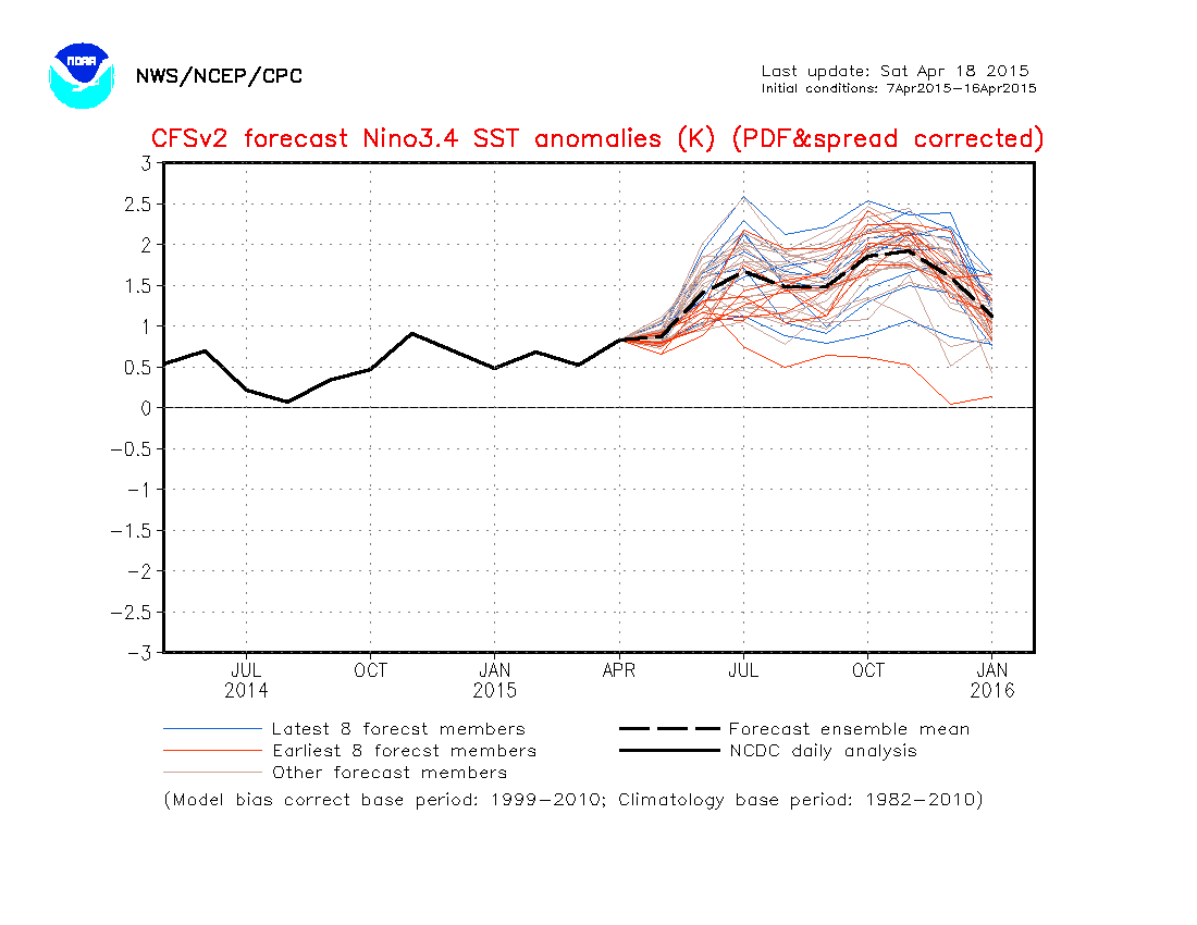
I'm thinking for May's ONI update it's going to rise as compared to fall as in previous. If we get 1C reading by next update (or anytime in May) odds increase significantly we will crawl out of weak Nino and move solidly into moderate Nino, and if the wwb occurs then you can feel more confident of yet a stronger event. In fact to get a May value above 1C is not an easy feat recently only accomplished by 1997 (which by raw numbers we are tracking very close with today's update). If we get a 1C reading next update (still April) that will be even more crazy, but likely happened with stronger double dip Nino's.
As you can see compared just to a few weeks ago a large area of greater than 1.5C is encompassing a swath of Nino 3.4 already. The subsurface shows 2C or greater may be working it's way towards the surface

As you can see compared just to a few weeks ago a large area of greater than 1.5C is encompassing a swath of Nino 3.4 already. The subsurface shows 2C or greater may be working it's way towards the surface
0 likes
The above post and any post by Ntxw is NOT an official forecast and should not be used as such. It is just the opinion of the poster and may or may not be backed by sound meteorological data. It is NOT endorsed by any professional institution including Storm2k. For official information, please refer to NWS products.
Help support Storm2K!
Help support Storm2K!
Re: ENSO: CPC weekly update of 4/20/15:El Nino up to +0.9C
^Consistent with this, the Cowan number as of 6Z today of +1.164 is the warmest I can recall since I started following his graph (last year I think). The chance of the 2nd year Nino ONI (3 month average) peaking only in weak is rapidly dwindling.
0 likes
Personal Forecast Disclaimer:
The posts in this forum are NOT official forecasts and should not be used as such. They are just the opinion of the poster and may or may not be backed by sound meteorological data. They are NOT endorsed by any professional institution or storm2k.org. For official information, please refer to the NHC and NWS products.
The posts in this forum are NOT official forecasts and should not be used as such. They are just the opinion of the poster and may or may not be backed by sound meteorological data. They are NOT endorsed by any professional institution or storm2k.org. For official information, please refer to the NHC and NWS products.
-
cycloneye
- Admin
- Posts: 149514
- Age: 69
- Joined: Thu Oct 10, 2002 10:54 am
- Location: San Juan, Puerto Rico
Re: ENSO: CPC weekly update of 4/20/15:El Nino up to +0.9C
And to reinforce what our friend Larry said about weak ONI dwindling ,this big warm pool means warmup coming in the next few weeks.

0 likes
Visit the Caribbean-Central America Weather Thread where you can find at first post web cams,radars
and observations from Caribbean basin members Click Here
and observations from Caribbean basin members Click Here
-
xtyphooncyclonex
- Category 5
- Posts: 3891
- Age: 24
- Joined: Sat Dec 08, 2012 9:07 am
- Location: Cebu City
- Contact:
Philippine media doing well with this El Niño, as they have been updated with the current situation, effects to economy and to farms. What they need to stop is inisting on the event until 'Hunyo' or June. They seem to be very bearish on the event, which is IMO going to be possibly on par with the 2009-10 event.
Aside from technical ENSO talk, the Philippines is getting a bad dry spell because of the El Niño. Some places have been running out of water, including the Buhisan Dam here in Cebu. High temperatures are recorded throught the country, and dry conditions prevail. Here is an article.
Read more at: http://manilastandardtoday.com/2015/04/ ... es-in-may/
The Philippine Atmospheric Geophysical and Astronomical Services Administration has predicted that the current dry spell could affect even more provinces next month.
“It’s possible that the areas [affected] will increase by May during the peak of summer,” Pagasa weather forecaster Samuel Duran said.
He said that the end of the dry spell currently affecting 30 provinces cannot be predicted yet and will have to undergo further evaluation.
Pagasa has officially declared a dry spell mostly in Mindanao and in some areas in Luzon and the Visayas.
The areas which are experiencing lower than usual rainfall areas are Abra, Benguet, Ifugao, Kalinga, Apayao, Ilocos Norte, Ilocos Sur, La Union, Batanes, Pampanga, Tarlac, Zambales, Palawan, Negros Occidental, Negros Oriental, Bohol, Zamboanga del Norte, Zamboanga del Sur, Zamboanga Sibugay, Camiguin, Lanao del Norte, Misamis Occidental, Misamis Oriental, South Cotabato, Sarangani, Agusan del Norte, Surigao del Norte, Basilan, Lanao del Sur and Sulu.
Meanwhile, Malacanang said that the Department of Agriculture and other government agencies are now focused on helping farmers deal with the El Nino phenomenon.
0 likes
REMINDER: My opinions that I, or any other NON Pro-Met in this forum, are unofficial. Please do not take my opinions as an official forecast and warning. I am NOT a meteorologist. Following my forecasts blindly may lead to false alarm, danger and risk if official forecasts from agencies are ignored.
-
cycloneye
- Admin
- Posts: 149514
- Age: 69
- Joined: Thu Oct 10, 2002 10:54 am
- Location: San Juan, Puerto Rico
Re: ENSO: CPC weekly update of 4/20/15:El Nino up to +0.9C
Eric Blake @EricBlake12 · 2h 2 hours ago
El Niño getting peppy already with Niño 3.4 into the moderate (>1.0) range for a couple of days- impressive for April
El Niño getting peppy already with Niño 3.4 into the moderate (>1.0) range for a couple of days- impressive for April
0 likes
Visit the Caribbean-Central America Weather Thread where you can find at first post web cams,radars
and observations from Caribbean basin members Click Here
and observations from Caribbean basin members Click Here
Who is online
Users browsing this forum: WaveBreaking and 201 guests