Texas Fall-2015

U.S. & Caribbean Weather Discussions and Severe Weather Events

Moderator: S2k Moderators

Forum rules

The posts in this forum are NOT official forecast and should not be used as such. They are just the opinion of the poster and may or may not be backed by sound meteorological data. They are NOT endorsed by any professional institution or STORM2K.

Help Support Storm2K
Message
Author
Brent
S2K Supporter
S2K Supporter
Posts: 38090
Age: 36
Joined: Sun May 16, 2004 10:30 pm
Location: Tulsa Oklahoma
Contact:

Re: Texas Fall-2015

#481 Postby Brent » Sun Sep 27, 2015 3:13 pm

Ptarmigan wrote:
wxman57 wrote:I prefer the 12Z GFS - no cold fronts through Texas until beyond Oct. 10. ;-)

Interesting that the 12Z EC meteogram for DFW on WeatherBell has no cold front through day 10. Lows in the 70s and highs near 90 through 240hrs.


It is Fall. Summer is over. :grrr:


Where has he gotten off too? Cause it doesn't show that now. :lol:
0 likes   
#neversummer

TarrantWx
Category 1
Category 1
Posts: 287
Age: 39
Joined: Thu Jan 30, 2014 10:38 am
Location: Keller, TX

#482 Postby TarrantWx » Sun Sep 27, 2015 3:26 pm

A very interesting read in Larry Cosgrove's WEATHERamerica newsletter yesterday. Some good information about short term weather and what to expect this winter. He's discounting the 82-83 and 97-98 analogs for this winter. He says that SST's are somewhat similar to this time last year and points out that 57-58, 65-66, 72-73 are the best analogs and even throws in 53-54, 77-78, 2009-10, and last winter as useful analogs. I would be happy with most of those analogs I think. Not familiar with 53-54, I'll have to do some digging. Most of all I think the message is that the season is changing for us. I would expect models to have some fits with this for a while until they get all the kinks worked out. Here's a link to the newsletter if you'd like to read all of it: https://groups.google.com/forum/#!forum/weatheramerica
0 likes   

Brent
S2K Supporter
S2K Supporter
Posts: 38090
Age: 36
Joined: Sun May 16, 2004 10:30 pm
Location: Tulsa Oklahoma
Contact:

Re: Texas Fall-2015

#483 Postby Brent » Sun Sep 27, 2015 3:56 pm

FWD's afternoon discussion is encouraging after the next few days which is very likely summer's last gasp

Forecast for next Sunday is much closer to average.

THE LARGE SCALE PATTERN WILL BEGIN TO TRANSITION BY THE END OF THE
WEEK WITH A LOW PRESSURE SYSTEM DEVELOPING OVER THE PACIFIC
NORTHWEST AND ANOTHER STRONGER LOW PRESSURE SYSTEM DEEPENING NEAR
THE GREAT LAKES REGION. THIS PATTERN WILL INITIALLY RESULT IN SOME
COOLER AIR REACHING NORTH TEXAS SATURDAY THROUGH THE FIRST PART OF
NEXT. THE EXTENDED MODELS STILL DIFFER ON THE FATE OF THE PACIFIC
NORTHWEST SYSTEM SO DO NOT HAVE HIGH CONFIDENCE IN PRECIPITATION
CHANCES. HOWEVER...WITH NORTHWEST FLOW ALOFT AND A COLD FRONT
EXPECTED...WILL ADD SOME SLIGHT CHANCES POPS MAINLY NORTH OF
INTERSTATE 20 FRIDAY NIGHT AND SATURDAY.

IF THE UPPER PATTERN REMAINS PROGRESSIVE INTO THE FIRST FULL WEEK
OF OCTOBER...AS THE MODELS SUGGEST...PRECIPITATION CHANCES SHOULD
INCREASE ACROSS NORTH TEXAS.
0 likes   
#neversummer

User avatar
Ntxw
Storm2k Moderator
Storm2k Moderator
Posts: 22785
Joined: Wed Oct 21, 2009 6:34 pm
Location: DFW, Texas

Re: Texas Fall-2015

#484 Postby Ntxw » Sun Sep 27, 2015 4:42 pm

One thing for sure, we may not see or feel it outside...but 500mb weakness has been sitting over our region this weekend and will quickly be reimbursed. Higher heights over the top, that's the pattern many forecasters are expecting. Big storm crashing into northern California next week. I would not be too worried or caught up with surface depictions from model runs beyond 5 days...the EPO is going down finally.

Daily EPO index

Code: Select all

2015 09 01   64.26
2015 09 02  -11.53
2015 09 03  -46.78
2015 09 04  -50.99
2015 09 05  -35.75
2015 09 06  -17.61
2015 09 07    9.39
2015 09 08   42.20
2015 09 09   44.92
2015 09 10   33.85
2015 09 11   14.78
2015 09 12   23.89
2015 09 13   21.59
2015 09 14   62.41
2015 09 15   89.67
2015 09 16  107.10
2015 09 17  150.57
2015 09 18  143.19
2015 09 19  137.79
2015 09 20  134.46
2015 09 21  126.20
2015 09 22  104.90
2015 09 23   35.76
2015 09 24    9.26
2015 09 25    1.28
0 likes   
The above post and any post by Ntxw is NOT an official forecast and should not be used as such. It is just the opinion of the poster and may or may not be backed by sound meteorological data. It is NOT endorsed by any professional institution including Storm2k. For official information, please refer to NWS products.

  Help support Storm2K!
Help Support Storm2K

User avatar
Ntxw
Storm2k Moderator
Storm2k Moderator
Posts: 22785
Joined: Wed Oct 21, 2009 6:34 pm
Location: DFW, Texas

#485 Postby Ntxw » Sun Sep 27, 2015 5:32 pm

Houston has only had a high temp of 78 today just sayin with a slight north wind. That ULL has kept it damp and coolish down in wxman57 HQ. I bet those meteograms didn't prepare him for such arctic chill :cheesy:
0 likes   
The above post and any post by Ntxw is NOT an official forecast and should not be used as such. It is just the opinion of the poster and may or may not be backed by sound meteorological data. It is NOT endorsed by any professional institution including Storm2k. For official information, please refer to NWS products.


  Help support Storm2K!

Help Support Storm2K


Brent
S2K Supporter
S2K Supporter
Posts: 38090
Age: 36
Joined: Sun May 16, 2004 10:30 pm
Location: Tulsa Oklahoma
Contact:

Re:

#486 Postby Brent » Sun Sep 27, 2015 5:45 pm

Ntxw wrote:Houston has only had a high temp of 78 today just sayin with a slight north wind. That ULL has kept it damp and coolish down in wxman57 HQ. I bet those meteograms didn't prepare him for such arctic chill :cheesy:


:lol:

The GFS last several runs has gone even lower on temps for next weekend in DFW... may not even hit 70 Saturday, Sunday, or Monday. Has the front crashing through early on Friday with temps plunging in the afternoon. Actually has 50s during the day on Saturday with some light rain around. :double: At the same time there appears to be a snowstorm in the Rockies west of Denver. "Warms up" to the upper 60s on Sunday/Monday. I find it a little hard to believe it'd be that cool but it's going to be interesting.

Edit: Meteogram has 50s for DFW on Saturday all day with about an inch of rain LOL

Sunday... highs in the lower 60s

Monday... highs in the upper 60s
Last edited by Brent on Sun Sep 27, 2015 7:11 pm, edited 2 times in total.
0 likes   
#neversummer

User avatar
Tireman4
S2K Supporter
S2K Supporter
Posts: 5853
Age: 59
Joined: Fri Jun 30, 2006 1:08 pm
Location: Humble, Texas
Contact:

Re:

#487 Postby Tireman4 » Sun Sep 27, 2015 6:15 pm

Ntxw wrote:Houston has only had a high temp of 78 today just sayin with a slight north wind. That ULL has kept it damp and coolish down in wxman57 HQ. I bet those meteograms didn't prepare him for such arctic chill :cheesy:


Yes sir and my run felt it. Thank you Mother Nature...
0 likes   

aggiecutter
Category 5
Category 5
Posts: 1753
Joined: Thu Oct 14, 2004 9:22 pm
Location: Texarkana

Re: Texas Fall-2015

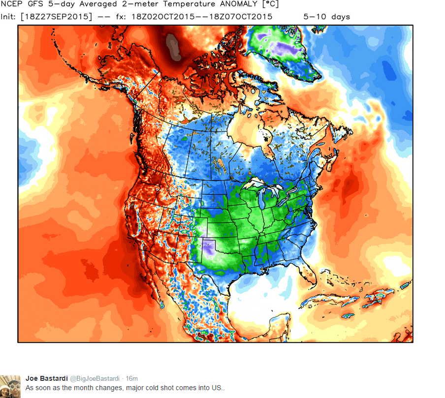
#488 Postby aggiecutter » Sun Sep 27, 2015 7:09 pm

Image
0 likes   

User avatar
Ntxw
Storm2k Moderator
Storm2k Moderator
Posts: 22785
Joined: Wed Oct 21, 2009 6:34 pm
Location: DFW, Texas

Re: Re:

#489 Postby Ntxw » Sun Sep 27, 2015 7:12 pm

Brent wrote:The GFS last several runs has gone even lower on temps for next weekend in DFW... may not even hit 70 Saturday, Sunday, or Monday. Has the front crashing through early on Friday with temps plunging in the afternoon. Actually has 50s during the day on Saturday with some light rain around. :double: At the same time there appears to be a snowstorm in the Rockies west of Denver. "Warms up" to the upper 60s on Sunday/Monday. I find it a little hard to believe it'd be that cool but it's going to be interesting.

Edit: Meteogram has 50s for DFW on Saturday all day with about an inch of rain LOL

Sunday... highs in the lower 60s

Monday... highs in the upper 60s


Sure does 50s during the day sounds nice. A few years ago (2012?) had a similar cold snap early in the month (OCT). Before that it was 2009.
0 likes   
The above post and any post by Ntxw is NOT an official forecast and should not be used as such. It is just the opinion of the poster and may or may not be backed by sound meteorological data. It is NOT endorsed by any professional institution including Storm2k. For official information, please refer to NWS products.


  Help support Storm2K!

Help Support Storm2K


TarrantWx
Category 1
Category 1
Posts: 287
Age: 39
Joined: Thu Jan 30, 2014 10:38 am
Location: Keller, TX

Re: Texas Fall-2015

#490 Postby TarrantWx » Sun Sep 27, 2015 9:56 pm

aggiecutter wrote:Image


12z GFS has a 1045mb high dropping out of Western Canada next Saturday! :D :cold:

And then the pattern reloads at the end of the GFS run.
0 likes   

Brent
S2K Supporter
S2K Supporter
Posts: 38090
Age: 36
Joined: Sun May 16, 2004 10:30 pm
Location: Tulsa Oklahoma
Contact:

Re: Texas Fall-2015

#491 Postby Brent » Mon Sep 28, 2015 1:12 am

0z GFS for DFW

Friday: Mid 70s
Saturday: Upper 70s
Sunday: Low 60s with some rain
Monday: Around 70

:D
0 likes   
#neversummer

User avatar
dhweather
S2K Supporter
S2K Supporter
Posts: 6199
Joined: Sat Aug 14, 2004 9:29 pm
Location: Heath, TX
Contact:

Re: Texas Fall-2015

#492 Postby dhweather » Mon Sep 28, 2015 12:06 pm

12Z GFS rolling in

Image

Image


Sadly, the chances for rain appear to be extremely low for Heath. 10 day total precip:

Image
0 likes   
The above post and any post by dhweather is NOT an official forecast and should not be used as such. It is just the opinion of the poster and may or may not be backed by sound meteorological data. It is NOT endorsed by any professional institution including storm2k.org. For official information, please refer to NWS products.

TarrantWx
Category 1
Category 1
Posts: 287
Age: 39
Joined: Thu Jan 30, 2014 10:38 am
Location: Keller, TX

#493 Postby TarrantWx » Mon Sep 28, 2015 1:02 pm

12z GFS sticking to its guns about bringing a strong cold front through on Friday, and then some rain on Sunday. I'll be interested to see what the Euro says. There should be some interesting AFD's out of the NWS offices this afternoon. They're going to have to start changing their tune about this weekend pretty soon if this trend continues. We're less than 5 days out now until the cold front moves through. 86 on Saturday in DFW will not verify given these model runs. One interesting thing to note though is that the cold front seems to backdoor in from the NE. DFW and Houston see the impacts first before Austin and SA.
0 likes   

Brent
S2K Supporter
S2K Supporter
Posts: 38090
Age: 36
Joined: Sun May 16, 2004 10:30 pm
Location: Tulsa Oklahoma
Contact:

Re:

#494 Postby Brent » Mon Sep 28, 2015 1:06 pm

TarrantWx wrote:12z GFS sticking to its guns about bringing a strong cold front through on Friday, and then some rain on Sunday. I'll be interested to see what the Euro says. There should be some interesting AFD's out of the NWS offices this afternoon. They're going to have to start changing their tune about this weekend pretty soon if this trend continues. We're less than 5 days out now until the cold front moves through. 86 on Saturday in DFW will not verify given these model runs. One interesting thing to note though is that the cold front seems to backdoor in from the NE. DFW and Houston see the impacts first before Austin and SA.


Indeed. The GFS has not backed off this solution which is making it more believable.

DFW

81 on Friday
75 on Saturday
59 on Sunday
72 on Monday

:double:
0 likes   
#neversummer

User avatar
Tireman4
S2K Supporter
S2K Supporter
Posts: 5853
Age: 59
Joined: Fri Jun 30, 2006 1:08 pm
Location: Humble, Texas
Contact:

#495 Postby Tireman4 » Mon Sep 28, 2015 1:23 pm

HGX is not discussing it...


PREV DISCUSSION... /ISSUED /

AVIATION...
LOW OFF THE COAST AIDING THE GENERATION OF INLAND RAIN ROTATING
IN FROM EASTERN TEXAS THIS MORNING. -RA WITH VCSH/VFR TO TEMPO
MVFR WITHIN RAIN/LIGHT NORTH BREEZE THE THEME THE FIRST 6 HOURS OF
THIS PACKAGE. PRECIPITATION ACTIVITY WILL WANE THROUGH THE
DAY...BECOMING MORE WIDESPREAD AND SHOWERY IN NATURE. PRIMARILY
VFR DECKS WILL SCATTER OUT THIS EVENING. THERE IS A HEIGHTENED
PROBABILITY OF EARLY TUESDAY SHALLOW GROUND FOG DUE TO WEAKENING
WINDS AND CLEARING SKIES. IF N-NE BREEZES STAY UP THEN A NEAR
SUNRISE STRATUS DECK ISN`T OUT OF THE QUESTION. 31

PREV DISCUSSION... /ISSUED /

DISCUSSION...
THE NEARLY STATIONARY MID/UPPER LEVEL LOW ALONG THE TEXAS
COAST AND A WEAK SURFACE LOW OFFSHORE WILL CONTINUE TO PRODUCE
PERIODS OF RAIN WITH EMBEDDED SHOWERS AND THUNDERSTORMS ACROSS
PARTS OF SOUTHEAST TEXAS TODAY. LOCALLY HEAVY RAINFALL (A QUICK
1 TO 2 INCHES) WILL CONTINUE TO BE A POSSIBILITY...ESPECIALLY
AROUND THE GALVESTON BAY AREA. MODELS OPEN UP THE LOW AND BEGIN
TO SLOWLY LIFT IT OFF TO THE NORTHEAST AND EAST TONIGHT AND ON
TUESDAY RESULTING IN GRADUALLY DECREASING RAIN COVERAGE ACROSS
OUR AREA. A DRIER AIRMASS BEGINS WORKING ITS WAY INTO SOUTHEAST
TEXAS FROM THE WEST ON WEDNESDAY...AND THE REST OF THE WEEK LOOKS
TO BE DRY AS THE AREA RESIDES SOMEWHERE BETWEEN UPPER RIDGING TO
THE WEST AND A DEEPENING TROF TO THE EAST. 42

MARINE...
LOW PRESSURE CENTERED OVER OUR FAR OFFSHORE WATERS IS FORECAST TO
WOBBLE ABOUT THE NORTHWESTERN GULF THROUGH TOMORROW. DURING THIS
TIME...PERIODIC RAIN WITH THUNDERSTORMS WILL IMPACT THE LOCAL
WATERS. WINDS WILL QUICKLY STRENGTHEN TO ADVISORY LEVELS...WITH
AGITATED SEAS...IN OR AROUND THUNDERSTORMS. TODAY`S GENERAL TREND
WILL BE FOR WEAKENING EASTERLIES TURNING MORE NORTHERLY THROUGH THE
EVENING HOURS...SEA HEIGHTS SUBSIDING TO AN AVERAGE 2 TO 3 FEET.
WESTERN U.S. UPPER RIDGING WILL NUDGE FURTHER EAST AND AID IN
DISPLACING UPPER TROUGHING EAST...LESSENING MID TO LATE WEEK
PRECIPITATION CHANCES. HIGHER PRESSURES OVER THE PLAINS
STATES...WITH LOWER SOUTHEASTERN U.S. PRESSURE...WILL MAINTAIN A
LIGHT TO MODERATE NORTHEAST FLOW PATTERN THAT MAY REACH CAUTION
LEVELS AGAIN THURSDAY AND/OR FRIDAY. THIS PERSISTENT NE FETCH WILL
PUSH LATE WEEK AVERAGE WAVE HEIGHTS BACK UP INTO THE 3 TO 4 FOOT
RANGE. 31

&&

But...the long range....

This Afternoon A 50 percent chance of showers and thunderstorms. Cloudy, with a high near 79. Northeast wind around 10 mph.
TonightA 30 percent chance of showers and thunderstorms, mainly before 1am. Mostly cloudy, with a low around 70. North wind around 5 mph.
TuesdayA 30 percent chance of showers and thunderstorms, mainly after 1pm. Mostly cloudy, with a high near 86. North wind 5 to 10 mph.
Tuesday NightA 20 percent chance of showers and thunderstorms. Mostly cloudy, with a low around 69. North wind around 5 mph.
WednesdayA 20 percent chance of showers and thunderstorms. Mostly sunny, with a high near 88. North wind 5 to 10 mph.
Wednesday NightPartly cloudy, with a low around 70.
ThursdayMostly sunny, with a high near 88.
Thursday NightMostly clear, with a low around 65.
FridaySunny, with a high near 87.
Friday NightMostly clear, with a low around 63.
SaturdayMostly sunny, with a high near 86.
Saturday NightPartly cloudy, with a low around 64.
SundayA 20 percent chance of showers and thunderstorms. Mostly sunny, with a high near 84.
0 likes   

User avatar
gboudx
S2K Supporter
S2K Supporter
Posts: 4080
Joined: Thu Sep 04, 2003 1:39 pm
Location: Rockwall, Tx but from Harvey, La

Re: Re:

#496 Postby gboudx » Mon Sep 28, 2015 1:31 pm

Brent wrote:
Indeed. The GFS has not backed off this solution which is making it more believable.

DFW

81 on Friday
75 on Saturday
59 on Sunday
72 on Monday

:double:


What's the low on Saturday morning that it's forecasting? I'm running in a 5k that morning and will be ecstatic with temps in the 60's.

Oh, and cue wxman57 to squash this in 5.....4....3...... ;)
0 likes   

User avatar
Tireman4
S2K Supporter
S2K Supporter
Posts: 5853
Age: 59
Joined: Fri Jun 30, 2006 1:08 pm
Location: Humble, Texas
Contact:

Re: Re:

#497 Postby Tireman4 » Mon Sep 28, 2015 1:53 pm

gboudx wrote:
Brent wrote:
Indeed. The GFS has not backed off this solution which is making it more believable.

DFW

81 on Friday
75 on Saturday
59 on Sunday
72 on Monday

:double:


What's the low on Saturday morning that it's forecasting? I'm running in a 5k that morning and will be ecstatic with temps in the 60's.

Oh, and cue wxman57 to squash this in 5.....4....3...... ;)


Do not worry. He is hanging around. LOL
0 likes   

TarrantWx
Category 1
Category 1
Posts: 287
Age: 39
Joined: Thu Jan 30, 2014 10:38 am
Location: Keller, TX

Re: Re:

#498 Postby TarrantWx » Mon Sep 28, 2015 2:13 pm

gboudx wrote:
Brent wrote:
Indeed. The GFS has not backed off this solution which is making it more believable.

DFW

81 on Friday
75 on Saturday
59 on Sunday
72 on Monday

:double:


What's the low on Saturday morning that it's forecasting? I'm running in a 5k that morning and will be ecstatic with temps in the 60's.

Oh, and cue wxman57 to squash this in 5.....4....3...... ;)


As of right now the 12z GFS is forecasting a low of 60 in the DFW area Saturday morning warming up to 75 early afternoon
0 likes   

User avatar
JDawg512
Category 5
Category 5
Posts: 1076
Age: 45
Joined: Mon Aug 26, 2013 8:56 pm
Location: Austin
Contact:

Re: Texas Fall-2015

#499 Postby JDawg512 » Mon Sep 28, 2015 2:39 pm

Patiently waiting for EWX's afternoon update. I'm not expecting too much given their frequent lackluster discussions but they did mention the possibility of a front with their overnight update so we shall see.
0 likes   
Resident Rain Miser

I am a weather hobbyist living 3.5 miles south of Downtown Austin and in no way or fashion should anything I say concerning forecasts be taken seriously. Please check your local NWS for accurate weather forecasting and conditions.

Brent
S2K Supporter
S2K Supporter
Posts: 38090
Age: 36
Joined: Sun May 16, 2004 10:30 pm
Location: Tulsa Oklahoma
Contact:

Re: Texas Fall-2015

#500 Postby Brent » Mon Sep 28, 2015 2:57 pm

The Weather Channel has 74 for a high Sunday here on their app...

disclaimer: It is the weather channel
0 likes   
#neversummer


Return to “USA & Caribbean Weather”

Who is online

Users browsing this forum: No registered users and 12 guests