ATL: COLIN - Post-Tropical - Discussion
Moderator: S2k Moderators
-
SouthDadeFish

- Professional-Met

- Posts: 2835
- Joined: Thu Sep 23, 2010 2:54 pm
- Location: Miami, FL
- Contact:
Re: ATL: THREE - Tropical Depression - Discussion
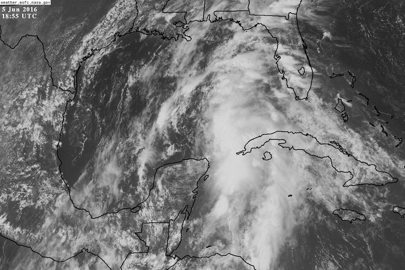
Low-level clouds are beginning to thicken to the west of the mid-level swirl. The stage is being set for another convective burst in that region over the next 6-12 hours. I'm guessing with the new convective burst, we will probably see the consolidation of a surface circulation.
0 likes

Re: ATL: THREE - Tropical Depression - Discussion
First bands have arrived here in hernando county north of tampa with gusty winds and thunder.
0 likes
Robbielyn McCrary
I know just about enough to sound like I know what I'm talking about sometimes. But for your safety please follow the nhc for truly professional forecasting.
I know just about enough to sound like I know what I'm talking about sometimes. But for your safety please follow the nhc for truly professional forecasting.
-
CrazyC83
- Professional-Met
- Posts: 34315
- Joined: Tue Mar 07, 2006 11:57 pm
- Location: Deep South, for the first time!
Re: ATL: THREE - Recon
000
URNT15 KNHC 051903
AF307 0103A CYCLONE HDOB 22 20160605
185400 2331N 08830W 9667 00356 //// +235 //// 051015 015 013 000 01
185430 2332N 08831W 9662 00360 //// +236 //// 052015 015 013 000 01
185500 2332N 08833W 9671 00355 //// +235 //// 060015 015 012 000 05
185530 2334N 08833W 9662 00361 0066 +238 +231 059013 015 /// /// 03
185600 2334N 08832W 9664 00359 0066 +236 +230 058012 013 014 000 05
185630 2334N 08830W 9666 00356 0066 +235 +231 059012 012 013 000 01
185700 2334N 08828W 9664 00358 0066 +235 +229 054012 012 014 000 01
185730 2335N 08827W 9664 00358 0066 +240 +219 057011 012 012 000 00
185800 2335N 08825W 9664 00358 0065 +239 +221 059010 011 012 000 00
185830 2335N 08824W 9664 00356 0064 +239 +227 062010 011 011 000 00
185900 2335N 08822W 9664 00356 0064 +236 +227 058010 010 011 000 00
185930 2335N 08820W 9664 00355 0064 +235 +231 056010 011 011 000 01
190000 2335N 08819W 9663 00356 0063 +237 +228 049011 011 012 000 00
190030 2335N 08817W 9664 00355 0063 +235 +229 050008 010 013 000 00
190100 2336N 08816W 9664 00356 0064 +235 +225 059008 009 013 000 00
190130 2336N 08814W 9664 00358 0065 +237 +226 075007 008 012 000 00
190200 2336N 08812W 9664 00356 0065 +235 +228 093006 007 011 000 00
190230 2336N 08811W 9664 00359 0066 +237 +225 096006 006 010 000 00
190300 2336N 08809W 9667 00356 0067 +235 +228 112007 008 010 000 00
190330 2336N 08807W 9662 00361 0067 +234 +231 117007 008 010 000 00
$$
;
0 likes
-
cycloneye

- Admin

- Posts: 149418
- Age: 69
- Joined: Thu Oct 10, 2002 10:54 am
- Location: San Juan, Puerto Rico
Re: ATL: THREE - Recon

0 likes
Visit the Caribbean-Central America Weather Thread where you can find at first post web cams,radars
and observations from Caribbean basin members Click Here
and observations from Caribbean basin members Click Here

Re: ATL: THREE - Tropical Depression - Discussion
Is starting to get that look, but the shear will keep it from organizing that fast before landfall tomorrow night.
0 likes
-
jlauderdal
- S2K Supporter

- Posts: 7240
- Joined: Wed May 19, 2004 5:46 am
- Location: NE Fort Lauderdale
- Contact:
Re: ATL: THREE - Tropical Depression - Discussion
just had a waterspout off south beach in miami
0257 PM WATER SPOUT 1 S SOUTH BEACH 25.78N 80.13W
06/05/2016 MIAMI-DADE FL FIRE DEPT/RESCUE
MIAMI BEACH OCEAN RESCUE CALLED TO REPORT A WATERSPOUT
OFFSHORE MIAMI BEACH AT 257PM
0257 PM WATER SPOUT 1 S SOUTH BEACH 25.78N 80.13W
06/05/2016 MIAMI-DADE FL FIRE DEPT/RESCUE
MIAMI BEACH OCEAN RESCUE CALLED TO REPORT A WATERSPOUT
OFFSHORE MIAMI BEACH AT 257PM
0 likes
-
CrazyC83
- Professional-Met
- Posts: 34315
- Joined: Tue Mar 07, 2006 11:57 pm
- Location: Deep South, for the first time!
Re: ATL: THREE - Tropical Depression - Discussion
From about 16Z but just received. TS force winds east of the Yucatan. Does not show the newly formed center though.

Last edited by CrazyC83 on Sun Jun 05, 2016 2:13 pm, edited 1 time in total.
0 likes
Re: ATL: THREE - Tropical Depression - Discussion
SouthDadeFish wrote:Low-level clouds are beginning to thicken to the west of the mid-level swirl. The stage is being set for another convective burst in that region over the next 6-12 hours. I'm guessing with the new convective burst, we will probably see the consolidation of a surface circulation.
I agree, as if the MLC is starting to take over the whole system.
0 likes
-
CrazyC83
- Professional-Met
- Posts: 34315
- Joined: Tue Mar 07, 2006 11:57 pm
- Location: Deep South, for the first time!
Re: ATL: THREE - Recon
000
URNT15 KNHC 051913
AF307 0103A CYCLONE HDOB 23 20160605
190400 2337N 08806W 9667 00358 0067 +237 +228 111009 009 009 000 00
190430 2337N 08804W 9663 00360 0067 +236 +228 115008 009 010 000 00
190500 2337N 08802W 9663 00360 0067 +233 +229 112008 009 009 000 01
190530 2337N 08801W 9663 00360 0067 +233 +229 112007 008 008 000 01
190600 2337N 08759W 9665 00358 0067 +238 +223 116008 008 010 000 00
190630 2337N 08758W 9663 00360 0067 +240 +225 117009 010 008 000 00
190700 2338N 08756W 9663 00360 0067 +239 +229 117009 009 009 000 00
190730 2338N 08754W 9664 00359 0067 +238 +230 121010 011 009 000 00
190800 2338N 08753W 9663 00360 0067 +235 +232 114010 010 009 000 00
190830 2338N 08751W 9664 00358 0067 +234 +232 111010 010 009 000 01
190900 2338N 08750W 9664 00359 0067 +235 +232 110010 010 010 002 00
190930 2338N 08748W 9664 00359 0067 +235 +233 109009 010 008 000 01
191000 2338N 08746W 9663 00359 //// +234 //// 108007 008 007 000 01
191030 2339N 08745W 9664 00359 0068 +235 +232 106007 008 008 000 05
191100 2339N 08743W 9663 00360 0067 +235 +233 105008 008 007 000 01
191130 2339N 08741W 9664 00359 0067 +235 +233 100008 008 007 000 01
191200 2339N 08740W 9666 00358 0067 +235 +233 101008 008 007 000 00
191230 2339N 08738W 9664 00360 0068 +236 +233 101007 008 009 002 01
191300 2339N 08737W 9663 00360 0068 +236 +233 107006 007 009 002 00
191330 2340N 08735W 9664 00359 //// +235 //// 100006 007 006 001 05
$$
;
0 likes
-
cycloneye
- Admin
- Posts: 149418
- Age: 69
- Joined: Thu Oct 10, 2002 10:54 am
- Location: San Juan, Puerto Rico
Re: ATL: THREE - Recon

0 likes
Visit the Caribbean-Central America Weather Thread where you can find at first post web cams,radars
and observations from Caribbean basin members Click Here
and observations from Caribbean basin members Click Here
-
gatorcane

- S2K Supporter
- Posts: 23708
- Age: 48
- Joined: Sun Mar 13, 2005 3:54 pm
- Location: Boca Raton, FL
Re: ATL: THREE - Tropical Depression - Discussion
click link and speed up. The spin NE of Yucatan is quite distinct.
http://rammb.cira.colostate.edu/ramsdis ... display=12
Perhaps this MLC will consolidate with the LLC further NW
http://rammb.cira.colostate.edu/ramsdis ... display=12
Perhaps this MLC will consolidate with the LLC further NW
0 likes
-
northjaxpro

- S2K Supporter
- Posts: 8900
- Joined: Mon Sep 27, 2010 11:21 am
- Location: Jacksonville, FL
Re: ATL: THREE - Tropical Depression - Discussion
jlauderdal wrote:just had a waterspout off south beach in miami
0257 PM WATER SPOUT 1 S SOUTH BEACH 25.78N 80.13W
06/05/2016 MIAMI-DADE FL FIRE DEPT/RESCUE
MIAMI BEACH OCEAN RESCUE CALLED TO REPORT A WATERSPOUT
OFFSHORE MIAMI BEACH AT 257PM
This is the first of what I think will be numerous reports of this nature the next 36-48 hours. Set-up is really decent for tornadoes across the peninsula, especially late tomorrow into tomorrow night.
Last edited by northjaxpro on Sun Jun 05, 2016 2:22 pm, edited 1 time in total.
0 likes
NEVER, EVER SAY NEVER in the tropics and weather in general, and most importantly, with life itself!!
________________________________________________________________________________________
Fay 2008 Beryl 2012 Debby 2012 Colin 2016 Hermine 2016 Julia 2016 Matthew 2016 Irma 2017 Dorian 2019
________________________________________________________________________________________
Fay 2008 Beryl 2012 Debby 2012 Colin 2016 Hermine 2016 Julia 2016 Matthew 2016 Irma 2017 Dorian 2019
Re: ATL: THREE - Tropical Depression - Discussion
Would it be upgraded based on that data or does,it need to be verified by recon?
0 likes
-
Evil Jeremy

- S2K Supporter
- Posts: 5463
- Age: 32
- Joined: Mon Apr 10, 2006 2:10 pm
- Location: Los Angeles, CA
Re: ATL: THREE - Tropical Depression - Discussion
Looks to me like recon is on it's way to the NE feature.
0 likes
Frances 04 / Jeanne 04 / Katrina 05 / Wilma 05 / Fay 08 / Debby 12 / Andrea 13 / Colin 16 / Hermine 16 / Matthew 16 / Irma 17

Re: ATL: THREE - Tropical Depression - Discussion
Just my opinion here.......... and Politics and local deteriorating weather conditions aside, I just don't agree with the upgraded classification to T.D. 3 - at least not yet.
When looking at present co-location of convection and banding features, I just don't believe that this system has displayed quite enough organization over enough hours to quite meet that designation. Though the system definately appears to becoming slowly more organized and model support suggests some further development, the upgrade seems a bit quick compared to the inconsistancy of much slower upgrades to a number of past year tropical system upgrades. Realizing that this system is in the Southern Gulf and the need for coastal surge and flooding conditions I understand a need for people to take notice, but not at the expense of unneccessary center relocations caused by a tropical system that might yet to fully get its act together. Overall, me thinks there's a better chance that some circulation might be trying to form close to 22.0 and 86.5 (which others have plainly noted and commented thus far as well). I'm guessing that it might well reflect down to at least 850mb level and perhaps getting closer to the surface with time. I see this as equally or more likely point to become the dominant center, rather than NHC's thinking that greater consolidation will eventually occur around and over the present official center of T.D. 3. Naturally, this feature could just as well spin out and be pulled northward into the broader low level center point of the depression too.
When looking at present co-location of convection and banding features, I just don't believe that this system has displayed quite enough organization over enough hours to quite meet that designation. Though the system definately appears to becoming slowly more organized and model support suggests some further development, the upgrade seems a bit quick compared to the inconsistancy of much slower upgrades to a number of past year tropical system upgrades. Realizing that this system is in the Southern Gulf and the need for coastal surge and flooding conditions I understand a need for people to take notice, but not at the expense of unneccessary center relocations caused by a tropical system that might yet to fully get its act together. Overall, me thinks there's a better chance that some circulation might be trying to form close to 22.0 and 86.5 (which others have plainly noted and commented thus far as well). I'm guessing that it might well reflect down to at least 850mb level and perhaps getting closer to the surface with time. I see this as equally or more likely point to become the dominant center, rather than NHC's thinking that greater consolidation will eventually occur around and over the present official center of T.D. 3. Naturally, this feature could just as well spin out and be pulled northward into the broader low level center point of the depression too.
0 likes
Andy D
(For official information, please refer to the NHC and NWS products.)
(For official information, please refer to the NHC and NWS products.)
Re: ATL: THREE - Tropical Depression - Discussion
Recon will probably find TS force winds in those thunderstorms. I'd be kinda surprised if they didn't.
0 likes
-
wxman57

- Moderator-Pro Met

- Posts: 23174
- Age: 68
- Joined: Sat Jun 21, 2003 8:06 pm
- Location: Houston, TX (southwest)
Re: ATL: THREE - Tropical Depression - Discussion
Squalls are elongating northward rather than wrapping around any center. It may have a hard time developing a well-defined LLC up until landfall.
0 likes
-
tropicwatch

- Category 5

- Posts: 3426
- Age: 62
- Joined: Sat Jun 02, 2007 10:01 am
- Location: The Villages, Florida
- Contact:
Re: ATL: THREE - Tropical Depression - Discussion
Looks like convection bending around the east side of the area ne of Yucatan.
http://www.ssd.noaa.gov/PS/TROP/floaters/03L/imagery/avn-animated.gif
http://www.ssd.noaa.gov/PS/TROP/floaters/03L/imagery/avn-animated.gif
0 likes
Tropicwatch
Agnes 72', Eloise 75, Elena 85', Kate 85', Charley 86', Florence 88', Beryl 94', Dean 95', Erin 95', Opal 95', Earl 98', Georges 98', Ivan 2004', Arlene 2005', Dennis 2005', Ida 2009' Debby 2012' Irma 2017' Michael 2018'
Agnes 72', Eloise 75, Elena 85', Kate 85', Charley 86', Florence 88', Beryl 94', Dean 95', Erin 95', Opal 95', Earl 98', Georges 98', Ivan 2004', Arlene 2005', Dennis 2005', Ida 2009' Debby 2012' Irma 2017' Michael 2018'
-
Yellow Evan

- Professional-Met
- Posts: 16236
- Age: 27
- Joined: Fri Jul 15, 2011 12:48 pm
- Location: Henderson, Nevada/Honolulu, HI
- Contact:
Re: ATL: THREE - Tropical Depression - Discussion
Honestly not seeing a center relocation near the MLC quite yet. Still think the LLC is far removed from the center, and this is what recon is reporting.
0 likes
Re: ATL: THREE - Tropical Depression - Discussion
wxman57 wrote:Squalls are elongating northward rather than wrapping around any center. It may have a hard time developing a well-defined LLC up until landfall.
Not surprising with all that shear.
0 likes
Robbielyn McCrary
I know just about enough to sound like I know what I'm talking about sometimes. But for your safety please follow the nhc for truly professional forecasting.
I know just about enough to sound like I know what I'm talking about sometimes. But for your safety please follow the nhc for truly professional forecasting.
Who is online
Users browsing this forum: No registered users and 6 guests