
Seasonal Indicators (Beyond Day 16): Instability / SST's / MSLP / Steering / Sal
Moderator: S2k Moderators
Forum rules

The posts in this forum are NOT official forecasts and should not be used as such. They are just the opinion of the poster and may or may not be backed by sound meteorological data. They are NOT endorsed by any professional institution or STORM2K. For official information, please refer to products from the National Hurricane Center and National Weather Service.
-
SFLcane

- S2K Supporter

- Posts: 10281
- Age: 48
- Joined: Sat Jun 05, 2010 1:44 pm
- Location: Lake Worth Florida
Re: 2016 indicators: Instability / SST's / MSLP / Steering / Sal
I created this Hurricane heat content animation of last 5 years showing how 2016 is ahead of the game.
0 likes
-
tarheelprogrammer

- S2K Supporter
- Posts: 1793
- Joined: Mon Mar 28, 2016 9:25 pm
- Location: Raleigh, NC area (Garner, NC)
Re: 2016 indicators: Instability / SST's / MSLP / Steering / Sal
SFLcane wrote:I created this Hurricane heat content animation of last 5 years showing how 2016 is ahead of the game.
So much energy and way ahead of the last 5 years.
0 likes
My posts are not official forecasts. They are just my opinion and may or may not be backed by sound meteorological data. They are NOT endorsed by any professional institution or storm2k.org. For official information, please refer to the NHC and NWS products.
-
WeatherEmperor
- S2K Supporter
- Posts: 4806
- Age: 42
- Joined: Thu Sep 04, 2003 2:54 pm
- Location: South Florida
Re: 2016 indicators: Instability / SST's / MSLP / Steering / Sal
This is exactly what concerns me for Florida this season more than the last few seasons. If there is a prolinged through off the east coast that others mention then Florida can be in trouble if something develops in the Nw Caribbean. Yeah this so called permanent trough can turn systems from the Atlantic side away from Florida but can turn them right into us in October when they come from the Caribbean. I believe the chances are much higher this year for a classic October hurricane because of the higher potential energy but also more favorable atmospheric conditions with less wind shear and wetter conditions. Last year the entire Caribbean was super hostile but all indications are that THIS year conditions will be much more favorable.
SFLcane wrote:I created this Hurricane heat content animation of last 5 years showing how 2016 is ahead of the game.
0 likes
-
TheStormExpert
Re: 2016 indicators: Instability / SST's / MSLP / Steering / Sal
0 likes
-
Yellow Evan

- Professional-Met

- Posts: 16232
- Age: 27
- Joined: Fri Jul 15, 2011 12:48 pm
- Location: Henderson, Nevada/Honolulu, HI
- Contact:
Re: 2016 indicators: Instability / SST's / MSLP / Steering / Sal
I know it's easy to get excited when graphs like that are posted, but the Caribbean is always warm enough to support a monster hurricane during the peak hurricane months.However, just because the waters are warm doesn't mean we're gonna get a monster. The shear needs to be conducive first. How is the shear in the Caribbean this year?
0 likes
-
TheStormExpert
Re: 2016 indicators: Instability / SST's / MSLP / Steering / Sal

For anyone that is interested the Gulf of Mexico has about average Wind Shear values at the moment.

East Coast Shear Values are hovering around average for now.

Tropical Atlantic Shear is average.

Subtropical Atlantic Shear is above average.

All in all shear is where you'd expect it to be for this time of year throughout the Atlantic, the Subtropical Atlantic is the only high shear region but that I believe is normal with troughs still moving through that region. Where the shear is now will mean nothing though come mid-late season.
Last edited by TheStormExpert on Fri Jun 10, 2016 1:21 pm, edited 4 times in total.
0 likes
-
TheAustinMan

- Category 5

- Posts: 1060
- Joined: Mon Jul 08, 2013 4:26 pm
- Location: Central TX / United States
Re: 2016 indicators: Instability / SST's / MSLP / Steering / Sal
Yellow Evan wrote:I know it's easy to get excited when graphs like that are posted, but the Caribbean is always warm enough to support a monster hurricane during the peak hurricane months.However, just because the waters are warm doesn't mean we're gonna get a monster. The shear needs to be conducive first. How is the shear in the Caribbean this year?
Here's the current shear anomaly from RAMMB Caribbean. According to that chart we've dipped below normal, but for most of the year so far it's been above average.

And here's the shear anomaly forecast from CFS for the Aug/Sep/Oct trimonthly period, which has higher shear on approach to the Caribbean but lower values in general within the basin:

0 likes
Treat my opinions with a grain of salt. For official information see your local weather service.
“It's tough to make predictions, especially about the future.”
“It's tough to make predictions, especially about the future.”
-
WeatherEmperor
- S2K Supporter
- Posts: 4806
- Age: 42
- Joined: Thu Sep 04, 2003 2:54 pm
- Location: South Florida
Re: 2016 indicators: Instability / SST's / MSLP / Steering / Sal
The atmosphere is forecasted to be much more favorable for development this year which I brought up in a post below. There is also a graphic below this post showing Caribbean wind shear is below normal. The reason we didnt see much of anything in the Carib the last few years was because of hostile atmospheric conditions. This year shear is expected to be below normal and it is also expected to be a little wetter than normal. Combine that with the high energy potential and the likelyhood of a major storm in that area go way up. Not saying its guaranteed to happen...but the probability of it happening are much greater a big storm will form there
Yellow Evan wrote:I know it's easy to get excited when graphs like that are posted, but the Caribbean is always warm enough to support a monster hurricane during the peak hurricane months.However, just because the waters are warm doesn't mean we're gonna get a monster. The shear needs to be conducive first. How is the shear in the Caribbean this year?
0 likes
-
Yellow Evan
- Professional-Met
- Posts: 16232
- Age: 27
- Joined: Fri Jul 15, 2011 12:48 pm
- Location: Henderson, Nevada/Honolulu, HI
- Contact:
Re: 2016 indicators: Instability / SST's / MSLP / Steering / Sal

Yes, but here is the CFS shear forecast for October, even though I don't really buy it since it shows really low shear in the EPAC, which historically speaking is rare in La Ninas.
0 likes
-
Yellow Evan
- Professional-Met
- Posts: 16232
- Age: 27
- Joined: Fri Jul 15, 2011 12:48 pm
- Location: Henderson, Nevada/Honolulu, HI
- Contact:
Re: 2016 indicators: Instability / SST's / MSLP / Steering / Sal
TheStormExpert wrote::uarrow: Interestingly enough the Wind Shear is well below average in the Caribbean at the moment.
http://i63.tinypic.com/2zgg00x.jpg
For anyone that is interested the Gulf of Mexico has about average Wind Shear values at the moment.
http://i64.tinypic.com/24e0ppx.jpg
East Coast Shear Values are hovering around average for now.
http://i63.tinypic.com/2jahhj7.jpg
Tropical Atlantic Shear is average.
http://i68.tinypic.com/2ms4zl5.jpg
Subtropical Atlantic Shear is above average.
http://i63.tinypic.com/2q9mlgi.jpg
All in all shear is where you'd expect it to be for this time of year throughout the Atlantic, the Subtropical Atlantic is the only high shear region but that I believe is normal with troughs still moving through that region. Where the shear is now will mean nothing though come mid-late season.
In all, I'd say Gulf and Caribbean have average shear now, but keep in mind shear tends to go down in favorable MJO phases, like what we have been in lately. I think if the conditions are right, we could get a monster Patirica-esque storm in the W Caribbean, but I'd argue something like Pamela 08, Richard 10, and Michelle 01 is more likely, given that conditions are more likely to be average come October and November, rather than below average.
0 likes
-
SFLcane
- S2K Supporter
- Posts: 10281
- Age: 48
- Joined: Sat Jun 05, 2010 1:44 pm
- Location: Lake Worth Florida
Re: 2016 indicators: Instability / SST's / MSLP / Steering / Sal
It's become rather confusing/Annoying to whether Atlantic ssts are warming or cooling. Phil k on Twitter today posting tropical Atlantic has cooled significantly while other NOAA sites say it's warmed. What gives
0 likes
-
tarheelprogrammer
- S2K Supporter
- Posts: 1793
- Joined: Mon Mar 28, 2016 9:25 pm
- Location: Raleigh, NC area (Garner, NC)
Re: 2016 indicators: Instability / SST's / MSLP / Steering / Sal
This map says the temperatures have warmed up quite a bit and not only that the entire tropical Atlantic is above normal by quite a bit.
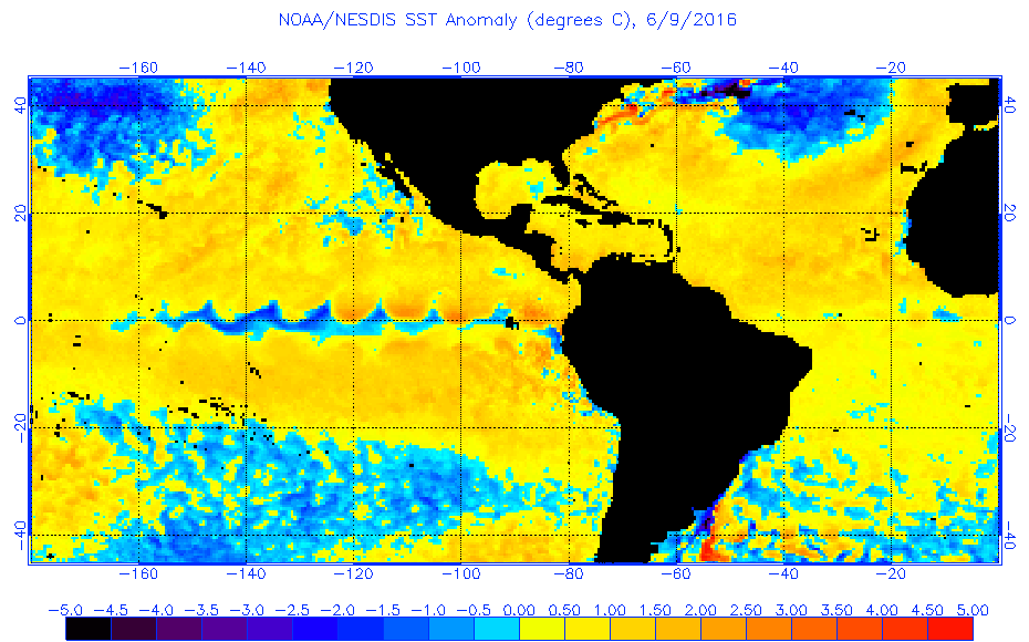
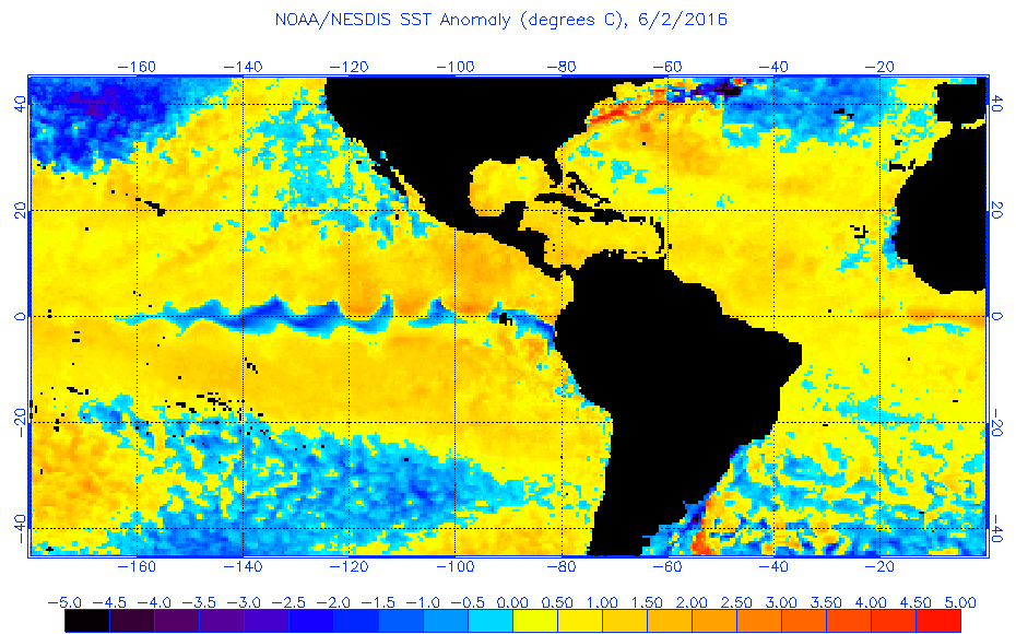
Furthermore you can see the warm up over the past week or so when comparing the map above to the one from June 2nd below.
Furthermore you can see the warm up over the past week or so when comparing the map above to the one from June 2nd below.
0 likes
My posts are not official forecasts. They are just my opinion and may or may not be backed by sound meteorological data. They are NOT endorsed by any professional institution or storm2k.org. For official information, please refer to the NHC and NWS products.
-
WPBWeather

- S2K Supporter
- Posts: 535
- Age: 67
- Joined: Thu Jul 18, 2013 12:33 pm
Re: 2016 indicators: Instability / SST's / MSLP / Steering / Sal
SFLcane wrote:It's become rather confusing/Annoying to whether Atlantic ssts are warming or cooling. Phil k on Twitter today posting tropical Atlantic has cooled significantly while other NOAA sites say it's warmed. What gives
They measure two different locations. Phil K uses the Gray Box. Others use Kaplan Box. One is cooler, the other is warmer. No consensus in the Pro Met community as to which one is better. Time will tell.
0 likes
-
WPBWeather
- S2K Supporter
- Posts: 535
- Age: 67
- Joined: Thu Jul 18, 2013 12:33 pm
Re: 2016 indicators: Instability / SST's / MSLP / Steering / Sal
WPBWeather wrote:SFLcane wrote:It's become rather confusing/Annoying to whether Atlantic ssts are warming or cooling. Phil k on Twitter today posting tropical Atlantic has cooled significantly while other NOAA sites say it's warmed. What gives
They measure two different locations. Phil K uses the Gray Box. Others use Kaplan Box. One is cooler, the other is warmer. No consensus in the Pro Met community as to which one is better. Time will tell.
Hey. I just hit 400!
0 likes
-
SFLcane
- S2K Supporter
- Posts: 10281
- Age: 48
- Joined: Sat Jun 05, 2010 1:44 pm
- Location: Lake Worth Florida
Re: 2016 indicators: Instability / SST's / MSLP / Steering / Sal
Well ice age is back per Phil k...don't think I've ever seen such disparity. Confusing

0 likes

Re: 2016 indicators: Instability / SST's / MSLP / Steering / Sal
Phil K has been very cold biased when it comes to the tropical Atlantic, I have lost count how many times he has posted every time the there's some cooling but at the end the tropical Atlantic does not cools down that much and returns to warm phase.
0 likes
-
Yellow Evan
- Professional-Met
- Posts: 16232
- Age: 27
- Joined: Fri Jul 15, 2011 12:48 pm
- Location: Henderson, Nevada/Honolulu, HI
- Contact:
Re: 2016 indicators: Instability / SST's / MSLP / Steering / Sal
WPBWeather wrote:SFLcane wrote:It's become rather confusing/Annoying to whether Atlantic ssts are warming or cooling. Phil k on Twitter today posting tropical Atlantic has cooled significantly while other NOAA sites say it's warmed. What gives
They measure two different locations. Phil K uses the Gray Box. Others use Kaplan Box. One is cooler, the other is warmer. No consensus in the Pro Met community as to which one is better. Time will tell.
Where are the Gray and Kaplan Box located?
0 likes
-
stormwise
Re: 2016 indicators: Instability / SST's / MSLP / Steering / Sal
One thing that stands out on EC models is the retreat of the jet looks nina. Big ull feature there non tropical.
https://i.imgsafe.org/b72ea778ad.png
https://i.imgsafe.org/b72ea778ad.png
0 likes
-
WPBWeather
- S2K Supporter
- Posts: 535
- Age: 67
- Joined: Thu Jul 18, 2013 12:33 pm
Re: 2016 indicators: Instability / SST's / MSLP / Steering / Sal
Yellow Evan wrote:WPBWeather wrote:SFLcane wrote:It's become rather confusing/Annoying to whether Atlantic ssts are warming or cooling. Phil k on Twitter today posting tropical Atlantic has cooled significantly while other NOAA sites say it's warmed. What gives
They measure two different locations. Phil K uses the Gray Box. Others use Kaplan Box. One is cooler, the other is warmer. No consensus in the Pro Met community as to which one is better. Time will tell.
Where are the Gray and Kaplan Box located?
Good point. They are really different scales measuring the same thing: the AMO in the ATL. The Klotzbach-Gray method, which is different from the long standing Kaplan AMO method, has a negative AMO (cooler) for this year. Kaplan is neutral to warm-- or not negative for this year. The SST measure differences depend upon which method is being used.
0 likes
-
Yellow Evan
- Professional-Met
- Posts: 16232
- Age: 27
- Joined: Fri Jul 15, 2011 12:48 pm
- Location: Henderson, Nevada/Honolulu, HI
- Contact:
Re: 2016 indicators: Instability / SST's / MSLP / Steering / Sal
WPBWeather wrote:Good point. They are really different scales measuring the same thing: the AMO in the ATL. The Klotzbach-Gray method, which is different from the long standing Kaplan AMO method, has a negative AMO (cooler) for this year. Kaplan is neutral to warm-- or not negative for this year. The SST measure differences depend upon which method is being used.
This makes sense, since to me the current ATL SST configuration looks fairly close to zero or slightly negative, since the warmest SST anomalies are in the subtropics, not the tropics.
0 likes
Who is online
Users browsing this forum: No registered users and 100 guests