https://twitter.com/CycloforumsPR/status/757198604968734722
2016 Global Model Runs Discussion (Out to Day 16)
Moderator: S2k Moderators
Forum rules

The posts in this forum are NOT official forecasts and should not be used as such. They are just the opinion of the poster and may or may not be backed by sound meteorological data. They are NOT endorsed by any professional institution or STORM2K. For official information, please refer to products from the National Hurricane Center and National Weather Service.
-
cycloneye

- Admin

- Posts: 149389
- Age: 69
- Joined: Thu Oct 10, 2002 10:54 am
- Location: San Juan, Puerto Rico
Re: 2016 Global Model Runs Discussion (Out to Day 16)
Gif of 06z GFS run.By the way,this is a group in Puerto Rico that has a twitter account and I am part of it. 
https://twitter.com/CycloforumsPR/status/757198604968734722
https://twitter.com/CycloforumsPR/status/757198604968734722
0 likes
Visit the Caribbean-Central America Weather Thread where you can find at first post web cams,radars
and observations from Caribbean basin members Click Here
and observations from Caribbean basin members Click Here


Re: 2016 Global Model Runs Discussion (Out to Day 16)
cycloneye wrote:Gif of 06z GFS run.By the way,this is a group in Puerto Rico that has a twitter account and I am part of it.
https://twitter.com/CycloforumsPR/status/757198604968734722
The Atlantic comes alive on that run with the wave strengthening close to the Southeast coast and a Caribbean rider. Plus low pressures and robust waves in the MDR.
http://www.tropicaltidbits.com/analysis ... _us_45.png
Interesting that the Euro showed the wave too yesterday close to home.
0 likes
The posts or stuff said are NOT an official forecast. Please look to the NHC and NWS for official forecasts and products.
Floyd-1999, Frances-2004, Jeanne-2004, Fay-2008, Beryl-2012, Debby-2012, Colin-2016, Hermine-2016, Julia-2016, Matthew-2016, Irma-2017, Elsa-2021, Idalia-2023, Debby-2024, Helene-2024.
Go Gators! Go Jags!
Floyd-1999, Frances-2004, Jeanne-2004, Fay-2008, Beryl-2012, Debby-2012, Colin-2016, Hermine-2016, Julia-2016, Matthew-2016, Irma-2017, Elsa-2021, Idalia-2023, Debby-2024, Helene-2024.
Go Gators! Go Jags!
Re: 2016 Global Model Runs Discussion (Out to Day 16)
http://i.imgur.com/SGhgiLa.jpg
Blobzilla?
Blobzilla?
0 likes
The posts or stuff said are NOT an official forecast. Please look to the NHC and NWS for official forecasts and products.
Floyd-1999, Frances-2004, Jeanne-2004, Fay-2008, Beryl-2012, Debby-2012, Colin-2016, Hermine-2016, Julia-2016, Matthew-2016, Irma-2017, Elsa-2021, Idalia-2023, Debby-2024, Helene-2024.
Go Gators! Go Jags!
Floyd-1999, Frances-2004, Jeanne-2004, Fay-2008, Beryl-2012, Debby-2012, Colin-2016, Hermine-2016, Julia-2016, Matthew-2016, Irma-2017, Elsa-2021, Idalia-2023, Debby-2024, Helene-2024.
Go Gators! Go Jags!
-
srainhoutx

- S2K Supporter

- Posts: 6919
- Age: 68
- Joined: Sun Jan 14, 2007 11:34 am
- Location: Haywood County, NC
- Contact:
Re: 2016 Global Model Runs Discussion (Out to Day 16)
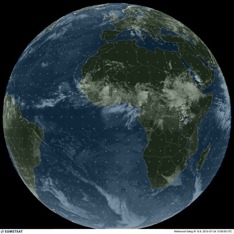
Looking at Meteosat full disk imagery yesterday and today, we can see the vigorous waves moving across Africa.
Metosat Yesterday:

Meteosat Today:
Metosat Yesterday:
Meteosat Today:
0 likes
Carla/Alicia/Jerry(In The Eye)/Michelle/Charley/Ivan/Dennis/Katrina/Rita/Wilma/Ike/Harvey
Member: National Weather Association
Wx Infinity Forums
http://wxinfinity.com/index.php
Facebook.com/WeatherInfinity
Twitter @WeatherInfinity
Member: National Weather Association
Wx Infinity Forums
http://wxinfinity.com/index.php
Facebook.com/WeatherInfinity
Twitter @WeatherInfinity
-
tarheelprogrammer

- S2K Supporter
- Posts: 1793
- Joined: Mon Mar 28, 2016 9:25 pm
- Location: Raleigh, NC area (Garner, NC)
Re: 2016 Global Model Runs Discussion (Out to Day 16)
One thing of note is the 06z GFS shows less shear. This could be problematic if it were to stay that way.
Also, the wave the GFS develops and sends to the EC is the same wave I think or one that comes off of Africa around 42 hours from now.
Also, the wave the GFS develops and sends to the EC is the same wave I think or one that comes off of Africa around 42 hours from now.
1 likes
My posts are not official forecasts. They are just my opinion and may or may not be backed by sound meteorological data. They are NOT endorsed by any professional institution or storm2k.org. For official information, please refer to the NHC and NWS products.
-
TheStormExpert
Re: 2016 Global Model Runs Discussion (Out to Day 16)

1 likes
-
Hurricaneman

- Category 5

- Posts: 7404
- Age: 45
- Joined: Tue Aug 31, 2004 3:24 pm
- Location: central florida
Re: 2016 Global Model Runs Discussion (Out to Day 16)
That wave over Nigeria needs to be watched as it has that looks for development which the GFS does in the Caribbean and even the one over Senegal too as it has it going in to the Bahamas and possibly close to the east coast on the GFS and even the 12zEuro showed that too
The posts in this forum are NOT official forecast and should not be used as such. They are just the opinion of the poster and may or may not be backed by sound meteorological data. They are NOT endorsed by any professional institution or STORM2K. For official information, please refer to products from the National Hurricane Center and National Weather Service
The posts in this forum are NOT official forecast and should not be used as such. They are just the opinion of the poster and may or may not be backed by sound meteorological data. They are NOT endorsed by any professional institution or STORM2K. For official information, please refer to products from the National Hurricane Center and National Weather Service
1 likes
-
tarheelprogrammer
- S2K Supporter
- Posts: 1793
- Joined: Mon Mar 28, 2016 9:25 pm
- Location: Raleigh, NC area (Garner, NC)
Re: 2016 Global Model Runs Discussion (Out to Day 16)
12z GFS drops EC storm. Thank God. 
0 likes
My posts are not official forecasts. They are just my opinion and may or may not be backed by sound meteorological data. They are NOT endorsed by any professional institution or storm2k.org. For official information, please refer to the NHC and NWS products.
-
ninel conde
Re: 2016 Global Model Runs Discussion (Out to Day 16)
tarheelprogrammer wrote:12z GFS drops EC storm. Thank God.
I think we will see this alot. GFS showing storms while the EURO shows pressures quite high in the same area. Need both models to show a well developed storm in roughly the same place and time to get interested.
1 likes
-
tarheelprogrammer
- S2K Supporter
- Posts: 1793
- Joined: Mon Mar 28, 2016 9:25 pm
- Location: Raleigh, NC area (Garner, NC)
Re: 2016 Global Model Runs Discussion (Out to Day 16)
ninel conde wrote:tarheelprogrammer wrote:12z GFS drops EC storm. Thank God.
I think we will see this alot. GFS showing storms while the EURO shows pressures quite high in the same area. Need both models to show a well developed storm in roughly the same place and time to get interested.
Yeah GFS looks like it may keep the Atlantic quiet again. LMAO that model flip flops more than any of the other models. At least in my opinion.
0 likes
My posts are not official forecasts. They are just my opinion and may or may not be backed by sound meteorological data. They are NOT endorsed by any professional institution or storm2k.org. For official information, please refer to the NHC and NWS products.


Re: 2016 Global Model Runs Discussion (Out to Day 16)
Counting about 8/51 EPS members showing development of that first wave, with half ending up in the Gulf and half off the East Coast.
2 likes
-
tarheelprogrammer
- S2K Supporter
- Posts: 1793
- Joined: Mon Mar 28, 2016 9:25 pm
- Location: Raleigh, NC area (Garner, NC)
Re: 2016 Global Model Runs Discussion (Out to Day 16)
Siker wrote:Counting about 8/51 EPS members showing development of that first wave, with half ending up in the Gulf and half off the East Coast.
More than the runs before correct?
0 likes
My posts are not official forecasts. They are just my opinion and may or may not be backed by sound meteorological data. They are NOT endorsed by any professional institution or storm2k.org. For official information, please refer to the NHC and NWS products.
-
gatorcane

- S2K Supporter
- Posts: 23708
- Age: 48
- Joined: Sun Mar 13, 2005 3:54 pm
- Location: Boca Raton, FL
Re: 2016 Global Model Runs Discussion (Out to Day 16)
New GFS continues to show more storms for the EPAC. Those looking for development would want to look there not the Atlantic for the time being.
1 likes
Re: 2016 Global Model Runs Discussion (Out to Day 16)
gatorcane wrote:New GFS continues to show more storms for the EPAC. Those looking for development would want to look there not the Atlantic for the time being.
What about the other models? Just wondering.
1 likes
The posts or stuff said are NOT an official forecast. Please look to the NHC and NWS for official forecasts and products.
Floyd-1999, Frances-2004, Jeanne-2004, Fay-2008, Beryl-2012, Debby-2012, Colin-2016, Hermine-2016, Julia-2016, Matthew-2016, Irma-2017, Elsa-2021, Idalia-2023, Debby-2024, Helene-2024.
Go Gators! Go Jags!
Floyd-1999, Frances-2004, Jeanne-2004, Fay-2008, Beryl-2012, Debby-2012, Colin-2016, Hermine-2016, Julia-2016, Matthew-2016, Irma-2017, Elsa-2021, Idalia-2023, Debby-2024, Helene-2024.
Go Gators! Go Jags!
-
Yellow Evan

- Professional-Met

- Posts: 16232
- Age: 27
- Joined: Fri Jul 15, 2011 12:48 pm
- Location: Henderson, Nevada/Honolulu, HI
- Contact:
Re: 2016 Global Model Runs Discussion (Out to Day 16)
JaxGator wrote:gatorcane wrote:New GFS continues to show more storms for the EPAC. Those looking for development would want to look there not the Atlantic for the time being.
What about the other models? Just wondering.
ECMWF has a storm around day 9 in the EPAC.
1 likes
-
gatorcane
- S2K Supporter
- Posts: 23708
- Age: 48
- Joined: Sun Mar 13, 2005 3:54 pm
- Location: Boca Raton, FL
Re: 2016 Global Model Runs Discussion (Out to Day 16)
JaxGator wrote:gatorcane wrote:New GFS continues to show more storms for the EPAC. Those looking for development would want to look there not the Atlantic for the time being.
What about the other models? Just wondering.
The CMC is finally showing something in the long-range in the far eastern Atlantic. The ECMWF did have something, albeit weak in the long-range east of the Bahamas. What this is telling me is that global models are starting to detect possibly somewhat more favorable (still not great) conditions across the Atlantic out in the long-range which fits nicely with climatology (i.e. what one would expect) for early August. The models do agree the EPAC is where the great conditions should be at for the time being.
Last edited by gatorcane on Sun Jul 24, 2016 12:51 pm, edited 1 time in total.
2 likes

Re: 2016 Global Model Runs Discussion (Out to Day 16)
We're starting to see the changes in the models. GFS is producing a storm on some runs. Seeing a little more activity from the Euro ensembles. It's almost August and the models are starting to indicate this.
5 likes

Re: 2016 Global Model Runs Discussion (Out to Day 16)
RL3AO wrote:We're starting to see the changes in the models. GFS is producing a storm on some runs. Seeing a little more activity from the Euro ensembles. It's almost August and the models are starting to indicate this.
Exactly, it really is more about watching "the tea leaves" rather than biting on any particular model - for any particular model run. Even having several model run consistancy along with some corroborating alternate model support, doesnt literally mean "a tropical cyclone" will definatly exist at that given forecast time frame (or even at all). I enjoy model watching but in the context of them indicating that certain dynamics are appearing favorable for development to occur. Seems to me that many continue to over-simplify the function and capable analysis of long range modeling, and then simply apply current regional or global conditions to rationalize their own perception whether long range forecasts may or may not ever validate.
1 likes
Andy D
(For official information, please refer to the NHC and NWS products.)
(For official information, please refer to the NHC and NWS products.)

Re: 2016 Global Model Runs Discussion (Out to Day 16)
ninel conde wrote:tarheelprogrammer wrote:06z GFS with a hurricane hit in eastern NC. Ensemble members showing OTS , EC, or GOM possibilities. No other model support. Hopefully a phantom storm.
If at 12z both the gfs and euro show a well developed SURFACE low then its time to worry a bit. JB hasnt tweeted anything about it.
Well lately JB seems bored with the weather. He mostly tweets about politics now much to my dismay.
0 likes
Re: 2016 Global Model Runs Discussion (Out to Day 16)
Just a model run for the E-Pac but shear is hard to forecast. This may or may not happen at all.
http://www.tropicaltidbits.com/analysis ... pac_12.png
http://www.tropicaltidbits.com/analysis ... pac_12.png
0 likes
The posts or stuff said are NOT an official forecast. Please look to the NHC and NWS for official forecasts and products.
Floyd-1999, Frances-2004, Jeanne-2004, Fay-2008, Beryl-2012, Debby-2012, Colin-2016, Hermine-2016, Julia-2016, Matthew-2016, Irma-2017, Elsa-2021, Idalia-2023, Debby-2024, Helene-2024.
Go Gators! Go Jags!
Floyd-1999, Frances-2004, Jeanne-2004, Fay-2008, Beryl-2012, Debby-2012, Colin-2016, Hermine-2016, Julia-2016, Matthew-2016, Irma-2017, Elsa-2021, Idalia-2023, Debby-2024, Helene-2024.
Go Gators! Go Jags!
Who is online
Users browsing this forum: Google [Bot] and 46 guests