2016 Global Model Runs Discussion (Out to Day 16)

This is the general tropical discussion area. Anyone can take their shot at predicting a storms path.

Moderator: S2k Moderators

Forum rules

The posts in this forum are NOT official forecasts and should not be used as such. They are just the opinion of the poster and may or may not be backed by sound meteorological data. They are NOT endorsed by any professional institution or STORM2K. For official information, please refer to products from the National Hurricane Center and National Weather Service.

Help Support Storm2K
Message
Author
User avatar
Hammy
Category 5
Category 5
Posts: 5849
Age: 41
Joined: Fri May 25, 2012 5:25 pm
Contact:

Re: 2016 Global Model Runs Discussion (Out to Day 16)

#1141 Postby Hammy » Mon Jul 25, 2016 3:04 am

chaser1 wrote:0Z GFS showing lower surface pressures in the SW Carib. than recent runs. Also showing another non tropical low quickly turning tropical off the Conus East coast in the 200+ hr. range. Trending slowly towards the light switch about to be turned on.


Euro is indicating something could develop headed towards the Bahamas in about a week's time.
0 likes   
The above post is not official and should not be used as such. It is the opinion of the poster and may or may not be backed by sound meteorological data. It is not endorsed by any professional institution or storm2k.org. For official information, please refer to the NHC and NWS products.

USTropics
Professional-Met
Professional-Met
Posts: 2651
Joined: Sun Aug 12, 2007 3:45 am
Location: Florida State University

Re: 2016 Global Model Runs Discussion (Out to Day 16)

#1142 Postby USTropics » Mon Jul 25, 2016 3:45 am

I haven't seen this mentioned yet on Storm2k but apparently the NHC has been following the wave that the GFS model was initially developing as it exited Africa (they've labeled it 50L).

Source: ftp://ftp.nhc.noaa.gov/atcf/btk/bal502016.dat

This is most likely experimental but the first time I've seen it.
0 likes   

ninel conde

Re: 2016 Global Model Runs Discussion (Out to Day 16)

#1143 Postby ninel conde » Mon Jul 25, 2016 6:20 am

Hammy wrote:
chaser1 wrote:0Z GFS showing lower surface pressures in the SW Carib. than recent runs. Also showing another non tropical low quickly turning tropical off the Conus East coast in the 200+ hr. range. Trending slowly towards the light switch about to be turned on.


Euro is indicating something could develop headed towards the Bahamas in about a week's time.


Image

Dont see anything. pressue rather high in sw atl.
0 likes   

User avatar
NDG
S2K Supporter
S2K Supporter
Posts: 15446
Joined: Sun Jul 09, 2006 10:14 pm
Location: Orlando, FL

Re: 2016 Global Model Runs Discussion (Out to Day 16)

#1144 Postby NDG » Mon Jul 25, 2016 6:30 am

As mentioned by some, 0z Euro shows a strong tropical wave with possible weak development as it approaches the Bahamas.
A shows a strong mid level ridge north of it preventing it from recurving out to sea.

Image
Image
Image
0 likes   

stormwise

Re: 2016 Global Model Runs Discussion (Out to Day 16)

#1145 Postby stormwise » Mon Jul 25, 2016 6:37 am

Not :eek: prefer to see a fish storm, those are basically what the EC ens are showing.
0 likes   

ninel conde

Re: 2016 Global Model Runs Discussion (Out to Day 16)

#1146 Postby ninel conde » Mon Jul 25, 2016 6:49 am

NDG wrote:As mentioned by some, 0z Euro shows a strong tropical wave with possible weak development as it approaches the Bahamas.
A shows a strong mid level ridge north of it preventing it from recurving out to sea.

Image
Image
Image


I see. Thanks for the clarification
0 likes   

User avatar
JaxGator
Category 2
Category 2
Posts: 780
Joined: Sun Jun 12, 2016 3:33 pm
Location: Jacksonville Florida

Re: 2016 Global Model Runs Discussion (Out to Day 16)

#1147 Postby JaxGator » Mon Jul 25, 2016 8:26 am

USTropics wrote:I haven't seen this mentioned yet on Storm2k but apparently the NHC has been following the wave that the GFS model was initially developing as it exited Africa (they've labeled it 50L).

Source: ftp://ftp.nhc.noaa.gov/atcf/btk/bal502016.dat

This is most likely experimental but the first time I've seen it.


https://scontent-mia1-1.xx.fbcdn.net/v/ ... e=58145157
https://scontent-mia1-1.xx.fbcdn.net/v/ ... e=58178CBB

Yeah, don't know what the NHC is doing either but it's cool I guess. And thank you to the members and Mods that helped to answer my question. Y'all's insight is appreciated.
2 likes   
The posts or stuff said are NOT an official forecast. Please look to the NHC and NWS for official forecasts and products.

Floyd-1999, Frances-2004, Jeanne-2004, Fay-2008, Beryl-2012, Debby-2012, Colin-2016, Hermine-2016, Julia-2016, Matthew-2016, Irma-2017, Elsa-2021, Idalia-2023, Debby-2024, Helene-2024.


Go Gators! Go Jags!

User avatar
1900hurricane
Category 5
Category 5
Posts: 6059
Age: 34
Joined: Fri Feb 06, 2015 12:04 pm
Location: Houston, TX
Contact:

Re: 2016 Global Model Runs Discussion (Out to Day 16)

#1148 Postby 1900hurricane » Mon Jul 25, 2016 8:55 am

It's a test invest/storm. The NHC and other various agencies will do them every once and a while.
4 likes   
Contract Meteorologist. TAMU & MSST. Fiercely authentic, one of a kind. We are all given free will, so choose a life meant to be lived. We are the Masters of our own Stories.
Opinions expressed are mine alone.

Follow me on Twitter at @1900hurricane : Read blogs at https://1900hurricane.wordpress.com/

USTropics
Professional-Met
Professional-Met
Posts: 2651
Joined: Sun Aug 12, 2007 3:45 am
Location: Florida State University

Re: 2016 Global Model Runs Discussion (Out to Day 16)

#1149 Postby USTropics » Mon Jul 25, 2016 9:58 am

1900hurricane wrote:It's a test invest/storm. The NHC and other various agencies will do them every once and a while.


To add to this:

  • 1-49 are for actual tropical cyclones
  • 50-69 are reserved for special use
  • 70-79 are for internal use for training purposes
  • 80-89 are for test invests
  • 90-99 are for operational invests

The letter following the number just designates basin (L stands for Atlantic).
3 likes   

User avatar
JaxGator
Category 2
Category 2
Posts: 780
Joined: Sun Jun 12, 2016 3:33 pm
Location: Jacksonville Florida

Re: 2016 Global Model Runs Discussion (Out to Day 16)

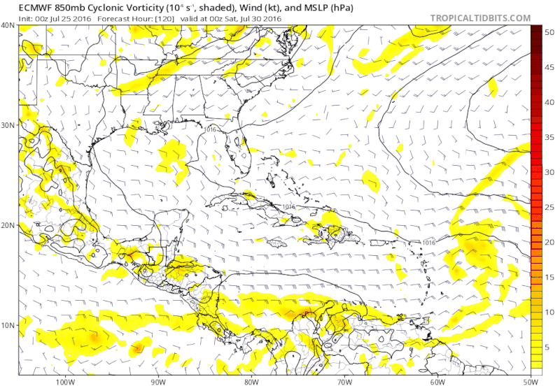
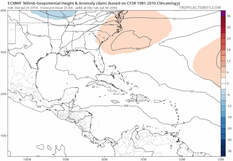
#1150 Postby JaxGator » Mon Jul 25, 2016 10:10 am

ninel conde wrote:
MetroMike wrote:
ninel conde wrote:If at 12z both the gfs and euro show a well developed SURFACE low then its time to worry a bit. JB hasnt tweeted anything about it.

Well lately JB seems bored with the weather. He mostly tweets about politics now much to my dismay.


Its a bad sign when JB cant even find a glimmer of hope in the atlantic.


He said it would probably be quiet in July for the most part. Of course in the tropics, you can be sometimes be caught off guard but imo, we're right on track.
1 likes   
The posts or stuff said are NOT an official forecast. Please look to the NHC and NWS for official forecasts and products.

Floyd-1999, Frances-2004, Jeanne-2004, Fay-2008, Beryl-2012, Debby-2012, Colin-2016, Hermine-2016, Julia-2016, Matthew-2016, Irma-2017, Elsa-2021, Idalia-2023, Debby-2024, Helene-2024.


Go Gators! Go Jags!

User avatar
Blown Away
S2K Supporter
S2K Supporter
Posts: 10146
Joined: Wed May 26, 2004 6:17 am

Re: 2016 Global Model Runs Discussion (Out to Day 16)

#1151 Postby Blown Away » Mon Jul 25, 2016 10:29 am

JaxGator wrote:
ninel conde wrote:
MetroMike wrote:Well lately JB seems bored with the weather. He mostly tweets about politics now much to my dismay.


Its a bad sign when JB cant even find a glimmer of hope in the atlantic.


He said it would probably be quiet in July for the most part. Of course in the tropics, you can be sometimes be caught off guard but imo, we're right on track.

Image

JB geared up to back his "Near Normal" season predictions...
1 likes   
Hurricane Eye Experience: David 79, Irene 99, Frances 04, Jeanne 04, Wilma 05... EYE COMING MY WAY IN 2024…
Hurricane Brush Experience: Andrew 92, Erin 95, Floyd 99, Matthew 16, Irma 17, Ian 22, Nicole 22…

User avatar
tarheelprogrammer
S2K Supporter
S2K Supporter
Posts: 1793
Joined: Mon Mar 28, 2016 9:25 pm
Location: Raleigh, NC area (Garner, NC)

Re: 2016 Global Model Runs Discussion (Out to Day 16)

#1152 Postby tarheelprogrammer » Mon Jul 25, 2016 12:37 pm

Well it looks like the models are continuing with nothing developing and the pattern seems to be stubbornly staying the same as it was in July on these runs now for August. The more these models run the better I feel about me updating my numbers. Seems like the models want to change things to fit the climo but then realize it is not changing at all. Dry air seems to be going no where anytime soon. 8-)

Image
0 likes   
My posts are not official forecasts. They are just my opinion and may or may not be backed by sound meteorological data. They are NOT endorsed by any professional institution or storm2k.org. For official information, please refer to the NHC and NWS products.

User avatar
NDG
S2K Supporter
S2K Supporter
Posts: 15446
Joined: Sun Jul 09, 2006 10:14 pm
Location: Orlando, FL

Re: 2016 Global Model Runs Discussion (Out to Day 16)

#1153 Postby NDG » Mon Jul 25, 2016 1:00 pm

:uarrow: If you think that the GFS's 384 hr forecast will come to fruition or close to it I just hope you are not betting money on it with develpment or no development on it.
1 likes   

tolakram
Admin
Admin
Posts: 20010
Age: 62
Joined: Sun Aug 27, 2006 8:23 pm
Location: Florence, KY (name is Mark)

Re: 2016 Global Model Runs Discussion (Out to Day 16)

#1154 Postby tolakram » Mon Jul 25, 2016 1:05 pm

tarheelprogrammer wrote:Well it looks like the models are continuing with nothing developing and the pattern seems to be stubbornly staying the same as it was in July on these runs now for August. The more these models run the better I feel about me updating my numbers. Seems like the models want to change things to fit the climo but then realize it is not changing at all. Dry air seems to be going no where anytime soon. 8-)


What exactly are you looking at and why?
0 likes   
M a r k
- - - - -
Join us in chat: Storm2K Chatroom Invite. Android and IOS apps also available.

The posts in this forum are NOT official forecasts and should not be used as such. Posts are NOT endorsed by any professional institution or STORM2K.org. For official information and forecasts, please refer to NHC and NWS products.

User avatar
tarheelprogrammer
S2K Supporter
S2K Supporter
Posts: 1793
Joined: Mon Mar 28, 2016 9:25 pm
Location: Raleigh, NC area (Garner, NC)

Re: 2016 Global Model Runs Discussion (Out to Day 16)

#1155 Postby tarheelprogrammer » Mon Jul 25, 2016 1:11 pm

tolakram wrote:
tarheelprogrammer wrote:Well it looks like the models are continuing with nothing developing and the pattern seems to be stubbornly staying the same as it was in July on these runs now for August. The more these models run the better I feel about me updating my numbers. Seems like the models want to change things to fit the climo but then realize it is not changing at all. Dry air seems to be going no where anytime soon. 8-)


What exactly are you looking at and why?


CMC, GFS, and NAVGEM all showing the same set up as July. Looks like increasing shear being added as well. I could be wrong but it is what I am seeing. Steadfast with dry air and shear.
0 likes   
My posts are not official forecasts. They are just my opinion and may or may not be backed by sound meteorological data. They are NOT endorsed by any professional institution or storm2k.org. For official information, please refer to the NHC and NWS products.

ninel conde

Re: 2016 Global Model Runs Discussion (Out to Day 16)

#1156 Postby ninel conde » Mon Jul 25, 2016 1:12 pm

NDG wrote::uarrow: If you think that the GFS's 384 hr forecast will come to fruition or close to it I just hope you are not betting money on it with develpment or no development on it.


Showing no development is far more likely to verify than if it had a well developed cane in a place where it could threaten land south and west of 25
1 likes   

ninel conde

Re: 2016 Global Model Runs Discussion (Out to Day 16)

#1157 Postby ninel conde » Mon Jul 25, 2016 1:14 pm

tarheelprogrammer wrote:Well it looks like the models are continuing with nothing developing and the pattern seems to be stubbornly staying the same as it was in July on these runs now for August. The more these models run the better I feel about me updating my numbers. Seems like the models want to change things to fit the climo but then realize it is not changing at all. Dry air seems to be going no where anytime soon. 8-)

Image


That low over the nw atl, se canada is very persistent. above normal sst's near the US mean nothing as long as that low is there. I know JB talked about the newfoundland wheel awhile back but i see nothing indicating a high will lock in(and i mean lock in, not for 2 days)
1 likes   

Alyono
Professional-Met
Professional-Met
Posts: 6961
Joined: Fri Apr 26, 2013 3:52 pm
Location: Texas Coast

Re: 2016 Global Model Runs Discussion (Out to Day 16)

#1158 Postby Alyono » Mon Jul 25, 2016 1:18 pm

why is anyone surprised that the MDR is dead.

IT WAS SUPPOSED TO BE DEAD THIS YEAR!!! The models are showing a season playing out LIKE IT SHOULD and LIKE THE ANALOGS SAID

Just keep an eye on that persistent trough off of the East Coast and in the northern Gulf. Something will likely develop from that
1 likes   

User avatar
srainhoutx
S2K Supporter
S2K Supporter
Posts: 6919
Age: 67
Joined: Sun Jan 14, 2007 11:34 am
Location: Haywood County, NC
Contact:

Re: 2016 Global Model Runs Discussion (Out to Day 16)

#1159 Postby srainhoutx » Mon Jul 25, 2016 1:21 pm

The Super Ensembles suggest a more favorable pattern across the Western Caribbean and the Western Gulf. Watch for any stalled frontal boundary across the Northern Gulf Coast as well.

Image
0 likes   
Carla/Alicia/Jerry(In The Eye)/Michelle/Charley/Ivan/Dennis/Katrina/Rita/Wilma/Ike/Harvey

Member: National Weather Association
Wx Infinity Forums
http://wxinfinity.com/index.php

Facebook.com/WeatherInfinity
Twitter @WeatherInfinity

ninel conde

Re: 2016 Global Model Runs Discussion (Out to Day 16)

#1160 Postby ninel conde » Mon Jul 25, 2016 1:21 pm

Alyono wrote:why is anyone surprised that the MDR is dead.

IT WAS SUPPOSED TO BE DEAD THIS YEAR!!! The models are showing a season playing out LIKE IT SHOULD and LIKE THE ANALOGS SAID

Just keep an eye on that persistent trough off of the East Coast and in the northern Gulf. Something will likely develop from that


I agree that in this type of season we need to look for systems of non-tropical origin to possibly develop but i also think its highly unlikely to see anything of interest in those areas until a high locks in over the NW ATL. As long as that low dominates the NW ATL anything that might develop in close will be weak, strung out, and swept out quickly NE.
1 likes   


Return to “Talkin' Tropics”

Who is online

Users browsing this forum: AnnularCane, Stratton23 and 60 guests