
2016 WPAC Season
Moderator: S2k Moderators
Forum rules

The posts in this forum are NOT official forecasts and should not be used as such. They are just the opinion of the poster and may or may not be backed by sound meteorological data. They are NOT endorsed by any professional institution or STORM2K. For official information, please refer to products from the National Hurricane Center and National Weather Service.
-
dexterlabio
- Category 5

- Posts: 3518
- Joined: Sat Oct 24, 2009 11:50 pm
Re: 2016 WPAC Season
IMO the Euro has the most believable output. The fewer the spawned storms out of the monsoon trough, the more legit it appears to me.. Although the previous Euro runs are still inconsistent.
The upcoming strong MJO signal in the WPAC is surely making the model guidance to scramble. Interestingly, the MJO pulse is forecasted to stall in the area throughout the last week of August, and I've been reading tweets from pro-mets saying that multiple recurving TC's help in trapping the MJO within Phase 6-7.
The upcoming strong MJO signal in the WPAC is surely making the model guidance to scramble.
0 likes
Personal Forecast Disclaimer:
The posts in this forum are NOT official forecast and should not be used as such. They are just the opinion of the poster and may or may not be backed by sound meteorological data. They are NOT endorsed by any professional institution or storm2k.org. For official information, please refer to the NHC and NWS products.
The posts in this forum are NOT official forecast and should not be used as such. They are just the opinion of the poster and may or may not be backed by sound meteorological data. They are NOT endorsed by any professional institution or storm2k.org. For official information, please refer to the NHC and NWS products.
-
1900hurricane

- Category 5
- Posts: 6063
- Age: 34
- Joined: Fri Feb 06, 2015 12:04 pm
- Location: Houston, TX
- Contact:
Re: 2016 WPAC Season
I'm leaning heavily towards an ECMWF type solution too. It's been consistently showing a believable two or three storms. The GFS has been trending that way too for the latest 12Z, 18Z, and 00Z runs.
0 likes
Contract Meteorologist. TAMU & MSST. Fiercely authentic, one of a kind. We are all given free will, so choose a life meant to be lived. We are the Masters of our own Stories.
Opinions expressed are mine alone.
Follow me on Twitter at @1900hurricane : Read blogs at https://1900hurricane.wordpress.com/
Opinions expressed are mine alone.
Follow me on Twitter at @1900hurricane : Read blogs at https://1900hurricane.wordpress.com/
-
euro6208
Re: 2016 WPAC Season
Typhoon Hunter wrote:ECMWF 00z run interesting. Developing a tropical system around 20N 130E, far enough away from the circulations to the east for it to develop and be steered towards Taiwan by the high over Japan. Reminds me a bit of Sinlaku in 2008.
INVEST 99W
Now tagged as 99W...
0 likes
-
euro6208
-
euro6208
Re: 2016 WPAC Season
JMA on another large system swiping the Marianas bringing renewed rains....

NAVGEM also on board...

NAVGEM also on board...
0 likes
-
euro6208
Re: 2016 WPAC Season


Multiple systems with the strongest run ever at 930mb for P.I sea storm!
0 likes
-
euro6208
Re: 2016 WPAC Season
The GFS runs reminded me alot about 1997...2 Category 5's roaming the basin and brings one of them below 900mb...Agrees with the other models on the P.I storm and brings it over Japan as a Cat 5...

0 likes
-
1900hurricane
- Category 5
- Posts: 6063
- Age: 34
- Joined: Fri Feb 06, 2015 12:04 pm
- Location: Houston, TX
- Contact:
Re: 2016 WPAC Season
euro6208 wrote:Typhoon Hunter wrote:ECMWF 00z run interesting. Developing a tropical system around 20N 130E, far enough away from the circulations to the east for it to develop and be steered towards Taiwan by the high over Japan. Reminds me a bit of Sinlaku in 2008.
INVEST 99W
Now tagged as 99W...
Actually, this one is the ones the models were half-heartedly developing from the MCS that came off the Chinese coast. That modeled system is coming from the reverse-oriented monsoon trough that is currently in the early stages of setting up.

0 likes
Contract Meteorologist. TAMU & MSST. Fiercely authentic, one of a kind. We are all given free will, so choose a life meant to be lived. We are the Masters of our own Stories.
Opinions expressed are mine alone.
Follow me on Twitter at @1900hurricane : Read blogs at https://1900hurricane.wordpress.com/
Opinions expressed are mine alone.
Follow me on Twitter at @1900hurricane : Read blogs at https://1900hurricane.wordpress.com/
Re: 2016 WPAC Season
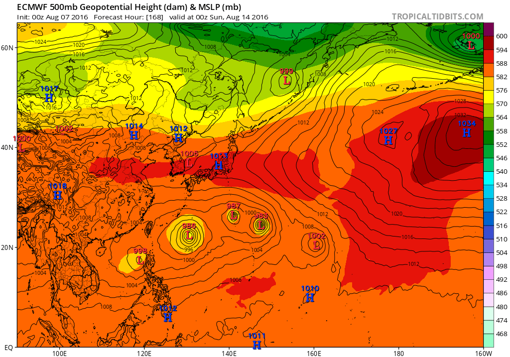
Even the Euro is now showing something insane A lot of Fujiwhara to watch.
0 likes
Personal Forecast Disclaimer:
The posts in this forum are NOT official forecast and should not be used as such. They are just the opinion of the poster and may or may not be backed by sound meteorological data. They are NOT endorsed by any professional institution or storm2k.org. For official information, please refer to RSMC and NWS products.
The posts in this forum are NOT official forecast and should not be used as such. They are just the opinion of the poster and may or may not be backed by sound meteorological data. They are NOT endorsed by any professional institution or storm2k.org. For official information, please refer to RSMC and NWS products.
-
Typhoon Hunter
- WesternPacificWeather.com

- Posts: 1222
- Joined: Wed Oct 11, 2006 11:37 am
- Location: Tokyo
- Contact:
Re: 2016 WPAC Season
NotoSans wrote:Even the Euro is now showing something insane
No idea what to make of that run - never seen something so ridiculous! I guess one or two dominant circulations will win out (with potential for some sort of interaction) and develop. Right now the models are urghhh
0 likes

-
stormwise
Re: 2016 WPAC Season
looks a monsoon gyre,they are typically the locus of multiple tropical cyclone formations.
0 likes
-
euro6208
Re: 2016 WPAC Season
Quite an MJO moving over the area and possibly might stay and strengthen at the same time for a longer period of time. Time to bring out the Umbrellas...


Combine this with a ridicous Monsoon Trough setup near 20N...It's all hell...
Combine this with a ridicous Monsoon Trough setup near 20N...It's all hell...
0 likes
-
dexterlabio
- Category 5
- Posts: 3518
- Joined: Sat Oct 24, 2009 11:50 pm
Re: 2016 WPAC Season
The ridiculous model outputs even from the most reputable global models make the coming weeks more interesting, IMO. We just know that something's gonna form eventually, but everything else is up in the air...
0 likes
Personal Forecast Disclaimer:
The posts in this forum are NOT official forecast and should not be used as such. They are just the opinion of the poster and may or may not be backed by sound meteorological data. They are NOT endorsed by any professional institution or storm2k.org. For official information, please refer to the NHC and NWS products.
The posts in this forum are NOT official forecast and should not be used as such. They are just the opinion of the poster and may or may not be backed by sound meteorological data. They are NOT endorsed by any professional institution or storm2k.org. For official information, please refer to the NHC and NWS products.
-
euro6208
Re: 2016 WPAC Season
Typhoon Hunter wrote:NotoSans wrote:Even the Euro is now showing something insane
No idea what to make of that run - never seen something so ridiculous! I guess one or two dominant circulations will win out (with potential for some sort of interaction) and develop. Right now the models are urghhh

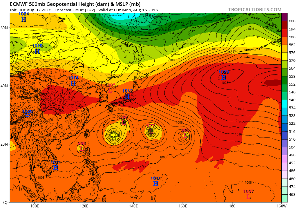
Crazy that it develops 4 typhoons in just 2 days with 2 of them swallowing the other 2 typhoons and becoming bigger...There's another near Luzon...
0 likes
-
euro6208
Re: 2016 WPAC Season
euro6208 wrote:Typhoon Hunter wrote:NotoSans wrote:Even the Euro is now showing something insane
No idea what to make of that run - never seen something so ridiculous! I guess one or two dominant circulations will win out (with potential for some sort of interaction) and develop. Right now the models are urghhh
Crazy that it develops 4 typhoons in just 2 days with 2 of them swallowing the other 2 typhoons and becoming bigger...There's another near Luzon...
GFS much more calm in 06Z run...
0 likes
-
dexterlabio
- Category 5
- Posts: 3518
- Joined: Sat Oct 24, 2009 11:50 pm
Re: 2016 WPAC Season
My amateur eyes tells me that the area south of 20N and east of 130E is invest-worthy..
0 likes
Personal Forecast Disclaimer:
The posts in this forum are NOT official forecast and should not be used as such. They are just the opinion of the poster and may or may not be backed by sound meteorological data. They are NOT endorsed by any professional institution or storm2k.org. For official information, please refer to the NHC and NWS products.
The posts in this forum are NOT official forecast and should not be used as such. They are just the opinion of the poster and may or may not be backed by sound meteorological data. They are NOT endorsed by any professional institution or storm2k.org. For official information, please refer to the NHC and NWS products.
-
euro6208
Re: 2016 WPAC Season
The models still sensing a huge outbreak emanating from the robust monsoon trough over the area...


0 likes
-
euro6208
Re: 2016 WPAC Season
dexterlabio wrote:My amateur eyes tells me that the area south of 20N and east of 130E is invest-worthy..
Now an invest...
INVEST 92W
0 likes
Who is online
Users browsing this forum: Google [Bot] and 120 guests