Wave between Bermuda and Greater Antilles
Moderator: S2k Moderators
Forum rules

The posts in this forum are NOT official forecasts and should not be used as such. They are just the opinion of the poster and may or may not be backed by sound meteorological data. They are NOT endorsed by any professional institution or STORM2K. For official information, please refer to products from the National Hurricane Center and National Weather Service.
Re: Wave between Bermuda and Greater Antilles
0 likes
Personal Forecast Disclaimer:
The posts in this forum are NOT official forecasts and should not be used as such. They are just the opinion of the poster and may or may not be backed by sound meteorological data. They are NOT endorsed by any professional institution or storm2k.org. For official information, please refer to the NHC and NWS products.
The posts in this forum are NOT official forecasts and should not be used as such. They are just the opinion of the poster and may or may not be backed by sound meteorological data. They are NOT endorsed by any professional institution or storm2k.org. For official information, please refer to the NHC and NWS products.
-
floridasun78
- Category 5

- Posts: 3755
- Joined: Sun May 17, 2009 10:16 pm
- Location: miami fl
Re: Wave between Bermuda and Greater Antilles
LarryWx wrote::uarrow: I still think that's the way to go IF there is going to be an actual US threat. I don't see a FL/GA & likely not a SC threat. NC, especially OB, appears at risk, however, though it could recurve east of there.
i think too early to say what new run models will show we need see how models show by monday
0 likes
-
CrazyC83
- Professional-Met

- Posts: 34315
- Joined: Tue Mar 07, 2006 11:57 pm
- Location: Deep South, for the first time!
Re: Wave between Bermuda and Greater Antilles
Could the Gulf low create a Fujiwhara situation which forces this low westward into the east coast? Similar to what nearly happened with Joaquin if it hadn't RI'd near the Bahamas.
0 likes
-
OuterBanker
- S2K Supporter

- Posts: 1761
- Joined: Wed Feb 26, 2003 10:53 am
- Location: Nags Head, NC
- Contact:
Re: Wave between Bermuda and Greater Antilles
I guess the big question will be will this or gulf be the wife of Shrek.
1 likes


-
cycloneye

- Admin

- Posts: 149451
- Age: 69
- Joined: Thu Oct 10, 2002 10:54 am
- Location: San Juan, Puerto Rico
Re: Wave between Bermuda and Greater Antilles
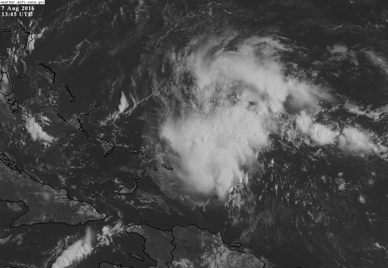
A tropical wave is producing disorganized cloudiness and showers
just north of Puerto Rico, eastern Hispaniola, and adjacent
Atlantic waters. This activity is expected to move northwestward
and northward, and an area of low pressure could form in the
Atlantic Ocean between Florida and Bermuda by Tuesday.
* Formation chance through 48 hours...low...10 percent
* Formation chance through 5 days...low...20 percent
0 likes
Visit the Caribbean-Central America Weather Thread where you can find at first post web cams,radars
and observations from Caribbean basin members Click Here
and observations from Caribbean basin members Click Here
-
floridasun78
- Category 5
- Posts: 3755
- Joined: Sun May 17, 2009 10:16 pm
- Location: miami fl
Re: Wave between Bermuda and Greater Antilles
looking models runs dont show any thing coming out this area north of PR yet
0 likes
-
cycloneye
- Admin
- Posts: 149451
- Age: 69
- Joined: Thu Oct 10, 2002 10:54 am
- Location: San Juan, Puerto Rico
Re: Wave between Bermuda and Greater Antilles
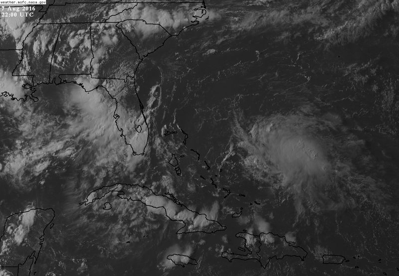
Disorganized cloudiness and showers continue over the western
Atlantic Ocean located near the southeastern Bahamas. Any
development of this system is expected to be slow to occur during
the next several days while it moves northwestward and then
northward, nearly midway between Florida and Bermuda by Tuesday.
* Formation chance through 48 hours...low...10 percent
* Formation chance through 5 days...low...20 percent
0 likes
Visit the Caribbean-Central America Weather Thread where you can find at first post web cams,radars
and observations from Caribbean basin members Click Here
and observations from Caribbean basin members Click Here

Re: Wave between Bermuda and Greater Antilles
This tropical wave is looking better this morning with a noticeable vorticity at h70, is staying far enough from the ULL over the NW Bahamas for it not be sheared away.
0z Euro shows vorticity becoming better defined at h85 over the next 72-96 hrs east of FL with better UL conditions but forecasts UL winds to become unfavorable by the end of the week.
0z Euro shows vorticity becoming better defined at h85 over the next 72-96 hrs east of FL with better UL conditions but forecasts UL winds to become unfavorable by the end of the week.
0 likes

Re: Wave between Bermuda and Greater Antilles
I'm surprised this is still 10%/20%. I think the 2pm update will bring the percentages up for both disturbances.
0 likes
Igor 2010, Sandy 2012, Fay 2014, Gonzalo 2014, Joaquin 2015, Nicole 2016, Humberto 2019, Imelda 2025
I am only a tropical weather enthusiast. My predictions are not official and may or may not be backed by sound meteorological data. For official information, please refer to the NHC and NWS products.
I am only a tropical weather enthusiast. My predictions are not official and may or may not be backed by sound meteorological data. For official information, please refer to the NHC and NWS products.
-
cycloneye
- Admin
- Posts: 149451
- Age: 69
- Joined: Thu Oct 10, 2002 10:54 am
- Location: San Juan, Puerto Rico
Re: Wave between Bermuda and Greater Antilles
Development less likely.
Showers and thunderstorms continue just to the northeast of
the southeastern Bahamas, but show no signs of organization.
Development, if any, of this disturbed weather is becoming less
likely while it moves northwestward and then northward off of the
coast of the southeastern United States.
* Formation chance through 48 hours...low...10 percent
* Formation chance through 5 days...low...20 percent
0 likes
Visit the Caribbean-Central America Weather Thread where you can find at first post web cams,radars
and observations from Caribbean basin members Click Here
and observations from Caribbean basin members Click Here
Re: Wave between Bermuda and Greater Antilles
Really surprised nobody has been talking about this TW, it has developed a vigorous MLC at h70 this afternoon and 12z Euro closed off a weak surface low in a couple of days, but eventually it still shows that the UL winds will not be the best for further development, but it has best chances for development in the Atlantic basin right now. IMO.
0 likes
-
floridasun78
- Category 5
- Posts: 3755
- Joined: Sun May 17, 2009 10:16 pm
- Location: miami fl
Re: Wave between Bermuda and Greater Antilles
look like Bermuda need watch it
The posts in this forum are NOT official forecast and should not be used as such
0 likes
-
TheStormExpert
Re: Wave between Bermuda and Greater Antilles
Still at 10/20% in the 8pm TWO.
An area of disturbed weather is located a few hundred miles east of
the central Bahamas. Although the associated showers and
thunderstorms have been persistent, there are no signs of a surface
circulation. Development, if any, of this disturbance is expected
to be slow to occur while it moves generally northward off of the
coast of the southeastern United States.
* Formation chance through 48 hours...low...10 percent
* Formation chance through 5 days...low...20 percent
0 likes
-
floridasun78
- Category 5
- Posts: 3755
- Joined: Sun May 17, 2009 10:16 pm
- Location: miami fl
-
TheStormExpert
Re: Wave between Bermuda and Greater Antilles
It's over.
TROPICAL WEATHER OUTLOOK
NWS NATIONAL HURRICANE CENTER MIAMI FL
800 AM EDT MON AUG 8 2016
For the North Atlantic...Caribbean Sea and the Gulf of Mexico:
Disorganized cloudiness and showers located a few hundred miles northeast of the Bahamas are associated with a mid-level trough of low pressure. There are no signs of a surface circulation, and development of this system has become unlikely as the trough moves
generally northward off of the coast of the southeastern United States.
* Formation chance through 48 hours...low...near 0 percent
* Formation chance through 5 days...low...near 0 percent
$$
Forecaster Kimberlain
0 likes
-
OuterBanker
- S2K Supporter
- Posts: 1761
- Joined: Wed Feb 26, 2003 10:53 am
- Location: Nags Head, NC
- Contact:
Re: Wave between Bermuda and Greater Antilles
Poof! Apparently ripped apart by the semi permanant ull in the Bahamas (quite obvious in the wv loop).
1 likes
Re: Wave between Bermuda and Greater Antilles
The wave is no longer on the NHC weather outlook. Looks like further development is unlikely.
0 likes
Igor 2010, Sandy 2012, Fay 2014, Gonzalo 2014, Joaquin 2015, Nicole 2016, Humberto 2019, Imelda 2025
I am only a tropical weather enthusiast. My predictions are not official and may or may not be backed by sound meteorological data. For official information, please refer to the NHC and NWS products.
I am only a tropical weather enthusiast. My predictions are not official and may or may not be backed by sound meteorological data. For official information, please refer to the NHC and NWS products.
-
floridasun78
- Category 5
- Posts: 3755
- Joined: Sun May 17, 2009 10:16 pm
- Location: miami fl
-
TheStormExpert

Who is online
Users browsing this forum: No registered users and 143 guests