
ATL: MATTHEW - Post-Tropical - Discussion
Moderator: S2k Moderators
Re: ATL: MATTHEW - Hurricane - Discussion
Matthew and his little sister Nicole racking up the ACE over the Atlantic.
0 likes
-
northjaxpro

- S2K Supporter

- Posts: 8900
- Joined: Mon Sep 27, 2010 11:21 am
- Location: Jacksonville, FL
Re: ATL: MATTHEW - Hurricane - Discussion
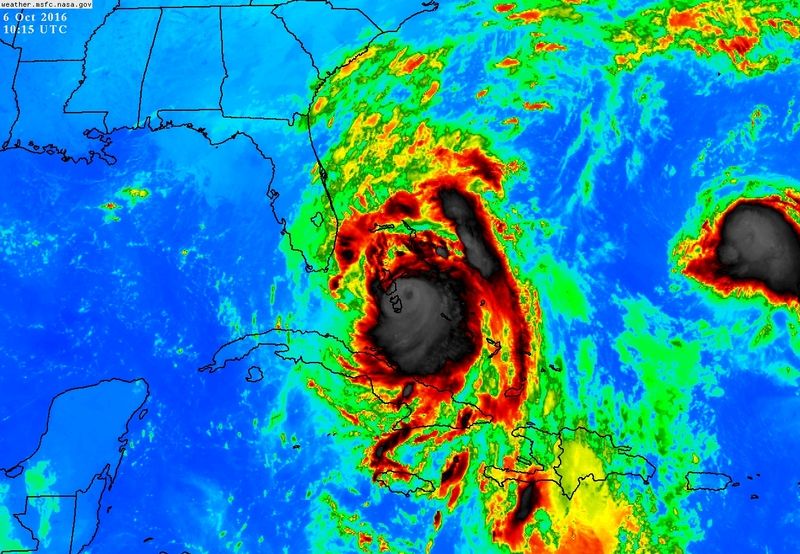
Pressure dropping. This is alreadfy dipping into the high 930s mb. This is the worst news and I really think a Cat 5 tropical cyclone nay happen in the NW Bahamas.
Last edited by northjaxpro on Thu Oct 06, 2016 5:32 am, edited 1 time in total.
1 likes
NEVER, EVER SAY NEVER in the tropics and weather in general, and most importantly, with life itself!!
________________________________________________________________________________________
Fay 2008 Beryl 2012 Debby 2012 Colin 2016 Hermine 2016 Julia 2016 Matthew 2016 Irma 2017 Dorian 2019
________________________________________________________________________________________
Fay 2008 Beryl 2012 Debby 2012 Colin 2016 Hermine 2016 Julia 2016 Matthew 2016 Irma 2017 Dorian 2019
-
MaineWeatherNut
- Tropical Storm

- Posts: 225
- Joined: Sun Sep 01, 2013 5:06 pm
Re: ATL: MATTHEW - Hurricane - Discussion
The First outer bands should be moving on shore around Miami here pretty soon. They are just off shore.
0 likes
The content of this post does NOT constitute official forecast and should not be used as such. They are the opinion of the poster and may or may not be backed by sound meteorological data. They are NOT endorsed by any professional institution or Storm2K. For official information, please refer to the local meteorological centers of respective areas.
-
drewschmaltz
- S2K Supporter
- Posts: 351
- Joined: Thu Aug 27, 2015 8:19 pm
Re: ATL: MATTHEW - Hurricane - Discussion
I was sort of hoping that Matthew would gather himself already and perform an ERC into landfall. This prolonged reorganization seems timed to have intensification into landfall. I bet we find something close to RI into landfall.
Or maybe something close to RI right now.
Or maybe something close to RI right now.
Last edited by drewschmaltz on Thu Oct 06, 2016 5:34 am, edited 1 time in total.
0 likes
I HAVE ABSOLUTELY NO IDEA WHAT I'M TALKING ABOUT. PLEASE CONSULT SOMEONE WHO DOES. START WITH THE NHC. ALL POSTS ARE FOR ENTERTAINMENT PURPOSES ONLY.

Re: ATL: MATTHEW - Hurricane - Discussion
artist wrote:Someone really needs to smack Jim Cantore upside the head. He is talking about the eye becoming cloudy which is good, it may be shear, blah, blah, blah. Someone needs to inform him it is getting stronger-not weaker, according to recon!
Yeah he did..but he also said it could strengthen over the gulf stream.
0 likes

Re: ATL: MATTHEW - Hurricane - Discussion
Matthews outflow goes out all the way into South America.
0 likes
-
jlauderdal
- S2K Supporter
- Posts: 7240
- Joined: Wed May 19, 2004 5:46 am
- Location: NE Fort Lauderdale
- Contact:
Re: ATL: MATTHEW - Hurricane - Discussion
jim cantore needs to looks at the recon reports instead of IR images....local media doing a good job, so much better than years past when it was a bunch of misinformation, no hype needed for this system so it would be tough to overhype it..we get the miami nbc station and palm beach nbc station...both have been great..i see ajog to the north right towards nassau on miami radarronjon wrote:artist wrote:Someone really needs to smack Jim Cantore upside the head. He is talking about the eye becoming cloudy which is good, it may be shear, blah, blah, blah. Someone needs to inform him it is getting stronger-not weaker, according to recon!
Yeah he did..but he also said it could strengthen over the gulf stream.
2 likes
-
Hypercane_Kyle

- Category 5

- Posts: 3465
- Joined: Sat Mar 07, 2015 7:58 pm
- Location: Cape Canaveral, FL
Re: ATL: MATTHEW - Hurricane - Discussion
I grew up in Cape Canaveral. This situation is so heartbreaking to watch unfold. Terrified that the NASA launch facilities could be irrevocably damaged by this event too.
2 likes
My posts are my own personal opinion, defer to the National Hurricane Center (NHC) and other NOAA products for decision making during hurricane season.

Re: ATL: MATTHEW - Hurricane - Discussion
ronjon wrote:jhpigott wrote:artist wrote:What about north Palm Beach county? Tia.
Ditto that question. I'm in the North Palm Beach/Juno Beach area and my point forecast calling for 65-85 sustained from the N gusting to 105. Sound reasonable? Looks like we may catch part of the western eyewall. I guess my concern would be a little jog west and we catch the northern eyewall (or God forbid the north eastern eyewall)
Not trying to scare you, but you could be ground zero for landfall of a 140 mph hurricane. Many reliable models bring the storm in near your location.
Yep, that's my concern. If the NHC track holds we'll be in the western core of a 140mph hurricane, which would likely give me high end Cat 1/ low end Cat 2 conditions similar to what we got with Jeanne and Wilma. A track little further west and we catch the N/NE part of the core and potentially a whole other ballgame. Going to be close
0 likes
-
northjaxpro
- S2K Supporter
- Posts: 8900
- Joined: Mon Sep 27, 2010 11:21 am
- Location: Jacksonville, FL
Re: ATL: MATTHEW - Hurricane - Discussion
This is just a frightening sight currently. An intensifying tropical cyclone taking advantage of nearly ideal conditons in the Bahamas. The even more frightening thought is that the cyclone has yet to move over the Gulf Stream.
:Everyone in the Bahamas and in the path of Matthew PLEASE STAY SAFE!! Everywhere along the Florida East Coast are looking at potential extreme impacts. Terrible situation unfolding .
:Everyone in the Bahamas and in the path of Matthew PLEASE STAY SAFE!! Everywhere along the Florida East Coast are looking at potential extreme impacts. Terrible situation unfolding .
Last edited by northjaxpro on Thu Oct 06, 2016 5:47 am, edited 2 times in total.
3 likes
NEVER, EVER SAY NEVER in the tropics and weather in general, and most importantly, with life itself!!
________________________________________________________________________________________
Fay 2008 Beryl 2012 Debby 2012 Colin 2016 Hermine 2016 Julia 2016 Matthew 2016 Irma 2017 Dorian 2019
________________________________________________________________________________________
Fay 2008 Beryl 2012 Debby 2012 Colin 2016 Hermine 2016 Julia 2016 Matthew 2016 Irma 2017 Dorian 2019
-
SouthDadeFish

- Professional-Met

- Posts: 2835
- Joined: Thu Sep 23, 2010 2:54 pm
- Location: Miami, FL
- Contact:


-
Hypercane_Kyle
- Category 5
- Posts: 3465
- Joined: Sat Mar 07, 2015 7:58 pm
- Location: Cape Canaveral, FL
Re: ATL: MATTHEW - Hurricane - Discussion
VDM no longer showing an open eye.
0 likes
My posts are my own personal opinion, defer to the National Hurricane Center (NHC) and other NOAA products for decision making during hurricane season.
-
KBBOCA
- S2K Supporter
- Posts: 1559
- Joined: Fri Sep 05, 2003 5:27 am
- Location: Formerly Boca Raton, often West Africa. Currently Charlotte NC
Re: ATL: MATTHEW - Hurricane - Discussion
My heart is so heavy this morning... for Haiti, Cuba and the Bahamas...
and now all on the FL / GA / SC coast.
This is truly looking like one of the "worst case scenarios" so many of us used to banter about, perhaps not really believing we'd ever see it materialize in our lifetimes. So much climatology and history is against the current forecast track, but it looks like it's going to happen. All the models and NHC seem in very earnest agreement about the rough scenario unfolding where basically the whole coastline from Broward on up to Myrtle Beach may get raked by an incredibly strong and dangerous storm.
Hate what I'm seeing about the pressure drops and the storm continuing to get its act together. Praying much for all of you directly affected by the storm or who have loved ones in its path. May you all find safe places of shelter and many friends, family and neighbors supporting each other during these difficult days.
7 likes
-
MGC

- S2K Supporter
- Posts: 5940
- Joined: Sun Mar 23, 2003 9:05 pm
- Location: Pass Christian MS, or what is left.
Re: ATL: MATTHEW - Hurricane - Discussion
Oh man, I didn't expect Matthew to intensify this quickly since I went to bed shortly after the 11pm advisory. That pressure plunge is scary. This hurricane is most likely going to be a Cat-4 as forecast by NHC. Looks like Matthew is going to shoot the gap between Andros Island and New Providence Island putting Nassau in the RFQ eyewall. Really think it would be a good idea if you live close to the coast in the hurricane warned area to flee today. The is going to be a catastrophe of epic proportions....MGC
0 likes
-
Hypercane_Kyle
- Category 5
- Posts: 3465
- Joined: Sat Mar 07, 2015 7:58 pm
- Location: Cape Canaveral, FL
Re: ATL: MATTHEW - Hurricane - Discussion
EWRC? Radar is showing an intense band developing around the eyewall.
http://radar.weather.gov/radar.php?rid=AMX&product=N0Z&overlay=11101111&loop=yes
http://radar.weather.gov/radar.php?rid=AMX&product=N0Z&overlay=11101111&loop=yes
0 likes
My posts are my own personal opinion, defer to the National Hurricane Center (NHC) and other NOAA products for decision making during hurricane season.
-
MaineWeatherNut
- Tropical Storm
- Posts: 225
- Joined: Sun Sep 01, 2013 5:06 pm
Re: ATL: MATTHEW - Hurricane - Discussion
Hypercane_Kyle wrote:EWRC? Radar is showing an intense band developing around the eyewall.
http://radar.weather.gov/radar.php?rid=AMX&product=N0Z&overlay=11101111&loop=yes
doubt it... Per the last VDM there is still a healthy 16 mile wide eye. still plenty of room for it to contract. Also recon isn't showing any sort of secondary wind maximum at the moment.
0 likes
The content of this post does NOT constitute official forecast and should not be used as such. They are the opinion of the poster and may or may not be backed by sound meteorological data. They are NOT endorsed by any professional institution or Storm2K. For official information, please refer to the local meteorological centers of respective areas.
-
HurricaneEric
- Tropical Storm
- Posts: 146
- Age: 31
- Joined: Mon Sep 07, 2015 11:06 am
- Location: Miami, FL
Re: ATL: MATTHEW - Hurricane - Discussion
Man... I know Miami is gonna dodge a bit of a bullet here but seeing a monster major hurricane this close to the coast still makes me feel really uneasy.
Hoping and praying for those who will have to deal with the worst of this storm.
Hoping and praying for those who will have to deal with the worst of this storm.
1 likes
Irene '99, Katrina '05, Wilma '05, Irma '17 (storms I remember my area getting hurricane force winds/gusts).
The posts in this forum are NOT official forecast and shouldn't be used as such. They are just the opinion of the poster and may or may not be backed by sound meteorological data. For official information, please refer to the experts.
The posts in this forum are NOT official forecast and shouldn't be used as such. They are just the opinion of the poster and may or may not be backed by sound meteorological data. For official information, please refer to the experts.
-
brunota2003

- S2K Supporter
- Posts: 9476
- Age: 35
- Joined: Sat Jul 30, 2005 9:56 pm
- Location: Stanton, KY...formerly Havelock, NC
- Contact:
Re: ATL: MATTHEW - Hurricane - Discussion
brunota2003 wrote:Here is something we did before Isabel hit NC in 2003: Take a video of EVERYTHING you can for insurance purposes. On high dollar equipment (TV, Computers, etc), write down the make, model, S/N, and if you know it, the value (basically making a high value cheat sheet). We had outbuildings that were full of tools. We took video showing every tool in every tool chest, and wrote down information we thought might be pertinent in the event we needed to file an insurance claim. Thankfully for us, Isabel weakened and we didn't need the video...but for those worried about possibly losing things, it'll give you something to do other than just sitting around worrying.
Of course if you evacuate, be sure you take the list and video with you. It doesn't do you any good if you lose it, too.
Just reposting this for all those waking up this morning...given I posted it around 2 am this morning, which means it is long buried by now!
2 likes
Just a small town southern boy helping other humans.
Re: ATL: MATTHEW - Hurricane - Discussion
NDG wrote:Matthew and his little sister Nicole racking up the ACE over the Atlantic.
That is so weird. Can someone explain to me how Nicole's presence is impacting/influencing Matthew?
TIA
1 likes
Cleo - 1964, Betsy - 1965, David - 1979, Andrew - 1992, Charlie (Francis, Ivan, Jeanne) - 2004, Irma - 2017, Ian - 2022, Milton - 2024
Who is online
Users browsing this forum: No registered users and 15 guests