Texas Winter 2016-2017

Winter Weather Discussion

Moderator: S2k Moderators

Forum rules

The posts in this forum are NOT official forecast and should not be used as such. They are just the opinion of the poster and may or may not be backed by sound meteorological data. They are NOT endorsed by any professional institution or STORM2K.

Help Support Storm2K
Message
Author
User avatar
Portastorm
Storm2k Moderator
Storm2k Moderator
Posts: 9914
Age: 63
Joined: Fri Jul 11, 2003 9:16 am
Location: Round Rock, TX
Contact:

Re: Texas Winter 2016-2017

#2561 Postby Portastorm » Sat Dec 31, 2016 9:42 am

srainhoutx wrote:Will need to monitor for Severe thunderstorms with all modes of severe weather possible across Texas New Years Day extending East into Louisiana on Monday.


Indeed, sir. That is the most real and immediate concern. Severe wx for much of Texas looking more and more likely, unfortunately.

Imageimgurl
0 likes   
Any forecasts under my name are to be taken with a grain of salt. Get your best forecasts from the National Weather Service and National Hurricane Center.

User avatar
gboudx
S2K Supporter
S2K Supporter
Posts: 4080
Joined: Thu Sep 04, 2003 1:39 pm
Location: Rockwall, Tx but from Harvey, La

Re: Texas Winter 2016-2017

#2562 Postby gboudx » Sat Dec 31, 2016 9:48 am

wxman57 wrote:As you can all see, I'm having some luck adjusting the southern U.S. thermostat upwards for next week. Perhaps in another day or two I'll be able to get rid of that nasty Arctic air completely.


If there's anyway I can help let me know. Since I'm further upstream from you, I can try and halt it at the Red River. Durant could be cloudy and in the 30s, while DFW is basking in sunshine and the 70s.
0 likes   

User avatar
bubba hotep
S2K Supporter
S2K Supporter
Posts: 5837
Joined: Wed Dec 28, 2016 1:00 am
Location: Collin County Texas

Re: Texas Winter 2016-2017

#2563 Postby bubba hotep » Sat Dec 31, 2016 10:03 am

After flipping through some analogs, the current +PDO seems to be the wrench in things, if you are looking for another big cold snap with this forecasted -EPO. Dec '83 was during a +PDO but most others were during -PDO periods - '49, '51, '62, '64, '73, '75, '13. The next step would be to see if there is any trend of -EPO events not delivering a cold dump during a +PDO but time to start pregaming for LSU vs Louisville.

Over the last few days there was a pretty big warm signal in the ensemble spread with the operational runs on the colder edge of the spread, so the potential was always there for the ops to trend warmer. We don't need bitter cold to get snow in DFW, just a better timed ejection of the energy out of the West. So models, stop cutting things off and dumping snow on Northern Cali.
0 likes   
Winter time post are almost exclusively focused on the DFW area.

User avatar
bubba hotep
S2K Supporter
S2K Supporter
Posts: 5837
Joined: Wed Dec 28, 2016 1:00 am
Location: Collin County Texas

Re: Texas Winter 2016-2017

#2564 Postby bubba hotep » Sat Dec 31, 2016 10:06 am

Portastorm wrote:
srainhoutx wrote:Will need to monitor for Severe thunderstorms with all modes of severe weather possible across Texas New Years Day extending East into Louisiana on Monday.


Indeed, sir. That is the most real and immediate concern. Severe wx for much of Texas looking more and more likely, unfortunately.

https://s19.postimg.org/vbq3u9cmb/image5.pngimgurl


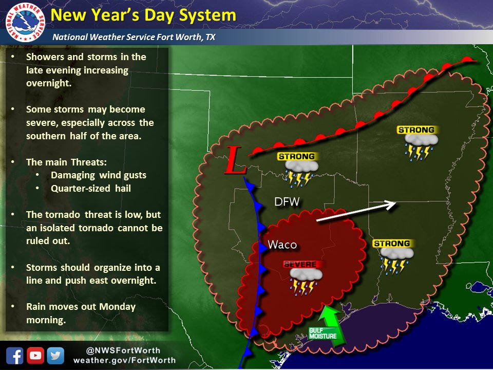
This has certainly been flying under the radar and no one wants any holiday trouble after Dec 26 of last year. Here is the latest thinking from FWD:

Image
0 likes   
Winter time post are almost exclusively focused on the DFW area.

User avatar
Portastorm
Storm2k Moderator
Storm2k Moderator
Posts: 9914
Age: 63
Joined: Fri Jul 11, 2003 9:16 am
Location: Round Rock, TX
Contact:

Re: Texas Winter 2016-2017

#2565 Postby Portastorm » Sat Dec 31, 2016 10:21 am

Well, this excerpt from the 3-7 day forecast discussion is from the experts themselves at the NWS Weather Prediction Center. Pretty much lays it all out there:

BY NEXT THURS/FRI/SAT... EVERYTHING REVOLVES AROUND THE
PROGRESSION OF UPPER DYNAMICS FROM THE WEST MOVING DOWNSTREAM AND
WHETHER WE ARE DEALING WITH MULTI-STREAMS OR A PHASING SYSTEM
WITHIN STEADY SWRLY FLOW ALOFT. THIS IS RATHER IMPORTANT... AS THE
ARCTIC COLD FRONT GENERALLY STALLS NEAR THE SOUTHEAST COAST AND
ACROSS NRN FL INTO THE GULF OF MEXICO AND MOISTURE COULD BEGIN TO
OVERRUN INTO THE THEN ESTABLISHED COLD SECTOR OVER THE EAST/SOUTH.
THE MORE AMPLIFIED SOLUTIONS MEANS MOISTURE EASILY REACHING THE
COLD SECTOR FOR A POSSIBLE EXPANSIVE AREA OF FROZEN PRECIP...
WHILE THE SHEARED-OUT SOLUTIONS MEANS A SUPPRESSED SOLUTION OF
MAINLY RAIN AND NOT OF MUCH MOISTURE SPREADING NORTHWARD. THERE IS
JUST TOO MUCH SPREAD AT THIS POINT TO PUT STOCK IN ANY SOLUTION.
THIS LATE WEEK SCENARIO WILL EASILY EVOLVE AND DEFINITELY BEARS
WATCHING.
0 likes   
Any forecasts under my name are to be taken with a grain of salt. Get your best forecasts from the National Weather Service and National Hurricane Center.

User avatar
ThunderSleetDreams
S2K Supporter
S2K Supporter
Posts: 1477
Age: 43
Joined: Tue Dec 20, 2011 4:42 pm
Location: S of Weimar, TX

Re: Texas Winter 2016-2017

#2566 Postby ThunderSleetDreams » Sat Dec 31, 2016 10:22 am

bubba hotep wrote:After flipping through some analogs, the current +PDO seems to be the wrench in things, if you are looking for another big cold snap with this forecasted -EPO. Dec '83 was during a +PDO but most others were during -PDO periods - '49, '51, '62, '64, '73, '75, '13. The next step would be to see if there is any trend of -EPO events not delivering a cold dump during a +PDO but time to start pregaming for LSU vs Louisville.

Over the last few days there was a pretty big warm signal in the ensemble spread with the operational runs on the colder edge of the spread, so the potential was always there for the ops to trend warmer. We don't need bitter cold to get snow in DFW, just a better timed ejection of the energy out of the West. So models, stop cutting things off and dumping snow on Northern Cali.


THte thing is, in Neutral cold or weak Nina Years a positive PDO creates strong SE ridges which is not a feature in the upcoming days. The models are either missing something or we are entering a very anomalous situation.
0 likes   
#NeverSummer

I hibernate when it gets above 75 degrees!

User avatar
TeamPlayersBlue
Category 5
Category 5
Posts: 3446
Joined: Tue Feb 02, 2010 1:44 am
Location: Denver/Applewood, CO

Re: Texas Winter 2016-2017

#2567 Postby TeamPlayersBlue » Sat Dec 31, 2016 10:58 am

That high building off the coast of Mexico is ruining our chances of snow. That thing is the WORST.
0 likes   
Personal Forecast Disclaimer:
The posts in this forum are NOT official forecast and should not be used as such. They are just the opinion of the poster and may or may not be backed by sound meteorological data. They are NOT endorsed by any professional institution or storm2k.org. For official information, please refer to the NHC and NWS products.

User avatar
hriverajr
Professional-Met
Professional-Met
Posts: 786
Joined: Tue Jul 19, 2005 12:16 am

Re: Texas Winter 2016-2017

#2568 Postby hriverajr » Sat Dec 31, 2016 11:38 am

I will say this. Thats a serious ridge building up into Alaska, and it appears it will continue to amplify. My only issue is once again the lack of really strong surface pressure. High pressure is actually located just off the southern Alaska coast at about 1041. Short range models do not indicate it strengthening too much at this point, and there have been no major pressure rises. I have not looked at medium and long range models as they seem to be all over the place.

Not even thinking about precip chances, unless we get stronger high pressure we won't have much of a delivery mechanism, so it could get cold like a couple of weeks ago, but it would not have much staying power imo. I'll be watching how things go in real time. Sometimes.. you don't need the models to get a decent idea on things 3-5 days down the road. :)
0 likes   
Anything I post is my personal opinion and should not used for any type of planning or lifesaving reasons. Please refer to National Weather Service forecasts.

User avatar
starsfan65
Category 2
Category 2
Posts: 704
Age: 47
Joined: Thu Dec 17, 2015 1:18 pm
Location: Garland,Tx

Re: Texas Winter 2016-2017

#2569 Postby starsfan65 » Sat Dec 31, 2016 11:48 am

hriverajr wrote:I will say this. Thats a serious ridge building up into Alaska, and it appears it will continue to amplify. My only issue is once again the lack of really strong surface pressure. High pressure is actually located just off the southern Alaska coast at about 1041. Short range models do not indicate it strengthening too much at this point, and there have been no major pressure rises. I have not looked at medium and long range models as they seem to be all over the place.

Not even thinking about precip chances, unless we get stronger high pressure we won't have much of a delivery mechanism, so it could get cold like a couple of weeks ago, but it would not have much staying power imo. I'll be watching how things go in real time. Sometimes.. you don't need the models to get a decent idea on things 3-5 days down the road. :)

The Storm system is still 4000 miles away.
0 likes   

User avatar
Ntxw
Storm2k Moderator
Storm2k Moderator
Posts: 22792
Joined: Wed Oct 21, 2009 6:34 pm
Location: DFW, Texas

Re: Texas Winter 2016-2017

#2570 Postby Ntxw » Sat Dec 31, 2016 11:59 am

hriverajr wrote:I will say this. Thats a serious ridge building up into Alaska, and it appears it will continue to amplify. My only issue is once again the lack of really strong surface pressure. High pressure is actually located just off the southern Alaska coast at about 1041. Short range models do not indicate it strengthening too much at this point, and there have been no major pressure rises. I have not looked at medium and long range models as they seem to be all over the place.

Not even thinking about precip chances, unless we get stronger high pressure we won't have much of a delivery mechanism, so it could get cold like a couple of weeks ago, but it would not have much staying power imo. I'll be watching how things go in real time. Sometimes.. you don't need the models to get a decent idea on things 3-5 days down the road. :)


It's been a really strange winter season regarding surface ridges. The only OP guidance that really drives the surface pressures to town is the JMA. It's really weird you have such strong 5h Alaskan/GOA ridging and can't muster a 1050Hpa surface ridge. But there is cold waters in the GOA itself though, however which is what drove the huge +PDO uptick in October and November.

Which btw the Nina (which may not get the qualification due to lack of 5 consecutive trimonthlies) looks about toast, it's little more than a band barely cool anomalies. We may be heading into warm neutral pretty soon.
1 likes   
The above post and any post by Ntxw is NOT an official forecast and should not be used as such. It is just the opinion of the poster and may or may not be backed by sound meteorological data. It is NOT endorsed by any professional institution including Storm2k. For official information, please refer to NWS products.

  Help support Storm2K!
Help Support Storm2K

User avatar
Portastorm
Storm2k Moderator
Storm2k Moderator
Posts: 9914
Age: 63
Joined: Fri Jul 11, 2003 9:16 am
Location: Round Rock, TX
Contact:

Re: Texas Winter 2016-2017

#2571 Postby Portastorm » Sat Dec 31, 2016 12:04 pm

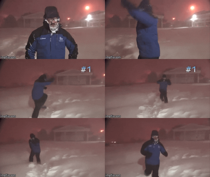
I'm not too concerned yet, but I have to admit that if both the GFS and Euro are showing the milder/drier solutions by their Sunday night overnight 0z runs ... then I think it'll be time to "bag it" and move on. It is wild to think about how much change we have seen in the operational runs in the last 48 hours. These models ... their trolling us!

Imageupload gambar
1 likes   
Any forecasts under my name are to be taken with a grain of salt. Get your best forecasts from the National Weather Service and National Hurricane Center.

ronyan
S2K Supporter
S2K Supporter
Posts: 791
Age: 39
Joined: Tue Sep 09, 2008 5:46 pm
Location: Lake Jackson, TX

Re: Texas Winter 2016-2017

#2572 Postby ronyan » Sat Dec 31, 2016 12:12 pm

Yeah the models could be losing the cold in the medium range. The 12 GFS does have my location below 50F for 78 hours so it is cold still.
0 likes   

User avatar
lrak
S2K Supporter
S2K Supporter
Posts: 1770
Age: 58
Joined: Thu Jun 21, 2007 2:48 pm
Location: Corpus Christi, TX

Re: Texas Winter 2016-2017

#2573 Postby lrak » Sat Dec 31, 2016 12:57 pm

Portastorm wrote:I'm not too concerned yet, but I have to admit that if both the GFS and Euro are showing the milder/drier solutions by their Sunday night overnight 0z runs ... then I think it'll be time to "bag it" and move on. It is wild to think about how much change we have seen in the operational runs in the last 48 hours. These models ... their trolling us!

Imageupload gambar


that looks like wxman57 hacking the models :D

i have a feeling it's going to get cold in my area, 50 for a high is COLD if you've lived in the mild to extreme heat for as long as I have :cold:
0 likes   
AKA karl

Also
Personal Forecast Disclaimer:
My posts on this forum are NOT official forecast and should not be used as such. My posts are my basic observations and are definitely not backed by any "well some" meteorological knowledge. For official information, please refer to the NHC and NWS products.

Brent
S2K Supporter
S2K Supporter
Posts: 38106
Age: 37
Joined: Sun May 16, 2004 10:30 pm
Location: Tulsa Oklahoma
Contact:

Re: Texas Winter 2016-2017

#2574 Postby Brent » Sat Dec 31, 2016 1:24 pm

Euro looks similar to the 0z so far... not much to write about through Thursday morning

Temps in the low/mid 30s Thursday afternoon but dry dry dry.
0 likes   
#neversummer

User avatar
Ntxw
Storm2k Moderator
Storm2k Moderator
Posts: 22792
Joined: Wed Oct 21, 2009 6:34 pm
Location: DFW, Texas

Re: Texas Winter 2016-2017

#2575 Postby Ntxw » Sat Dec 31, 2016 1:33 pm

Euro has light snow/flurries with the ejecting shortwave Friday. GFS had small bouts in Oklahoma and Arkansas
0 likes   
The above post and any post by Ntxw is NOT an official forecast and should not be used as such. It is just the opinion of the poster and may or may not be backed by sound meteorological data. It is NOT endorsed by any professional institution including Storm2k. For official information, please refer to NWS products.


  Help support Storm2K!

Help Support Storm2K


User avatar
srainhoutx
S2K Supporter
S2K Supporter
Posts: 6919
Age: 67
Joined: Sun Jan 14, 2007 11:34 am
Location: Haywood County, NC
Contact:

Re: Texas Winter 2016-2017

#2576 Postby srainhoutx » Sat Dec 31, 2016 1:39 pm

Differences via the GEFS and the ECMWF solutions over 00Z runs. Expect continued volatility until about Tuesday/Wednesday.
0 likes   
Carla/Alicia/Jerry(In The Eye)/Michelle/Charley/Ivan/Dennis/Katrina/Rita/Wilma/Ike/Harvey

Member: National Weather Association
Wx Infinity Forums
http://wxinfinity.com/index.php

Facebook.com/WeatherInfinity
Twitter @WeatherInfinity

User avatar
wxman57
Moderator-Pro Met
Moderator-Pro Met
Posts: 22991
Age: 67
Joined: Sat Jun 21, 2003 8:06 pm
Location: Houston, TX (southwest)

Re: Texas Winter 2016-2017

#2577 Postby wxman57 » Sat Dec 31, 2016 1:53 pm

If I can be serious, for a moment, I'm looking at the current and projected 500mb flow across Alaska & Canada (GFS). Yeah, that's a pretty big ridge building over Alaska, but look at the flow pattern, look where the air in western Canada is coming from - the Pacific. In past severe cold events across Texas, there wasn't a big ridge over Alaska, it was farther east and tapping into Siberian air across the Pole. During the very cold winter of '76-'77, it was unusually warm over Alaska. I remember hearing a story of U.S. troops on winter survival training in Alaska suffering from heat exhaustion in their Arctic gear.

As I always say, look at the source region of the cold air. It's really not cold in NW Canada or Alaska. The colder air is well to the east over north-central Canada, and even then it's not nearly as cold as with the Arctic outbreak a few weeks ago. True, we don't need extremely cold Arctic air to get frozen precip across Texas, but given the recent warmth across the Central Plains and the northern extent of the snow cover, it's going to be hard to get enough deep cold air over Texas for snow over the next week or so. It's possible that a cross-Polar flow will develop in the coming weeks, allowing some extremely cold Siberian air to head south into the U.S., but I don't see that happening over the next 7-10 days.

That said, the models are going to have a very tough time with the current and predicted weather pattern. Don't get your hopes up for any freezing/frozen precip until it appears in the 2-3 day model guidance, there is agreement in all global models, AND model runs are consistently showing such precip each run. For now, I expect we'll see some colder air this coming week and next, but it may not even be cold enough to produce a freeze down to Houston. I'm not saying we won't see a freeze, just that there is no guarantee of one. As for frozen precip across SE TX, I'm not concerned/excited about it for the next 7-10 days.

Image

Image
1 likes   

gpsnowman
S2K Supporter
S2K Supporter
Posts: 3191
Joined: Fri Jan 07, 2011 10:35 am
Location: Grand Prairie Tx

Re: Texas Winter 2016-2017

#2578 Postby gpsnowman » Sat Dec 31, 2016 1:58 pm

:uarrow: Good post. For me, I don't care if we see teens again or not. Just a couple days hovering around freezing or just below with some precip is a-ok. And I am looking forward to the rain on New Years Day. Nothing severe of course but it would be nice to hear some thunder.
0 likes   

User avatar
bubba hotep
S2K Supporter
S2K Supporter
Posts: 5837
Joined: Wed Dec 28, 2016 1:00 am
Location: Collin County Texas

Re: Texas Winter 2016-2017

#2579 Postby bubba hotep » Sat Dec 31, 2016 2:10 pm

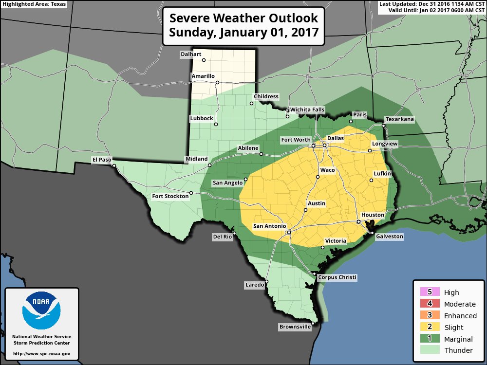
Day 2 northward expansion to include a good portion of the DFW area. The 12z Euro looks pretty juicy for tomorrow night.

Image
0 likes   
Winter time post are almost exclusively focused on the DFW area.

User avatar
JDawg512
Category 5
Category 5
Posts: 1078
Age: 45
Joined: Mon Aug 26, 2013 8:56 pm
Location: Austin
Contact:

Re: Texas Winter 2016-2017

#2580 Postby JDawg512 » Sat Dec 31, 2016 3:21 pm

bubba hotep wrote:Day 2 northward expansion to include a good portion of the DFW area. The 12z Euro looks pretty juicy for tomorrow night.

Image


Yes I the Rain Miser wanted to ring in the New year with a bang, but don't worry, these storms shouldn't get out of hand. What better way to enjoy the 1st of the year with natural fireworks.. :ggreen:
0 likes   
Resident Rain Miser

I am a weather hobbyist living 3.5 miles south of Downtown Austin and in no way or fashion should anything I say concerning forecasts be taken seriously. Please check your local NWS for accurate weather forecasting and conditions.


Return to “Winter Weather”

Who is online

Users browsing this forum: No registered users and 37 guests