ATL: IRMA - Post-Tropical - Discussion
Moderator: S2k Moderators
-
tropicwatch

- Category 5

- Posts: 3426
- Age: 62
- Joined: Sat Jun 02, 2007 10:01 am
- Location: The Villages, Florida
- Contact:
Re: ATL: IRMA - Recon Discussion Thread
Whose flying the plane? Stevie Wonder! Just kidding, probably having some instrumentation issues would be my guess. 
0 likes
Tropicwatch
Agnes 72', Eloise 75, Elena 85', Kate 85', Charley 86', Florence 88', Beryl 94', Dean 95', Erin 95', Opal 95', Earl 98', Georges 98', Ivan 2004', Arlene 2005', Dennis 2005', Ida 2009' Debby 2012' Irma 2017' Michael 2018'
Agnes 72', Eloise 75, Elena 85', Kate 85', Charley 86', Florence 88', Beryl 94', Dean 95', Erin 95', Opal 95', Earl 98', Georges 98', Ivan 2004', Arlene 2005', Dennis 2005', Ida 2009' Debby 2012' Irma 2017' Michael 2018'
-
Blown Away

- S2K Supporter

- Posts: 10253
- Joined: Wed May 26, 2004 6:17 am
Re: ATL: IRMA - Hurricane - Discussion


Irma looks to pass a couple degrees N of the forecast point, could average out, but steady close to due W for past few hours...
0 likes
Hurricane Eye Experience: David 79, Irene 99, Frances 04, Jeanne 04, Wilma 05… Hurricane Brush Experience: Andrew 92, Erin 95, Floyd 99, Matthew 16, Irma 17, Ian 22, Nicole 22…
-
flamingosun

- S2K Supporter
- Posts: 197
- Joined: Wed Sep 15, 2004 4:51 am
- Location: Merritt Island, FL
Re: ATL: IRMA - Hurricane - Discussion
Puerto Rico has declared a state of emergency and activated the National Guard.
4 likes
-
galaxy401

- Category 5
- Posts: 2446
- Age: 30
- Joined: Sat Aug 25, 2012 9:04 pm
- Location: Casa Grande, Arizona
Re: ATL: IRMA - Hurricane - Discussion
Get ready everyone, this is where things are going to get very stressful for the next week. Category 4 now. Going to be a very long week. Stay prepared everyone in Irma's potential path...
2 likes
Got my eyes on moving right into Hurricane Alley: Florida.

Re: ATL: IRMA - Hurricane - Discussion
Why would the storm do that in such a short period of time. Irma is addicted to EWRC'S. 
Aric Dunn wrote:Evil Jeremy wrote:RL3AO wrote:Large new eyewall showing up on satellite now. Intensification likely to continue.
https://i.imgur.com/iD99pC5.gif
The dry air intrusion is over. She has crossed the mid-Atlantic, now entering warmer waters. Nothing holding her back moving forward, except for further EWRCs. Would not surprise me if we're looking at RI this evening.
luckily for the islands.. IRMA will likely be going through another ERC as it passes thorugh the islands.
0 likes
-
galaxy401
- Category 5
- Posts: 2446
- Age: 30
- Joined: Sat Aug 25, 2012 9:04 pm
- Location: Casa Grande, Arizona
Re: ATL: IRMA - Hurricane - Discussion
Slight north shift in the new forecast cone.
0 likes
Got my eyes on moving right into Hurricane Alley: Florida.
Re: ATL: IRMA - Hurricane - Discussion
New 5 PM track has Irma off he coast off Northern Cuba...just north of the 11am track...also South Florida now in the 5 day cone
0 likes
-
floridasun78
- Category 5
- Posts: 3755
- Joined: Sun May 17, 2009 10:16 pm
- Location: miami fl
Re: ATL: IRMA - Hurricane - Discussion
miami weather man start get very worry their worry too people are thinking this not coming here not getting kit ready miami perople have bad habit getting ready last few days what weather man other channel saying????? my was from wfor met cheif
0 likes
-
SeaBrz_FL

- S2K Supporter
- Posts: 472
- Age: 70
- Joined: Thu Aug 12, 2004 10:47 am
- Location: Cape Canaveral, FL
Re: ATL: IRMA - Hurricane - Discussion
marciacubed wrote:StormingB81 wrote:I live in brevard county about 7 miles from the coast and I see people already boarding up....
Wpec 12 Met said it is too early to put up shutters.
Although a lot of work, boarding up practice or a trial run never hurts. Usually you will find something to improve on next time.
1 likes
Donna/WPB 1960 - terrorized for life  . Fourth of six generations living on the FL East Coast since the 50's.
-
bob rulz
- Category 5
- Posts: 1711
- Age: 36
- Joined: Sat Jan 28, 2006 7:30 pm
- Location: Salt Lake City, Utah
Re: ATL: IRMA - Hurricane - Discussion
NHC has also officially acknowledged westward motion @ 265 degrees as well. More than likely any additional southwest movement will be very slight.
0 likes
-
AdamFirst

- S2K Supporter
- Posts: 2490
- Age: 36
- Joined: Thu Aug 14, 2008 10:54 am
- Location: Port Saint Lucie, FL
Re: ATL: IRMA - Hurricane - Discussion
5 PM Discussion...maintains Category 4 throughout forecast period
The hurricane will be moving through an environment of low vertical
wind shear, a moist mid-level atmosphere, and increasing upper-ocean
heat content. These conditions favor intensification and the
intensity guidance continues to call for some additional
strengthening during the next couple of days. However, there are
likely to be eyewall cycles that are difficult to predict, which
could result in some fluctuations in intensity. Barring land
interaction with the islands of the Greater Antilles, Irma is
forecast to remain a powerful hurricane throughout the 5-day
forecast period.
Irma has been moving a little south of due west today, and the
longer-term motion estimate is 265/11 kt. The hurricane will
reach the southwestern portion of a strong mid-level ridge that is
centered over the central Atlantic later today or tonight. This
should result in a westward, then west-northwestward turn over the
next 24 to 36 hours. This motion is expected to bring the hurricane
near or over the northern Leeward Islands on Tuesday night or early
Wednesday. A large mid-latitude trough that is predicted to deepen
over the eastern U.S. during the next few days is forecast to lift
northeastward late in the week, which is expected to cause the
subtropical ridge over the western Atlantic to build westward.
As a result, Irma is predicted to remain on a general
west-northwestward heading on days 3 through 5. The dynamical
model guidance is in excellent agreement through 72 hours, with
some increase in spread late in the period, however the typically
more reliable ECMWF and GFS are in very good agreement through day
5, and the new NHC track forecast lies very close to those models.
Six hourly upper-air soundings began at 1800 UTC today over the
central United States to better sample the upstream mid-latitude
trough. In addition, the NOAA G-IV aircraft is currently sampling
the environment around Irma, and these data will be included in
tonight's 0000 UTC model runs.
Users are reminded to not focus on the exact forecast track since
strong winds and heavy rainfall extend well away from the center.
In addition, average NHC track errors are about 175 and 225 statute
miles at days 4 and 5, respectively.
KEY MESSAGES:
1. Irma is expected to affect the northeastern Leeward Islands a
dangerous major hurricane, accompanied by life-threatening wind,
storm surge, and rainfall impacts. Hurricane warnings are in effect
for portions of the Leeward Islands. Preparations should be rushed
to completion, as tropical-storm force winds are expected to first
arrive in the hurricane warning area by late Tuesday.
2. Irma could directly affect the British and U.S. Virgin Islands
and Puerto Rico as a dangerous major hurricane later this week.
Hurricane watches have been issued for these areas, and tropical-
storm-force winds could arrive in these areas by early Wednesday.
3. Irma could directly affect Hispaniola, the Turks and Caicos, the
Bahamas, and Cuba as a dangerous major hurricane later this week.
Residents in these areas should monitor the progress of Irma and
listen to advice given by officials.
4. There is an increasing chance of seeing some impacts from Irma in
the Florida Peninsula and the Florida Keys later this week and this
weekend. Otherwise, it is still too early to determine what direct
impacts Irma might have on the continental United States. However,
everyone in hurricane-prone areas should ensure that they have their
hurricane plan in place.
FORECAST POSITIONS AND MAX WINDS
INIT 04/2100Z 16.7N 54.4W 115 KT 130 MPH
12H 05/0600Z 16.6N 56.2W 125 KT 145 MPH
24H 05/1800Z 17.0N 58.7W 130 KT 150 MPH
36H 06/0600Z 17.8N 61.3W 130 KT 150 MPH
48H 06/1800Z 18.7N 64.1W 125 KT 145 MPH
72H 07/1800Z 20.4N 69.7W 120 KT 140 MPH
96H 08/1800Z 21.6N 74.8W 115 KT 130 MPH
120H 09/1800Z 23.0N 79.0W 115 KT 130 MPH
1 likes
Dolphins Marlins Canes Golden Panthers HEAT
Andrew 1992 - Irene 1999 - Frances 2004 - Jeanne 2004 - Wilma 2005 - Fay 2008 - Isaac 2012 - Matthew 2016 - Irma 2017 - Dorian 2019 - Ian 2022 - Nicole 2022 - Milton 2024
Andrew 1992 - Irene 1999 - Frances 2004 - Jeanne 2004 - Wilma 2005 - Fay 2008 - Isaac 2012 - Matthew 2016 - Irma 2017 - Dorian 2019 - Ian 2022 - Nicole 2022 - Milton 2024
-
Blown Away
- S2K Supporter
- Posts: 10253
- Joined: Wed May 26, 2004 6:17 am
Re: ATL: IRMA - Hurricane - Discussion
Lowest Latitude Predicted By Past Few NHC Forecasts:
11pm: ??? (Monday Night)
5pm: 16.6
11am:16.5
5am: 16.6
11pm: 16.5 (Sunday Night) NHC has Irma dropping father down...
5pm: 16.8
11am: 16.4
5am: 16.5
11pm: 16.5 (Saturday Night)
5pm: 16.8
11am: 17.1
5am: 17.0
11pm: 16.8 (Friday Night)
*Let's see if these subtle 6,12,18 mile adjustments N due to Irma not dropping to the predicted latitude makes a difference?
0 likes
Hurricane Eye Experience: David 79, Irene 99, Frances 04, Jeanne 04, Wilma 05… Hurricane Brush Experience: Andrew 92, Erin 95, Floyd 99, Matthew 16, Irma 17, Ian 22, Nicole 22…
-
Meteorcane

- Category 2

- Posts: 559
- Joined: Thu Jul 21, 2011 6:49 am
- Location: North Platte Nebraska
Re: ATL: IRMA - Hurricane - Discussion
GCANE wrote:
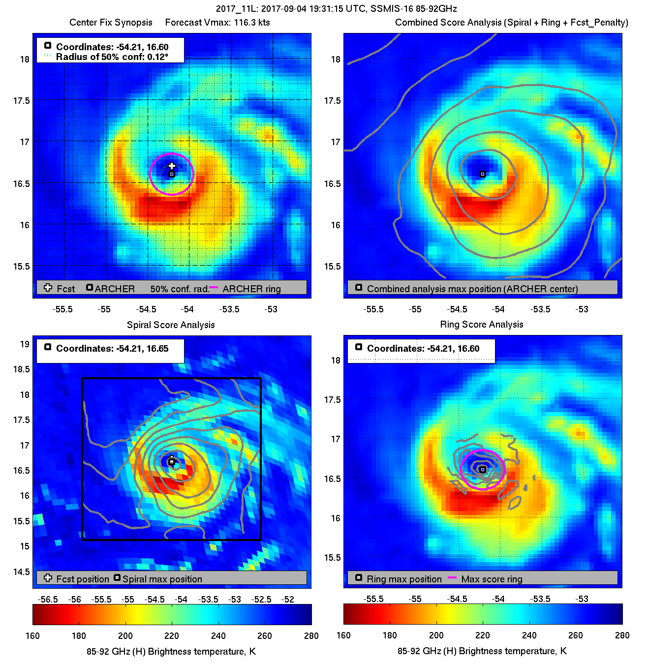
Could you explain these plots for me please? I am quite familiar with Microwave brightness temperatures as one of my projects in grad.school was improving Tb-Rain rate algorithms associated with the TRMM satellite. Are these analogs to the Dvorak Technique (i.e. an estimator of TC intensity), but using MW instead of IR? Or are these just estimators of the exact center location using the MW imagery?
Last edited by Meteorcane on Mon Sep 04, 2017 3:58 pm, edited 1 time in total.
1 likes
-
meriland29

- Category 2
- Posts: 770
- Joined: Thu Aug 03, 2017 11:05 am
Re: ATL: IRMA - Hurricane - Discussion
She 'looks' like she is getting larger in diameter..

Last edited by meriland29 on Mon Sep 04, 2017 3:58 pm, edited 1 time in total.
2 likes
-
jlauderdal
- S2K Supporter
- Posts: 7240
- Joined: Wed May 19, 2004 5:46 am
- Location: NE Fort Lauderdale
- Contact:
Re: ATL: IRMA - Hurricane - Discussion
yes that is craig setzer, he is very good..setzer and john Morales on channel 6 are really the go to weather people...when they say to put shutters up then you do it..5 cases of water sitting my garage, generator ready just need 50 gallons of gas....i will be prepared for 5 days no power, no help,nothingfloridasun78 wrote:miami weather man start get very worry their worry too people are thinking this not coming here not getting kit ready miami perople have bad habit getting ready last few days what weather man other channel saying????? my was from wfor met cheif
4 likes

Re: ATL: IRMA - Hurricane - Discussion
I hate to think of what could happen if this started rapidly intensifying. I have been to the Virgin Islands, and many of the structures are not capable of surviving Cat 4-5 winds. I'm praying for the islands now.
4 likes
Igor 2010, Sandy 2012, Fay 2014, Gonzalo 2014, Joaquin 2015, Nicole 2016, Humberto 2019, Imelda 2025
I am only a tropical weather enthusiast. My predictions are not official and may or may not be backed by sound meteorological data. For official information, please refer to the NHC and NWS products.
I am only a tropical weather enthusiast. My predictions are not official and may or may not be backed by sound meteorological data. For official information, please refer to the NHC and NWS products.

Re: ATL: IRMA - Hurricane - Discussion
Meteorcane wrote:GCANE wrote:
Could you explain these plots for me please? I am quite familiar with Microwave brightness temperatures as one of my projects in grad.school was improving Tb-Rain rate algorithms associated with the TRMM satellite. Are these analogs to the Dvorak Technique (i.e. an estimator of TC intensity), but using MW instead of IR? Or are these just estimators of the exact center location using the MW imagery?
They are position estimators. Part of a suite that uses VIS and IR as well.
0 likes
-
johngaltfla

- Category 5
- Posts: 2073
- Joined: Sun Jul 10, 2005 9:17 pm
- Location: Sarasota County, FL
- Contact:
Re: ATL: IRMA - Hurricane - Discussion
Kazmit wrote:I hate to think of what could happen if this started rapidly intensifying. I have been to the Virgin Islands, and many of the structures are not capable of surviving Cat 4-5 winds. I'm praying for the islands now.
Ditto. I had a wonderful time in the BVI, and I fear for those souls. Hopefully everyone is safe there as they are in my prayers. Such a wonderful area. Sigh.
0 likes
-
plasticup
Re: ATL: IRMA - Recon Discussion Thread
panamatropicwatch wrote:Whose flying the plane? Stevie Wonder! Just kidding, probably having some instrumentation issues would be my guess.
Hopefully just instrumentation
0 likes
-
Meteorcane
- Category 2
- Posts: 559
- Joined: Thu Jul 21, 2011 6:49 am
- Location: North Platte Nebraska
Re: ATL: IRMA - Hurricane - Discussion
GCANE wrote:Meteorcane wrote:GCANE wrote:
Could you explain these plots for me please? I am quite familiar with Microwave brightness temperatures as one of my projects in grad.school was improving Tb-Rain rate algorithms associated with the TRMM satellite. Are these analogs to the Dvorak Technique (i.e. an estimator of TC intensity), but using MW instead of IR? Or are these just estimators of the exact center location using the MW imagery?
They are position estimators. Part of a suite that uses VIS and IR as well.
Thanks!
1 likes
Who is online
Users browsing this forum: No registered users and 10 guests