
Looks like a recent dropsonde measured 163kts average in the lowest 150m. Considering that it looks like the ERC is wrapping up if not already done, I think tonight may be the night Irma beats Allen's sustained wind record for the Atlantic.
Anyone think the NHC will call it and go 190mph at the next advisory?
ATL: IRMA - Post-Tropical - Discussion
Moderator: S2k Moderators
-
Hurricane Andrew

- S2K Supporter

- Posts: 1891
- Age: 27
- Joined: Sun May 23, 2010 2:53 pm
- Location: KS
Re: ATL: IRMA - Hurricane - Discussion
This thing is a monster...
2 likes
The Enthusiast
NREMT-AEMT, WX nerd
Irene '11, Sandy '12, Irma '17 (SAR)
"Hard to think we were born to live this way..." -Wage War
-
HarryPotter
- Tropical Low

- Posts: 26
- Age: 48
- Joined: Wed Aug 22, 2012 7:26 pm
- Location: Connecticut
Re: ATL: IRMA - Hurricane - Discussion
I really feel for the folks who can't leave. My good friend is a manager of an emergency department at a hospital in the Cape Coral area. Her husband is a paramedic... They stay. I've been trying to tell other friends and family that can get out, to get out....
0 likes
Gloria (85)
Typhoon Russ (90)
Super Typhoon Yuri (91)
Irene (11)
Sandy (12)
Disclaimer:
The posts in this forum are NOT official forecast and should not be used as such. They are just the opinion of the poster and may or may not be backed by sound meteorological data. For official information, please refer to the NHC and NWS products.
-
drewschmaltz
- S2K Supporter
- Posts: 351
- Joined: Thu Aug 27, 2015 8:19 pm
Re: ATL: IRMA - Hurricane - Discussion
Considering we're dealing with a storm of historic intensity and intensity is important when it comes to steering, do we lose a little in our forecasts because we rarely forecast a storm of that structure? Like, when the numbers get "out of the norm" is it possible the solutions are also out of the norm?
0 likes
I HAVE ABSOLUTELY NO IDEA WHAT I'M TALKING ABOUT. PLEASE CONSULT SOMEONE WHO DOES. START WITH THE NHC. ALL POSTS ARE FOR ENTERTAINMENT PURPOSES ONLY.
-
Aric Dunn
- Category 5

- Posts: 21238
- Age: 43
- Joined: Sun Sep 19, 2004 9:58 pm
- Location: Ready for the Chase.
- Contact:
Re: ATL: IRMA - Hurricane - Discussion
1 likes
Note: If I make a post that is brief. Please refer back to previous posts for the analysis or reasoning. I do not re-write/qoute what my initial post said each time.
If there is nothing before... then just ask
Space & Atmospheric Physicist, Embry-Riddle Aeronautical University,
I believe the sky is falling...
If there is nothing before... then just ask
Space & Atmospheric Physicist, Embry-Riddle Aeronautical University,
I believe the sky is falling...
Re: ATL: IRMA - Hurricane - Discussion
mrbagyo wrote:Irma might wreck a lot of Marinas and yacht in the British Virgin Islands if it will be a direct hit. Irma will also potentially inflict huge damage in luxury cruise Tourism Industry in the Leeward Islands.
On a side note, the population center of Barbuda is inside of a lagoon on the west coast not facing the storm surge - wind and rain are the biggest threat to them.
Codrington is the area you are referring to in Barbuda. 80-90% of the population is there. Total population of the island is ~1600.
0 likes
Any forecast I make is based on my opinion only. Please refer to the NWS or NHC for official forecasts.
-
CrazyC83
- Professional-Met

- Posts: 34315
- Joined: Tue Mar 07, 2006 11:57 pm
- Location: Deep South, for the first time!
Re: ATL: IRMA - Main Recon Thread (Data only)
000
URNT15 KNHC 060227
AF305 1111A IRMA HDOB 30 20170906
021830 1842N 06052W 6966 03148 0042 +099 +051 092081 082 047 002 00
021900 1844N 06052W 6967 03150 0048 +096 +052 092080 081 047 002 03
021930 1846N 06053W 6961 03167 0058 +095 +054 090078 080 /// /// 03
022000 1846N 06056W 6976 03141 0049 +097 +055 087077 078 048 002 00
022030 1845N 06058W 6966 03150 0034 +107 +056 087074 076 048 002 03
022100 1845N 06101W 6967 03148 0034 +106 +058 087074 074 046 003 00
022130 1845N 06103W 6963 03154 0033 +106 +059 088074 074 045 003 00
022200 1845N 06106W 6969 03149 0032 +105 +061 089075 075 047 003 00
022230 1845N 06108W 6967 03153 0033 +105 +062 089074 075 048 003 00
022300 1845N 06111W 6967 03153 0038 +103 +063 087072 073 048 003 00
022330 1845N 06113W 6966 03159 0044 +099 +065 086072 072 049 003 00
022400 1845N 06116W 6967 03153 0040 +101 +065 084072 073 049 003 00
022430 1845N 06119W 6967 03153 0038 +104 +065 085073 073 048 003 00
022500 1845N 06121W 6967 03150 0039 +101 +065 084075 076 047 004 00
022530 1845N 06124W 6967 03151 0044 +100 +066 083074 075 048 002 00
022600 1845N 06126W 6968 03151 0039 +101 +066 082073 074 048 002 00
022630 1845N 06129W 6965 03157 0042 +100 +066 082070 072 047 002 00
022700 1845N 06131W 6967 03155 0041 +101 +066 081071 072 044 003 00
022730 1845N 06134W 6966 03154 0033 +106 +064 080071 071 045 002 00
022800 1845N 06136W 6967 03153 0033 +108 +063 079072 073 045 002 00
$$
;
0 likes
-
orion

- S2K Supporter
- Posts: 165
- Joined: Mon Aug 02, 2004 5:44 pm
- Location: Indian Harbour Beach, FL
- Contact:
Re: ATL: IRMA - Hurricane - Discussion
Aric Dunn wrote:RL3AO wrote:You can see the two eyewalls merging. Only the NE side shows a double wind maxima now.
I dont think the NE outer is even there.. those radar interfernce is blocking most it.. you can see the lines going through it.
also.. better view..
http://barbadosweather.org/Composite/ki ... site=Sabre

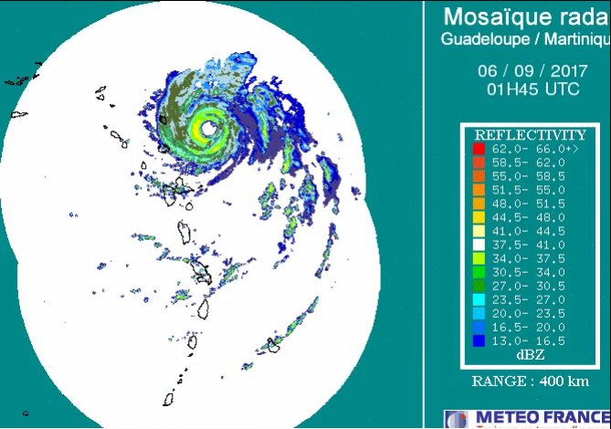
Another view... the two interference lines Aric mentioned are easily visible. Must be some obstruction to the radar.
http://www.meteo.fr/temps/domtom/antill ... f_com.html
1 likes
~Jeff
@meteoJeff
Meteorologist/Sr Technical Advisor at US Air Force
Patrick Space Force Base, FL
24th Analysis Squadron/Environmental Modeling and Simulation (EMS)
PhD in Meteorology, Florida Institute of Technology 2018
@meteoJeff
Meteorologist/Sr Technical Advisor at US Air Force
Patrick Space Force Base, FL
24th Analysis Squadron/Environmental Modeling and Simulation (EMS)
PhD in Meteorology, Florida Institute of Technology 2018
Re: ATL: IRMA - Hurricane - Discussion
EquusStorm wrote:Gatlinburg having been mentioned, I'm quite concerned about the potential impact at the national park in TN/NC; if the storm moves across central NC like some ensemble paths suspect, there would be a good bit of destructive wind there in the higher elevations. It is a gorgeous area. I know that Opal in 95 caused some pretty significant tree damage, knocking the top off the tallest tree east of the Rockies (was the only 200 foot tall tree on this half of the continent)
What are soil conditions like there? I remember that area having bad wildfires not too long ago, and if the vegetation hasn't grown back much since then, would there be a tendency toward landslide/mudslide if rain amounts were high?
0 likes

-
Bocadude85

- Category 5
- Posts: 2991
- Age: 39
- Joined: Mon Apr 18, 2005 2:20 pm
- Location: Honolulu,Hi
Re: ATL: IRMA - Hurricane - Discussion
Have the hurricane force winds extended a little farther south then the 5pm forecast advertised or has Irma been on a slightly more westerly track then originally forecast? The reason I ask this is because I just saw an 8:15pm update on the NHC site that has issued a hurricane warning for GUADELOUPE.
http://www.nhc.noaa.gov/text/refresh/MIATCUAT1+shtml/060039.shtml
http://www.nhc.noaa.gov/text/refresh/MIATCUAT1+shtml/060039.shtml
0 likes
-
doomhaMwx

- Category 5
- Posts: 2487
- Age: 27
- Joined: Tue Apr 18, 2017 4:01 am
- Location: Baguio/Benguet, Philippines
- Contact:
Re: ATL: IRMA - Hurricane - Discussion
Impressive VIIRS imagery of Category 5 Major Hurricane Irma east of the Leeward islands, taken @ Sept 05 5pm UTC...
Day/Night Visible Imagery VIIRS
09-05-2017 17:01

Day/Night Visible Imagery VIIRS
09-05-2017 17:01
6 likes

Re: ATL: IRMA - Hurricane - Discussion
Unless I'm mistaken, if it maintains 160kts it becomes the strongest hurricane landfall on record since it looks like it will cross Barbuda. Globally, it would tie Cyclone Winston and only be behind Haiyan.
0 likes
-
Aric Dunn
- Category 5
- Posts: 21238
- Age: 43
- Joined: Sun Sep 19, 2004 9:58 pm
- Location: Ready for the Chase.
- Contact:
Re: ATL: IRMA - Hurricane - Discussion
RL3AO wrote:Unless I'm mistaken, if it maintains 160kts it becomes the strongest hurricane landfall on record since it looks like it will cross Barbuda. Globally, it would tie Cyclone Winston and only be behind Haiyan.
wind wise .. yes. not even close on pressure.
0 likes
Note: If I make a post that is brief. Please refer back to previous posts for the analysis or reasoning. I do not re-write/qoute what my initial post said each time.
If there is nothing before... then just ask
Space & Atmospheric Physicist, Embry-Riddle Aeronautical University,
I believe the sky is falling...
If there is nothing before... then just ask
Space & Atmospheric Physicist, Embry-Riddle Aeronautical University,
I believe the sky is falling...
-
O Town
- S2K Supporter
- Posts: 5205
- Age: 52
- Joined: Wed Sep 07, 2005 9:37 pm
- Location: Orlando, Florida 28°35'35"N 81°22'55"W
Re: ATL: IRMA - Hurricane - Discussion
GCANE wrote:White Bay, Jost Van Dyke in the British Virgin Islands - Live from the Soggy Dollar Bar
Link: https://youtu.be/IjGdi7z_B4U
Links to either of the web cams you posted?
1 likes
#ORLANDOSTRONG
Re: ATL: IRMA - Hurricane - Discussion
Aric Dunn wrote:RL3AO wrote:Unless I'm mistaken, if it maintains 160kts it becomes the strongest hurricane landfall on record since it looks like it will cross Barbuda. Globally, it would tie Cyclone Winston and only be behind Haiyan.
wind wise .. yes. not even close on pressure.
Well for landfalls I'd argue winds is the pretty good metric to use.
1 likes

Re: ATL: IRMA - Hurricane - Discussion
Weather starting to go downhill in Aruba and Barbuda.
Edit: Antigua and Barbuda.
Edit: Antigua and Barbuda.
Last edited by NDG on Tue Sep 05, 2017 9:43 pm, edited 1 time in total.
0 likes
Re: ATL: IRMA - Hurricane - Discussion
NDG wrote:Weather starting to go downhill in Aruba and Barbuda.
Antigua. Aruba is in the southern Caribbean.
1 likes
-
Aric Dunn
- Category 5
- Posts: 21238
- Age: 43
- Joined: Sun Sep 19, 2004 9:58 pm
- Location: Ready for the Chase.
- Contact:
Re: ATL: IRMA - Hurricane - Discussion
RL3AO wrote:Aric Dunn wrote:RL3AO wrote:Unless I'm mistaken, if it maintains 160kts it becomes the strongest hurricane landfall on record since it looks like it will cross Barbuda. Globally, it would tie Cyclone Winston and only be behind Haiyan.
wind wise .. yes. not even close on pressure.
Well for landfalls I'd argue winds is the pretty good metric to use.
Agreed !! though during haiyan I heard of ear drums popping..
0 likes
Note: If I make a post that is brief. Please refer back to previous posts for the analysis or reasoning. I do not re-write/qoute what my initial post said each time.
If there is nothing before... then just ask
Space & Atmospheric Physicist, Embry-Riddle Aeronautical University,
I believe the sky is falling...
If there is nothing before... then just ask
Space & Atmospheric Physicist, Embry-Riddle Aeronautical University,
I believe the sky is falling...

Re: ATL: IRMA - Hurricane - Discussion
NDG wrote:Weather starting to go downhill in Aruba and Barbuda.
Aruba? You thinking of the Beach Boys song? The live cam of St Barth is starting to look really bad. I really feel for those in the thing's path.
2 likes
Personal Forecast Disclaimer:
The posts in this forum are NOT official forecast and should not be used as such. They are just the opinion of the poster and may or may not be backed by sound meteorological data. They are NOT endorsed by any professional institution or storm2k.org. For official information, please refer to the NHC and NWS products.
The posts in this forum are NOT official forecast and should not be used as such. They are just the opinion of the poster and may or may not be backed by sound meteorological data. They are NOT endorsed by any professional institution or storm2k.org. For official information, please refer to the NHC and NWS products.
Who is online
Users browsing this forum: No registered users and 9 guests