
Local NWS discussion
National Weather Service Tallahassee FL
646 AM EDT Thu May 24 2018
.LONG TERM [Saturday Night Through Thursday]...
A broad area of low pressure near the Yucatan Peninsula is
expected to move northward into the eastern/central Gulf of Mexico
on Saturday. As of yesterday evening, the National Hurricane
Center had a 70% that the disturbance will develop into a
tropical cyclone over the next 5 days. While models continue to
show differences in the track of the disturbance, the 00z models
at least trended towards each other slightly. Forecast for the
long term, leans towards the ECMWF track which takes the system
into the central Gulf of Mexico, as opposed to the GFS which has
had convective feedback influencing it and is further east.
Regardless of the exact track though, the system should lift
northward over the weekend and to the Gulf coast Sunday/Monday.
This will continue the wet forecast with the main focus of the
long term on the heavy rain potential. At this time, it appears
the greatest rainfall amounts would be in the Sunday to Monday
timeframe. Based on amounts (see hydrology section for details),
the flash flood threat will increase for the Sunday/Monday time
period.
HYDROLOGY...
Widespread 2-5" of rain has fallen over the last week and expect
an additional 3-7" over the next week with isolated higher
amounts. Isolated, minor flooding will be possible over the next
few days, but as a tropical disturbance lifts northward, the
threat for flash flooding will increase with the main focus at
this time Sunday into Monday. With differences still in the models
though, timing of the greater rainfall amounts and flash flood
focus is still subject to change. In regards to the flash flood
threat, have seen rises on area rivers with a few in action stage
or expected to reach action stage. In addition, the threat for
minor river flooding will increase late this weekend into next
The panhandle flooding could be an issue.
ATL: ALBERTO - Post-Tropical
Moderator: S2k Moderators
-
SFLcane

- S2K Supporter

- Posts: 10281
- Age: 48
- Joined: Sat Jun 05, 2010 1:44 pm
- Location: Lake Worth Florida
Re: ATL: INVEST 90L - Discussion : STWO=40%-80%
USTropics we can deal with those rain totals from the ecmwf we had triple just past 7-10 days. So a rainy weekend is no biggie. Looks like the heaviest flooding rains should stay over the gom.
0 likes

Re: ATL: INVEST 90L - Discussion : STWO=40%-80%
Here is SE Florida I think just light rain at the most it won’t be as bad as last weekend with those rain totals.
0 likes
-
PSUHiker31
- Tropical Storm

- Posts: 114
- Joined: Tue Oct 03, 2017 2:36 pm
Re: ATL: INVEST 90L - Models
Latest models are intriguing with an idea that this will grow to a strong tropical storm or minimal hurricane becoming more prevalent. Glad to see GFS joined the pack... But I also see that the HMON is just as lost as last year
0 likes
-
txwatcher91
- Category 5

- Posts: 1498
- Joined: Tue Aug 02, 2005 2:29 pm
Re: ATL: INVEST 90L - Discussion : STWO=40%-80%
[list=][/list]
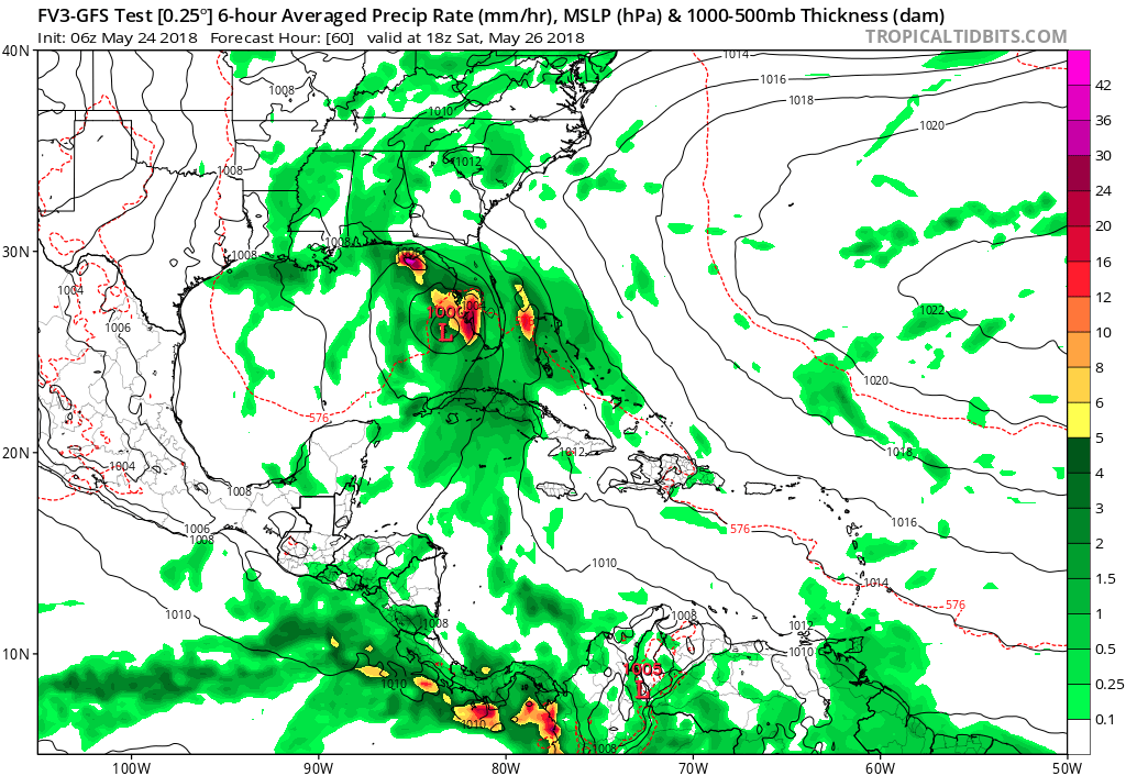
Those are 6 hour QPF totals, not storm total. CMC is showing storm totals of 6-9" of rain, GFS 3-5" and Euro 4-8" for most of Florida.
boca wrote:Here is SE Florida I think just light rain at the most it won’t be as bad as last weekend with those rain totals.
Those are 6 hour QPF totals, not storm total. CMC is showing storm totals of 6-9" of rain, GFS 3-5" and Euro 4-8" for most of Florida.
1 likes
-
USTropics
- Professional-Met

- Posts: 2738
- Joined: Sun Aug 12, 2007 3:45 am
- Location: Florida State University
Re: ATL: INVEST 90L - Discussion : STWO=40%-80%
SFLcane wrote:USTropics we can deal with those rain totals from the ecmwf we had triple just past 7-10 days. So a rainy weekend is no biggie. Looks like the heaviest flooding rains should stay over the gom.
Yea I was basically just looking at those with evening/outdoors plans for Memorial Day to prepare. I think a reasonable forecast, based on the models accumulated precipitation over the next 10 days, is for most of Florida to see an additional 3-4 inches of rain, with localized amounts nearing 6 inches. Model output has been pretty consistent with this, regardless of the true center location/track. Of course, if the GFS track pans out, the panhandle could see quite a bit more than that:
00z ECMWF 10 day total accumulated precipitation:

06z GFS 10 day total accumulated precipitation:

0 likes
-
Evil Jeremy

- S2K Supporter
- Posts: 5463
- Age: 32
- Joined: Mon Apr 10, 2006 2:10 pm
- Location: Los Angeles, CA
Re: ATL: INVEST 90L - Models
Looking better for the peninsula this morning, at the expense of the panhandle. Those GFS/ECMWF IR simulations still kick up an incredible amount of moisture into Florida. Won't be escaping downpours this weekend, but at least it's not going to be as bad as it could have. It will be interesting to see how strong 90L can get, but I can't imagine hurricane is a possibility with that much shear in the GOM.
0 likes
Frances 04 / Jeanne 04 / Katrina 05 / Wilma 05 / Fay 08 / Debby 12 / Andrea 13 / Colin 16 / Hermine 16 / Matthew 16 / Irma 17
-
AdamFirst

- S2K Supporter
- Posts: 2490
- Age: 36
- Joined: Thu Aug 14, 2008 10:54 am
- Location: Port Saint Lucie, FL
Re: ATL: INVEST 90L - Models
FWIW: The NAVGEM is now your eastern outlier, with the center hugging the west coast of Florida with entry around the big bend. A weak storm.
0 likes
Dolphins Marlins Canes Golden Panthers HEAT
Andrew 1992 - Irene 1999 - Frances 2004 - Jeanne 2004 - Wilma 2005 - Fay 2008 - Isaac 2012 - Matthew 2016 - Irma 2017 - Dorian 2019 - Ian 2022 - Nicole 2022 - Milton 2024
Andrew 1992 - Irene 1999 - Frances 2004 - Jeanne 2004 - Wilma 2005 - Fay 2008 - Isaac 2012 - Matthew 2016 - Irma 2017 - Dorian 2019 - Ian 2022 - Nicole 2022 - Milton 2024
-
cycloneye

- Admin

- Posts: 149389
- Age: 69
- Joined: Thu Oct 10, 2002 10:54 am
- Location: San Juan, Puerto Rico
Re: ATL: INVEST 90L - Models
12z SHIP has a moderate Tropical Storm.
Code: Select all
 * ATLANTIC     SHIPS INTENSITY FORECAST          *
                    * IR SAT DATA PROXY USED,      OHC AVAILABLE     *
                    *  INVEST      AL902018  05/24/18  12 UTC        *

TIME (HR)          0     6    12    18    24    36    48    60    72    84    96   108   120
V (KT) NO LAND    25    26    27    27    28    32    39    48    51    52    52    50    49
V (KT) LAND       25    26    26    29    30    34    40    50    44    32    29    31    27
V (KT) LGEM       25    26    26    26    29    28    29    30    27    27    27    32    29
Storm Type      TROP  TROP  TROP  TROP  TROP  TROP  TROP  TROP  TROP  TROP  TROP  TROP  TROP

SHEAR (KT)        28    27    29    30    27    26    18    15    12    21    17     6     9
SHEAR ADJ (KT)     3     1     5     3     0     2    -2     4    -4     1     3     1    -5
SHEAR DIR        272   265   256   261   263   236   264   203   259   265   302   236   265
SST (C)         28.2  28.1  28.1  28.1  28.1  28.1  27.7  25.6  25.5  24.5  27.2  26.5  23.3
POT. INT. (KT)   135   134   135   135   136   137   135   114   113   102   128   121    98
ADJ. POT. INT.   119   119   119   120   122   125   127   109   106    91   114   109    90
200 MB T (C)   -53.3 -53.1 -53.1 -53.7 -53.8 -53.1 -54.0 -53.5 -54.5 -53.6 -52.9 -52.5 -53.6
200 MB VXT (C)   0.5   0.6   0.7   0.8   0.4   0.6   0.3   0.2   0.4   0.9   1.2   1.1   1.3
TH_E DEV (C)       8     9     9     8     7     8     7     6     4    11     6     8     5
700-500 MB RH     63    62    64    65    65    69    69    72    74    52    44    57    65
MODEL VTX (KT)     8     9    10     9    10    13    18    23    24    24    24    20    19
850 MB ENV VOR     8    20    36    43    54    82    63    60    41    49    22    64    31
200 MB DIV        43    39    35    35    29    77    56    91     2    -8   -32    43    36
700-850 TADV       0    -1    -3     0     2     5    10    12     5     0     0     0     5
LAND (KM)        -76   -57   -27     3    45   100    44   170   -71  -189    -9   170  -230
LAT (DEG N)     19.3  19.4  19.5  19.5  19.5  20.4  22.2  26.0  30.7  32.3  29.6  28.9  32.3
LONG(DEG W)     88.2  88.0  87.7  87.4  87.0  86.1  84.9  83.8  85.2  88.7  89.8  86.9  85.1
STM SPEED (KT)     2     3     3     3     5     8    15    23    23    13    14    15    22
HEAT CONTENT      58    57    54    12    27    34    30     2     0     0    21     5     0

  FORECAST TRACK FROM TABM      INITIAL HEADING/SPEED (DEG/KT): 40/  2      CX,CY:   1/  2
  T-12 MAX WIND:  25            PRESSURE OF STEERING LEVEL (MB):  640  (MEAN=618)
  GOES IR BRIGHTNESS TEMP. STD DEV.  50-200 KM RAD:  20.3 (MEAN=14.5)
  % GOES IR PIXELS WITH T < -20 C    50-200 KM RAD:  32.0 (MEAN=65.0)
  PRELIM RI PROB (DV .GE. 55 KT IN 48 HR):            0.6

                        INDIVIDUAL CONTRIBUTIONS TO INTENSITY CHANGE
                         6   12   18   24   36   48   60   72   84   96  108  120
                        ----------------------------------------------------------
  SAMPLE MEAN CHANGE     1.   2.   3.   4.   6.   8.   9.  10.  11.  12.  13.  13.
  SST POTENTIAL          1.   1.   1.   2.   5.  10.  15.  18.  21.  23.  24.  25.
  VERTICAL SHEAR MAG     1.   1.   1.   1.  -0.  -3.  -5.  -6.  -9. -12. -12. -12.
  VERTICAL SHEAR ADJ    -0.  -0.  -1.  -1.  -1.  -0.  -1.   0.   0.   0.  -0.   0.
  VERTICAL SHEAR DIR    -0.  -1.  -1.  -1.  -2.  -3.  -4.  -3.  -3.  -2.  -2.  -1.
  PERSISTENCE           -0.  -1.  -1.  -1.  -1.  -1.  -1.  -1.  -0.   0.   0.   1.
  200/250 MB TEMP.      -0.  -0.  -0.  -0.  -1.  -1.  -1.  -1.  -1.  -1.  -1.  -1.
  THETA_E EXCESS         0.   0.   0.  -0.  -0.  -0.  -0.  -1.  -1.  -1.  -1.  -1.
  700-500 MB RH         -0.  -0.  -0.  -1.  -1.  -2.  -3.  -4.  -5.  -4.  -4.  -3.
  MODEL VTX TENDENCY     0.   1.   1.   1.   4.   9.  17.  17.  16.  16.  11.   7.
  850 MB ENV VORTICITY  -0.  -0.  -0.   0.   0.   1.   1.   1.   1.   1.   2.   2.
  200 MB DIVERGENCE      0.   0.   0.   0.   0.   0.   1.   1.   1.   0.   0.  -0.
  850-700 T ADVEC        0.  -0.  -0.  -0.  -0.  -0.   0.   0.   0.   0.   0.   0.
  ZONAL STORM MOTION     0.  -0.  -0.  -0.  -1.  -1.  -1.  -2.  -2.  -3.  -3.  -4.
  STEERING LEVEL PRES   -0.  -0.  -0.  -0.  -0.  -0.  -0.  -0.  -0.  -0.  -0.  -0.
  DAYS FROM CLIM. PEAK   0.   0.   0.   0.   0.   0.   1.   1.   1.   2.   2.   2.
  GOES PREDICTORS       -1.  -1.  -1.  -2.  -3.  -3.  -4.  -4.  -4.  -3.  -3.  -3.
  OCEAN HEAT CONTENT    -0.  -0.  -0.  -0.  -0.  -1.  -1.  -1.  -1.  -1.  -1.  -0.
                        ----------------------------------------------------------
  TOTAL CHANGE           1.   2.   2.   3.   7.  14.  23.  26.  27.  27.  25.  24.

                CURRENT MAX WIND (KT):   25. LAT, LON:   19.3    88.2

      ** 2017 ATLANTIC RI INDEX AL902018 INVEST     05/24/18  12 UTC **
 (SHIPS-RII PREDICTOR TABLE for 30 KT OR MORE MAXIMUM WIND INCREASE IN NEXT 24-h)

     Predictor             Value   RI Predictor Range  Scaled Value(0-1) % Contribution
 12 HR PERSISTENCE (KT):     0.0     -49.5  to   33.0       0.60         999.0
 850-200 MB SHEAR (KT) :    28.4      30.1  to    2.9       0.06         999.0
 HEAT CONTENT (KJ/cm2) :    41.6       0.0  to  156.2       0.27         999.0
 2nd PC OF IR BR TEMP  :  9999.0       2.4  to   -3.0     999.00         999.0
 STD DEV OF IR BR TEMP :   999.0      36.6  to    2.8     999.00         999.0
 MAXIMUM WIND (kt)     :    25.0      22.5  to  121.0       0.07         999.0
 POT = MPI-VMAX (KT)   :    94.7      28.4  to  139.6       0.60         999.0
 D200 (10**7s-1)       :    36.2     -29.7  to  181.5       0.31         999.0
 BL DRY-AIR FLUX (w/m2):    94.6     961.4  to  -67.1       0.84         999.0
 % AREA WITH TPW <45 mm:     7.1     100.0  to    0.0       0.93         999.0

 SHIPS Prob RI for 20kt/ 12hr RI threshold= 999% is 999.0 times sample mean ( 5.4%)
 SHIPS Prob RI for 25kt/ 24hr RI threshold= 999% is 999.0 times sample mean (11.5%)
 SHIPS Prob RI for 30kt/ 24hr RI threshold= 999% is 999.0 times sample mean ( 7.4%)
 SHIPS Prob RI for 35kt/ 24hr RI threshold= 999% is 999.0 times sample mean ( 4.3%)
 SHIPS Prob RI for 40kt/ 24hr RI threshold= 999% is 999.0 times sample mean ( 2.8%)
 SHIPS Prob RI for 45kt/ 36hr RI threshold= 999% is 999.0 times sample mean ( 5.1%)
 SHIPS Prob RI for 55kt/ 48hr RI threshold= 999% is 999.0 times sample mean ( 5.3%)
 SHIPS Prob RI for 65kt/ 72hr RI threshold= 999% is 999.0 times sample mean ( 6.0%)

Matrix of RI probabilities
------------------------------------------------------------------------------
  RI (kt / h)  | 20/12 | 25/24 | 30/24 | 35/24 | 40/24 | 45/36 | 55/48  |65/72
------------------------------------------------------------------------------
   SHIPS-RII:   999.0%  999.0%  999.0%  999.0%  999.0%  999.0%  999.0%  999.0%
    Logistic:   999.0%  999.0%  999.0%  999.0%  999.0%  999.0%  999.0%  999.0%
    Bayesian:   999.0%  999.0%  999.0%  999.0%  999.0%  999.0%  999.0%  999.0%
   Consensus:   999.0%  999.0%  999.0%  999.0%  999.0%  999.0%  999.0%  999.0%

   ##         ANNULAR HURRICANE INDEX (AHI) AL902018 INVEST     05/24/18  12 UTC         ##
   ##         ERR=2, BOTH IR FILES BAD OR MISSING

** PROBLTY OF AT LEAST 1 SCNDRY EYEWL FORMTN EVENT AL902018 INVEST     05/24/2018  12 UTC **
TIME(HR)   0-12  12-24(0-24)  24-36(0-36)  36-48(0-48)
CLIMO(%)     0      0(  0)       0(  0)       0(  0)     <-- PROB BASED ON INTENSITY ONLY
PROB(%)      0      0(  0)       0(  0)       0(  0)     PC4 UNAVAIL...MODEL SKILL DEGRADED

** DSHIPS INTENSITY FORECAST ADJUSTED RELATIVE TO ONSET OF ERC WEAKENING PHASE **
      TIME (HR)      0     6    12    18    24    36    48    60    72    84    96   108   120
>24HR AGO (DSHIPS)  25    26    26    29    30    34    40    50    44    32    29    31    27
 18HR AGO           25    24    24    27    28    32    38    48    42    30    27    29    25
 12HR AGO           25    22    21    24    25    29    35    45    39    27    24    26    22
  6HR AGO           25    19    16    15    16    20    26    36    30    18    15    17   DIS
      NOW                              CURRENT INTENSITY < 83 KT
  IN  6HR                              INTENSITY IN  6HR < 83 KT
  IN 12HR                              INTENSITY IN 12HR < 83 KT
0 likes
Visit the Caribbean-Central America Weather Thread where you can find at first post web cams,radars
and observations from Caribbean basin members Click Here
and observations from Caribbean basin members Click Here

Re: ATL: INVEST 90L - Models
NDG wrote::uarrow: It never fails, most times when the GFS & Euro are so far apart they end up trending towards each other.
Yes I agree, that is what I have seen. I don't think one model busted over the other. In the end they start averaging out. I am still sticking with Big Bend Area because I think the COC will be further east when it emerges in the S. Gulf due to it being drawn closer to the deeper convection.
2 likes
The following post is NOT an official forecast and should not be used as such. It is just the opinion of the poster and may or may not be backed by sound meteorological data. It is NOT endorsed by any professional institution including storm2k.org For Official Information please refer to the NHC and NWS products.
-
cycloneye
- Admin
- Posts: 149389
- Age: 69
- Joined: Thu Oct 10, 2002 10:54 am
- Location: San Juan, Puerto Rico
Re: ATL: INVEST 90L - Discussion : STWO=40%-80%
12z Best Track:
Location: 19.3°N 88.2°W
Maximum Winds: 25 kt
Minimum Central Pressure: 1009 mb

Location: 19.3°N 88.2°W
Maximum Winds: 25 kt
Minimum Central Pressure: 1009 mb
0 likes
Visit the Caribbean-Central America Weather Thread where you can find at first post web cams,radars
and observations from Caribbean basin members Click Here
and observations from Caribbean basin members Click Here
-
SouthDadeFish

- Professional-Met
- Posts: 2835
- Joined: Thu Sep 23, 2010 2:54 pm
- Location: Miami, FL
- Contact:
Re: ATL: INVEST 90L - Discussion : STWO=40%-80%
I think the upper-tropospheric trough evolution will be key in determining whether or not TC genesis occurs and how much intensification follows. If the trough is configured in a way such that forcing for ascent is focused near and even upstream of the TC/disturbance center, genesis and intensification are much more likely. Regardless, with the upper-tropospheric trough present, heavy rainfall is essentially guaranteed.
4 likes
-
cycloneye
- Admin
- Posts: 149389
- Age: 69
- Joined: Thu Oct 10, 2002 10:54 am
- Location: San Juan, Puerto Rico
Re: ATL: INVEST 90L - Discussion : STWO=40%-80%
0 likes
Visit the Caribbean-Central America Weather Thread where you can find at first post web cams,radars
and observations from Caribbean basin members Click Here
and observations from Caribbean basin members Click Here
Re: ATL: INVEST 90L - Discussion : STWO=40%-80%
Mid level circ has been tightening up in the last few hours. Will it be able to pull the LLC off the Yucatan.

0 likes
The following post is NOT an official forecast and should not be used as such. It is just the opinion of the poster and may or may not be backed by sound meteorological data. It is NOT endorsed by any professional institution including storm2k.org For Official Information please refer to the NHC and NWS products.

Re: ATL: INVEST 90L - Models
blp wrote:NDG wrote::uarrow: It never fails, most times when the GFS & Euro are so far apart they end up trending towards each other.
Yes I agree, that is what I have seen. I don't think one model busted over the other. In the end they start averaging out. I am still sticking with Big Bend Area because I think the COC will be further east when it emerges in the S. Gulf due to it being drawn closer to the deeper convection.
We really don't know if one or the other will since the low pressure is still on the Yucatan. The GFS clearly had its own ideas in runs the last few days. The ECMWF was allied with JMA, German model and occasionally the NAM and ICON. Others mostly split the difference. I didn't think the GFS would pan out despite climatology and setup and a pretty emphatic endorsement from some of our best professional meteorologists who may still be right (though the GFS has trended away from what they said was likely to happen). Though the tropics behave according to science, we aren't far enough along yet to understand it all or to program our models to understand it all. We have come pretty far in the last few decades, but we still have a long way to go.
3 likes
Re: ATL: INVEST 90L - Models
Personally any talk of models busting is premature when the center isn't really obvious yet and the best track being over land. Despite that I'm thinking somewhere between Biloxi and Panama City Beach, with everything lopsided to the east.
3 likes
-
Evil Jeremy
- S2K Supporter
- Posts: 5463
- Age: 32
- Joined: Mon Apr 10, 2006 2:10 pm
- Location: Los Angeles, CA
Re: ATL: INVEST 90L - Discussion : STWO=40%-80%
blp wrote:Mid level circ has been tightening up in the last few hours. Will it be able to pull the LLC off the Yucatan.
https://i.imgur.com/Nm0hIu7.gif
I can’t link it at the moment but I just checked the 850mb vorticity, and the highest concentration seems to have moved from inland Yucatan to just off the east coast.
0 likes
Frances 04 / Jeanne 04 / Katrina 05 / Wilma 05 / Fay 08 / Debby 12 / Andrea 13 / Colin 16 / Hermine 16 / Matthew 16 / Irma 17
-
cycloneye
- Admin
- Posts: 149389
- Age: 69
- Joined: Thu Oct 10, 2002 10:54 am
- Location: San Juan, Puerto Rico
Re: ATL: INVEST 90L - Models
@MJVentrice
I strongly believe that models will better align with invest #90L on track and intensity once this storm pushes off the Yucatan on Saturday. Until then, there is still room for change in the models.
https://twitter.com/MJVentrice/status/999642080367529984
I strongly believe that models will better align with invest #90L on track and intensity once this storm pushes off the Yucatan on Saturday. Until then, there is still room for change in the models.
https://twitter.com/MJVentrice/status/999642080367529984
0 likes
Visit the Caribbean-Central America Weather Thread where you can find at first post web cams,radars
and observations from Caribbean basin members Click Here
and observations from Caribbean basin members Click Here
-
gatorcane

- S2K Supporter
- Posts: 23708
- Age: 48
- Joined: Sun Mar 13, 2005 3:54 pm
- Location: Boca Raton, FL
Re: ATL: INVEST 90L - Discussion
I am a bit surprised the overnight models have gone more bullish with all of the shear in the GOM and the last 06Z GFS run shifted considerably west. I am guessing since 90L is more organized right now than models previously thought, the models are responding accordingly. Blend of ECMWF and GFS looks to be the best track at this point.
0 likes
Who is online
Users browsing this forum: No registered users and 52 guests