ATL: ALBERTO - Post-Tropical
Moderator: S2k Moderators
-
gatorcane

- S2K Supporter

- Posts: 23708
- Age: 48
- Joined: Sun Mar 13, 2005 3:54 pm
- Location: Boca Raton, FL
Re: ATL: INVEST 90L - Models
And just when you think we have model agreement between the GFS and EC you end up with this run to add further uncertainty putting us almost back to where we were 24 hours ago with the models. The 18Z GFS looks a lot like the 12Z FV3 GFS run actually. I certainly wouldn’t discount it seeing how the UKMET is similar albeit a bit more east.
Last edited by gatorcane on Thu May 24, 2018 5:45 pm, edited 3 times in total.
0 likes
Re: ATL: INVEST 90L - Models
PSUHiker31 wrote:Well at least the 12Z GFS was reasonable. That 18Z run is garbage.
GFS in totality so far has not been bad but I would caution those declaring one model over another to wait for an offical LLC and final outcome
0 likes
-
GumboCane83

- Tropical Wave

- Posts: 9
- Joined: Fri Oct 06, 2017 9:27 pm

-
Sciencerocks
- Category 5

- Posts: 10186
- Age: 40
- Joined: Thu Jul 06, 2017 1:51 am
Re: ATL: INVEST 90L - Discussion
GumboCane83 wrote:Is south central Louisiana out of the equation?
No! Quite a few of the models take it quite close to Louisiana and even stall it near the state.
0 likes
-
Hurricaneman

- Category 5
- Posts: 7404
- Age: 45
- Joined: Tue Aug 31, 2004 3:24 pm
- Location: central florida
Re: ATL: INVEST 90L - Discussion
GumboCane83 wrote:Is south central Louisiana out of the equation?
Nope, and I wouldn’t call the all clear from Houston to Key West as of yet
0 likes
-
toad strangler

- S2K Supporter
- Posts: 4546
- Joined: Sun Jul 28, 2013 3:09 pm
- Location: Earth
- Contact:
Re: ATL: INVEST 90L - Models
caneman wrote:PSUHiker31 wrote:Well at least the 12Z GFS was reasonable. That 18Z run is garbage.
GFS in totality so far has not been bad but I would caution those declaring one model over another to wait for an offical LLC and final outcome
Models are just tools to begin with. Sometimes real climatology and meteorology get stuffed in the closet in favor of AI eye candy.
I’m really liking a 2013 Andrea analog here all things considered.
0 likes
My Weather Station
https://www.wunderground.com/dashboard/pws/KFLPORTS603
https://www.wunderground.com/dashboard/pws/KFLPORTS603
-
cycloneye

- Admin

- Posts: 149392
- Age: 69
- Joined: Thu Oct 10, 2002 10:54 am
- Location: San Juan, Puerto Rico
Re: ATL: INVEST 90L - Discussion
7 likes
Visit the Caribbean-Central America Weather Thread where you can find at first post web cams,radars
and observations from Caribbean basin members Click Here
and observations from Caribbean basin members Click Here
-
Dylan

- Professional-Met

- Posts: 338
- Age: 31
- Joined: Mon May 31, 2010 9:50 am
- Location: New Orleans, LA
Re: ATL: INVEST 90L - Discussion
Latest update on 90L up on my Facebook: https://www.facebook.com/DylanFedericoW ... 2245847420
THURSDAY PM UPDATE ON INVEST 90L
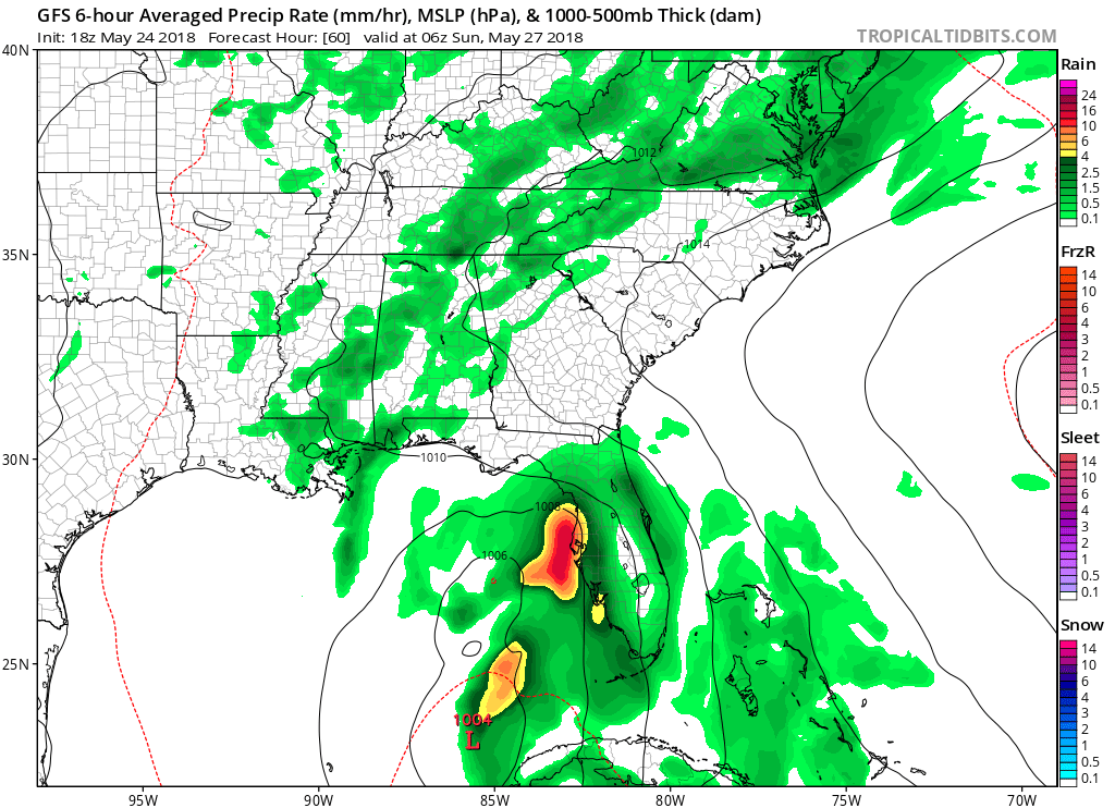
#90L remains a broad area of low pressure this evening, with an area of convection on its eastern side. Though, it continues to show signs of gradual organization with a slightly better defined surface low, along with more concentrated thunderstorm activity on its eastern side. 90L is currently located along the eastern Yucatan Peninsula coastline, slowly sliding north. The National Hurricane Center now gives the disturbance a “High Chance” (90%) of becoming at least a tropical depression over the next 5 days. With development almost a certainty at this point, it’s time to start evaluating your vacation plans if you plan on going to the Mississippi, Alabama, or Florida Coast this weekend.
Over the past 24 hours, models have come into better consensus on where 90L will eventually end up going. General consensus is that the disturbance will slowly slide northward towards the north-central gulf coast over the next several days along the western periphery of the Bermuda high. However, there is some spread, with the 12z GFS, CMC, and EURO showing landfall from SE Louisiana to the Mississippi/Alabama border. The GFS/EURO ensembles from this afternoon also show a spread from SE LA to the Florida panhandle beaches. Upon approach to the coast, steering currents could significantly weaken, leading to great uncertainty of where 90L will go after Tuesday.
90L is currently fighting wind shear, dry air, and land interaction. Over the next couple of days, guidance shows conditions becoming marginally favorable for strengthening, with some hints that it could be quite conducive for strengthening as 90L moves into the northern Gulf of Mexico this weekend. Additionally, water temperatures are well above normal in the Gulf of Mexico, and this certainly could be a factor in the system overachieving compared to current forecasts. For now, I wouldn’t bet on anything more than a tropical storm, considering hurricanes in the Gulf in May are almost unheard of.
With that said, with this system expected to stay relatively weak, the main threat that I’m monitoring for is heavy rainfall totals. Particularly in Mississippi, Alabama, Florida, and Georgia which will almost certainly be on the eastern side of the system. Extreme eastern Louisiana could also see heavy rainfall totals, but highly depends on the exact track of the system. It would need to go further west than forecasted for the current rainfall forecasts to increase. Those on the eastern side of the storm could easily see 12+ inches of rain, and possibly significantly higher totals if this system stalls, or does a loop near the coast. Stay tuned!
THURSDAY PM UPDATE ON INVEST 90L
#90L remains a broad area of low pressure this evening, with an area of convection on its eastern side. Though, it continues to show signs of gradual organization with a slightly better defined surface low, along with more concentrated thunderstorm activity on its eastern side. 90L is currently located along the eastern Yucatan Peninsula coastline, slowly sliding north. The National Hurricane Center now gives the disturbance a “High Chance” (90%) of becoming at least a tropical depression over the next 5 days. With development almost a certainty at this point, it’s time to start evaluating your vacation plans if you plan on going to the Mississippi, Alabama, or Florida Coast this weekend.
Over the past 24 hours, models have come into better consensus on where 90L will eventually end up going. General consensus is that the disturbance will slowly slide northward towards the north-central gulf coast over the next several days along the western periphery of the Bermuda high. However, there is some spread, with the 12z GFS, CMC, and EURO showing landfall from SE Louisiana to the Mississippi/Alabama border. The GFS/EURO ensembles from this afternoon also show a spread from SE LA to the Florida panhandle beaches. Upon approach to the coast, steering currents could significantly weaken, leading to great uncertainty of where 90L will go after Tuesday.
90L is currently fighting wind shear, dry air, and land interaction. Over the next couple of days, guidance shows conditions becoming marginally favorable for strengthening, with some hints that it could be quite conducive for strengthening as 90L moves into the northern Gulf of Mexico this weekend. Additionally, water temperatures are well above normal in the Gulf of Mexico, and this certainly could be a factor in the system overachieving compared to current forecasts. For now, I wouldn’t bet on anything more than a tropical storm, considering hurricanes in the Gulf in May are almost unheard of.
With that said, with this system expected to stay relatively weak, the main threat that I’m monitoring for is heavy rainfall totals. Particularly in Mississippi, Alabama, Florida, and Georgia which will almost certainly be on the eastern side of the system. Extreme eastern Louisiana could also see heavy rainfall totals, but highly depends on the exact track of the system. It would need to go further west than forecasted for the current rainfall forecasts to increase. Those on the eastern side of the storm could easily see 12+ inches of rain, and possibly significantly higher totals if this system stalls, or does a loop near the coast. Stay tuned!
4 likes
Georges('98), Allison('01), Isidore('02), Lili('02), Frances('04) Ivan('04), Cindy('05), Katrina('05), Rita('05), Gustav('08), Isaac('12), Matthew('16), Harvey('17), Irma('17), Nate ('17), Ida ('21).
-
PSUHiker31
- Tropical Storm

- Posts: 114
- Joined: Tue Oct 03, 2017 2:36 pm
Re: ATL: INVEST 90L - Models
caneman wrote:PSUHiker31 wrote:Well at least the 12Z GFS was reasonable. That 18Z run is garbage.
GFS in totality so far has not been bad but I would caution those declaring one model over another to wait for an offical LLC and final outcome
The feedback is horrible and obvious on that run
0 likes
-
AdamFirst

- S2K Supporter
- Posts: 2490
- Age: 36
- Joined: Thu Aug 14, 2008 10:54 am
- Location: Port Saint Lucie, FL
Re: ATL: INVEST 90L - Models
There must have been some new data ingested with this model suite to suggest these weakening trends.
1 likes
Dolphins Marlins Canes Golden Panthers HEAT
Andrew 1992 - Irene 1999 - Frances 2004 - Jeanne 2004 - Wilma 2005 - Fay 2008 - Isaac 2012 - Matthew 2016 - Irma 2017 - Dorian 2019 - Ian 2022 - Nicole 2022 - Milton 2024
Andrew 1992 - Irene 1999 - Frances 2004 - Jeanne 2004 - Wilma 2005 - Fay 2008 - Isaac 2012 - Matthew 2016 - Irma 2017 - Dorian 2019 - Ian 2022 - Nicole 2022 - Milton 2024

Re: ATL: INVEST 90L - Discussion
Levi rules. Look Saturday into Sunday at how the Gulf of Mexico trough amplifies and how far negatively tilted it is. That’s the likely path. The amplification looks to be the result of a squeeze from high(er) pressure to the north, east and west.
4 likes
Re: ATL: INVEST 90L - Models
the IR from the HWRF suggests an extratropical storm, not a tropical storm. Looks like an occluded front develops as it approaches the coast
1 likes
-
cycloneye
- Admin
- Posts: 149392
- Age: 69
- Joined: Thu Oct 10, 2002 10:54 am
- Location: San Juan, Puerto Rico
Re: ATL: INVEST 90L - Discussion: STWO - 70%-90%
Special Tropical Weather Outlook
NWS National Hurricane Center Miami FL
725 PM EDT Thu May 24 2018
For the North Atlantic...Caribbean Sea and the Gulf of Mexico:
A broad surface low drifting slowly northward over the eastern
Yucatan Peninsula has become better defined since yesterday,
although the associated associated shower and thunderstorm activity
is poorly organized due to strong upper-level winds. However,
environmental conditions are forecast to become more conducive for
development, and a subtropical or tropical depression or storm is
likely to form during the weekend over the eastern or central Gulf
of Mexico. Please see high seas forecasts issued by the National
Weather Service for information on gale warnings associated with
this system. An Air Force Reserve reconnaissance aircraft is
scheduled to investigate the disturbance Friday afternoon, if
necessary. Locally heavy rainfall is forecast across western Cuba
and over much of Florida and the northern Gulf Coast into early next
week. In addition, the threat of rip currents will steadily
increase along the Gulf coast from Florida westward to Louisiana
over the Memorial Day weekend. For more information on these
threats, please see products issued by your local weather office.
The next Special Tropical Weather Outlook on this system will be
issued by 200 AM EDT Friday morning.
* Formation chance through 48 hours...high...70 percent.
* Formation chance through 5 days...high...90 percent.
$$
Forecaster Beven
1 likes
Visit the Caribbean-Central America Weather Thread where you can find at first post web cams,radars
and observations from Caribbean basin members Click Here
and observations from Caribbean basin members Click Here
-
toad strangler
- S2K Supporter
- Posts: 4546
- Joined: Sun Jul 28, 2013 3:09 pm
- Location: Earth
- Contact:
Re: ATL: INVEST 90L - Discussion
Superb update from Levi
4 likes
My Weather Station
https://www.wunderground.com/dashboard/pws/KFLPORTS603
https://www.wunderground.com/dashboard/pws/KFLPORTS603
-
gatorcane
- S2K Supporter
- Posts: 23708
- Age: 48
- Joined: Sun Mar 13, 2005 3:54 pm
- Location: Boca Raton, FL
Re: ATL: INVEST 90L - Models
Looks like the HWRF also shifted east closer to west coast of Florida. Things seem to be trending a bit toward the UKMET which is weaker and more east.
0 likes
-
SouthFloridawx

- S2K Supporter
- Posts: 8346
- Age: 47
- Joined: Tue Jul 26, 2005 1:16 am
- Location: Sarasota, FL
- Contact:
Re: ATL: INVEST 90L - Models
Could it be possible that it remains a sheared mess, with multiple vort's through the next 48 hours or more? Instead of an organized system, doesn't it makes sense? We were watching this thing last night almost into the BOC. Now it's back over the eastern Yucatan.
0 likes
Re: ATL: INVEST 90L - Models
PSUHiker31 wrote:caneman wrote:PSUHiker31 wrote:Well at least the 12Z GFS was reasonable. That 18Z run is garbage.
GFS in totality so far has not been bad but I would caution those declaring one model over another to wait for an offical LLC and final outcome
The feedback is horrible and obvious on that run
Even a blind squirrel gets a nut once in awhile and it does have other model support along with climatology
0 likes
-
johngaltfla

- Category 5
- Posts: 2073
- Joined: Sun Jul 10, 2005 9:17 pm
- Location: Sarasota County, FL
- Contact:
Re: ATL: INVEST 90L - Models
gatorcane wrote:Looks like the HWRF also shifted east closer to west coast of Florida. Things seem to be trending a bit toward the UKMET which is weaker and more east.
IMHO, last season the UKMET was much better on non-developed tropical systems than most models. I'll be curious to see if it verifies with this storm because it means the tweaks they made were superb and might make it the model to follow as systems start to develop.
1 likes
-
stormlover2013
Who is online
Users browsing this forum: No registered users and 22 guests