2018 Tropics: Global Model Runs Discussion (Out to day 16)
Moderator: S2k Moderators
Forum rules

The posts in this forum are NOT official forecasts and should not be used as such. They are just the opinion of the poster and may or may not be backed by sound meteorological data. They are NOT endorsed by any professional institution or STORM2K. For official information, please refer to products from the National Hurricane Center and National Weather Service.
-
Aric Dunn
- Category 5

- Posts: 21238
- Age: 43
- Joined: Sun Sep 19, 2004 9:58 pm
- Location: Ready for the Chase.
- Contact:
Re: 2018 Tropics: Global Model Runs Discussion (Out to day 16)
Even less on the 12z Euro ..lol
0 likes
Note: If I make a post that is brief. Please refer back to previous posts for the analysis or reasoning. I do not re-write/qoute what my initial post said each time.
If there is nothing before... then just ask
Space & Atmospheric Physicist, Embry-Riddle Aeronautical University,
I believe the sky is falling...
If there is nothing before... then just ask
Space & Atmospheric Physicist, Embry-Riddle Aeronautical University,
I believe the sky is falling...

Re: 2018 Tropics: Global Model Runs Discussion (Out to day 16)
The trend has been even for the GFS is that ridging moving in from the tropical Atlantic into the Caribbean next week is trending stronger so I feel confident that even if the GFS & CMC are correct this is a TX/LA problem maybe even just a MX problem, may not be nothing for us here in FL to worry about. IMO.
Last edited by NDG on Sat Jun 09, 2018 1:21 pm, edited 1 time in total.
1 likes
Re: 2018 Tropics: Global Model Runs Discussion (Out to day 16)
My expectation is as follows: when the dust settles this will be another feather in the cap of the sticky that prohibits threads on modelstorms.
1 likes
-
Aric Dunn
- Category 5
- Posts: 21238
- Age: 43
- Joined: Sun Sep 19, 2004 9:58 pm
- Location: Ready for the Chase.
- Contact:
Re: 2018 Tropics: Global Model Runs Discussion (Out to day 16)
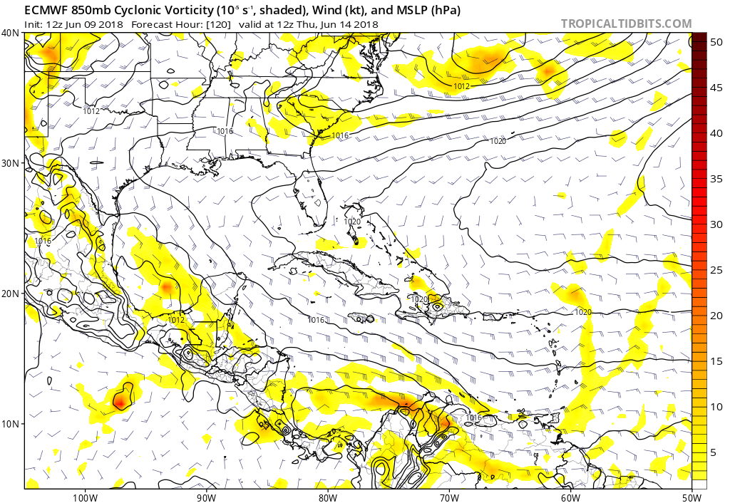
wait Euro almost develops something heading through the western gulf..
you can follow the vorticity from the SW carrib -- gulf of Honduras-- bay of Campeche then approaching texas with a closed isobar lol
so that is a first.. yay euro.. lol
you can follow the vorticity from the SW carrib -- gulf of Honduras-- bay of Campeche then approaching texas with a closed isobar lol
so that is a first.. yay euro.. lol
4 likes
Note: If I make a post that is brief. Please refer back to previous posts for the analysis or reasoning. I do not re-write/qoute what my initial post said each time.
If there is nothing before... then just ask
Space & Atmospheric Physicist, Embry-Riddle Aeronautical University,
I believe the sky is falling...
If there is nothing before... then just ask
Space & Atmospheric Physicist, Embry-Riddle Aeronautical University,
I believe the sky is falling...
-
gatorcane

- S2K Supporter

- Posts: 23708
- Age: 48
- Joined: Sun Mar 13, 2005 3:54 pm
- Location: Boca Raton, FL
Re: 2018 Tropics: Global Model Runs Discussion (Out to day 16)
A very weak area of vorticity on the Euro in the Boc yes - but the Euro insists no development and that is day 5 we are talking about so not long-range:
0 likes
-
Haris

- Category 5
- Posts: 1814
- Joined: Mon Nov 27, 2017 8:19 pm
- Location: ( Bee Cave) West Austin, Texas
Re: 2018 Tropics: Global Model Runs Discussion (Out to day 16)
euro trended 2% towards the GFS.
At this point , a mix of the both and a weak TS is poss
At this point , a mix of the both and a weak TS is poss
1 likes
Weather geek and a storm spotter in West Austin. Not a degreed meteorologist. Big snow fan. Love rain and cold! Despise heat!
Re: 2018 Tropics: Global Model Runs Discussion (Out to day 16)
EC for the first time has a weak low going into northern Mexico
4 likes
-
Aric Dunn
- Category 5
- Posts: 21238
- Age: 43
- Joined: Sun Sep 19, 2004 9:58 pm
- Location: Ready for the Chase.
- Contact:
Re: 2018 Tropics: Global Model Runs Discussion (Out to day 16)
substantial convection through the trip from the SW carrib. pretty easy to see something more substantial come out of that from the EURO.

0 likes
Note: If I make a post that is brief. Please refer back to previous posts for the analysis or reasoning. I do not re-write/qoute what my initial post said each time.
If there is nothing before... then just ask
Space & Atmospheric Physicist, Embry-Riddle Aeronautical University,
I believe the sky is falling...
If there is nothing before... then just ask
Space & Atmospheric Physicist, Embry-Riddle Aeronautical University,
I believe the sky is falling...
-
USTropics
- Professional-Met

- Posts: 2738
- Joined: Sun Aug 12, 2007 3:45 am
- Location: Florida State University
Re: 2018 Tropics: Global Model Runs Discussion (Out to day 16)
Meanwhile, the UKMET continues to advertise lowering pressures in the EPAC. Past runs have shown weak development of a 3rd system (behind BUD), but gradually runs have shown a weaker and weaker area of low pressure that has gravitated towards CA:

0 likes
-
stormreader
Re: 2018 Tropics: Global Model Runs Discussion (Out to day 16)
gatorcane wrote:A very weak area of vorticity on the Euro in the Boc yes - but the Euro insists no development and that is day 5 we are talking about so not long-range:
Euro beginning to see the light?? Also, notice how far south and west the Euro puts the system (in the BOC)....so it's not impressive at all. EPAC monsoonal already in full swing, so that makes sense. But if the system (which the Euro has been late to acknowledge) does form further east, then you might expect a more pronounced system coming off the Yucatan and in the central GOM (perhaps??)
1 likes
-
Aric Dunn
- Category 5
- Posts: 21238
- Age: 43
- Joined: Sun Sep 19, 2004 9:58 pm
- Location: Ready for the Chase.
- Contact:
Re: 2018 Tropics: Global Model Runs Discussion (Out to day 16)
Im JB is starting to freak out now.. its story time.. 
0 likes
Note: If I make a post that is brief. Please refer back to previous posts for the analysis or reasoning. I do not re-write/qoute what my initial post said each time.
If there is nothing before... then just ask
Space & Atmospheric Physicist, Embry-Riddle Aeronautical University,
I believe the sky is falling...
If there is nothing before... then just ask
Space & Atmospheric Physicist, Embry-Riddle Aeronautical University,
I believe the sky is falling...
-
Haris
- Category 5
- Posts: 1814
- Joined: Mon Nov 27, 2017 8:19 pm
- Location: ( Bee Cave) West Austin, Texas
Re: 2018 Tropics: Global Model Runs Discussion (Out to day 16)
euro trended ALOT wetter for tx and highs in the 70s! Best case scenario
2 likes
Weather geek and a storm spotter in West Austin. Not a degreed meteorologist. Big snow fan. Love rain and cold! Despise heat!
-
Aric Dunn
- Category 5
- Posts: 21238
- Age: 43
- Joined: Sun Sep 19, 2004 9:58 pm
- Location: Ready for the Chase.
- Contact:
Re: 2018 Tropics: Global Model Runs Discussion (Out to day 16)
ALso the GFS MJO Forecast was pretty much dead on.. we are going favorably now and very favorable by middle next week..
0 likes
Note: If I make a post that is brief. Please refer back to previous posts for the analysis or reasoning. I do not re-write/qoute what my initial post said each time.
If there is nothing before... then just ask
Space & Atmospheric Physicist, Embry-Riddle Aeronautical University,
I believe the sky is falling...
If there is nothing before... then just ask
Space & Atmospheric Physicist, Embry-Riddle Aeronautical University,
I believe the sky is falling...
-
Dean4Storms
- S2K Supporter
- Posts: 6358
- Age: 63
- Joined: Sun Aug 31, 2003 1:01 pm
- Location: Miramar Bch. FL
Re: 2018 Tropics: Global Model Runs Discussion (Out to day 16)
Taking a look at SST’s the SW Gulf is some of the warmest SST’s currently in the whole Atlantic basin running between 29.5 and 30C. SST’s between 28.5 and 29.5C cover the whole western Gulf from the Yuc. Peninsula northward. Unless shear or dry air is worse than what Alberto dealt with I don’t see any reasonable reason why any low at the surface or sustained deep convection would not have a good shot at significant development once over the western Gulf.
This is my own opinion and certainly not an official forecast.
This is my own opinion and certainly not an official forecast.
3 likes
-
bamajammer4eva
- Category 4

- Posts: 907
- Joined: Sun Apr 18, 2010 3:21 am
- Location: Ozark, AL
Re: 2018 Tropics: Global Model Runs Discussion (Out to day 16)
NHC posted to twitter as if they see the GFS, ICON, and CMC and want to reaffirm their position
https://twitter.com/NHC_Atlantic/status/1005522111769776128
https://twitter.com/NHC_Atlantic/status/1005522111769776128
2 likes
-
Aric Dunn
- Category 5
- Posts: 21238
- Age: 43
- Joined: Sun Sep 19, 2004 9:58 pm
- Location: Ready for the Chase.
- Contact:
Re: 2018 Tropics: Global Model Runs Discussion (Out to day 16)
bamajammer4eva wrote:NHC posted to twitter as if they see the GFS, ICON, and CMC and want to reaffirm their position
[tweet]https://twitter.com/NHC_Atlantic/status/1005522111769776128[/twet]
lol I mean they know best. but have eaten their words countless times.
2 likes
Note: If I make a post that is brief. Please refer back to previous posts for the analysis or reasoning. I do not re-write/qoute what my initial post said each time.
If there is nothing before... then just ask
Space & Atmospheric Physicist, Embry-Riddle Aeronautical University,
I believe the sky is falling...
If there is nothing before... then just ask
Space & Atmospheric Physicist, Embry-Riddle Aeronautical University,
I believe the sky is falling...
-
Dylan

- Professional-Met
- Posts: 338
- Age: 31
- Joined: Mon May 31, 2010 9:50 am
- Location: New Orleans, LA
Re: 2018 Tropics: Global Model Runs Discussion (Out to day 16)
European now tries its best to develop an area of low pressure in the western Gulf of Mexico next week, with a significant surge of moisture and heavy rain for Texas. Knowing the Euro's western bias in the mid-range, and that it probably won't go as far left as its forecasting, I feel more comfortable acknowledging the potential for development of a WEAK system in the Gulf of Mexico late next week. This position seems fair based on climatology and lack of consistency from guidance.
6 likes
Georges('98), Allison('01), Isidore('02), Lili('02), Frances('04) Ivan('04), Cindy('05), Katrina('05), Rita('05), Gustav('08), Isaac('12), Matthew('16), Harvey('17), Irma('17), Nate ('17), Ida ('21).
-
stormreader
Re: 2018 Tropics: Global Model Runs Discussion (Out to day 16)
Dylan wrote:European now tries its best to develop an area of low pressure in the western Gulf of Mexico next week, with a significant surge of moisture and heavy rain for Texas. Knowing the Euro's western bias in the mid-range, and that it probably won't go as far left as its forecasting, I feel more comfortable acknowledging the potential for development of a WEAK system in the Gulf of Mexico late next week. This position seems fair based on climatology and lack of consistency from guidance.
Logical call at this point. Stated earlier, I now favor a named system in the GOM. There may very well be potential for something stronger, but I think a named system is enough said for right now.
1 likes

Re: 2018 Tropics: Global Model Runs Discussion (Out to day 16)
Aric Dunn wrote:bamajammer4eva wrote:NHC posted to twitter as if they see the GFS, ICON, and CMC and want to reaffirm their position
[tweet]https://twitter.com/NHC_Atlantic/status/1005522111769776128[/twet]
lol I mean they know best. but have eaten their words countless times.
You have the NHC saying "nope" within the 5 day range, the GFS screaming at the top of its lungs "Cat 2-3 headed your way!" and the Euro going "ehhhh, uh huh, well, hmmmm". To say this is confusing is an understatement.
7 likes
Personal Forecast Disclaimer:
The posts in this forum are NOT official forecast and should not be used as such. They are just the opinion of the poster and may or may not be backed by sound meteorological data. They are NOT endorsed by any professional institution or storm2k.org. For official information, please refer to the NHC and NWS products.
The posts in this forum are NOT official forecast and should not be used as such. They are just the opinion of the poster and may or may not be backed by sound meteorological data. They are NOT endorsed by any professional institution or storm2k.org. For official information, please refer to the NHC and NWS products.
-
bamajammer4eva
- Category 4
- Posts: 907
- Joined: Sun Apr 18, 2010 3:21 am
- Location: Ozark, AL
Re: 2018 Tropics: Global Model Runs Discussion (Out to day 16)
JB now on board via twitter
@BigJoeBastardi
10m10 minutes ago
More
Okay NOW THE TROPICS HAVE MY ATTENTION! ECWMF move of MJO into phase 1 then perhaps 2/3 says to look out late next week and week after
@BigJoeBastardi
9m9 minutes ago
More
GFS still looks way overdone but western gulf is area I am watching in 6-10
0 likes
Who is online
Users browsing this forum: No registered users and 112 guests