
ATL: BERYL - Post-Tropical
Moderator: S2k Moderators
-
Aric Dunn
- Category 5

- Posts: 21238
- Age: 43
- Joined: Sun Sep 19, 2004 9:58 pm
- Location: Ready for the Chase.
- Contact:
Re: ATL: INVEST 95L - Discussion
This is undoubtedly closed and even with the convective pattern should be classified. but oh well..
0 likes
Note: If I make a post that is brief. Please refer back to previous posts for the analysis or reasoning. I do not re-write/qoute what my initial post said each time.
If there is nothing before... then just ask
Space & Atmospheric Physicist, Embry-Riddle Aeronautical University,
I believe the sky is falling...
If there is nothing before... then just ask
Space & Atmospheric Physicist, Embry-Riddle Aeronautical University,
I believe the sky is falling...


Re: ATL: INVEST 95L - Discussion
Eric Webb wrote:MGC wrote:Nice spin at mid levels...not sure if a well defined surface circulation exists. Convection to its south is limiting moisture availability. I think it might make TD status before it weakens.....MGC
The convection to the south is doing little if anything to hinder this system, if anything it’s beneficial. 95L is dragging the entire monsoon trough northward with it and is consuming the moisture associated with this convection which it will need to mix out SAL that’s attempting to wrap in on the southern and western quadrants of the mid level center
Yeah I noticed earlier that the monsoon trough was lifting north, giving the system a more cohesive appearance. Looks like my comment of it being a detriment is no longer (or never was) correct.
0 likes
Re: ATL: INVEST 95L - Discussion
They really didn’t even up the chances.
Last edited by Siker on Wed Jul 04, 2018 12:39 pm, edited 1 time in total.
0 likes
-
NotSparta

- Professional-Met

- Posts: 1677
- Age: 24
- Joined: Fri Aug 18, 2017 8:24 am
- Location: Naples, FL
- Contact:
Re: ATL: INVEST 95L - Discussion
2. Shower activity has changed little in organization near a small
area of low pressure and tropical wave located several hundred miles
west-southwest of the Cabo Verde Islands. In addition, recent
satellite-derived wind data and visible satellite images suggest
that the system may not have a closed surface wind circulation.
Some development of this system is possible during the next day or
two while it moves westward at 10 to 15 mph over the tropical
Atlantic Ocean. Upper-level winds are expected to become less
conducive for development by this weekend when the system approaches
the Lesser Antilles.
* Formation chance through 48 hours...low...30 percent.
* Formation chance through 5 days...low...30 percent.
don't know why they're talking about whether circulation is closed or not and it's still at 30/30

0 likes
This post was probably an opinion of mine, and in no way is official. Please refer to http://www.hurricanes.gov for official tropical analysis and advisories.
My website, with lots of tropical wx graphics, including satellite and recon: http://cyclonicwx.com
My website, with lots of tropical wx graphics, including satellite and recon: http://cyclonicwx.com


Re: ATL: INVEST 95L - Discussion
Love the NHC but...this is a classic Cape verde tropical depression...leading tail et al
I get it... no threat...no need to bring anyone in to write advisories...classify it tomorrow then update genesis post season....book it
I get it... no threat...no need to bring anyone in to write advisories...classify it tomorrow then update genesis post season....book it
0 likes
-
brohavwx
- Tropical Depression

- Posts: 74
- Age: 64
- Joined: Thu Jun 21, 2018 7:16 pm
- Location: Barbados
- Contact:
Re: ATL: INVEST 95L - Discussion
NotSparta wrote:don't know why they're talking about whether circulation is closed or not and it's still at 30/30
Don't let it hurt your head, they do and say some odd things all the time. When we had TS Tomas --> Hurricane Tomas back in 2010, it was a vigorous Tropical Wave (TW) up until the day before it hit us (on the Saturday), and it looked perfect in presentation from the days before (Friday and Thursday), then it went to just a TW ... they sent the Recon plan in the Friday afternoon and boom we had a full blown Tropical Storm by 5Pm and it started to affect us by midnight and the eye passed about 5-6 am the next morning and was at Hurricane strength at 8 am just miles west of us in Barbados.
Long story - if you have time, read at my report on it ...
http://www.brohavwx.com/Report-of-the-Development-of-Tropical-Storm-Tomas.pdf
Last edited by brohavwx on Wed Jul 04, 2018 1:24 pm, edited 1 time in total.
0 likes
-
NotSparta
- Professional-Met
- Posts: 1677
- Age: 24
- Joined: Fri Aug 18, 2017 8:24 am
- Location: Naples, FL
- Contact:
Re: ATL: INVEST 95L - Discussion
Has merged with monsoon trough convection and wrapped some around some of the east quadrant. Also appears to be firing new convection on NE side

2 likes
This post was probably an opinion of mine, and in no way is official. Please refer to http://www.hurricanes.gov for official tropical analysis and advisories.
My website, with lots of tropical wx graphics, including satellite and recon: http://cyclonicwx.com
My website, with lots of tropical wx graphics, including satellite and recon: http://cyclonicwx.com

Re: ATL: INVEST 95L - Discussion
On Vis Sat, angle of the sun showing about 6 or 7 overshooting tops east of the CoC

1 likes
-
brohavwx
- Tropical Depression
- Posts: 74
- Age: 64
- Joined: Thu Jun 21, 2018 7:16 pm
- Location: Barbados
- Contact:
Re: ATL: INVEST 95L - Discussion
NotSparta wrote:Has merged with monsoon trough convection and wrapped some around some of the east quadrant. Also appears to be firing new convection on NE side
https://i.imgur.com/NZ6MMiz.jpg
I was wondering if it would do that and it seems to be doing so. That should mean energy for development and throw off some of that dry air to the north.
1 likes
Re: ATL: INVEST 95L - Models
72 hrs out on GFS and approaching 50W.
Forecast is for mid-level dry air to entrain into 95L.
Wait and see.

Forecast is for mid-level dry air to entrain into 95L.
Wait and see.
0 likes
-
Aric Dunn
- Category 5
- Posts: 21238
- Age: 43
- Joined: Sun Sep 19, 2004 9:58 pm
- Location: Ready for the Chase.
- Contact:
Re: ATL: INVEST 95L - Discussion
it will have a continuous battle with the SAL. but we have seen them maintain many time before.
0 likes
Note: If I make a post that is brief. Please refer back to previous posts for the analysis or reasoning. I do not re-write/qoute what my initial post said each time.
If there is nothing before... then just ask
Space & Atmospheric Physicist, Embry-Riddle Aeronautical University,
I believe the sky is falling...
If there is nothing before... then just ask
Space & Atmospheric Physicist, Embry-Riddle Aeronautical University,
I believe the sky is falling...
-
Aric Dunn
- Category 5
- Posts: 21238
- Age: 43
- Joined: Sun Sep 19, 2004 9:58 pm
- Location: Ready for the Chase.
- Contact:
Re: ATL: INVEST 95L - Discussion
bunch more hot towers bubbling up over the center again. could be a decent burst. though likely short lived with the SAL around.
0 likes
Note: If I make a post that is brief. Please refer back to previous posts for the analysis or reasoning. I do not re-write/qoute what my initial post said each time.
If there is nothing before... then just ask
Space & Atmospheric Physicist, Embry-Riddle Aeronautical University,
I believe the sky is falling...
If there is nothing before... then just ask
Space & Atmospheric Physicist, Embry-Riddle Aeronautical University,
I believe the sky is falling...
Re: ATL: INVEST 95L - Discussion
Well, seeing that it has a good rotation/satellite presentation and convection popping near and ENE of the center, I would call it a td. Heck, it may just go to ts status if it can keep this up for the next 6 to 12 hours.
The posts in this forum are NOT official forecasts and should not be used as such. They are just the opinion of the poster and may or may not be backed by sound meteorological data. They are NOT endorsed by any professional institution or STORM2K. For official information, please refer to products from the NHC and NWS.
2 likes
-
Sciencerocks
- Category 5
- Posts: 10186
- Age: 40
- Joined: Thu Jul 06, 2017 1:51 am
Re: ATL: INVEST 95L - Discussion
I'd say that it's probably a depression. Of course, that's personal opinion but everyone has one, lol. better then t.d 2 and t.d 6 of 2003.
Here is t.d 6

T.d 2

Here is t.d 6
T.d 2
1 likes
-
Aric Dunn
- Category 5
- Posts: 21238
- Age: 43
- Joined: Sun Sep 19, 2004 9:58 pm
- Location: Ready for the Chase.
- Contact:
Re: ATL: INVEST 95L - Discussion
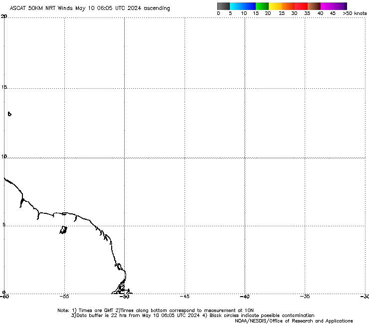
Latest Ascat. I pieced the two images together and zoomed in. I can see why the NHC said may not be closed. though ASCAT does have resolution issues with this type of system. Also appears to be two vorts according to ASCAT which also leads me to believe its closed. either way if convection builds tonight in any appreciable way they will have no choice but to make it a depression.

1 likes
Note: If I make a post that is brief. Please refer back to previous posts for the analysis or reasoning. I do not re-write/qoute what my initial post said each time.
If there is nothing before... then just ask
Space & Atmospheric Physicist, Embry-Riddle Aeronautical University,
I believe the sky is falling...
If there is nothing before... then just ask
Space & Atmospheric Physicist, Embry-Riddle Aeronautical University,
I believe the sky is falling...
-
Aric Dunn
- Category 5
- Posts: 21238
- Age: 43
- Joined: Sun Sep 19, 2004 9:58 pm
- Location: Ready for the Chase.
- Contact:
Re: ATL: INVEST 95L - Discussion
since the shear is out of the ese to SE presently that might be helping push the SAL just far enough away.
0 likes
Note: If I make a post that is brief. Please refer back to previous posts for the analysis or reasoning. I do not re-write/qoute what my initial post said each time.
If there is nothing before... then just ask
Space & Atmospheric Physicist, Embry-Riddle Aeronautical University,
I believe the sky is falling...
If there is nothing before... then just ask
Space & Atmospheric Physicist, Embry-Riddle Aeronautical University,
I believe the sky is falling...
-
Aric Dunn
- Category 5
- Posts: 21238
- Age: 43
- Joined: Sun Sep 19, 2004 9:58 pm
- Location: Ready for the Chase.
- Contact:
Re: ATL: INVEST 95L - Discussion
COnvection really starting to build now.
0 likes
Note: If I make a post that is brief. Please refer back to previous posts for the analysis or reasoning. I do not re-write/qoute what my initial post said each time.
If there is nothing before... then just ask
Space & Atmospheric Physicist, Embry-Riddle Aeronautical University,
I believe the sky is falling...
If there is nothing before... then just ask
Space & Atmospheric Physicist, Embry-Riddle Aeronautical University,
I believe the sky is falling...
-
cycloneye

- Admin

- Posts: 149379
- Age: 69
- Joined: Thu Oct 10, 2002 10:54 am
- Location: San Juan, Puerto Rico
Re: ATL: INVEST 95L - Discussion
STWO issued

Satellite imagery indicates that shower activity associated with a
small area of low pressure and a tropical wave located several
hundred miles west-southwest of the Cabo Verde Islands has become
better organized during the past few hours. Some additional
development of this system is possible, and a tropical depression
could form during the next day or two while it moves westward to
west-northwestward at 15 to 20 mph over the tropical Atlantic
Ocean. By the weekend, upper-level winds are expected to become less
conducive for development when the system approaches the Lesser
Antilles.
* Formation chance through 48 hours...medium...50 percent.
* Formation chance through 5 days...medium...50 percent.
4 likes
Visit the Caribbean-Central America Weather Thread where you can find at first post web cams,radars
and observations from Caribbean basin members Click Here
and observations from Caribbean basin members Click Here
-
Aric Dunn
- Category 5
- Posts: 21238
- Age: 43
- Joined: Sun Sep 19, 2004 9:58 pm
- Location: Ready for the Chase.
- Contact:
Re: ATL: INVEST 95L - Discussion
cycloneye wrote:STWO issuedSatellite imagery indicates that shower activity associated with a
small area of low pressure and a tropical wave located several
hundred miles west-southwest of the Cabo Verde Islands has become
better organized during the past few hours. Some additional
development of this system is possible, and a tropical depression
could form during the next day or two while it moves westward to
west-northwestward at 15 to 20 mph over the tropical Atlantic
Ocean. By the weekend, upper-level winds are expected to become less
conducive for development when the system approaches the Lesser
Antilles.
* Formation chance through 48 hours...medium...50 percent.
* Formation chance through 5 days...medium...50 percent.
Not surprised at all. the convective pattern is quite a bit improved with the recent convection beginning to rotate to the west side.
1 likes
Note: If I make a post that is brief. Please refer back to previous posts for the analysis or reasoning. I do not re-write/qoute what my initial post said each time.
If there is nothing before... then just ask
Space & Atmospheric Physicist, Embry-Riddle Aeronautical University,
I believe the sky is falling...
If there is nothing before... then just ask
Space & Atmospheric Physicist, Embry-Riddle Aeronautical University,
I believe the sky is falling...
-
Aric Dunn
- Category 5
- Posts: 21238
- Age: 43
- Joined: Sun Sep 19, 2004 9:58 pm
- Location: Ready for the Chase.
- Contact:
Re: ATL: INVEST 95L - Discussion: STWO issued=50%/50%
Though it might be the new ascat pass that pushed them to issue the special outlook.. showing a closed circulation now.
0 likes
Note: If I make a post that is brief. Please refer back to previous posts for the analysis or reasoning. I do not re-write/qoute what my initial post said each time.
If there is nothing before... then just ask
Space & Atmospheric Physicist, Embry-Riddle Aeronautical University,
I believe the sky is falling...
If there is nothing before... then just ask
Space & Atmospheric Physicist, Embry-Riddle Aeronautical University,
I believe the sky is falling...
Who is online
Users browsing this forum: No registered users and 8 guests