ATL: BERYL - Post-Tropical
Moderator: S2k Moderators
-
galaxy401

- Category 5

- Posts: 2446
- Age: 30
- Joined: Sat Aug 25, 2012 9:04 pm
- Location: Casa Grande, Arizona
Re: ATL: BERYL - Tropical Storm
Yeah, looks like an eye to me. Very tiny!
0 likes
Got my eyes on moving right into Hurricane Alley: Florida.
-
EquusStorm
- Category 5
- Posts: 1649
- Age: 35
- Joined: Thu Nov 07, 2013 1:04 pm
- Location: Jasper, AL
- Contact:
Re: ATL: BERYL - Tropical Storm
Amazing. Glad I stayed up for that; 48 or even 24 hours ago this seemed like a laughably impossible occurrence. The eye continues to get even better defined.

1 likes
Colors of lost purpose on the canvas of irrelevance
Not a meteorologist, in fact more of an idiot than anything. You should probably check with the NHC or a local NWS office for official information.
Not a meteorologist, in fact more of an idiot than anything. You should probably check with the NHC or a local NWS office for official information.
-
Aric Dunn
- Category 5
- Posts: 21238
- Age: 43
- Joined: Sun Sep 19, 2004 9:58 pm
- Location: Ready for the Chase.
- Contact:
Re: ATL: BERYL - Tropical Storm
Yeah RI is looking more likely at this point. smallest major hurricane maybe lol ?
always makes me wonder how many of these type of systems went unnoticed over the years until satellite became clear enough to resolve systems this small.
always makes me wonder how many of these type of systems went unnoticed over the years until satellite became clear enough to resolve systems this small.
1 likes
Note: If I make a post that is brief. Please refer back to previous posts for the analysis or reasoning. I do not re-write/qoute what my initial post said each time.
If there is nothing before... then just ask
Space & Atmospheric Physicist, Embry-Riddle Aeronautical University,
I believe the sky is falling...
If there is nothing before... then just ask
Space & Atmospheric Physicist, Embry-Riddle Aeronautical University,
I believe the sky is falling...

Re: ATL: BERYL - Models
Is Beryl too small for the models to resolve? Several don't even have it as a closed system on the 00z runs.
0 likes
The above post is not official and should not be used as such. It is the opinion of the poster and may or may not be backed by sound meteorological data. It is not endorsed by any professional institution or storm2k.org. For official information, please refer to the NHC and NWS products.
-
EquusStorm
- Category 5
- Posts: 1649
- Age: 35
- Joined: Thu Nov 07, 2013 1:04 pm
- Location: Jasper, AL
- Contact:
Re: ATL: BERYL - Tropical Storm
Yeah. Even in the deep tropics something this incredibly small and relatively brief would've been easily missed or at least severely underestimated without satellites I think.
0 likes
Colors of lost purpose on the canvas of irrelevance
Not a meteorologist, in fact more of an idiot than anything. You should probably check with the NHC or a local NWS office for official information.
Not a meteorologist, in fact more of an idiot than anything. You should probably check with the NHC or a local NWS office for official information.
-
Hurricane Mike
- Category 2

- Posts: 675
- Joined: Tue Apr 10, 2018 7:44 am
-
CyclonicFury

- Category 5
- Posts: 2032
- Age: 27
- Joined: Sun Jul 02, 2017 12:32 pm
- Location: NC
- Contact:
Re: ATL: BERYL - Cat1 Hurricane: 65KT
FIRST JULY ATLANTIC HURRICANE SINCE 2014
2 likes
NCSU B.S. in Meteorology Class of 2021. Tropical weather blogger at http://www.cyclonicfury.com. My forecasts and thoughts are NOT official, for official forecasts please consult the National Hurricane Center.
-
ouragans

- Category 2
- Posts: 501
- Age: 54
- Joined: Sun Jun 12, 2011 12:09 pm
- Location: Abymes, Guadeloupe F.W.I
- Contact:
Re: ATL: BERYL - Tropical Storm
AutoPenalti wrote:It’s not an eye, remember that convection appears to be shallow and thus can leave some false assumptions of an eye forming.
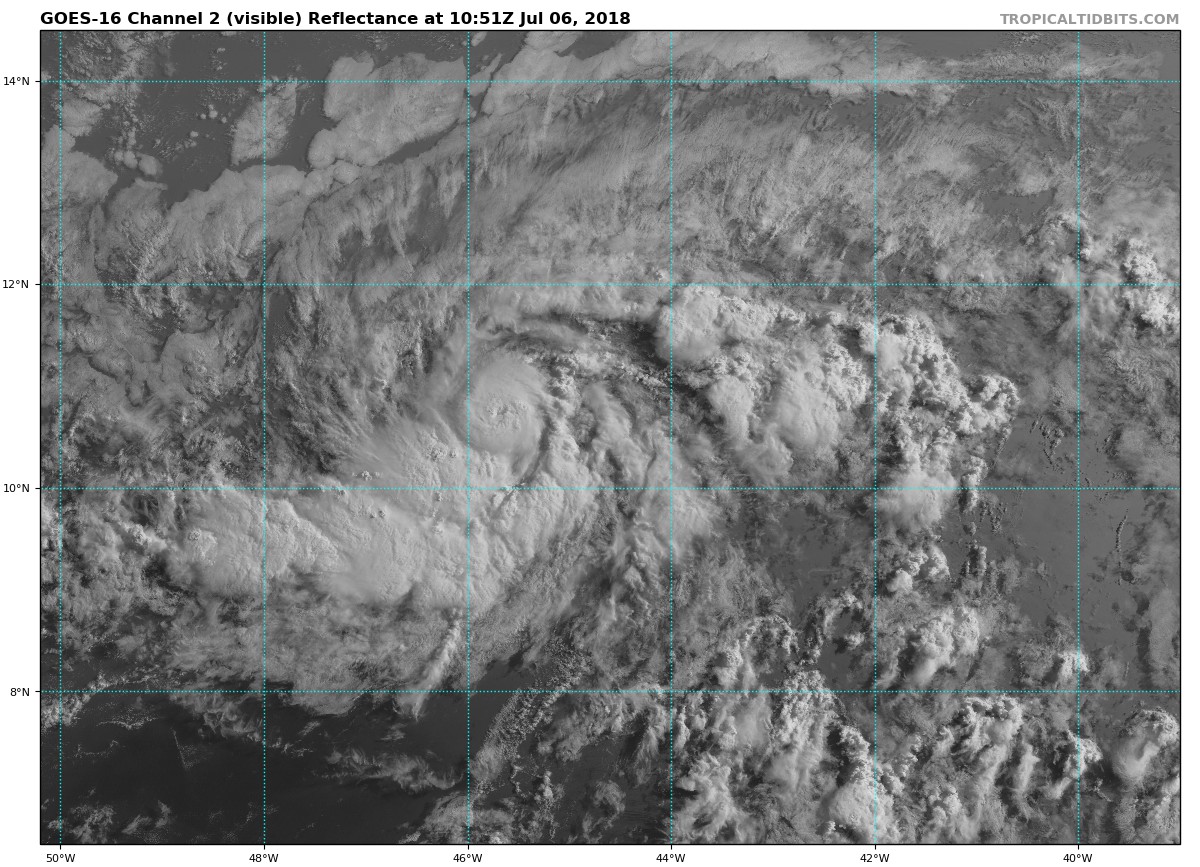
An earlier AMSR2 microwave overpass showed a well-defined mid-level eye and a pinhole eye has been apparent in the various GOES-16 satellite channels since shortly after 0600 UTC and was most evident around 0715 UTC.
It was an eye
0 likes
Personal forecast disclaimer
This post is a personal point of view, not an information. Please refer to official statements for life-threatening decisions.
David '79, Frederic '79, Hugo '89, Iris, Luis & Marilyn '95, Georges '98, Lenny '99, Dean '07, Irma '17, Maria '17, Fiona '22, Philippe '23, Tammy '23
16°13'33.3,"6N -61°36'39.5"W
-
cycloneye

- Admin

- Posts: 149372
- Age: 69
- Joined: Thu Oct 10, 2002 10:54 am
- Location: San Juan, Puerto Rico
Re: ATL: BERYL - Advisories
BULLETIN
Hurricane Beryl Advisory Number 4
NWS National Hurricane Center Miami FL AL022018
500 AM AST Fri Jul 06 2018
...TINY BERYL BECOMES THE FIRST HURRICANE OF THE 2018 ATLANTIC
HURRICANE SEASON...
SUMMARY OF 500 AM AST...0900 UTC...INFORMATION
----------------------------------------------
LOCATION...10.6N 45.1W
ABOUT 1140 MI...1830 KM ESE OF THE LESSER ANTILLES
MAXIMUM SUSTAINED WINDS...75 MPH...120 KM/H
PRESENT MOVEMENT...W OR 275 DEGREES AT 14 MPH...22 KM/H
MINIMUM CENTRAL PRESSURE...995 MB...29.39 INCHES
WATCHES AND WARNINGS
--------------------
There are no coastal watches or warnings in effect.
Interests in the Lesser Antilles should monitor the progress of
Beryl.
Hurricane Beryl Discussion Number 4
NWS National Hurricane Center Miami FL AL022018
500 AM AST Fri Jul 06 2018
Deep convection associated with the tiny tropical cyclone has
continued to become better organized overnight. An earlier AMSR2
microwave overpass showed a well-defined mid-level eye and a
pinhole eye has been apparent in the various GOES-16 satellite
channels since shortly after 0600 UTC and was most evident around
0715 UTC. Although the clarity of the eye has waxed and waned since
that time, there is enough convective organization to increase the
initial intensity to 65 kt, making Beryl the first hurricane of the
2018 Atlantic hurricane season.
The cyclone has another 18-24 hour within very low vertical wind
shear conditions and over SSTS of 26-27 degrees Celsius. These
favorable conditions suggest that the tiny hurricane is likely to
intensify further today. The NHC intensity forecast calls for
additional strengthening and is at the upper-end of the intensity
guidance, but I would not be too surprised if the compact hurricane
reaches a slightly higher peak intensity than indicated below. By
36 hours, the shear is forecast to increase to more than 15 kt, and
it is expected to be greater than 20 kt shortly after that time.
This should cause the very small tropical cyclone to quickly
weaken, however as mentioned in the Key Messages below there is
greater uncertainty than usual regarding Beryl's intensity
forecast. Although the updated NHC forecast shows Beryl
reaching the Lesser Antilles as a tropical storm it is highly
possible that the system will have degenerated into an open trough
by that time. Regardless of the system's status at 72 h, it is
likely to bring strong gusty winds and locally heavy rains to
portions of the Lesser Antilles Sunday and Monday.
The initial motion estimate remains 275/12 kt. The track guidance
is in good agreement taking Beryl west-northwestward to the
south of a deep-layer ridge over the central Atlantic. There
has been little overall change in the latest dynamical guidance and
the new NHC track forecast is similar to the previous advisory and
lies along the southern edge of the guidance envelope closest to
the latest ECMWF and HFIP correct consensus models.
Key Messages:
1. Due to its very small size, there is greater-than-usual
uncertainty in the analysis of Beryl's current intensity. Confidence
in the official intensity forecast is also much lower than normal.
Rapid changes in intensity, both up and down, that are difficult to
predict are possible during the next couple of days.
2. While Beryl is still to forecast to quickly weaken or dissipate
as a tropical cyclone on Monday before reaching the Lesser Antilles,
there will likely be some rain and wind impacts on those islands
early next week. Residents there should monitor products from their
local weather office for more information.
FORECAST POSITIONS AND MAX WINDS
INIT 06/0900Z 10.6N 45.1W 65 KT 75 MPH
12H 06/1800Z 11.0N 46.6W 75 KT 85 MPH
24H 07/0600Z 11.7N 48.6W 75 KT 85 MPH
36H 07/1800Z 12.7N 51.0W 65 KT 75 MPH
48H 08/0600Z 13.6N 54.4W 55 KT 65 MPH
72H 09/0600Z 15.4N 61.9W 45 KT 50 MPH
96H 10/0600Z...DISSIPATED
$$
Forecaster Brown
0 likes
Visit the Caribbean-Central America Weather Thread where you can find at first post web cams,radars
and observations from Caribbean basin members Click Here
and observations from Caribbean basin members Click Here
-
northjaxpro

- S2K Supporter

- Posts: 8900
- Joined: Mon Sep 27, 2010 11:21 am
- Location: Jacksonville, FL
Re: ATL: BERYL - Models
The new 06Z GFS run shows.the remnants of Beryl reaching South Florida in 168 hours.
0 likes
NEVER, EVER SAY NEVER in the tropics and weather in general, and most importantly, with life itself!!
________________________________________________________________________________________
Fay 2008 Beryl 2012 Debby 2012 Colin 2016 Hermine 2016 Julia 2016 Matthew 2016 Irma 2017 Dorian 2019
________________________________________________________________________________________
Fay 2008 Beryl 2012 Debby 2012 Colin 2016 Hermine 2016 Julia 2016 Matthew 2016 Irma 2017 Dorian 2019
-
cycloneye
- Admin
- Posts: 149372
- Age: 69
- Joined: Thu Oct 10, 2002 10:54 am
- Location: San Juan, Puerto Rico
Re: ATL: BERYL - Hurricane
@EricBlake12
Just can’t get over this tiny #Hurricane #Beryl - should be sleeping but look at it go! Can’t imagine we have seen a hurricane so far south and east in July before. Hoping the forecast shear gets it before the Islands.
https://twitter.com/EricBlake12/status/1015163798687305728
Just can’t get over this tiny #Hurricane #Beryl - should be sleeping but look at it go! Can’t imagine we have seen a hurricane so far south and east in July before. Hoping the forecast shear gets it before the Islands.
https://twitter.com/EricBlake12/status/1015163798687305728
0 likes
Visit the Caribbean-Central America Weather Thread where you can find at first post web cams,radars
and observations from Caribbean basin members Click Here
and observations from Caribbean basin members Click Here
-
TheStormExpert
Re: ATL: BERYL - Hurricane
I’m surely going to be eating a lot of crow after assuming we’d never see a hurricane in the Tropical Atlantic at all this season. First July Tropical Atlantic hurricane since Bertha in 2008.
1 likes
-
cycloneye
- Admin
- Posts: 149372
- Age: 69
- Joined: Thu Oct 10, 2002 10:54 am
- Location: San Juan, Puerto Rico
Re: ATL: BERYL - Hurricane

0 likes
Visit the Caribbean-Central America Weather Thread where you can find at first post web cams,radars
and observations from Caribbean basin members Click Here
and observations from Caribbean basin members Click Here
-
northjaxpro
- S2K Supporter
- Posts: 8900
- Joined: Mon Sep 27, 2010 11:21 am
- Location: Jacksonville, FL
Re: ATL: BERYL - Hurricane
Dry air and shear should eventually get Beryl as she approaches the islands, but these tiny cyclones can be tricky to forecast, especially intensity, as we saw with Danny in 2015.
Beryl looks impressive early this morning, nevertheless, for now. She has an Impressive eye feature. Beryl may be intensifying short term.
Beryl looks impressive early this morning, nevertheless, for now. She has an Impressive eye feature. Beryl may be intensifying short term.
Last edited by northjaxpro on Fri Jul 06, 2018 6:15 am, edited 1 time in total.
0 likes
NEVER, EVER SAY NEVER in the tropics and weather in general, and most importantly, with life itself!!
________________________________________________________________________________________
Fay 2008 Beryl 2012 Debby 2012 Colin 2016 Hermine 2016 Julia 2016 Matthew 2016 Irma 2017 Dorian 2019
________________________________________________________________________________________
Fay 2008 Beryl 2012 Debby 2012 Colin 2016 Hermine 2016 Julia 2016 Matthew 2016 Irma 2017 Dorian 2019


Re: ATL: BERYL - Hurricane
Indeed Beryl has pulled off what Danny did in 2015. Tenacious cluster with good structure that kept re-firing convection. The little engine that could to become a micro-cane.
1 likes
The above post and any post by Ntxw is NOT an official forecast and should not be used as such. It is just the opinion of the poster and may or may not be backed by sound meteorological data. It is NOT endorsed by any professional institution including Storm2k. For official information, please refer to NWS products.
Help support Storm2K!


Re: ATL: BERYL - Hurricane
I can see small eyewall towers firing on IR.
Vis showing the cirrus remmants of the towers stacking on top of the canopy.
Almost need a microscope to see this.
Amazing how this mechanism holds even on such a small scale.
Vis showing the cirrus remmants of the towers stacking on top of the canopy.
Almost need a microscope to see this.
Amazing how this mechanism holds even on such a small scale.
0 likes

Re: ATL: BERYL - Hurricane
06Z HWRF still showing Beryl disintegrating from dry air/shear before Guadeloupe.
Visible frames this morning are self evident and successfully forecast..
Visible frames this morning are self evident and successfully forecast..
Last edited by Nimbus on Fri Jul 06, 2018 6:37 am, edited 1 time in total.
0 likes

Re: ATL: BERYL - Models
00z CMC redevelops Beryl north of cuba and brings the system up along the west coast of Florida next Thursday.
https://www.tropicaltidbits.com/analysis/models/?model=gem®ion=us&pkg=mslp_pcpn_frzn&runtime=2018070600&fh=12
https://www.tropicaltidbits.com/analysis/models/?model=gem®ion=us&pkg=mslp_pcpn_frzn&runtime=2018070600&fh=12
0 likes

Who is online
Users browsing this forum: No registered users and 9 guests