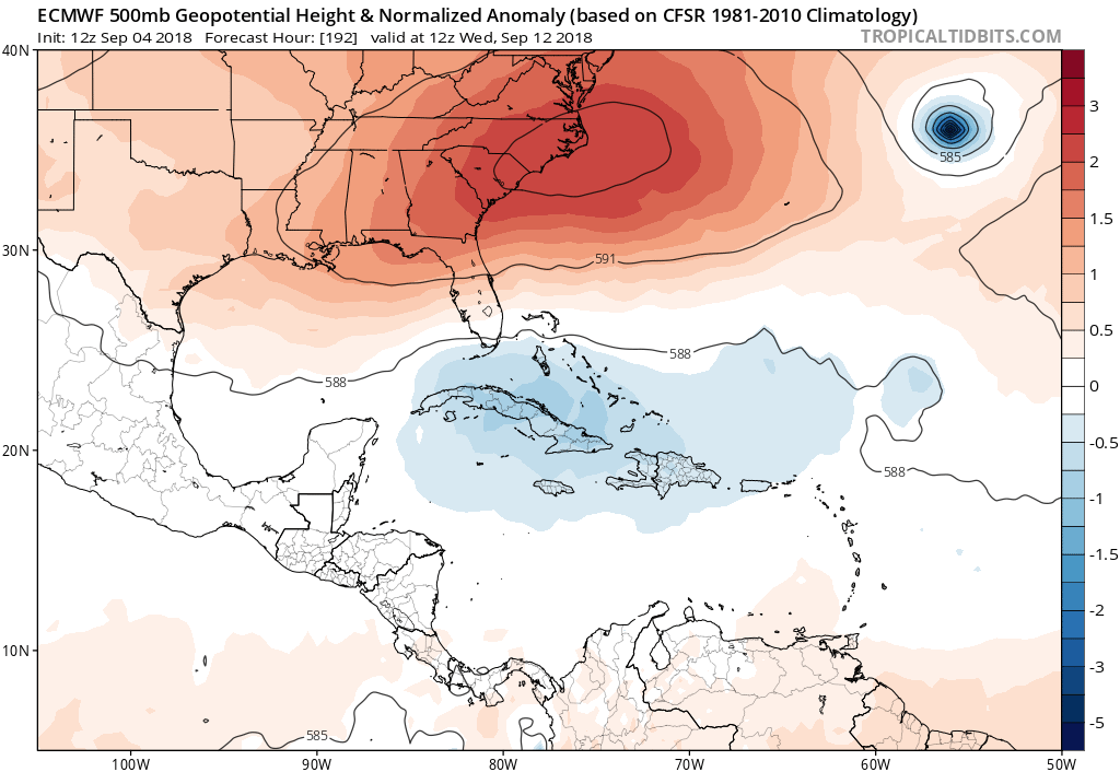
2018 Tropics: Global Model Runs Discussion (Out to day 16)

This is the general tropical discussion area. Anyone can take their shot at predicting a storms path.

Moderator: S2k Moderators

Forum rules

The posts in this forum are NOT official forecasts and should not be used as such. They are just the opinion of the poster and may or may not be backed by sound meteorological data. They are NOT endorsed by any professional institution or STORM2K. For official information, please refer to products from the National Hurricane Center and National Weather Service.

Help Support Storm2K
Message
Author
User avatar
mcheer23
Professional-Met
Professional-Met
Posts: 436
Age: 32
Joined: Sun Jun 24, 2012 8:24 pm
Location: Sugar Land, Texas

Re: 2018 Tropics: Global Model Runs Discussion (Out to day 16)

#1721 Postby mcheer23 » Tue Sep 04, 2018 8:28 pm

Kazmit wrote:
otowntiger wrote:
toad strangler wrote:Looks like a conga line of re curves :lol:

Lol, yep- I called it ‘tropical fish train’! Sure as someone said, the high could build back in but with that steady succession of systems rolling in I think each system will be keeping the door open for the next guy to go thru.

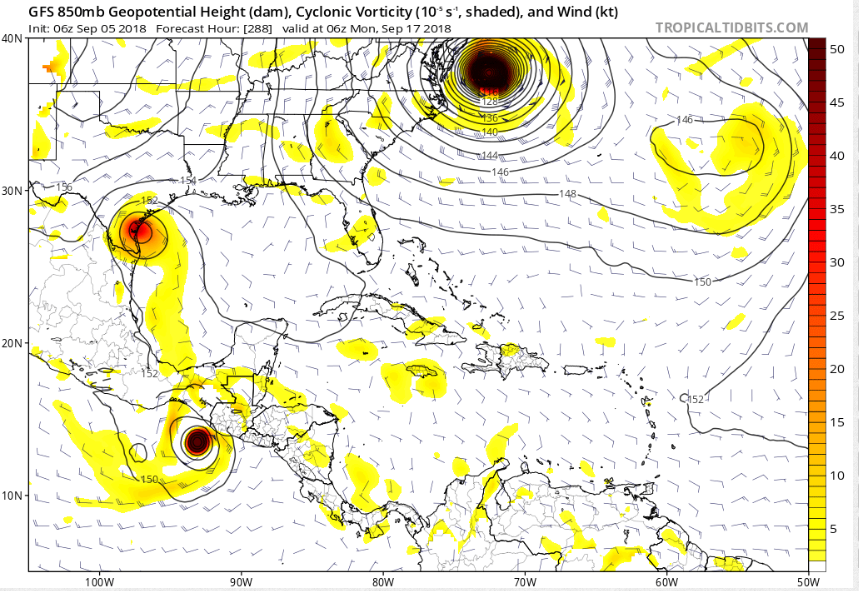
That sounds good to me. Plenty of storms to track, good surf, and no threat to land.


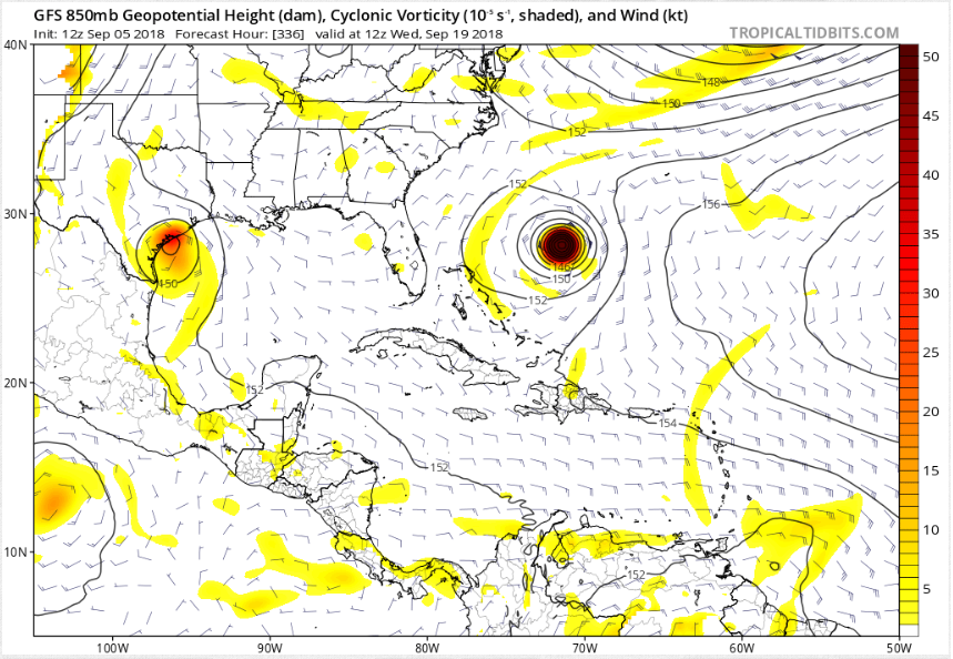
Might have at least one storm in the SW GOM or BOC that's one to track for Mexico or Texas
1 likes   

User avatar
northjaxpro
S2K Supporter
S2K Supporter
Posts: 8900
Joined: Mon Sep 27, 2010 11:21 am
Location: Jacksonville, FL

Re: 2018 Tropics: Global Model Runs Discussion (Out to day 16)

#1722 Postby northjaxpro » Tue Sep 04, 2018 8:48 pm

blp wrote:
gatorcane wrote:If that many storms do happen per the Euro, you got to think one might slip through. The weakness created by Florence won’t be there the entire time. The ridge over the Eastern US looks very dominant. Usually we see troughs swinging through instead.

Euro heights 192 hours:

Image


I agree. I don't remember seeing that strong a ridge so firmly entrenched over the east coast in a long time and every major model is showing this so this is not some Euro fantasy. 60w looks like the point after which anything will get trapped.


Positive NAO is forecast well into September. Anomolous HP is likely to happen over the Western Atlantic or the U.S. Atlantic seaboard. This set-up or pattern indeed is quite worrisome for potential tropical cyclone strikes , especially the U.S.East Coast or even Gulf of Mexico region.. All dependent on the strength of the Bermuda High.
0 likes   
NEVER, EVER SAY NEVER in the tropics and weather in general, and most importantly, with life itself!!

________________________________________________________________________________________

Fay 2008 Beryl 2012 Debby 2012 Colin 2016 Hermine 2016 Julia 2016 Matthew 2016 Irma 2017 Dorian 2019

User avatar
La Breeze
Tropical Storm
Tropical Storm
Posts: 168
Joined: Sun Jul 26, 2015 3:21 am
Location: Vermilion Parish, LA

Re: 2018 Tropics: Global Model Runs Discussion (Out to day 16)

#1723 Postby La Breeze » Tue Sep 04, 2018 11:04 pm

wxGuy wrote:+264
Image

Anyone have more info or model readings on this? Just wondering.
1 likes   
Not a professional forecast by any means.
Audrey'57, Hilda'64, Betsy '65, Edith'71, Carmen'74, Danny'85, Juan'85, Andrew'92, Iniki'92 (while on vacation in Kauai), Lili'02, Rita'05, Humberto'07, Gustav'08, Ike'08, Isaac'12, Monsoonal Depression'16, Harvey'17, Barry'19, Laura'20, Delta'20, Ida'21.

User avatar
Cpv17
Category 5
Category 5
Posts: 4979
Joined: Wed Dec 07, 2016 2:24 pm
Location: Wharton/El Campo, TX

Re: 2018 Tropics: Global Model Runs Discussion (Out to day 16)

#1724 Postby Cpv17 » Tue Sep 04, 2018 11:12 pm

La Breeze wrote:
wxGuy wrote:+264
Image

Anyone have more info or model readings on this? Just wondering.


This is something where we have plenty of time to watch. The CMC and GFS model have been hinting at development in the BOC in about 10 days or so, but the majority of the runs have had minimal development and it gets buried into Mexico. Only two runs of the GFS so far have had this going into Texas. I doubt anything comes out of it at this time, but you never know.
1 likes   

User avatar
La Breeze
Tropical Storm
Tropical Storm
Posts: 168
Joined: Sun Jul 26, 2015 3:21 am
Location: Vermilion Parish, LA

Re: 2018 Tropics: Global Model Runs Discussion (Out to day 16)

#1725 Postby La Breeze » Wed Sep 05, 2018 1:38 am

Cpv17 wrote:
La Breeze wrote:
wxGuy wrote:+264
Image

Anyone have more info or model readings on this? Just wondering.


This is something where we have plenty of time to watch. The CMC and GFS model have been hinting at development in the BOC in about 10 days or so, but the majority of the runs have had minimal development and it gets buried into Mexico. Only two runs of the GFS so far have had this going into Texas. I doubt anything comes out of it at this time, but you never know.

Thanks Cpv17.
0 likes   
Not a professional forecast by any means.
Audrey'57, Hilda'64, Betsy '65, Edith'71, Carmen'74, Danny'85, Juan'85, Andrew'92, Iniki'92 (while on vacation in Kauai), Lili'02, Rita'05, Humberto'07, Gustav'08, Ike'08, Isaac'12, Monsoonal Depression'16, Harvey'17, Barry'19, Laura'20, Delta'20, Ida'21.

User avatar
SoupBone
Category 5
Category 5
Posts: 3111
Joined: Tue Sep 20, 2005 5:24 pm

Re: 2018 Tropics: Global Model Runs Discussion (Out to day 16)

#1726 Postby SoupBone » Wed Sep 05, 2018 9:35 am

The Texas coast system continues to be pushed back. It keeps pushing it back every run, and it's now 3 days behind what it was previously showing on the GFS. I think the GFS is in la la land right now, but at least it gives us something to talk about.

Image
1 likes   
Personal Forecast Disclaimer:
The posts in this forum are NOT official forecast and should not be used as such. They are just the opinion of the poster and may or may not be backed by sound meteorological data. They are NOT endorsed by any professional institution or storm2k.org. For official information, please refer to the NHC and NWS products.

wxGuy

Re: 2018 Tropics: Global Model Runs Discussion (Out to day 16)

#1727 Postby wxGuy » Wed Sep 05, 2018 10:02 am

La Breeze wrote:
Cpv17 wrote:
La Breeze wrote:Anyone have more info or model readings on this? Just wondering.


This is something where we have plenty of time to watch. The CMC and GFS model have been hinting at development in the BOC in about 10 days or so, but the majority of the runs have had minimal development and it gets buried into Mexico. Only two runs of the GFS so far have had this going into Texas. I doubt anything comes out of it at this time, but you never know.

Thanks Cpv17.


checked gfs today and its back
0 likes   

SconnieCane
Category 4
Category 4
Posts: 998
Joined: Thu Aug 02, 2018 5:29 pm
Location: Madison, WI

Re: 2018 Tropics: Global Model Runs Discussion (Out to day 16)

#1728 Postby SconnieCane » Wed Sep 05, 2018 10:35 am

This whole process of model watching as the Atlantic woke up from its August slumber, from watching the waves roll across Africa and seeing "modelstorms" pop up in the far long range, to them appearing on the 5-day TWO, then becoming invests, and evolving into storms like Florence, reminds me of the battle scene from Star Wars:

"Stabilize your rear deflectors. Watch for enemy fighters...They're coming in! Three marks at two-ten!"
5 likes   

User avatar
mcheer23
Professional-Met
Professional-Met
Posts: 436
Age: 32
Joined: Sun Jun 24, 2012 8:24 pm
Location: Sugar Land, Texas

Re: 2018 Tropics: Global Model Runs Discussion (Out to day 16)

#1729 Postby mcheer23 » Wed Sep 05, 2018 11:59 am

wxGuy wrote:
La Breeze wrote:
Cpv17 wrote:
This is something where we have plenty of time to watch. The CMC and GFS model have been hinting at development in the BOC in about 10 days or so, but the majority of the runs have had minimal development and it gets buried into Mexico. Only two runs of the GFS so far have had this going into Texas. I doubt anything comes out of it at this time, but you never know.

Thanks Cpv17.


checked gfs today and its back


Another run, another TX landfall...however weaker.
1 likes   

User avatar
SoupBone
Category 5
Category 5
Posts: 3111
Joined: Tue Sep 20, 2005 5:24 pm

Re: 2018 Tropics: Global Model Runs Discussion (Out to day 16)

#1730 Postby SoupBone » Wed Sep 05, 2018 12:17 pm

mcheer23 wrote:
wxGuy wrote:
La Breeze wrote:Thanks Cpv17.


checked gfs today and its back


Another run, another TX landfall...however weaker.


Yeah but like I posted earlier, it keeps getting pushed back. It's now 6 days beyond the original hint at a Texas system (it was originally showing the 13th). The GFS (if I recall) has been known to spin these phantoms up, and continue to push development back by days. It's a strange thing. Guess we'll keep looking at it though. :lol:

Image
0 likes   
Personal Forecast Disclaimer:
The posts in this forum are NOT official forecast and should not be used as such. They are just the opinion of the poster and may or may not be backed by sound meteorological data. They are NOT endorsed by any professional institution or storm2k.org. For official information, please refer to the NHC and NWS products.

User avatar
NDG
S2K Supporter
S2K Supporter
Posts: 15446
Joined: Sun Jul 09, 2006 10:14 pm
Location: Orlando, FL

Re: 2018 Tropics: Global Model Runs Discussion (Out to day 16)

#1731 Postby NDG » Wed Sep 05, 2018 12:23 pm

SoupBone wrote:
mcheer23 wrote:
wxGuy wrote:
checked gfs today and its back


Another run, another TX landfall...however weaker.


Yeah but like I posted earlier, it keeps getting pushed back. It's now 6 days beyond the original hint at a Texas system (it was originally showing the 13th). The GFS (if I recall) has been known to spin these phantoms up, and continue to push development back by days. It's a strange thing. Guess we'll keep looking at it though. :lol:

https://s22.postimg.cc/5fw0q5i3l/wave.png


Actually the GFS has not been that aggressive lately on spinning up phantom storms.
1 likes   

User avatar
SoupBone
Category 5
Category 5
Posts: 3111
Joined: Tue Sep 20, 2005 5:24 pm

Re: 2018 Tropics: Global Model Runs Discussion (Out to day 16)

#1732 Postby SoupBone » Wed Sep 05, 2018 1:20 pm

NDG wrote:
SoupBone wrote:
mcheer23 wrote:

Another run, another TX landfall...however weaker.


Yeah but like I posted earlier, it keeps getting pushed back. It's now 6 days beyond the original hint at a Texas system (it was originally showing the 13th). The GFS (if I recall) has been known to spin these phantoms up, and continue to push development back by days. It's a strange thing. Guess we'll keep looking at it though. :lol:

https://s22.postimg.cc/5fw0q5i3l/wave.png


Actually the GFS has not been that aggressive lately on spinning up phantom storms.


Well again though, each consecutive run keeps pushing the date back. It started as a September 13th landfall, and now it's on the 19th. Something isn't quite right with that. But again, it does make a nice conversation topic. :D
0 likes   
Personal Forecast Disclaimer:
The posts in this forum are NOT official forecast and should not be used as such. They are just the opinion of the poster and may or may not be backed by sound meteorological data. They are NOT endorsed by any professional institution or storm2k.org. For official information, please refer to the NHC and NWS products.

User avatar
Cpv17
Category 5
Category 5
Posts: 4979
Joined: Wed Dec 07, 2016 2:24 pm
Location: Wharton/El Campo, TX

Re: 2018 Tropics: Global Model Runs Discussion (Out to day 16)

#1733 Postby Cpv17 » Wed Sep 05, 2018 2:07 pm

SoupBone wrote:
NDG wrote:
SoupBone wrote:
Yeah but like I posted earlier, it keeps getting pushed back. It's now 6 days beyond the original hint at a Texas system (it was originally showing the 13th). The GFS (if I recall) has been known to spin these phantoms up, and continue to push development back by days. It's a strange thing. Guess we'll keep looking at it though. :lol:

https://s22.postimg.cc/5fw0q5i3l/wave.png


Actually the GFS has not been that aggressive lately on spinning up phantom storms.


Well again though, each consecutive run keeps pushing the date back. It started as a September 13th landfall, and now it's on the 19th. Something isn't quite right with that. But again, it does make a nice conversation topic. :D


Genesis has started around the same time, but the landfall keeps getting pushed back. Looks like it just sits in the BOC for a good while.
0 likes   

User avatar
mcheer23
Professional-Met
Professional-Met
Posts: 436
Age: 32
Joined: Sun Jun 24, 2012 8:24 pm
Location: Sugar Land, Texas

Re: 2018 Tropics: Global Model Runs Discussion (Out to day 16)

#1734 Postby mcheer23 » Wed Sep 05, 2018 3:04 pm

The area in the BOC/ SW GOM is now featured on the Global Tropical Hazards outlook
http://www.cpc.ncep.noaa.gov/products/p ... /ghazards/

Euro started to pick up on it today also.
3 likes   

User avatar
SoupBone
Category 5
Category 5
Posts: 3111
Joined: Tue Sep 20, 2005 5:24 pm

Re: 2018 Tropics: Global Model Runs Discussion (Out to day 16)

#1735 Postby SoupBone » Wed Sep 05, 2018 3:15 pm

mcheer23 wrote:The area in the BOC/ SW GOM is now featured on the Global Tropical Hazards outlook
http://www.cpc.ncep.noaa.gov/products/p ... /ghazards/

Euro started to pick up on it today also.


"The GFS and some ensemble members from the European model suggest that tropical cyclone development is possible over the western Gulf of Mexico during Week-2, which has been indicated in our forecast."

So they're basing is strictly from model runs?
0 likes   
Personal Forecast Disclaimer:
The posts in this forum are NOT official forecast and should not be used as such. They are just the opinion of the poster and may or may not be backed by sound meteorological data. They are NOT endorsed by any professional institution or storm2k.org. For official information, please refer to the NHC and NWS products.

stormlover2013

Re: 2018 Tropics: Global Model Runs Discussion (Out to day 16)

#1736 Postby stormlover2013 » Wed Sep 05, 2018 3:18 pm

yep that's what they do when its sept and peak of season.
0 likes   

storminabox
Category 1
Category 1
Posts: 263
Joined: Sun Jul 09, 2017 10:50 pm

Re: 2018 Tropics: Global Model Runs Discussion (Out to day 16)

#1737 Postby storminabox » Wed Sep 05, 2018 5:07 pm

SconnieCane wrote:This whole process of model watching as the Atlantic woke up from its August slumber, from watching the waves roll across Africa and seeing "modelstorms" pop up in the far long range, to them appearing on the 5-day TWO, then becoming invests, and evolving into storms like Florence, reminds me of the battle scene from Star Wars:

"Stabilize your rear deflectors. Watch for enemy fighters...They're coming in! Three marks at two-ten!"


The evolution of how the Atlantic just goes from being dead to very active never ceases to amaze me. I remember a few weeks ago when the models first started to show hints to the very active period we are in now. It’s amazing how the flip just switches every year without fail once we start getting to this time of year.
2 likes   

User avatar
mcheer23
Professional-Met
Professional-Met
Posts: 436
Age: 32
Joined: Sun Jun 24, 2012 8:24 pm
Location: Sugar Land, Texas

Re: 2018 Tropics: Global Model Runs Discussion (Out to day 16)

#1738 Postby mcheer23 » Wed Sep 05, 2018 6:49 pm

18z GFS still shows this system...however sends it straight to Mexico. Barley has any time in the BOC
0 likes   

User avatar
NDG
S2K Supporter
S2K Supporter
Posts: 15446
Joined: Sun Jul 09, 2006 10:14 pm
Location: Orlando, FL

Re: 2018 Tropics: Global Model Runs Discussion (Out to day 16)

#1739 Postby NDG » Wed Sep 05, 2018 7:41 pm

SoupBone wrote:
mcheer23 wrote:The area in the BOC/ SW GOM is now featured on the Global Tropical Hazards outlook
http://www.cpc.ncep.noaa.gov/products/p ... /ghazards/

Euro started to pick up on it today also.


"The GFS and some ensemble members from the European model suggest that tropical cyclone development is possible over the western Gulf of Mexico during Week-2, which has been indicated in our forecast."

So they're basing is strictly from model runs?


That should not be a surprise to you, forecasters do that all the time based off models.
1 likes   

User avatar
SoupBone
Category 5
Category 5
Posts: 3111
Joined: Tue Sep 20, 2005 5:24 pm

Re: 2018 Tropics: Global Model Runs Discussion (Out to day 16)

#1740 Postby SoupBone » Wed Sep 05, 2018 9:36 pm

NDG wrote:
SoupBone wrote:
mcheer23 wrote:The area in the BOC/ SW GOM is now featured on the Global Tropical Hazards outlook
http://www.cpc.ncep.noaa.gov/products/p ... /ghazards/

Euro started to pick up on it today also.


"The GFS and some ensemble members from the European model suggest that tropical cyclone development is possible over the western Gulf of Mexico during Week-2, which has been indicated in our forecast."

So they're basing is strictly from model runs?


That should not be a surprise to you, forecasters do that all the time based off models.


It's not. Maybe I should rephrase the question. Are there other factors besides the GFS and a few ensembles used to add this as a moderate threat on the chart?
0 likes   
Personal Forecast Disclaimer:
The posts in this forum are NOT official forecast and should not be used as such. They are just the opinion of the poster and may or may not be backed by sound meteorological data. They are NOT endorsed by any professional institution or storm2k.org. For official information, please refer to the NHC and NWS products.


Return to “Talkin' Tropics”

Who is online

Users browsing this forum: cycloneye, Google Adsense [Bot], HurricaneAndre2008, johngaltfla, kevin, zzzh and 46 guests