ATL: FLORENCE - Models
Moderator: S2k Moderators
-
GeneratorPower

- S2K Supporter

- Posts: 1648
- Age: 46
- Joined: Sun Dec 18, 2005 11:48 pm
- Location: Huntsville, AL
Re: ATL: FLORENCE - Models
Slow moving hurricanes are among the worst possible disasters. This could be bad.
0 likes

Re: ATL: FLORENCE - Models
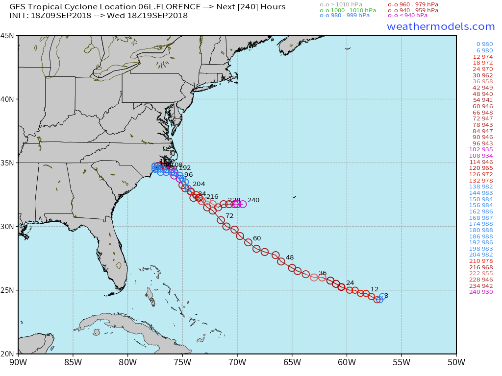
The Euro shows even stronger ridging over the NE US right before landfall than the latest GFS shows.


0 likes
-
AtlanticWind

- S2K Supporter
- Posts: 1898
- Age: 67
- Joined: Sun Aug 08, 2004 9:57 pm
- Location: Plantation,Fla
-
supercane4867
- Category 5

- Posts: 4966
- Joined: Wed Nov 14, 2012 10:43 am
Re: ATL: FLORENCE - Models
BobHarlem wrote:18Z GFS goes back and hits Bermuda?
After it hits Bermuda it makes landfall on Newfoundland as a 940mb cyclone
Then it explodes into a 935mb extrapical storm heading for Iceland...
5 likes


-
supercane4867
- Category 5
- Posts: 4966
- Joined: Wed Nov 14, 2012 10:43 am
-
meriland29

- Category 2

- Posts: 770
- Joined: Thu Aug 03, 2017 11:05 am

-
meriland29
- Category 2
- Posts: 770
- Joined: Thu Aug 03, 2017 11:05 am
Re: ATL: FLORENCE - Models
Ken711 wrote:meriland29 wrote:Does anyone have a forecasted intensity graph?
Interesting. I noticed a few maybe a few runs ago were well into the CT 5 range.
0 likes
-
plasticup
Re: ATL: FLORENCE - Models
Ken711 wrote:meriland29 wrote:Does anyone have a forecasted intensity graph?
[img ]https://www.tropicaltidbits.com/storminfo/06L_intensity_latest.png[/img]
Well that's terrifying. I don't think I've ever seen a graph like it.
0 likes
-
jlauderdal
- S2K Supporter
- Posts: 7240
- Joined: Wed May 19, 2004 5:46 am
- Location: NE Fort Lauderdale
- Contact:
Re: RE: Re: ATL: FLORENCE - Models
Why would the gfs do that when it can bust through a ridgeAric Dunn wrote:Maybe its the start of (logical ) shift back west for the models.lol
5 likes
-
supercane4867
- Category 5
- Posts: 4966
- Joined: Wed Nov 14, 2012 10:43 am

-
AubreyStorm

- Category 1

- Posts: 337
- Age: 45
- Joined: Fri Jun 16, 2017 6:21 pm
- Location: Texas, USA
Re: ATL: FLORENCE - Models
supercane4867 wrote:18z HWRF back to CAT5
18z HWRF with Isaac????
Thanks!
0 likes
The posts are NOT an official forecast. Please REFER to the NHC and NWS for official forecasts and products.
-
meriland29
- Category 2
- Posts: 770
- Joined: Thu Aug 03, 2017 11:05 am
Re: ATL: FLORENCE - Models
Basically any GFS models that stick offshore or barely over the OBX should not be considered as highly. There are too many variables that signify, heavily-- that this will be west of OBX if not south as well. 18z regular GFS is the first run in quite a few runs that was not an outlier. The biggest question mark now IMO is if it will stall due to 'ridge fight' for days or if it will just move inland with minimal or non-existent stalling. Although both are horrible, especially if she is as strong as most models predict, the 1st outcome is catastrophically worse than the 2nd. The amount of rain predicted (especially over that area which is already water-logged) would be as bad, if not worse than Harvey last year.
0 likes
-
Hurricane Mac

- Tropical Low

- Posts: 15
- Age: 40
- Joined: Sat Aug 18, 2007 7:33 pm
- Location: Sumter, SC
- Contact:
Re: ATL: FLORENCE - Models
My understanding is that has to do partially with model runs, but also the time it takes for the NHC to prepare advisories. The times of advisories are 3, 9, 15, and 21z. The reason a 11pm (EDT) advisory comes out at 10:40 or so is because they have it completed prior to the posted time (also for news to prep for the top of the hour). It is also why the position may be slightly off based on what you see on the satellite markers, as it may be 15-60 minutes old by time the package is released.
(This info is based on my experience as a met major at Univ of Miami almost 15 years ago, so take it with a grain of salt).
(This info is based on my experience as a met major at Univ of Miami almost 15 years ago, so take it with a grain of salt).
3 likes
I am no meteorologist, but I did study it at the University of Miami for 3 years before changing majors, so take everything with a ton of salt and believe just about nothing that I say. Check with the NHC and the pros for official predictions.
-
Hybridstorm_November2001

- S2K Supporter
- Posts: 2817
- Joined: Sat Aug 21, 2004 2:50 pm
- Location: SW New Brunswick, Canada
- Contact:
Re: ATL: FLORENCE - Models
Interesting, although in a heartbreaking way, how another entrenched ridge could turn a standard bad hurricane into a disaster of biblical proportions (same as with Harvey last year). It makes a person think how important highs are to synoptic scale weather.
0 likes
-
Aric Dunn
- Category 5
- Posts: 21238
- Age: 43
- Joined: Sun Sep 19, 2004 9:58 pm
- Location: Ready for the Chase.
- Contact:
Re: ATL: FLORENCE - Models
Hybridstorm_November2001 wrote:Interesting, although in a heartbreaking way, how another entrenched ridge could turn a standard bad hurricane into a disaster of biblical proportions (same as with Harvey last year). It makes a person think how important highs are to synoptic scale weather.
especially with zero troughs.. just bouncing around ridges.
2 likes
Note: If I make a post that is brief. Please refer back to previous posts for the analysis or reasoning. I do not re-write/qoute what my initial post said each time.
If there is nothing before... then just ask
Space & Atmospheric Physicist, Embry-Riddle Aeronautical University,
I believe the sky is falling...
If there is nothing before... then just ask
Space & Atmospheric Physicist, Embry-Riddle Aeronautical University,
I believe the sky is falling...

Re: ATL: FLORENCE - Models
Aric Dunn wrote:Hybridstorm_November2001 wrote:Interesting, although in a heartbreaking way, how another entrenched ridge could turn a standard bad hurricane into a disaster of biblical proportions (same as with Harvey last year). It makes a person think how important highs are to synoptic scale weather.
especially with zero troughs.. just bouncing around ridges.
Yeah this system could go in and then out and then in and then out, up and down, you never know. Need to find something to steer this system before it just sits there and washes away miles of shoreline.
0 likes
Personal Forecast Disclaimer:
The posts in this forum are NOT official forecast and should not be used as such. They are just the opinion of the poster and may or may not be backed by sound meteorological data. They are NOT endorsed by any professional institution or storm2k.org. For official information, please refer to the NHC and NWS products.
The posts in this forum are NOT official forecast and should not be used as such. They are just the opinion of the poster and may or may not be backed by sound meteorological data. They are NOT endorsed by any professional institution or storm2k.org. For official information, please refer to the NHC and NWS products.
-
toad strangler

- S2K Supporter
- Posts: 4546
- Joined: Sun Jul 28, 2013 3:09 pm
- Location: Earth
- Contact:
Re: ATL: FLORENCE - Models
Aric Dunn wrote:Hybridstorm_November2001 wrote:Interesting, although in a heartbreaking way, how another entrenched ridge could turn a standard bad hurricane into a disaster of biblical proportions (same as with Harvey last year). It makes a person think how important highs are to synoptic scale weather.
especially with zero troughs.. just bouncing around ridges.
The zero trough part is what blows my mind.
2 likes
My Weather Station
https://www.wunderground.com/dashboard/pws/KFLPORTS603
https://www.wunderground.com/dashboard/pws/KFLPORTS603
Who is online
Users browsing this forum: No registered users and 35 guests