ATL: FLORENCE - Models
Moderator: S2k Moderators
-
EquusStorm
- Category 5

- Posts: 1649
- Age: 35
- Joined: Thu Nov 07, 2013 1:04 pm
- Location: Jasper, AL
- Contact:
Re: ATL: FLORENCE - Models
Guess it's a good thing that South Carolina has taken evacuations for this pretty seriously given trends
1 likes
Colors of lost purpose on the canvas of irrelevance
Not a meteorologist, in fact more of an idiot than anything. You should probably check with the NHC or a local NWS office for official information.
Not a meteorologist, in fact more of an idiot than anything. You should probably check with the NHC or a local NWS office for official information.


Re: ATL: FLORENCE - Models
DESTRUCTION5 wrote:12z Euro 120 hrs in Savannah GA....Didnt see that coming.
Apologies for the off-topic response...but you've gotta be kidding me.
what's the Euro picking up on?
1 likes
-
SouthFLTropics

- Category 5
- Posts: 4258
- Age: 50
- Joined: Thu Aug 14, 2003 8:04 am
- Location: Port St. Lucie, Florida
Re: ATL: FLORENCE - Models
Stop the presses...I can't imagine anyone saw this coming. This potentially changes everything and just goes to show that when a system falls into a weak steering environment that it can lead to major ramifications and uncertainties in the track. I can't recall what time the Euro ensembles come out...Anyone have anything on those yet?
3 likes
Fourth Generation Florida Native
Personal Storm History: David 79, Andrew 92, Erin 95, Floyd 99, Irene 99, Frances 04, Jeanne 04, Wilma 05, Matthew 16, Irma 17, Ian 22, Nicole 22, Milton 24
Personal Storm History: David 79, Andrew 92, Erin 95, Floyd 99, Irene 99, Frances 04, Jeanne 04, Wilma 05, Matthew 16, Irma 17, Ian 22, Nicole 22, Milton 24
-
mcheer23

- Professional-Met

- Posts: 441
- Age: 32
- Joined: Sun Jun 24, 2012 8:24 pm
- Location: Sugar Land, Texas
Re: ATL: FLORENCE - Models
SouthFLTropics wrote:Stop the presses...I can't imagine anyone saw this coming. This potentially changes everything and just goes to show that when a system falls into a weak steering environment that it can lead to major ramifications and uncertainties in the track. I can't recall what time the Euro ensembles come out...Anyone have anything on those yet?
About an hour til those come out
1 likes
-
bamajammer4eva
- Category 4

- Posts: 907
- Joined: Sun Apr 18, 2010 3:21 am
- Location: Ozark, AL
Re: ATL: FLORENCE - Models
How does the Euro also show what will become 96L travel south THROUGH Helene then come out the other side and turn west? It may be a fluke run all around.
Sent from my SM-G965U using Tapatalk
Sent from my SM-G965U using Tapatalk
1 likes

Re: ATL: FLORENCE - Models
FLeastcoast wrote:artist wrote:HurricaneBelle wrote:
We don't know if there's no landfall, the images are 24 hours apart.
Actually, it is run twice a day, so 12 hours, but your point is well taken.
I am in N FL. Could my area come back into play??
Unlikely but possible. If you're around Daytona to Jax, your odds might have increased from 1.4532 % to possibly 6%. It's such a blocky pattern that if the EURO were on to something, there's not a world of difference between a stall and southwest motion toward Savannah and a motion that might drive Florence a but further south. Still, I wouldn't cancel Uncle Barth's 101st Birthday outdoor lunch quite yet though. Now, if the infamous (does it really still even exist?) FSU model, and/or latter GFS, UK, or Canadian models chime in with a stall further offshore before a due west (WSW or SW) drift occurs then you might wanna book some indoor go-cart track for Uncle Barth as a back-up plan
2 likes
Andy D
(For official information, please refer to the NHC and NWS products.)
(For official information, please refer to the NHC and NWS products.)

Re: ATL: FLORENCE - Models
chaser1 wrote:FLeastcoast wrote:artist wrote:Actually, it is run twice a day, so 12 hours, but your point is well taken.
I am in N FL. Could my area come back into play??
Unlikely but possible. If you're around Daytona to Jax, your odds might have increased from 1.4532 % to possibly 6%. It's such a blocky pattern that if the EURO were on to something, there's not a world of difference between a stall and southwest motion toward Savannah and a motion that might drive Florence a but further south. Still, I wouldn't cancel Uncle Barth's 101st Birthday outdoor lunch quite yet though. Now, if the infamous (does it really still even exist?) FSU model, and/or latter GFS, UK, or Canadian models chime in with a stall further offshore before a due west (WSW or SW) drift occurs then you might wanna book some indoor go-cart track for Uncle Barth as a back-up plan
The FSU computer models do still exist, but only pro meteorologist are allowed to see them.
1 likes
Personal Forecast Disclaimer:
The posts in this forum are NOT official forecast and should not be used as such. They are just the opinion of the poster and may or may not be backed by sound meteorological data. They are NOT endorsed by any professional institution or storm2k.org. For official information, please refer to the NHC and NWS products.
The posts in this forum are NOT official forecast and should not be used as such. They are just the opinion of the poster and may or may not be backed by sound meteorological data. They are NOT endorsed by any professional institution or storm2k.org. For official information, please refer to the NHC and NWS products.
Re: ATL: FLORENCE - Models
GTStorm wrote:DESTRUCTION5 wrote:12z Euro 120 hrs in Savannah GA....Didnt see that coming.
Apologies for the off-topic response...but you've gotta be kidding me.
what's the Euro picking up on?
Someone must've snagged a couple of those extra weather balloons to huff the helium out of 'em - Gulfstream, get back up there!!
3 likes
Andy D
(For official information, please refer to the NHC and NWS products.)
(For official information, please refer to the NHC and NWS products.)
-
ChucktownStormer
- Tropical Low

- Posts: 15
- Joined: Thu Sep 07, 2017 1:30 pm
Re: ATL: FLORENCE - Models
supercane4867 wrote:12z EC all the way to Savannah?
Oh, that's just the place I'm evacuating to...

0 likes
-
WeatherLovingDoc

- S2K Supporter

- Posts: 453
- Joined: Fri Sep 05, 2008 10:08 pm
- Location: Washington D.C.
Re: ATL: FLORENCE - Models
mcheer23 wrote:SouthFLTropics wrote:Stop the presses...I can't imagine anyone saw this coming. This potentially changes everything and just goes to show that when a system falls into a weak steering environment that it can lead to major ramifications and uncertainties in the track. I can't recall what time the Euro ensembles come out...Anyone have anything on those yet?
About an hour til those come out
https://weather.us/cyclone-tracks/euro/ ... rence.html
0 likes

Re: ATL: FLORENCE - Models
This would’ve a positive development from a surge perspective. If the storm doesn’t fully move onshore in NC the full surge likely wouldn’t come in yet...although it would still be a large surge just east where the center parks for a bit and it wouldn’t go down for a couple days due to continuous onshore fetch. So I guess the trade of it stopping short of landfall would be slightly lower overall level, but probably longer duration surge event. But the surge in SC on that track would be minimal due to prolonged offshore fetch for days.
Last edited by PTPatrick on Tue Sep 11, 2018 1:47 pm, edited 1 time in total.
0 likes
-
SunnyThoughts
- Category 5
- Posts: 2263
- Joined: Wed Jul 09, 2003 12:42 pm
- Location: Pensacola, Florida
Re: ATL: FLORENCE - Models
Unbelievable, usually when we get to 3 days from landfall, there is at least some agreement with all the models. I guess some may say anywhere from NC to GA is "some" agreement, but sheesh. Hopefully this run had a glitch or some sort...but with all the new information being fed into the models with all the high altitude flights, dropsondes, etc...This may turn out to be correct.
0 likes
Re: ATL: FLORENCE - Models
PTPatrick wrote:This would’ve a positive development from a surge perspective. If the storm doesn’t fully move onshore in NC the full surge likely wouldn’t come in yet...although it would still be a large surge just east where the center parks for a bit and it wouldn’t go down for a couple days due to continuous onshore fetch. But the surge in SC on that track would be minimal due to prolonged offshore fetch for days.
If the eye diameter is as big as the HWRF indicates, I'm not so sure about that
0 likes
-
tolakram
- Admin

- Posts: 20186
- Age: 62
- Joined: Sun Aug 27, 2006 8:23 pm
- Location: Florence, KY (name is Mark)
Re: ATL: FLORENCE - Models
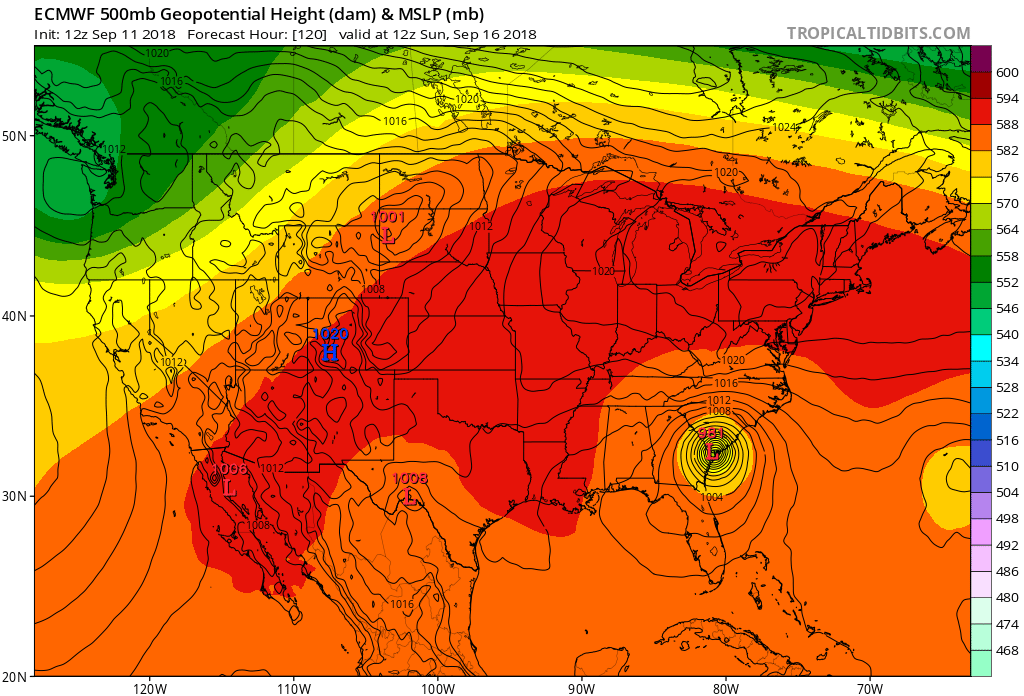
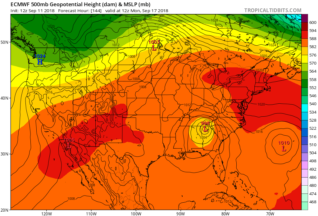
12Z Euro

0 likes
M a r k
- - - - -
Join us in chat: Storm2K Chatroom Invite. Android and IOS apps also available.
The posts in this forum are NOT official forecasts and should not be used as such. Posts are NOT endorsed by any professional institution or STORM2K.org. For official information and forecasts, please refer to NHC and NWS products.
Re: ATL: FLORENCE - Models
EquusStorm wrote:Guess it's a good thing that South Carolina has taken evacuations for this pretty seriously given trends
That model run could bring hurricane force gusts to Virgina, N.C., S.C., & GA. Heck, any further shift and you'd minimally have Gale Warnings for extreme N. Fla. offshore waters too. Be quite interesting to see the ensembles as well as tonight's EURO run
1 likes
Andy D
(For official information, please refer to the NHC and NWS products.)
(For official information, please refer to the NHC and NWS products.)
Re: ATL: FLORENCE - Models
So is the ridging that much stronger inland to the west forcing the SW track this run?
0 likes

Re: ATL: FLORENCE - Models
EquusStorm wrote:Guess it's a good thing that South Carolina has taken evacuations for this pretty seriously given trends
Yeah, but a lot of the SC folks have evacuated to northern GA.
1 likes
-
northjaxpro

- S2K Supporter
- Posts: 8900
- Joined: Mon Sep 27, 2010 11:21 am
- Location: Jacksonville, FL
Re: ATL: FLORENCE - Models
Ken711 wrote:So is the ridging that much stronger inland to the west forcing the SW track this run?
Based on the 12Z EURO run, yes!!
0 likes
NEVER, EVER SAY NEVER in the tropics and weather in general, and most importantly, with life itself!!
________________________________________________________________________________________
Fay 2008 Beryl 2012 Debby 2012 Colin 2016 Hermine 2016 Julia 2016 Matthew 2016 Irma 2017 Dorian 2019
________________________________________________________________________________________
Fay 2008 Beryl 2012 Debby 2012 Colin 2016 Hermine 2016 Julia 2016 Matthew 2016 Irma 2017 Dorian 2019
Re: ATL: FLORENCE - Models
BobHarlem wrote:PTPatrick wrote:This would’ve a positive development from a surge perspective. If the storm doesn’t fully move onshore in NC the full surge likely wouldn’t come in yet...although it would still be a large surge just east where the center parks for a bit and it wouldn’t go down for a couple days due to continuous onshore fetch. But the surge in SC on that track would be minimal due to prolonged offshore fetch for days.
If the eye diameter is as big as the HWRF indicates, I'm not so sure about that
I disagree. On that track and with a very slow motion, I'd thing that there could be a tremendous surge in the northern quad. as the center were to slide southward (especially if timed with the seasonal high tides anticipated later this week)
0 likes
Andy D
(For official information, please refer to the NHC and NWS products.)
(For official information, please refer to the NHC and NWS products.)
Who is online
Users browsing this forum: No registered users and 82 guests