ATL: MICHAEL - Post-Tropical - Discussion

Moderator: S2k Moderators

Message
Author
Blow_Hard
Tropical Storm
Tropical Storm
Posts: 156
Joined: Sun Aug 07, 2016 4:29 pm
Location: Panama City, FL

Re: ATL: MICHAEL - Hurricane - Discussion

#2881 Postby Blow_Hard » Wed Oct 10, 2018 7:42 am

panamatropicwatch wrote:Now it comes down to wobbles whether downtown Panama City gets the storm surge or not. Mexico Beach, Port St. Joe and Apalachicola is not looking good.


Hey PTW...are you guys still in Bay County or did you evacuate. My wife and I are with her elderly parents in the Bylsma Manor subdivision. Just waiting, watching and praying.
0 likes   

User avatar
Buck
S2K Supporter
S2K Supporter
Posts: 1173
Joined: Fri Sep 10, 2004 12:04 pm
Location: Atlanta, GA

Re: ATL: MICHAEL - Hurricane - Discussion

#2882 Postby Buck » Wed Oct 10, 2018 7:42 am

I saw someone post a chart that details the offshore slopes of the Gulf Coast and it illuminated why storm surges can get up to 24 feet in Mississippi but why that's more unlikely for, say, Port St. Joe, FL. I've googled it but I'm mostly just getting seafloor or oil rig maps. Does anyone have it handy? Much appreciated.
1 likes   

User avatar
Hurricane Andrew
S2K Supporter
S2K Supporter
Posts: 1891
Age: 26
Joined: Sun May 23, 2010 2:53 pm
Location: KS

Re: ATL: MICHAEL - Hurricane - Discussion

#2883 Postby Hurricane Andrew » Wed Oct 10, 2018 7:43 am

Buck wrote:I saw someone post a chart that details the offshore slopes of the Gulf Coast and it illuminated why storm surges can get up to 24 feet in Mississippi but why that's more unlikely for, say, Port St. Joe, FL. I've googled it but I'm mostly just getting seafloor or oil rig maps. Does anyone have it handy? Much appreciated.

That would be wxman57's chart. It has to do with proximity of deep water to the coast.
1 likes   

The Enthusiast
NREMT-AEMT, WX nerd

Irene '11, Sandy '12, Irma '17 (SAR)

"Hard to think we were born to live this way..." -Wage War

User avatar
Hurricane Andrew
S2K Supporter
S2K Supporter
Posts: 1891
Age: 26
Joined: Sun May 23, 2010 2:53 pm
Location: KS

Re: ATL: MICHAEL - Hurricane - Discussion

#2884 Postby Hurricane Andrew » Wed Oct 10, 2018 7:44 am

wxman57 wrote:
chaser1 wrote:
The difference is amazing between max (Cat 3) surge near Panama City vs. Apalachca Bay. Didn't realize there'd be that much of a difference. In addition to the shallower waters further east, I suppose there's also the fact that a greater forcing of water "pile-up" would exist to the east, whereas further west along the Panhandle the increased storm surge can at least spread out a greater distance perpendicular to the coastline?


One key factor in storm surge calculations is called the "Shoaling Factor". The shoaling factor relates to the distance offshore to the 10-fathom depth (60 ft). The closer to the coast that 10-fathom depth, the less the storm surge threat. Note that for Pensacola to Panama City, the multiplier in the storm surge calculation is only about 0.4. Compare that to 1.8 in Vermilion Bay or 1.75 on the Mississippi Coast (or the 1.1 to 1.2 in Apalachee Bay). The shoaling factor is one of the more significant factors in storm surge height.

Here's a graphic I made from a similar chart in my old (very old) Mariner's Shore Protection Manual. The calculation methods in that manual still work well today.

http://wxman57.com/images/shoaling.JPG

This is for the user who asked about it above
2 likes   

The Enthusiast
NREMT-AEMT, WX nerd

Irene '11, Sandy '12, Irma '17 (SAR)

"Hard to think we were born to live this way..." -Wage War

User avatar
MGC
S2K Supporter
S2K Supporter
Posts: 5899
Joined: Sun Mar 23, 2003 9:05 pm
Location: Pass Christian MS, or what is left.

Re: ATL: MICHAEL - Hurricane - Discussion

#2885 Postby MGC » Wed Oct 10, 2018 7:44 am

I'm speechless....could this possibly reach high end cat 4? Yup, could even flirt with Cat-5. Things are looking grave for PCB to Port St. Joe. Would not want to be under that eyewall. Sadly many are going to perish this afternoon somewhere along the coast. Sad..sad..sad.....MGC
2 likes   

User avatar
cycloneye
Admin
Admin
Posts: 145456
Age: 68
Joined: Thu Oct 10, 2002 10:54 am
Location: San Juan, Puerto Rico

Re: ATL: MICHAEL - Hurricane - Discussion

#2886 Postby cycloneye » Wed Oct 10, 2018 7:44 am

supercane4867 wrote:Pressure seems to be leveling off at least for now. That's good news


No sign of an EWRC?
0 likes   
Visit the Caribbean-Central America Weather Thread where you can find at first post web cams,radars
and observations from Caribbean basin members Click Here

User avatar
ColdMiser123
Professional-Met
Professional-Met
Posts: 904
Age: 29
Joined: Mon Sep 26, 2016 3:26 pm
Location: Northeast US

Re: ATL: MICHAEL - Hurricane - Discussion

#2887 Postby ColdMiser123 » Wed Oct 10, 2018 7:44 am

supercane4867 wrote:Pressure seems to be leveling off at least for now. That's good news


NOAA2 had an extrapolated pressure near 932 this pass, down 2 mb from the previous pass an hour ago.
Last edited by ColdMiser123 on Wed Oct 10, 2018 7:46 am, edited 2 times in total.
0 likes   
B.S., M.S., Meteorology & Atmospheric Science

User avatar
tropicwatch
Category 5
Category 5
Posts: 3389
Age: 61
Joined: Sat Jun 02, 2007 10:01 am
Location: Panama City Florida
Contact:

Re: ATL: MICHAEL - Hurricane - Discussion

#2888 Postby tropicwatch » Wed Oct 10, 2018 7:44 am

Blow_Hard wrote:
panamatropicwatch wrote:Now it comes down to wobbles whether downtown Panama City gets the storm surge or not. Mexico Beach, Port St. Joe and Apalachicola is not looking good.


Hey PTW...are you guys still in Bay County or did you evacuate. My wife and I are with her elderly parents in the Bylsma Manor subdivision. Just waiting, watching and praying.

Was able to convince them that discretion was the better part of valor. We got out!
5 likes   
Tropicwatch


Agnes 72', Eloise 75, Elena 85', Kate 85', Charley 86', Florence 88', Beryl 94', Dean 95', Erin 95', Opal 95', Earl 98', Georges 98', Ivan 2004', Arlene 2005', Dennis 2005', Ida 2009' Debby 2012' Irma 2017' Michael 2018'

xironman
S2K Supporter
S2K Supporter
Posts: 2522
Joined: Sun Jun 10, 2007 4:53 pm
Location: NoVA

Re: ATL: MICHAEL - Hurricane - Discussion

#2889 Postby xironman » Wed Oct 10, 2018 7:46 am

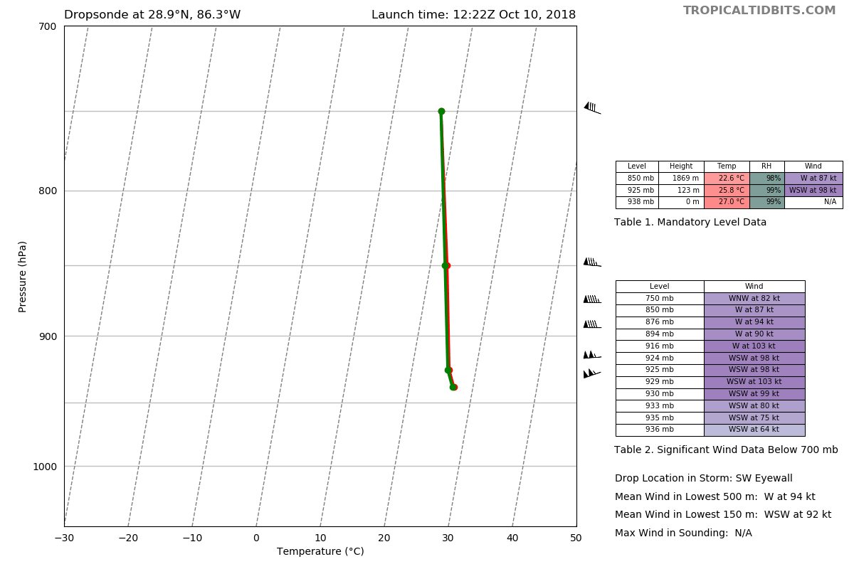
Texas Snowman wrote:@MikeWDross — Recon dropsonde measuring incredible winds aloft in the eye-wall. 176 MPH around 1k feet. 181 mph around 3k feet.


You don't want to be around when one of those mesovortices brings that down to the surface.
3 likes   

tolakram
Admin
Admin
Posts: 20012
Age: 62
Joined: Sun Aug 27, 2006 8:23 pm
Location: Florence, KY (name is Mark)

Re: ATL: MICHAEL - Hurricane - Discussion

#2890 Postby tolakram » Wed Oct 10, 2018 7:46 am

supercane4867 wrote:Pressure seems to be leveling off at least for now. That's good news


Not sure about that. I would hope it's not falling as fast, but still falling.

Image
2 likes   
M a r k
- - - - -
Join us in chat: Storm2K Chatroom Invite. Android and IOS apps also available.

The posts in this forum are NOT official forecasts and should not be used as such. Posts are NOT endorsed by any professional institution or STORM2K.org. For official information and forecasts, please refer to NHC and NWS products.

User avatar
chaser1
S2K Supporter
S2K Supporter
Posts: 5475
Age: 64
Joined: Sat Oct 15, 2005 5:59 pm
Location: Longwood, Fl

Re: ATL: MICHAEL - Hurricane - Discussion

#2891 Postby chaser1 » Wed Oct 10, 2018 7:46 am

RL3AO wrote:Somehow the satellite appearance has improved quite a bit in the last 30 minutes.


You have got to be kidding - I feel like I just woke up in Fiji..... on a very bad day! So, having just woke up and trying to catch up, absorb, and make sense of the latest satellite appearance and official updates along with the fragments of sporadic wind & pressure reports still being reported.

In a nutshell, what is the latest recon reported pressure and max wind speed as things stand now?
0 likes   
Andy D

(For official information, please refer to the NHC and NWS products.)

User avatar
Miami Storm Tracker
Category 4
Category 4
Posts: 910
Age: 67
Joined: Sun Jun 13, 2010 10:12 pm
Location: Key Largo, Fla.
Contact:

Re: ATL: MICHAEL - Hurricane - Discussion

#2892 Postby Miami Storm Tracker » Wed Oct 10, 2018 7:47 am

Good Morning,

waking up to an even more impressive storm than last night. Wishing all of you up there the best stay safe.
0 likes   

USTropics
Professional-Met
Professional-Met
Posts: 2659
Joined: Sun Aug 12, 2007 3:45 am
Location: Florida State University

Re: ATL: MICHAEL - Hurricane - Discussion

#2893 Postby USTropics » Wed Oct 10, 2018 7:47 am

cycloneye wrote:
supercane4867 wrote:Pressure seems to be leveling off at least for now. That's good news


No sign of an EWRC?


No sign of an EWRC. Current eyewall has been open and closed throughout the night/morning. It's been closed for ~2 hours now according to VDM messages.
2 likes   

tolakram
Admin
Admin
Posts: 20012
Age: 62
Joined: Sun Aug 27, 2006 8:23 pm
Location: Florence, KY (name is Mark)

Re: ATL: MICHAEL - Hurricane - Discussion

#2894 Postby tolakram » Wed Oct 10, 2018 7:47 am

2 likes   
M a r k
- - - - -
Join us in chat: Storm2K Chatroom Invite. Android and IOS apps also available.

The posts in this forum are NOT official forecasts and should not be used as such. Posts are NOT endorsed by any professional institution or STORM2K.org. For official information and forecasts, please refer to NHC and NWS products.

supercane4867
Category 5
Category 5
Posts: 4966
Joined: Wed Nov 14, 2012 10:43 am

Re: ATL: MICHAEL - Hurricane - Discussion

#2895 Postby supercane4867 » Wed Oct 10, 2018 7:47 am

Image
4 likes   

tolakram
Admin
Admin
Posts: 20012
Age: 62
Joined: Sun Aug 27, 2006 8:23 pm
Location: Florence, KY (name is Mark)

Re: ATL: MICHAEL - Hurricane - Discussion

#2896 Postby tolakram » Wed Oct 10, 2018 7:48 am

2 likes   
M a r k
- - - - -
Join us in chat: Storm2K Chatroom Invite. Android and IOS apps also available.

The posts in this forum are NOT official forecasts and should not be used as such. Posts are NOT endorsed by any professional institution or STORM2K.org. For official information and forecasts, please refer to NHC and NWS products.

otowntiger
Category 5
Category 5
Posts: 1921
Joined: Tue Aug 31, 2004 7:06 pm

Re: ATL: MICHAEL - Hurricane - Discussion

#2897 Postby otowntiger » Wed Oct 10, 2018 7:48 am

I fear that portions of the gulf coast around Panama City will look like Homestead back in '92. :eek:
4 likes   

supercane4867
Category 5
Category 5
Posts: 4966
Joined: Wed Nov 14, 2012 10:43 am

Re: ATL: MICHAEL - Hurricane - Discussion

#2898 Postby supercane4867 » Wed Oct 10, 2018 7:49 am

Eye drop has 936mb with 64kt winds. That indicates actual central pressure of 930mb

Image
1 likes   

User avatar
NDG
S2K Supporter
S2K Supporter
Posts: 15446
Joined: Sun Jul 09, 2006 10:14 pm
Location: Orlando, FL

Re: ATL: MICHAEL - Hurricane - Discussion

#2899 Postby NDG » Wed Oct 10, 2018 7:51 am

Dropsonde from the AF recon at 12z in the eastern eyewall measured 179 mph winds just around 750 feet above the surface, incredible.

Image
2 likes   

User avatar
Buck
S2K Supporter
S2K Supporter
Posts: 1173
Joined: Fri Sep 10, 2004 12:04 pm
Location: Atlanta, GA

Re: ATL: MICHAEL - Hurricane - Discussion

#2900 Postby Buck » Wed Oct 10, 2018 7:51 am

Hurricane Andrew wrote:
wxman57 wrote:
chaser1 wrote:
The difference is amazing between max (Cat 3) surge near Panama City vs. Apalachca Bay. Didn't realize there'd be that much of a difference. In addition to the shallower waters further east, I suppose there's also the fact that a greater forcing of water "pile-up" would exist to the east, whereas further west along the Panhandle the increased storm surge can at least spread out a greater distance perpendicular to the coastline?


One key factor in storm surge calculations is called the "Shoaling Factor". The shoaling factor relates to the distance offshore to the 10-fathom depth (60 ft). The closer to the coast that 10-fathom depth, the less the storm surge threat. Note that for Pensacola to Panama City, the multiplier in the storm surge calculation is only about 0.4. Compare that to 1.8 in Vermilion Bay or 1.75 on the Mississippi Coast (or the 1.1 to 1.2 in Apalachee Bay). The shoaling factor is one of the more significant factors in storm surge height.

Here's a graphic I made from a similar chart in my old (very old) Mariner's Shore Protection Manual. The calculation methods in that manual still work well today.

http://wxman57.com/images/shoaling.JPG

This is for the user who asked about it above


THANK YOU!
0 likes   


Return to “2018”

Who is online

Users browsing this forum: No registered users and 1 guest